ATL: KARL - Ex-Hurricane - Discussion

Moderator: S2k Moderators

Message
Author
User avatar
AussieMark
Category 5
Category 5
Posts: 5858
Joined: Tue Sep 02, 2003 6:36 pm
Location: near Sydney, Australia

Re:

#1041 Postby AussieMark » Thu Sep 16, 2010 7:11 am

KWT wrote:I'm a bit surprised they didn't go a little higher actually but they clearly believed the winds hadn't quite caught up with the wind speeds just yet...

I'm willing to bet the next forecast cycle from the NHC have Karl making landfall as a category-2 now...


The way this is going and the way the last few days have been would not be shocked at all to see it strengthen to a cat 3 before its second landfall.

Heck Julia was never supposed to even get close to cat 4.
0 likes   

User avatar
Aquawind
Category 5
Category 5
Posts: 6714
Age: 61
Joined: Mon Jun 16, 2003 10:41 pm
Location: Salisbury, NC
Contact:

#1042 Postby Aquawind » Thu Sep 16, 2010 7:11 am

WOW!! Wow wow!! Amazing organization for coming off the Yukatan.. AMAZING :uarrow:
0 likes   

User avatar
brunota2003
S2K Supporter
S2K Supporter
Posts: 9476
Age: 34
Joined: Sat Jul 30, 2005 9:56 pm
Location: Stanton, KY...formerly Havelock, NC
Contact:

#1043 Postby brunota2003 » Thu Sep 16, 2010 7:12 am

SMFR did pick up a nonflagged wind of 57 knots, which for once lines up perfectly with the flight level reduction (56.8 for 80%). Perhaps they should bump it up to 60 knots, encase stronger winds were not sampled (only 3 knots higher from those already found). Even if it is not at 60 knots right now, I'm sure within a few passes it will have strengthened some.
0 likes   

User avatar
Aquawind
Category 5
Category 5
Posts: 6714
Age: 61
Joined: Mon Jun 16, 2003 10:41 pm
Location: Salisbury, NC
Contact:

Re: Re:

#1044 Postby Aquawind » Thu Sep 16, 2010 7:13 am

AussieMark wrote:
KWT wrote:I'm a bit surprised they didn't go a little higher actually but they clearly believed the winds hadn't quite caught up with the wind speeds just yet...

I'm willing to bet the next forecast cycle from the NHC have Karl making landfall as a category-2 now...


The way this is going and the way the last few days have been would not be shocked at all to see it strengthen to a cat 3 before its second landfall.

Heck Julia was never supposed to even get close to cat 4.


Yep the intensity has got to be adjusted..Wow..
0 likes   

User avatar
KWT
Category 5
Category 5
Posts: 31415
Joined: Tue Aug 17, 2004 11:02 am
Location: UK!!!

#1045 Postby KWT » Thu Sep 16, 2010 7:14 am

Yeah Brutona, I don't think its going to take this one very long at all to strengthen, I see no reason not to go for something like 90-95kts at landfall given the current trends that are clear for everyone to see.
0 likes   
Personal Forecast Disclaimer:
The posts in this forum are NOT official forecast and should not be used as such. They are just the opinion of the poster and may or may not be backed by sound meteorological data. They are NOT endorsed by any professional institution or storm2k.org. For official information, please refer to the NHC and NWS products

User avatar
brunota2003
S2K Supporter
S2K Supporter
Posts: 9476
Age: 34
Joined: Sat Jul 30, 2005 9:56 pm
Location: Stanton, KY...formerly Havelock, NC
Contact:

#1046 Postby brunota2003 » Thu Sep 16, 2010 7:17 am

I am also curious what the intensity was as it moved across the Yucatan, and then right as it moved off...did it really go from 40 mph to 65-70 mph in the span of not even 12 hours (between the time it was overland and moved offshore)?
0 likes   

Vortmax1
Category 1
Category 1
Posts: 360
Joined: Wed Jul 07, 2010 11:35 pm
Location: Port Salerno, FL
Contact:

#1047 Postby Vortmax1 » Thu Sep 16, 2010 7:18 am

Wow!
Karl held together amazingly well over the Yucatan.
Looks like he's really pouring it on right now.
Certainly at hurricane level now...just how much stronger before second landfall is my question?
0 likes   

User avatar
HURAKAN
Professional-Met
Professional-Met
Posts: 46086
Age: 38
Joined: Thu May 20, 2004 4:34 pm
Location: Key West, FL
Contact:

#1048 Postby HURAKAN » Thu Sep 16, 2010 7:20 am

Image

Latest
0 likes   

hurricaneCW
Category 5
Category 5
Posts: 1792
Joined: Wed Mar 03, 2010 6:20 am
Location: Toms River, NJ

Re: ATL: KARL - Tropical Storm - Discussion

#1049 Postby hurricaneCW » Thu Sep 16, 2010 7:20 am

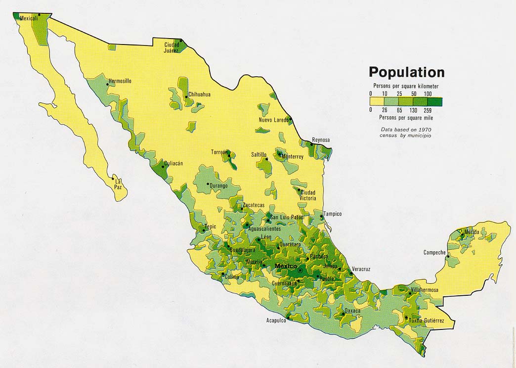
Will it landfall in a populated area or a quiet area?
0 likes   

plasticup

Re: ATL: KARL - Tropical Storm - Discussion

#1050 Postby plasticup » Thu Sep 16, 2010 7:27 am

hurricaneCW wrote:Will it landfall in a populated area or a quiet area?

Right now, it is forecast to make landfall near Tampico. North of there is sparsely populated, south is more heavily populated.

Image
0 likes   

cwachal

#1051 Postby cwachal » Thu Sep 16, 2010 7:29 am

000
WTNT33 KNHC 161224
TCPAT3
BULLETIN
TROPICAL STORM KARL SPECIAL ADVISORY NUMBER 8
NWS TPC/NATIONAL HURRICANE CENTER MIAMI FL AL132010
730 AM CDT THU SEP 16 2010

...HURRICANE HUNTER AIRCRAFT FINDS KARL STRONGER AND SOUTH OF THE
PREVIOUS FORECAST TRACK...


SUMMARY OF 730 AM CDT...1230 UTC...INFORMATION
----------------------------------------------
LOCATION...19.7N 92.2W
ABOUT 110 MI...180 KM W OF CAMPECHE MEXICO
ABOUT 350 MI...560 KM ESE OF TUXPAN MEXICO
MAXIMUM SUSTAINED WINDS...65 MPH...100 KM/HR
PRESENT MOVEMENT...WNW OR 285 DEGREES AT 9 MPH...15 KM/HR
MINIMUM CENTRAL PRESSURE...987 MB...29.15 INCHES


000
WTNT43 KNHC 161224
TCDAT3
TROPICAL STORM KARL SPECIAL DISCUSSION NUMBER 8
NWS TPC/NATIONAL HURRICANE CENTER MIAMI FL AL132010
730 AM CDT THU SEP 16 2010

AN AIR FORCE RESERVE HURRICANE HUNTER AIRCRAFT FOUND THAT KARL WAS
SOUTH OF THE PREVIOUS FORECAST TRACK BY ABOUT 30 N MI. THE PLANE
MEASURED A CENTRAL PRESSURE OF 987 MB...WITH FLIGHT-LEVEL AND SFMR
WINDS SUPPORTING AN INITIAL INTENSITY OF 55 KT. THIS SPECIAL
ADVISORY IS BEING ISSUED TO SHIFT THE FIRST 36-48 HR OF THE
FORECAST TRACK SOUTHWARD AND TO SIGNIFICANTLY INCREASE THE
INTENSITY FORECAST.


FORECAST POSITIONS AND MAX WINDS

INITIAL 16/1230Z 19.7N 92.2W 55 KT
12HR VT 16/1800Z 20.1N 93.7W 65 KT
24HR VT 17/0600Z 20.5N 94.5W 75 KT
36HR VT 17/1800Z 20.8N 96.8W 85 KT
48HR VT 18/0600Z 21.0N 98.5W 75 KT...INLAND
72HR VT 19/0600Z 21.0N 101.0W 25 KT...INLAND
96HR VT 20/0600Z 21.0N 103.5W 20 KT...POST-TROP/REMNT LOW
120HR VT 21/0600Z...DISSIPATED

$$
FORECASTER BEVEN
0 likes   

User avatar
HURAKAN
Professional-Met
Professional-Met
Posts: 46086
Age: 38
Joined: Thu May 20, 2004 4:34 pm
Location: Key West, FL
Contact:

#1052 Postby HURAKAN » Thu Sep 16, 2010 7:31 am

Image

1st visible
0 likes   

User avatar
KWT
Category 5
Category 5
Posts: 31415
Joined: Tue Aug 17, 2004 11:02 am
Location: UK!!!

#1053 Postby KWT » Thu Sep 16, 2010 7:33 am

Wow its looking good there Hurakan, won't be long before this system is a hurricane I'd imagine, its got very good conditions aloft...

Thats reflected by the fact the NHC is now going upto 85kts and category-2 at landfall...and even that maybe a little on the low side if the current trend continues.

Looks like its heading towards a rather populated region as well....
0 likes   
Personal Forecast Disclaimer:
The posts in this forum are NOT official forecast and should not be used as such. They are just the opinion of the poster and may or may not be backed by sound meteorological data. They are NOT endorsed by any professional institution or storm2k.org. For official information, please refer to the NHC and NWS products

hurricaneCW
Category 5
Category 5
Posts: 1792
Joined: Wed Mar 03, 2010 6:20 am
Location: Toms River, NJ

Re: ATL: KARL - Tropical Storm - Discussion

#1054 Postby hurricaneCW » Thu Sep 16, 2010 7:33 am

plasticup wrote:
hurricaneCW wrote:Will it landfall in a populated area or a quiet area?

Right now, it is forecast to make landfall near Tampico. North of there is sparsely populated, south is more heavily populated.

So with the track a bit more south, I assume it might be more likely to landfall south of Tampico or along a more populated area.
0 likes   

plasticup

Re: ATL: KARL - Tropical Storm - Discussion

#1055 Postby plasticup » Thu Sep 16, 2010 7:35 am

hurricaneCW wrote:
plasticup wrote:
hurricaneCW wrote:Will it landfall in a populated area or a quiet area?

Right now, it is forecast to make landfall near Tampico. North of there is sparsely populated, south is more heavily populated.


So with the track a bit more south, I assume it might be more likely to landfall south of Tampico or along a more populated area.

Looks like it. We aren't talking South Florida density, but it is most definitely a well populated area.
0 likes   

tolakram
Admin
Admin
Posts: 19990
Age: 61
Joined: Sun Aug 27, 2006 8:23 pm
Location: Florence, KY (name is Mark)

Re: ATL: KARL - Tropical Storm - Discussion

#1056 Postby tolakram » Thu Sep 16, 2010 7:36 am

Image
0 likes   
M a r k
- - - - -
Join us in chat: Storm2K Chatroom Invite. Android and IOS apps also available.

The posts in this forum are NOT official forecasts and should not be used as such. Posts are NOT endorsed by any professional institution or STORM2K.org. For official information and forecasts, please refer to NHC and NWS products.

Aric Dunn
Category 5
Category 5
Posts: 21238
Age: 42
Joined: Sun Sep 19, 2004 9:58 pm
Location: Ready for the Chase.
Contact:

#1057 Postby Aric Dunn » Thu Sep 16, 2010 7:38 am

its very likely to be a hurricane at 11am .. not surprised since it maintained at tight inner core over the Yucatan.
0 likes   
Note: If I make a post that is brief. Please refer back to previous posts for the analysis or reasoning. I do not re-write/qoute what my initial post said each time.
If there is nothing before... then just ask :)

Space & Atmospheric Physicist, Embry-Riddle Aeronautical University,
I believe the sky is falling...

User avatar
alan1961
Category 2
Category 2
Posts: 771
Joined: Mon Mar 20, 2006 11:58 am
Location: Derby, Derbyshire, England
Contact:

Re: ATL: KARL - Tropical Storm - Discussion

#1058 Postby alan1961 » Thu Sep 16, 2010 7:38 am

plasticup wrote:
hurricaneCW wrote:Will it landfall in a populated area or a quiet area?

Right now, it is forecast to make landfall near Tampico. North of there is sparsely populated, south is more heavily populated.

Image


Poza Rica has a population of around 180,000..it may get
very close there.
http://en.wikipedia.org/wiki/Poza_Rica,_Veracruz

Image
0 likes   

User avatar
KWT
Category 5
Category 5
Posts: 31415
Joined: Tue Aug 17, 2004 11:02 am
Location: UK!!!

Re:

#1059 Postby KWT » Thu Sep 16, 2010 7:43 am

Aric Dunn wrote:its very likely to be a hurricane at 11am .. not surprised since it maintained at tight inner core over the Yucatan.


Yeah and it probably helped that it was blowing up in terms of convection as well onto landfall, these systems almost always do well overland in that situation providing they can get out over water quickly enough to make use of that advantage.

I do think its going to be a hurricane very soon, going to be a good un to watch this one, I wouldn't be shocked if this one does become a powerful cat-2...
0 likes   
Personal Forecast Disclaimer:
The posts in this forum are NOT official forecast and should not be used as such. They are just the opinion of the poster and may or may not be backed by sound meteorological data. They are NOT endorsed by any professional institution or storm2k.org. For official information, please refer to the NHC and NWS products

User avatar
HURAKAN
Professional-Met
Professional-Met
Posts: 46086
Age: 38
Joined: Thu May 20, 2004 4:34 pm
Location: Key West, FL
Contact:

Re: ATL: KARL - Tropical Storm - Discussion

#1060 Postby HURAKAN » Thu Sep 16, 2010 7:45 am

Image

I will be surprised if it doesn't become a major hurricane before landfall
0 likes   


Return to “2010”

Who is online

Users browsing this forum: No registered users and 43 guests