WPAC: FANAPI - Tropical Depression (1011/12W/Inday)
Moderator: S2k Moderators
-
RobWESTPACWX
- WestPACMet

- Posts: 1616
- Joined: Fri Sep 17, 2010 2:26 am
- Location: Tokyo, Japan
- Contact:
Re: WPAC: FANAPI - Typhoon (1011/12W/Inday)
That is exactly the one that did all that damage last typhoon season.
0 likes
Satellites, Charts and Forecasting tools for East Asia at WESTERNPACIFICWEATHER.COM

Re: WPAC: FANAPI - Typhoon (1011/12W/Inday)
This is why I am worried: http://www.chinapost.com.tw/commentary/ ... ervoir.htm
Sepat hit Taiwan as a very weak typhoon (though at one point, it was classified a Cat 5 super typhoon). Morakot was the strongest to hit in recorded history for Taiwan (about 50 years) and it was only a Cat 1, but the precipitation it produced was what resulted in so many deaths. Fanapi is predicted to be even stronger, but it's not the strength I'm worried about as much as the rainfall they could get with this storm. The Shihmen dam has its known problems and has long been feared to be in danger of bursting. It wasn't affected quite as much by Morakot, since Morakot hit the southern half of the island the worst, but right now, this could be the storm Taiwan has long feared. I don't know what precautions they've been able to get in place over the period of a year...but I know they were launched in to a 100 billion dollar construction project that was supposed to take 3 years to complete. I sure hope everything will be fine, there...but they are in my thoughts, right now, as we watch this storm heading their way.
Any way you look at it, probably going to be a lot of flooding and damage. I just hope the loss of life isn't as great as it was last year. A village of about 117 was killed when a mudslide wiped them out...but there were close to 700 killed total.
0 likes
-
RobWESTPACWX
- WestPACMet
- Posts: 1616
- Joined: Fri Sep 17, 2010 2:26 am
- Location: Tokyo, Japan
- Contact:
Re: WPAC: FANAPI - Typhoon (1011/12W/Inday)
I couldnt agree more, I am exceptionally worried about this system, flash flooding is also going to be a problem. The mountains in southern taiwan are not very conducive for heavy rainfalls.
0 likes
Satellites, Charts and Forecasting tools for East Asia at WESTERNPACIFICWEATHER.COM
-
RobWESTPACWX
- WestPACMet
- Posts: 1616
- Joined: Fri Sep 17, 2010 2:26 am
- Location: Tokyo, Japan
- Contact:
Want to put out there real fast, I have a new update at Westernpacificweather.com. Or you can find it at youtube...
I would post it here for sake of keeping it simple, but not sure how the admin of this site would handle that.
I would post it here for sake of keeping it simple, but not sure how the admin of this site would handle that.
0 likes
Satellites, Charts and Forecasting tools for East Asia at WESTERNPACIFICWEATHER.COM
-
Simone Lussardi
- Tropical Low

- Posts: 24
- Age: 50
- Joined: Sat Sep 11, 2004 12:00 am
- Location: Foshan, Guangdong, China
Re: WPAC: FANAPI - Typhoon (1011/12W/Inday)
Guys, Taiwan is the super-typhoon capital of the globe I think, they have had more CAT 5 landfall than any other location on earth, this is easily verifiable on Unisys website archive.
The last monster was STY Bilis in 2000, and after that they have many category 4 landfalls or "eyewall brush".
http://www.emergency.co.nz/archive/bilis.html

On one side, Taiwan is very well prepared for the winds, but the problem as someone mentioned is only the rain. When the wind collides with the mountains, they unlesh incredible rains, as documented by James Reynolds in this video:
http://www.typhoonfury.com/Photo%20-%20 ... sepat.html
Check part II, the flooding in Taroko Gorges !
Morakot was exceptional because the eye stalled on the coast for a long time, and it was a large system, which unleashed over 1000 mm of rain in 24 hours in places.
Fanapi should move fast across Taiwan, and is neither as large as Sepat nor Morakot.
The last monster was STY Bilis in 2000, and after that they have many category 4 landfalls or "eyewall brush".
http://www.emergency.co.nz/archive/bilis.html
On one side, Taiwan is very well prepared for the winds, but the problem as someone mentioned is only the rain. When the wind collides with the mountains, they unlesh incredible rains, as documented by James Reynolds in this video:
http://www.typhoonfury.com/Photo%20-%20 ... sepat.html
Check part II, the flooding in Taroko Gorges !
Morakot was exceptional because the eye stalled on the coast for a long time, and it was a large system, which unleashed over 1000 mm of rain in 24 hours in places.
Fanapi should move fast across Taiwan, and is neither as large as Sepat nor Morakot.
0 likes
-
phwxenthusiast
- Category 2

- Posts: 637
- Joined: Wed Mar 24, 2010 3:10 am
- Location: Holbrook, NY (Long Island)


-
phwxenthusiast
- Category 2
- Posts: 637
- Joined: Wed Mar 24, 2010 3:10 am
- Location: Holbrook, NY (Long Island)
The 1700l report from Ishigaki-Maezato, according to the JMA website, was 23 m/s (44 knot) winds.
Miyakojima Airport is reporting 16 m/s (31 knots) and a pressure of 990 hPa; Shimojishima Airport reporting 23 m/s. Ohara Airport (on Iriomotejima) is reporting 18 m/s; Hateruma reporting 17 m/s.
Even Yonagunijima, the western-most island in the Ryukyus, is reporting 18 m/s with a pressure of 997.
Miyakojima Airport is reporting 16 m/s (31 knots) and a pressure of 990 hPa; Shimojishima Airport reporting 23 m/s. Ohara Airport (on Iriomotejima) is reporting 18 m/s; Hateruma reporting 17 m/s.
Even Yonagunijima, the western-most island in the Ryukyus, is reporting 18 m/s with a pressure of 997.
0 likes

-
RobWESTPACWX
- WestPACMet
- Posts: 1616
- Joined: Fri Sep 17, 2010 2:26 am
- Location: Tokyo, Japan
- Contact:
Re: WPAC: FANAPI - Typhoon (1011/12W/Inday)

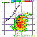
Latest obs out of the southern Ryuku, expecting this to increase though odviosly, outer eye wall in moving in close, according to radar below, winds should increase rapidly as that area nears it. Going to be interesting out that area fairs. I forecasted a max of 60-70kts sustained, think that may be high ended though..

0 likes
Satellites, Charts and Forecasting tools for East Asia at WESTERNPACIFICWEATHER.COM
-
RobWESTPACWX
- WestPACMet
- Posts: 1616
- Joined: Fri Sep 17, 2010 2:26 am
- Location: Tokyo, Japan
- Contact:
-
Simone Lussardi
- Tropical Low
- Posts: 24
- Age: 50
- Joined: Sat Sep 11, 2004 12:00 am
- Location: Foshan, Guangdong, China
Re:
RobWESTPACWX wrote:Thats showing winds around 50mph 46kts by the way....
Yes, and don't forget that they are 10 minutes average sustained winds, not 1 minute as in the USA. Gusts are already over hurricane force in the area, as shown in the observation from Wunder:
http://www.wunderground.com/history/air ... atename=NA

0 likes
-
RobWESTPACWX
- WestPACMet
- Posts: 1616
- Joined: Fri Sep 17, 2010 2:26 am
- Location: Tokyo, Japan
- Contact:
Re: WPAC: FANAPI - Typhoon (1011/12W/Inday)
Thanks for pointing that out Simon!
Also this is from Ship WX, 38kts sustained of the southern jima, I think this is from a land station though, thank god we don't have any more obs from this area on this sight right?

Also this is from Ship WX, 38kts sustained of the southern jima, I think this is from a land station though, thank god we don't have any more obs from this area on this sight right?
0 likes
Satellites, Charts and Forecasting tools for East Asia at WESTERNPACIFICWEATHER.COM
WTPQ20 RJTD 180900
RSMC TROPICAL CYCLONE ADVISORY
NAME TY 1011 FANAPI (1011)
ANALYSIS
PSTN 180900UTC 23.8N 124.8E GOOD
MOVE WNW 08KT
PRES 940HPA
MXWD 085KT
GUST 120KT
50KT 80NM
30KT 180NM
FORECAST
24HF 190900UTC 24.1N 120.0E 75NM 70%
MOVE W 11KT
PRES 975HPA
MXWD 060KT
GUST 085KT
45HF 200600UTC 24.2N 117.2E 110NM 70%
MOVE W 06KT
PRES 996HPA
MXWD 040KT
GUST 060KT
69HF 210600UTC 24.6N 113.2E 160NM 70% TROPICAL DEPRESSION =
0 likes
-
Simone Lussardi
- Tropical Low
- Posts: 24
- Age: 50
- Joined: Sat Sep 11, 2004 12:00 am
- Location: Foshan, Guangdong, China
Re: WPAC: FANAPI - Typhoon (1011/12W/Inday)
RobWESTPACWX wrote:Thanks for pointing that out Simon!
Also this is from Ship WX, 38kts sustained of the southern jima, I think this is from a land station though, thank god we don't have any more obs from this area on this sight right?
Thank God there seems to be no ships left ! I also think (hope) that is a land station. It should go ballistic soon as the eyewall should pass very close to it soon. Thanks for the nice map ! Better than JMA's one.
0 likes

-
RobWESTPACWX
- WestPACMet
- Posts: 1616
- Joined: Fri Sep 17, 2010 2:26 am
- Location: Tokyo, Japan
- Contact:
Who is online
Users browsing this forum: No registered users and 58 guests