ATL: MATTHEW - Ex-Tropical Storm - Discussion
Moderator: S2k Moderators
Re: ATL: MATTHEW - Tropical Storm - Discussion
Matt will probably be inland for a very a short time as these not well defined centers will spin up easier over the low fiction over water. that is until Belize.
This system will very interesting, but I'll go with a path that takes it over the Yucatan for a day or 2 then back to a westward motion into Mexico again before it can get pulled northward by the next trough. I don't see Nicole forming, maybe a lot of moisture getting shutted NEward.
Just my guess
This system will very interesting, but I'll go with a path that takes it over the Yucatan for a day or 2 then back to a westward motion into Mexico again before it can get pulled northward by the next trough. I don't see Nicole forming, maybe a lot of moisture getting shutted NEward.
Just my guess
0 likes
The following post is NOT an official forecast and should not be used as such. It is just the opinion of the poster and may or may not be backed by sound meteorological data. It is NOT endorsed by any professional institution including storm2k.org For Official Information please refer to the NHC and NWS products.
- HURAKAN
- Professional-Met

- Posts: 46084
- Age: 39
- Joined: Thu May 20, 2004 4:34 pm
- Location: Key West, FL
- Contact:
Re: ATL: MATTHEW - Tropical Storm - Discussion
cycloneye wrote::uarrow: And what is that South of Hispanola, future Nicole?
Moisture from Matthew interacting with the ULL near Hispaniola
0 likes
The current WV loop shows the possible Gulf cold front mentioned earlier in the week tilting SE to become a stationary front over OK - the stationary front (instead of a Gulf cold front affecting Matthew) was one of the scenarios mentioned by TWC on Wednesday:
http://www.goes.noaa.gov/HURRLOOPS/huwvloop.html
http://www.goes.noaa.gov/HURRLOOPS/huwvloop.html
Last edited by Frank2 on Fri Sep 24, 2010 1:14 pm, edited 4 times in total.
0 likes
Re:
Frank2 wrote:The current WV loop shows the possible Gulf cold front mentioned earlier in the week tilting SE to become a stationary front over OK - the stationary front (instead of a Gulf cold front affecting Matthew) was one of the scenarios mentioned by TWC on Wednesday:
http://www.goes.noaa.gov/HURRLOOPS/huwvloop.html
That isn't the trough and possible cutoff system. The one aforementioned comes with another surge behind this one over the weekend, a secondary cold front. Matthew seems to have moved too quickly to time itself with that trough as people have thought.
0 likes
The above post and any post by Ntxw is NOT an official forecast and should not be used as such. It is just the opinion of the poster and may or may not be backed by sound meteorological data. It is NOT endorsed by any professional institution including Storm2k. For official information, please refer to NWS products.
Re: Re:
chaser1 wrote:
Wow...., after looking at the loop of the Dynamic Tropopause, I'm almost back to thinking that whatever "might" redevelop near Yucatan, might actually more aptly stilll "be" Matthew, all the while Nicole forming from an altogether unique wave farther east ( Central Caribb. )
The outflow of Matthew is generating shear-induced MCS's south of the TUTT over Hispaniola.
Diabatic or Latent heating could create an anti-cyclone in the next day or two.
The updraft of that (PV-lens in the paper, or a tropopause height anamoly) could in turn generate a surface low, espcially if the TUTT dissipates.

0 likes
-
plasticup
This is going to suck for Honduras.
MATTHEW IS EXPECTED TO PRODUCE TOTAL RAIN ACCUMULATIONS
OF 6 TO 10 INCHES OVER PORTIONS OF NICARAGUA AND HONDURAS...WITH
ISOLATED MAXIMUM AMOUNTS OF 15 INCHES POSSIBLE OVER THE NEXT COUPLE
OF DAYS.
Given Honduras's saturation from recent rainfall the floods will likely be cataclysmic.
MATTHEW IS EXPECTED TO PRODUCE TOTAL RAIN ACCUMULATIONS
OF 6 TO 10 INCHES OVER PORTIONS OF NICARAGUA AND HONDURAS...WITH
ISOLATED MAXIMUM AMOUNTS OF 15 INCHES POSSIBLE OVER THE NEXT COUPLE
OF DAYS.
Given Honduras's saturation from recent rainfall the floods will likely be cataclysmic.
0 likes
-
ospreygrad
- Tropical Low

- Posts: 43
- Joined: Mon Sep 20, 2010 10:43 am
- Location: Jacksonville, FL
Looking at the latest WV imagery, you can see the next shortwave diving SE down out of Western Canada through Montana and approaching the Northern Plains. This will be the "kicker" to carve out a more deeper trough over the Eastern CONUS by early next week and influence the steering of whatever comes out of the NW Caribbean.
0 likes
Re: ATL: MATTHEW - Tropical Storm - Discussion
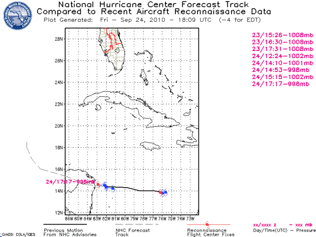
Anybody else see the elongation of Matt on visible.
Put this one in motion.

I could be wrong but it sure doesn't look like the center the recon found last is intact.
Put this one in motion.
I could be wrong but it sure doesn't look like the center the recon found last is intact.
0 likes
The following post is NOT an official forecast and should not be used as such. It is just the opinion of the poster and may or may not be backed by sound meteorological data. It is NOT endorsed by any professional institution including storm2k.org For Official Information please refer to the NHC and NWS products.
- TreasureIslandFLGal
- S2K Supporter

- Posts: 1584
- Age: 58
- Joined: Sun Aug 15, 2004 6:16 pm
- Location: Cancun, Mexico (northeast Yucatan coast)
-
Shuriken
-
Vortmax1
- Category 1

- Posts: 360
- Joined: Wed Jul 07, 2010 11:35 pm
- Location: Port Salerno, FL
- Contact:
any chance at a center relocation by Matt as the storm system gets disrupted over land?
There's a thread on that in Talkin Tropics:
viewtopic.php?f=31&t=109519
0 likes
Who is online
Users browsing this forum: No registered users and 68 guests


