
Pouch PGI50L in NW Carribean - Code Orange - (Is Invest 96L)
Moderator: S2k Moderators
Forum rules

The posts in this forum are NOT official forecasts and should not be used as such. They are just the opinion of the poster and may or may not be backed by sound meteorological data. They are NOT endorsed by any professional institution or STORM2K. For official information, please refer to products from the National Hurricane Center and National Weather Service.
-
cycloneye

- Admin

- Posts: 149275
- Age: 69
- Joined: Thu Oct 10, 2002 10:54 am
- Location: San Juan, Puerto Rico
Re: Hurricane possible NW carribean next week... Code Yellow
As AFM said, there has to be a focus point to then put the center for a invest to be up. I dont see a true central area yet,but that could change later today or tonight.
0 likes
Visit the Caribbean-Central America Weather Thread where you can find at first post web cams,radars
and observations from Caribbean basin members Click Here
and observations from Caribbean basin members Click Here
-
Air Force Met
- Military Met

- Posts: 4372
- Age: 57
- Joined: Tue Jul 08, 2003 9:30 am
- Location: Roan Mountain, TN
Re: Hurricane possible NW carribean next week... Code Yellow
GCANE wrote:The steering seems to indicate the gyre is in place.
Given the fact the core and LLC is still amazingly well structured, I think there is some chance he could circulate back into the Gulf of Honduras.
The LLC is not well structured. You need to take those satellite winds with a grain of salt...a very small grain of salt. There is no way the LLC looks like that.
0 likes
-
srainhoutx

- S2K Supporter

- Posts: 6919
- Age: 68
- Joined: Sun Jan 14, 2007 11:34 am
- Location: Haywood County, NC
- Contact:
Re: Hurricane possible NW carribean next week... Code Yellow
I suspect we will see a system strung out in a baroclinic fashion, once it develops and heads N/NE. Heavy rainfall will likekly be the main story from this feature IMO.
0 likes
Carla/Alicia/Jerry(In The Eye)/Michelle/Charley/Ivan/Dennis/Katrina/Rita/Wilma/Ike/Harvey
Member: National Weather Association
Wx Infinity Forums
http://wxinfinity.com/index.php
Facebook.com/WeatherInfinity
Twitter @WeatherInfinity
Member: National Weather Association
Wx Infinity Forums
http://wxinfinity.com/index.php
Facebook.com/WeatherInfinity
Twitter @WeatherInfinity
-
wxman57

- Moderator-Pro Met

- Posts: 23172
- Age: 68
- Joined: Sat Jun 21, 2003 8:06 pm
- Location: Houston, TX (southwest)
Re: Hurricane possible NW carribean next week... Code Yellow
Surface pressures are already quite low in the western Caribbean (1007-1009mb). Lowest pressure is north of Honduras/east of Belize. Banding is starting to show up on satellite imagery, and it's not Matthew's circulation. I'd say there's plenty there to initiate an invest. Development is looking likely, probably in 48-72 hrs. Northward track toward Florida and possibly into or along the East U.S. Coast seems like a good bet.
And I don't think this will be the last of the storms forming there. Low pressures will continue across the region. This may be the 2nd of 3 or 4 storms that form there over the next 2 weeks. Time for Florida's hurricane season.
And I don't think this will be the last of the storms forming there. Low pressures will continue across the region. This may be the 2nd of 3 or 4 storms that form there over the next 2 weeks. Time for Florida's hurricane season.
0 likes

Re: Hurricane possible NW carribean next week... Code Yellow
I see a possible center point at 83.9w and 17n with our new system.
http://www.ssd.noaa.gov/goes/east/watl/avn-l.jpg
http://www.ssd.noaa.gov/goes/east/watl/avn-l.jpg
0 likes
-
Vortmax1
- Category 1

- Posts: 360
- Joined: Wed Jul 07, 2010 11:35 pm
- Location: Port Salerno, FL
- Contact:
there has to be a focus point to then put the center for a invest to be up. I dont see a true central area yet,but that could change later today or tonight.
The focus point that I see would be right in the near shore waters off Nicaragua, Honduras.
I'm just loosely basing that off the upper streamlines.
But it looks like a likely area.
http://cimss.ssec.wisc.edu/tropic2/pred ... om=&time=0
0 likes
-
SouthFLTropics

- Category 5

- Posts: 4258
- Age: 50
- Joined: Thu Aug 14, 2003 8:04 am
- Location: Port St. Lucie, Florida
Re: Hurricane possible NW carribean next week... Code Yellow
wxman57 wrote:Surface pressures are already quite low in the western Caribbean (1007-1009mb). Lowest pressure is north of Honduras/east of Belize. Banding is starting to show up on satellite imagery, and it's not Matthew's circulation. I'd say there's plenty there to initiate an invest. Development is looking likely, probably in 48-72 hrs. Northward track toward Florida and possibly into or along the East U.S. Coast seems like a good bet.
And I don't think this will be the last of the storms forming there. Low pressures will continue across the region. This may be the 2nd of 3 or 4 storms that form there over the next 2 weeks. Time for Florida's hurricane season.
Thanks for the great news wxman...that's exactly what I wanted to hear...
In all seriousness I want to thank you for your input. Your points are always well taken and welcome and I highly respect your professionalism and opinion.
SFT
0 likes
Fourth Generation Florida Native
Personal Storm History: David 79, Andrew 92, Erin 95, Floyd 99, Irene 99, Frances 04, Jeanne 04, Wilma 05, Matthew 16, Irma 17, Ian 22, Nicole 22, Milton 24
Personal Storm History: David 79, Andrew 92, Erin 95, Floyd 99, Irene 99, Frances 04, Jeanne 04, Wilma 05, Matthew 16, Irma 17, Ian 22, Nicole 22, Milton 24
-
Air Force Met
- Military Met
- Posts: 4372
- Age: 57
- Joined: Tue Jul 08, 2003 9:30 am
- Location: Roan Mountain, TN
Re: Hurricane possible NW carribean next week... Code Yellow
GCANE wrote:NCEP ensembles seem to be tightening up on it.
If by it you mean Matthew...I will point out again what I pointed out over on the Matthew thread on Friday: The models are NOT seeing Matthew. It is a completely different system. These "connect the dots" sites just have a problem of always wanting to connect the dots and when they see two dots that are close to each other...and one was there first...it dissipates...then another forms to the east...well...they can't handle that issue to they "connect the dots" and that makes it look as if it is the same system moving/re-emerging and re-intensifying.
It's not. You have to actually look at what the models are telling you rather than the dots connected by the lines. That is what the HWRF was doing a couple of days ago. It created a broad low...with a dot of low pressure near Belize that was Matthew. Matthew dissipated. 12 hours later another dot of low pressure formed SW of the Caymans. It was completely separate. However...the HWRF graphic image connected the two dots and on the numerous web images and model images that are posted here...it appeared that the HWRF took Matthew off to the E of Belize and re-intensified it....which was not the case.
You actually have to look at the output of the models to see what they are saying. The plots are a good starting place...a tool...but you actually have to drill down and make sure that the plots make sense.
Also...looking at a high res vis look...I can say with certainty that the LLC of Matthew is pretty much done. That satellite wind image is about as much fiction as "Star Wars"
0 likes
-
hurricaneCW
- Category 5
- Posts: 1799
- Joined: Wed Mar 03, 2010 6:20 am
- Location: Toms River, NJ
Re: Hurricane possible NW carribean next week... Code Yellow
The gfs keeps everything off the coast after Florida. It looks like an unphased winter storm with the low staying offshore and giving areas further north no precipitation. Strong shot of chilly air though, big frosts for a lot of areas just inland in the Northeast.
0 likes
-
SouthFLTropics
- Category 5
- Posts: 4258
- Age: 50
- Joined: Thu Aug 14, 2003 8:04 am
- Location: Port St. Lucie, Florida
Re: Hurricane possible NW carribean next week... Code Yellow
boca wrote:I see a possible center point at 83.9w and 17n with our new system.
http://www.ssd.noaa.gov/goes/east/watl/avn-l.jpg
There may be a vort there but look further to the NW up near 86W and 18N and then step back and look at the BIG picture. Looks like banding extends all the way into the EPAC. 18N and 86W seems to be the emerging center of a VERY LARGE circulation.
SFT
0 likes
Fourth Generation Florida Native
Personal Storm History: David 79, Andrew 92, Erin 95, Floyd 99, Irene 99, Frances 04, Jeanne 04, Wilma 05, Matthew 16, Irma 17, Ian 22, Nicole 22, Milton 24
Personal Storm History: David 79, Andrew 92, Erin 95, Floyd 99, Irene 99, Frances 04, Jeanne 04, Wilma 05, Matthew 16, Irma 17, Ian 22, Nicole 22, Milton 24
-
Air Force Met
- Military Met
- Posts: 4372
- Age: 57
- Joined: Tue Jul 08, 2003 9:30 am
- Location: Roan Mountain, TN
Re: Hurricane possible NW carribean next week... Code Yellow
wxman57 wrote:Surface pressures are already quite low in the western Caribbean (1007-1009mb). Lowest pressure is north of Honduras/east of Belize. Banding is starting to show up on satellite imagery, and it's not Matthew's circulation. I'd say there's plenty there to initiate an invest. Development is looking likely, probably in 48-72 hrs. Northward track toward Florida and possibly into or along the East U.S. Coast seems like a good bet.
And I don't think this will be the last of the storms forming there. Low pressures will continue across the region. This may be the 2nd of 3 or 4 storms that form there over the next 2 weeks. Time for Florida's hurricane season.
I just looked at the satellite...and it is really coming together near 17.5/83. There is some really good mid level vorticity there.
I noticed the low pressures this morning. Cudos to the globals for seeing this pretty far in advance. I guess you and I are obsolete.
0 likes
-
wxman57
- Moderator-Pro Met
- Posts: 23172
- Age: 68
- Joined: Sat Jun 21, 2003 8:06 pm
- Location: Houston, TX (southwest)
Re: Hurricane possible NW carribean next week... Code Yellow
boca wrote:I see a possible center point at 83.9w and 17n with our new system.
http://www.ssd.noaa.gov/goes/east/watl/avn-l.jpg
That may not be a bad estimate. Here's a recent sat pic/surface plot. Not a lot of obs yet this hour, but the buoys point to something north of Honduras:

0 likes

Re: Hurricane possible NW carribean next week...
ericinmia wrote:Oh the drama...
I love how people can jump from "OMG THIS IS GOING TO BE INSANE" to... "Shows over..." in a matter of days, or handful of model runs. Wilma was pegged to be ripped apart on it's way to SFLa, up until just before the end... and that didn't occur, it became 'ventilated' by the shear. Whether this is a rain event or a "Big One!" as PREDICT had it lableled... lol... who knows. But let's just be here for the science, not the middle school drama and "oooooohhhh I need to make a comment, so I'm on record with my feeling of the hour" (pissing contest). Mind you, do you all notice the poor 'newbies' that come in and see these comments without disclaimers and get VERY confused? Let's all be a little more mature and topic appropriate.
To be Honest, for me: The "Storm Cancel" comments get old MUCH faster than the "OMG this is going to be insane..." ones.
Please remember to watch your wording and what you say, as people reading your thoughts may interpret them and think that you are "in the know" when in reality your just throwing comments out without a diploma or even concrete basis behind them. If you watch, even our wonderful MET's are very careful in their wording!
-Eric
Post like these get me irritated: mind you I have seen these every year for the past 6 years...and they still irritate me....
get over it! Its a message board. People can post whatever they want...doom, gloom or season over...whatever within the rules......
Last edited by ROCK on Sun Sep 26, 2010 9:06 am, edited 1 time in total.
0 likes


Re: Hurricane possible NW carribean next week... Code Yellow
There is a seperate circulation along the NE Honduran coast showing mostly at 700mb.
Given steering for it is to the north, that could be the kicker to spin this area up.
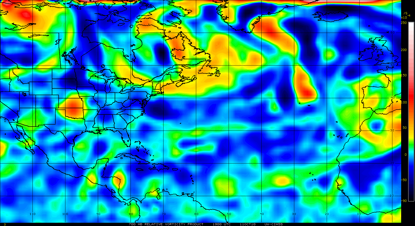
Given steering for it is to the north, that could be the kicker to spin this area up.
0 likes
Re: Hurricane possible NW carribean next week...
ROCK wrote:
Post like these get me irritated: mind you I have seen these every year for the past 6 years...and they still irritate me....
get over it! Its a message board. People can post whatever they want...doom, gloom or season over...whatever within the rules......
Obviously you don't get the points... (I am going to say this only once, because it's not worth my time to keep responding.)
1.) If people are making statements that are misleading 'newbies' and guests "without disclaimers"... that at least used to be against the rules of Storm2k.
2.) I've been on here for 7 years+, and have seen quite a lot. People need reminders that we are here to debate the storm and atmospheric dynamics... not to try and wittle through 100 "OMG Storm Cancel"/"We're going to all be DESTROYED" posts. A learning environment diluted with noise and drama is not really conducive.
If you took offense at my statement then that sounds like a personal problem. If you want to, I can get PM's.
(BTW there is no 1st ammendment here, this isn't a democracy... This post could even be deleted, without recourse.)
Back to the weather...
0 likes
Re: Hurricane possible NW carribean next week... Code Yellow
http://cimss.ssec.wisc.edu/tropic2/real ... oom=&time=
shear zone working down towards the coast and GOM...
shear zone working down towards the coast and GOM...
0 likes
-
Air Force Met
- Military Met
- Posts: 4372
- Age: 57
- Joined: Tue Jul 08, 2003 9:30 am
- Location: Roan Mountain, TN
Re:
gatorcane wrote:Thanks for the arguments folks but let's get back on topic please
I concur....please take your spat to our wonderful PM service...or I will be forced to do it for you
0 likes


Who is online
Users browsing this forum: Ulf and 169 guests