FireRat wrote:Looking through records, there are some antique analog storms of note that kind of portray what could happen should there be a worse case scenario in the two weeks ahead. The hurricane of late September, 1896 which took shape in the Caribbean and hooked NE into the Big bend. 1873's cat 3 storm that existed as a TS south of Cuba late September, grazed the Yucatan's northeast corner and then took a Wilma-like swipe at South Florida in early October. The worst of the three such storms was the infamous 1846 hurricane that barreled up through Cuba and up the spine of Florida on October 11 and then shot up the eastern U.S. seaboard. That one was possibly category 5 when it passed in the vicinity of the Keys. Bottom line, these close-to-home brew storms can once in a while be real monsters and whatever forms down there merits special attention. Just thought looking to the far past might reveal some long hidden secrets.
-FireRat.
Pouch PGI50L in NW Carribean - Code Orange - (Is Invest 96L)
Moderator: S2k Moderators
Forum rules

The posts in this forum are NOT official forecasts and should not be used as such. They are just the opinion of the poster and may or may not be backed by sound meteorological data. They are NOT endorsed by any professional institution or STORM2K. For official information, please refer to products from the National Hurricane Center and National Weather Service.
Re: Pouch PGI50L in NW Carribean - Code Yellow
Great info...but as we saw with Wilma, sustained Cat 1/isolated low end Cat 2 winds across an area with 6 million+ plus from Miami-Dade county north through Fort Lauderdale and into West Palm...was all it took to make Wilma the 3rd costliest storm in U.S. history....and i can say personally, after being without power for 13 days from that event, it was a memorable storm!!!
0 likes

Re: Pouch PGI50L in NW Carribean - Code Yellow
Wilma was truly amazing, we were lucky it didn't get us with real major hurricane intensity. I remember that thing like it were yesterday. I rode it out with my family in Sunrise and was able to see the whole thing unfold as there was a 3 inch space between our metal shutters that protected the porch sliding door of my uncle's south facing, 3 window apartment. We even had to press a mattress against the doggone thing just to keep it from bending inwards, the outside awnings broke free and twisted around the palms, roof tiles flying through the air like slingshot ammo into car windows right before our eyes...and of course the 98% county-wide power failure...and all that from a Cat 2!
Those 19th century storms would have truly whooped us had they hit today.
Those 19th century storms would have truly whooped us had they hit today.
0 likes
Georges '98, Irene '99, Frances '04, Jeanne '04, Katrina '05, Wilma '05, Gustav '08, Isaac '12, Matthew '16, Florence '18, Michael '18, Ian '22
-
Shuriken
Re: Pouch PGI50L in NW Carribean - Code Yellow
http://en.wikipedia.org/wiki/1924_Cuba_hurricaneFireRat wrote:Looking through records, there are some antique analog storms of note that kind of portray what could happen should there be a worse case scenario in the two weeks ahead. The hurricane of late September, 1896 which took shape in the Caribbean and hooked NE into the Big bend. 1873's cat 3 storm that existed as a TS south of Cuba late September, grazed the Yucatan's northeast corner and then took a Wilma-like swipe at South Florida in early October. The worst of the three such storms was the infamous 1846 hurricane that barreled up through Cuba and up the spine of Florida on October 11 and then shot up the eastern U.S. seaboard. That one was possibly category 5 when it passed in the vicinity of the Keys. Bottom line, these close-to-home brew storms can once in a while be real monsters and whatever forms down there merits special attention. Just thought looking to the far past might reveal some long hidden secrets.
-FireRat.

0 likes
Ahh yes the '24 Cuba hurricane....Cat 5, MAMA MIA!
October can surely bring monster hurricanes, by far the most active landfall month for Cuba and Florida. Thanks for the image Shuriken.
October can surely bring monster hurricanes, by far the most active landfall month for Cuba and Florida. Thanks for the image Shuriken.
0 likes
Georges '98, Irene '99, Frances '04, Jeanne '04, Katrina '05, Wilma '05, Gustav '08, Isaac '12, Matthew '16, Florence '18, Michael '18, Ian '22

Thanks FireRat for the info and welcome to S2K!
I see the history shown of "one shot deals" that hit South Florida back in the 1800's but have we ever seen what is one of the forecasts that is being shown by the models; a succession or train of TS's or Hurricanes coming through South Florida?
I am not referring to Francis and Jeanne since they were really not representative of training of storms.
I know that some models show a Nicole, Otto and even Paula coming through over about a 2 week period and that seems to me to be unprecedented. Even 2 in a row in a week might be a historical first
Any history on this type of wild occurrence?
0 likes
-
Andrew92

- S2K Supporter

- Posts: 3247
- Age: 42
- Joined: Mon Jun 16, 2003 12:35 am
- Location: Phoenix, Arizona
Re:
fci wrote:Thanks FireRat for the info and welcome to S2K!
I see the history shown of "one shot deals" that hit South Florida back in the 1800's but have we ever seen what is one of the forecasts that is being shown by the models; a succession or train of TS's or Hurricanes coming through South Florida?
I am not referring to Francis and Jeanne since they were really not representative of training of storms.
I know that some models show a Nicole, Otto and even Paula coming through over about a 2 week period and that seems to me to be unprecedented. Even 2 in a row in a week might be a historical first
Any history on this type of wild occurrence?
Well, in 1953, an unnamed tropical storm formed, moved over Cuba, brushed Florida, and rapidly went out to sea between October 3-7. On October 7, while that storm was on the way out, Tropical Storm Hazel (not to be confused with the famous North Carolina storm) developed near the Yucatan Channel and followed a remarkably similar path; except it moved through the Gulf of Mexico on its way to Florida. Hazel was also almost a hurricane when it blew over Florida. Like the unnamed storm, it too went out to sea after that. However, I don't find anything that came right after Hazel in 1953 from that area. I guess it's possible there could have been a depression that failed to become a tropical storm, but who knows?
-Andrew92
0 likes
Re: Pouch PGI50L in NW Carribean - Code Orange
Thanks for the welcome!
That I know, this would be a first to get two or more OCTOBER storms in a row striking the sunshine state. On the other hand, this month has been infamous for some severe barrages in the past. I think the best example of such a wild October was in 1780, where the Savanna La mar hurricane devastated Jamaica on the 3rd and went up through Cuba the day after, and was quickly followed by the Great Hurricane on the 10th smashing through the Lesser Antilles as Cat 5, and then with a Gulf storm known as Solano's hurricane forming near Jamaica on the 15th before entering the Gulf on the 20th where it sank many ships at a likely intense state before crashing through North Florida and dissipating by the 25th. That hurricane season was in my opinion the big one, it was the deadliest ever for the Atlantic and all due to those 3 killer October storms, where the Great Hurricane alone took 22,000 lives!
That I know, this would be a first to get two or more OCTOBER storms in a row striking the sunshine state. On the other hand, this month has been infamous for some severe barrages in the past. I think the best example of such a wild October was in 1780, where the Savanna La mar hurricane devastated Jamaica on the 3rd and went up through Cuba the day after, and was quickly followed by the Great Hurricane on the 10th smashing through the Lesser Antilles as Cat 5, and then with a Gulf storm known as Solano's hurricane forming near Jamaica on the 15th before entering the Gulf on the 20th where it sank many ships at a likely intense state before crashing through North Florida and dissipating by the 25th. That hurricane season was in my opinion the big one, it was the deadliest ever for the Atlantic and all due to those 3 killer October storms, where the Great Hurricane alone took 22,000 lives!
0 likes
Georges '98, Irene '99, Frances '04, Jeanne '04, Katrina '05, Wilma '05, Gustav '08, Isaac '12, Matthew '16, Florence '18, Michael '18, Ian '22
-
jlauderdal
- S2K Supporter
- Posts: 7240
- Joined: Wed May 19, 2004 5:46 am
- Location: NE Fort Lauderdale
- Contact:
Re: Pouch PGI50L in NW Carribean - Code Orange
it appears we have the setup to efficiently take advantage of this " PRECIPITABLE WATERS AVERAGE IN EXCESS OF 2.75
INCHES THROUGH THIS PERIOD"...
INCHES THROUGH THIS PERIOD"...
0 likes
-
jlauderdal
- S2K Supporter
- Posts: 7240
- Joined: Wed May 19, 2004 5:46 am
- Location: NE Fort Lauderdale
- Contact:
Re: Pouch PGI50L in NW Carribean - Code Yellow
boca wrote:Evil Jeremy wrote:jinftl wrote:As an FYI/reality check....i haven't seen any media coverage of anything regarding what may develop other than a mention that the rain chances may go up later this week during the weather segment of the news....this from a local news media that is hyper-sensitive to anything even remotely suggesting a 'tropical threat' to south florida.
The dialogue here has not yet made the maintstream news....nor should it...yet.
I wish I still got wsvn here in boca. they dropped it out of their lineup 5 yrs ago.
you can watch the WSVN newscasts live, enjoy..
http://www.wsvn.com/video/live/
0 likes
-
ColinDelia

- S2K Supporter
- Posts: 918
- Joined: Mon Aug 29, 2005 5:52 am
- Location: The Beach, FL
6z GFS
24 hours. 1003 mb low in NW Caribbean
42 hours. 998 mb. Over Isle of Youth
48 hours. 998 mb. Over Cuba
54-60 hours. 997 mb. Florida Straits
66 hours. 997 mb. East of St. Augustine, FL
72 hours. 994 mb. East of Georgia
78 hours. 994 mb. On Carolina coast near NC/SC border
84 hours. 995 mb. Over eastern Virginia
90 hours. 994 mb. Over Long Island
Notes ...
Storm II. There is a 999 mb low over SE Florida at 72 hours.
Storm III. There is a separate and distinct 1005 mb low near SE Florida/Bahamas at 90 hours
Storm IV. There is a 1005 MB low in NW Caribbean at 96 hours which is still in the NW Caribbean at 120 hours as a 1002 mb low. This one moves very slow and is over Cuba still at 174 hours. Then it move South back into the Caribbean! And finally heading North over Cuba at 324 hours and over the western Bahamas. Heh, if that verifies I'll well, I'll eat my hat.
4 storms in the next 5 days?! Interesting set-up regardless of what happens
Last edited by ColinDelia on Mon Sep 27, 2010 5:42 am, edited 1 time in total.
0 likes
Re: Pouch PGI50L in NW Carribean - Code Orange
I find it odd that this area was raised to Code Orange but we don't have a formal invest named?
0 likes


Re: Pouch PGI50L in NW Carribean - Code Orange
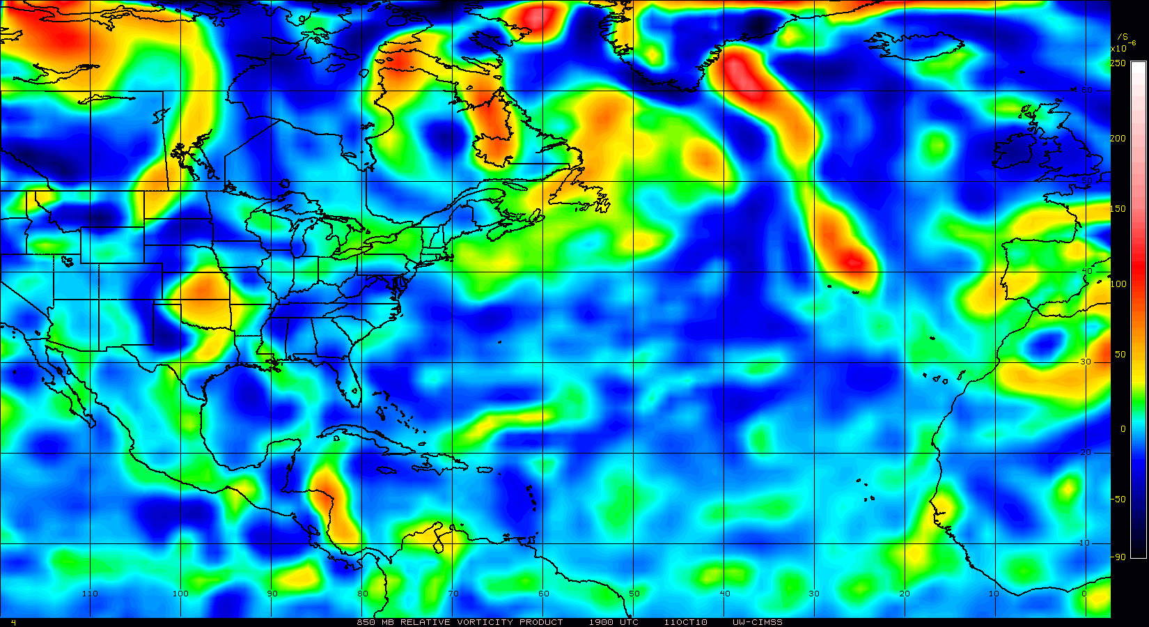
It looks like the models pegged the 850mb vorticity forecast.
It looks nearly exactly like what they were showing last Thursday / Friday for this time.
Convection is topping out at 55 to 60K-ft in some very large cells.
A really good looking poleward outflow channel is nicely setup.
Very high CAPE in the area.
With the low-pressures at the two West-Carib Buoys, this should ramp up quickly.
0 likes

-
Aquawind

- Category 5

- Posts: 6714
- Age: 62
- Joined: Mon Jun 16, 2003 10:41 pm
- Location: Salisbury, NC
- Contact:
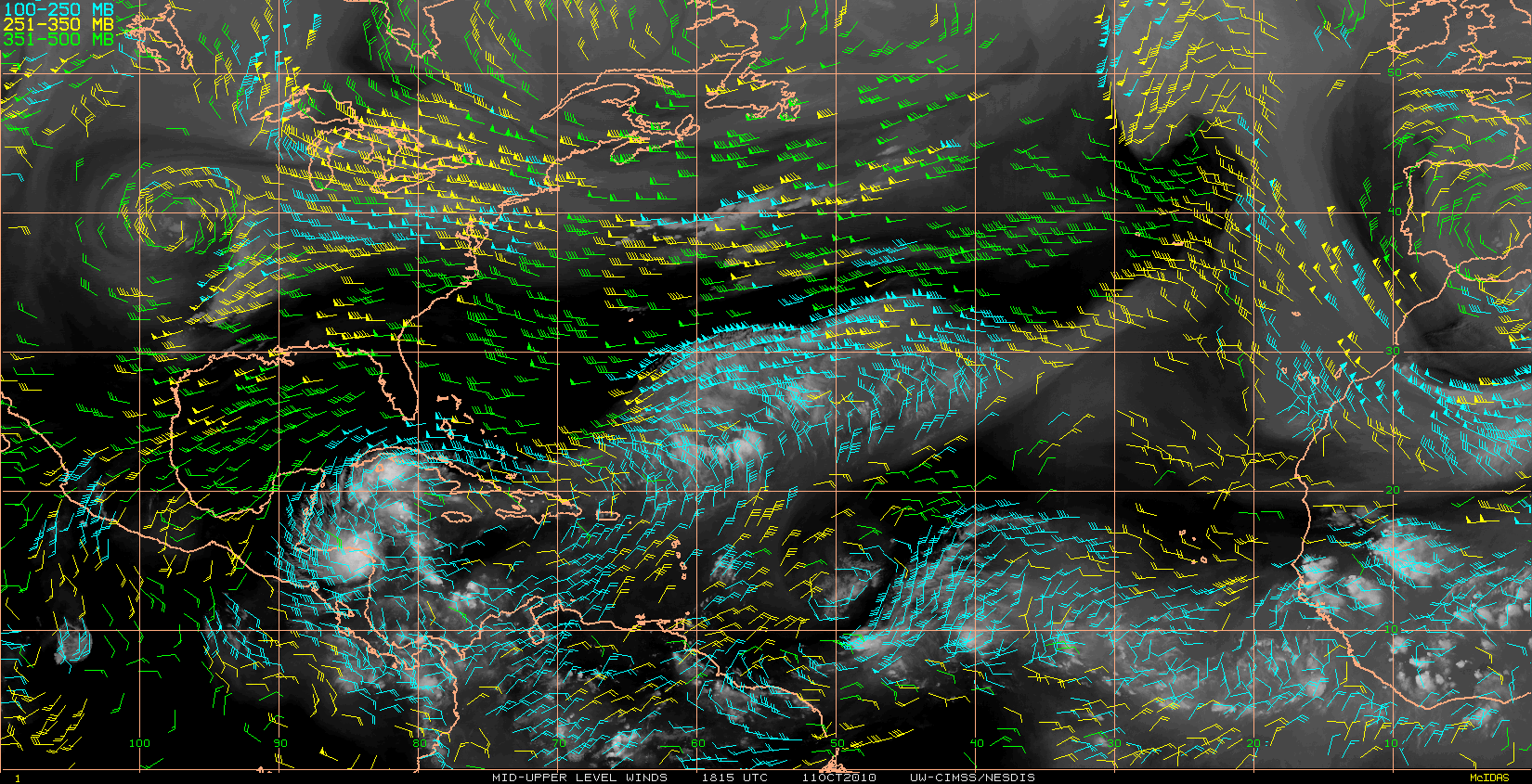
West of the Cayman Islands we have good vorticity stacked at 850, 700, 500mb and LL Divergence. UL divergence and even lower shear..
http://cimss.ssec.wisc.edu/tropic2/real ... oom=&time=
http://cimss.ssec.wisc.edu/tropic2/real ... oom=&time=
Last edited by Aquawind on Mon Sep 27, 2010 5:59 am, edited 1 time in total.
0 likes
-
tolakram
- Admin

- Posts: 20178
- Age: 62
- Joined: Sun Aug 27, 2006 8:23 pm
- Location: Florence, KY (name is Mark)
Re: Pouch PGI50L in NW Carribean - Code Orange
The posts in this forum are NOT official forecast and should not be used as such. They are just the opinion of the poster and may or may not be backed by sound meteorological data. They are NOT endorsed by any professional institution or storm2k.org. For official information, please refer to the NHC and NWS products.
I think we're looking at a sheared messy system that might be tropical moving over or just south of Florida and then out to sea. Honestly this looks more like a northeaster than a tropical storm.
Shear Tendency:

GFS Shear Forecast for 72 hours:

From my amateur point of of view the tropics are starting to look pretty unfavorable pretty fast. Of course shear forecasts are almost always wrong and things can change quickly in the tropics ....
I think we're looking at a sheared messy system that might be tropical moving over or just south of Florida and then out to sea. Honestly this looks more like a northeaster than a tropical storm.
Shear Tendency:
GFS Shear Forecast for 72 hours:
From my amateur point of of view the tropics are starting to look pretty unfavorable pretty fast. Of course shear forecasts are almost always wrong and things can change quickly in the tropics ....
Last edited by tolakram on Mon Sep 27, 2010 7:35 am, edited 1 time in total.
0 likes
M a r k
- - - - -
Join us in chat: Storm2K Chatroom Invite. Android and IOS apps also available.
The posts in this forum are NOT official forecasts and should not be used as such. Posts are NOT endorsed by any professional institution or STORM2K.org. For official information and forecasts, please refer to NHC and NWS products.
Re: Pouch PGI50L in NW Carribean - Code Orange
Looks like current steering is along a NNW direction.
SREF shows the cutoff-low currently over Memphis lifting out in the next 36 to 48 hrs.
Another cutoff-low is forecast to form in about 72 hrs over MS / AL although not as deep.


SREF shows the cutoff-low currently over Memphis lifting out in the next 36 to 48 hrs.
Another cutoff-low is forecast to form in about 72 hrs over MS / AL although not as deep.
0 likes
Re: Pouch PGI50L in NW Carribean - Code Orange
The whole gyre could fire off 2 or 3 systems per CMC and GFS.
NCEP ensembles are sticking with two.
Euro seems to be sticking with one and with a track more to the west.
http://moe.met.fsu.edu/cgi-bin/gfstc2.c ... =Animation
http://moe.met.fsu.edu/cgi-bin/cmctc2.c ... =Animation


NCEP ensembles are sticking with two.
Euro seems to be sticking with one and with a track more to the west.
http://moe.met.fsu.edu/cgi-bin/gfstc2.c ... =Animation
http://moe.met.fsu.edu/cgi-bin/cmctc2.c ... =Animation
0 likes
Who is online
Users browsing this forum: JoshwaDone, Teban54, USTropics and 79 guests