Nice SST image by NASA
Moderator: S2k Moderators


Dean4Storms wrote:Good point, I was thinking the ridge behind the front was much stronger than 1012, but I went back and looked at the surface forecast and you are correct. Thanks!


artist wrote:S TAT E O F F L O R I D A
D I V I S I O N O F E M E R G E N C Y M A N A G E M E N T
CHARLIE CRIST
Governor
DAVID HALSTEAD
Director
F L O R I D A R E C O V E R Y O F F I C E • D I V I S I O N H E A D Q U A R T E R S • STATE LOGISTICS RESPONSE CENTER
3 6 Sk yl i ne Dr i v e 2 5 5 5 S h uma r d Oa k B o u l e v a r d 2 70 2 Di r ec t o r s Row
L ak e Ma r y, FL 32 7 4 6 - 6 2 01 T a l l a h a s s e e , F L 3 2 3 9 9 - 2 1 0 0 Or l an d o, FL 3 2 80 9 - 56 3 1
Tel : 850-413- 9 9 6 9 • Fax: 850 -488-1016
http://www.Fl or i daDisaster .org
FOR IMMEDIATE RELEASE CONTACT: PUBLIC INFORMATION
FRIDAY, SEPTEMBER 24, 2010 (850) 413-9969
http://www.FloridaDisaster.org
FLORIDA EMERGENCY MANAGERS ENCOURAGE ALL RESIDENTS AND VISITORS TO
MONITOR TROPICAL DEVELOPMENTS THIS WEEKEND
http://www.floridadisaster.org/eoc/Pres ... 202010.pdf
Apologies for straying a bit off topic but apparently a single thunderstorm can produce rainfall of that order. Look at what happened on September 8, 1872 in Barbados.canes04 wrote:I live in Doral and it floods here with an afternoon thunderstorm.
Can't imagine if we get 8 to 12 inched of rain. Guess I would need to keep a lookout for Gators im my yard.
Anyway, if this develops an LLC today look out.

wxman57 wrote:Dean4Storms wrote:Good point, I was thinking the ridge behind the front was much stronger than 1012, but I went back and looked at the surface forecast and you are correct. Thanks!
Of course, the above discussion makes the big assumption that the GFS' prediction of a 996mb low is correct. Given the short time for development, though, it may not be far off. I still cannot identify any LLC on satellite. Surface obs suggest something may be located just east of the Yucatan southeast of Cozumel.


HURAKAN wrote:
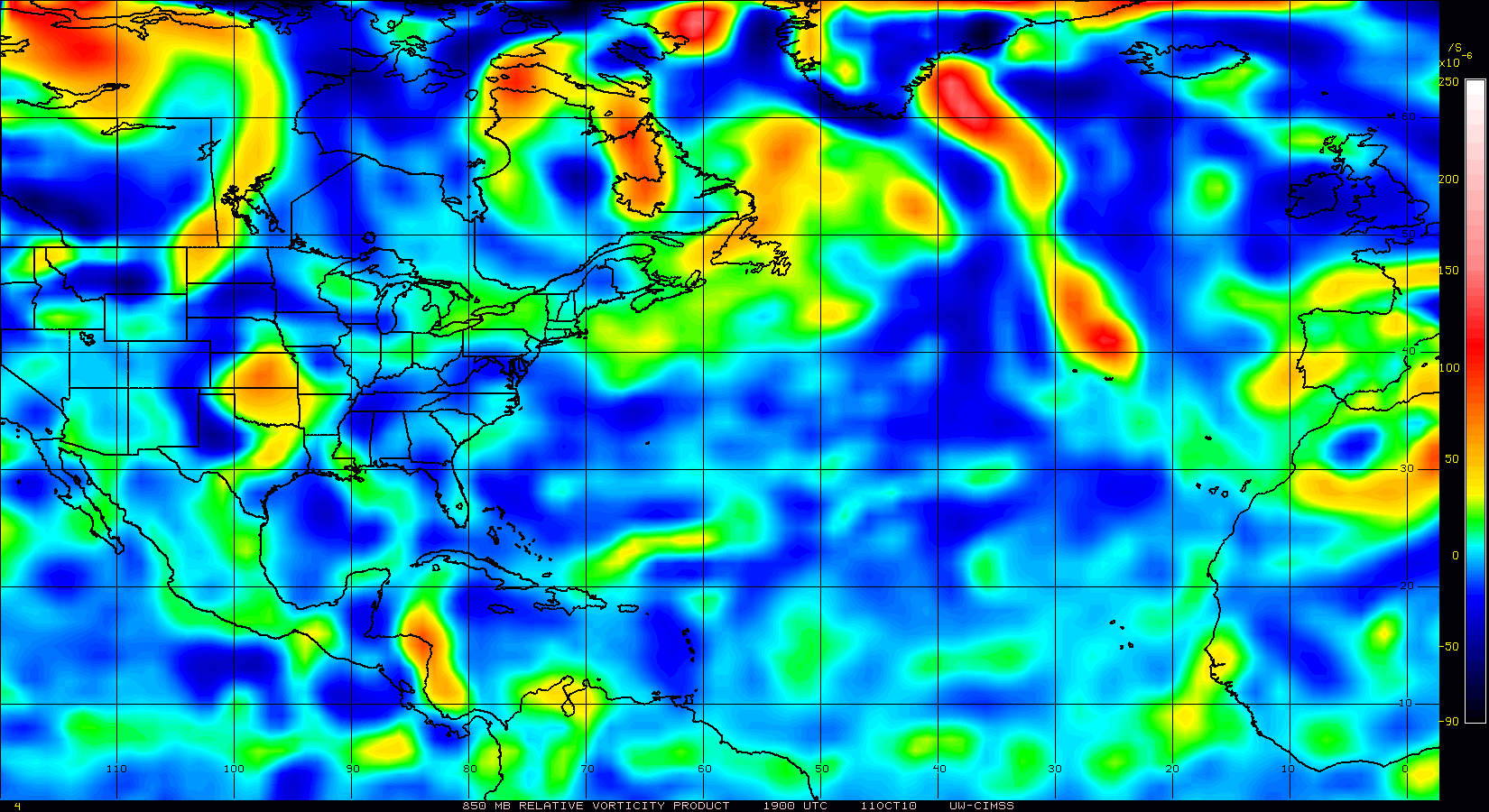
Vorticity keeps increasing


Code: Select all
000
NOUS42 KNHC 271630
WEATHER RECONNAISSANCE FLIGHTS
CARCAH, NATIONAL HURRICANE CENTER, MIAMI, FL.
1230 PM EDT MON 27 SEPTEMBER 2010
SUBJECT: TROPICAL CYCLONE PLAN OF THE DAY (TCPOD)
         VALID 28/1100Z TO 29/1100Z SEPTEMBER 2010
         TCPOD NUMBER.....10-118

I.   ATLANTIC REQUIREMENTS
     1. SUSPECT SYSTEM (NORTHWEST CARIBBEAN)
        FLIGHT ONE -- TEAL 70
        A. 28/1800Z
        B. AFXXX 01GGA INVEST
        C. 28/1530Z
        D. 20.0N 85.0W
        E. 28/1700Z TO 28/2300Z
        F. SFC TO 10,000 FT

        FLIGHT TWO -- TEAL 71
        A. 29/0600,1200Z
        B. AFXXX 0216A CYCLONE
        C. 29/0315Z
        D. 21.5N 84.5W
        E. 29/0500Z TO 29/1200Z
        F. SFC TO 15,000 FT

     2. SUCCEEDING DAY OUTLOOK:
        BEGIN 3-HRLY FIXES AT 29/1500Z IF SYSTEM DEVELOPS.

     3. TASKING FOR AF AND G-IV MISSIONS AT 28/1800Z, 29/06
        AND 1200Z WERE CANX BY NHC AT 1115Z.

     3. REMARK: THE NSF/NCAR G-V WILL FLY A 7 HR RESEARCH
        MISSION INTO AND AROUND THE SUSPECT AREA BETWEEEN
        41,000 AND 43,000 FT WITH TAKEOFF AT 28/1200Z.


ObsessedMiami wrote:artist wrote:S TAT E O F F L O R I D A
D I V I S I O N O F E M E R G E N C Y M A N A G E M E N T
CHARLIE CRIST
Governor
DAVID HALSTEAD
Director
F L O R I D A R E C O V E R Y O F F I C E • D I V I S I O N H E A D Q U A R T E R S • STATE LOGISTICS RESPONSE CENTER
3 6 Sk yl i ne Dr i v e 2 5 5 5 S h uma r d Oa k B o u l e v a r d 2 70 2 Di r ec t o r s Row
L ak e Ma r y, FL 32 7 4 6 - 6 2 01 T a l l a h a s s e e , F L 3 2 3 9 9 - 2 1 0 0 Or l an d o, FL 3 2 80 9 - 56 3 1
Tel : 850-413- 9 9 6 9 • Fax: 850 -488-1016
http://www.Fl or i daDisaster .org
FOR IMMEDIATE RELEASE CONTACT: PUBLIC INFORMATION
FRIDAY, SEPTEMBER 24, 2010 (850) 413-9969
http://www.FloridaDisaster.org
FLORIDA EMERGENCY MANAGERS ENCOURAGE ALL RESIDENTS AND VISITORS TO
MONITOR TROPICAL DEVELOPMENTS THIS WEEKEND
http://www.floridadisaster.org/eoc/Pres ... 202010.pdf
That is from Friday. They haven't updated it, have they?

hurricaneCW wrote:A lot of hype for well over a week, but the end result will only be a sheared TS. Of course that's only for the first Caribbean system, who knows what future systems could do.
The whole pattern does look like a prime recipe for early autumn noreasters with a bit of a tropical kick to them meaning much more moisture than usual. After the first storm is gone, the gfs takes the next storm on a similar track with similar intensity through Florida and up the coast once again. Then at the end up the run, we have another Caribbean low developing.
If anyone wants a strong storm to form, the pattern would have to change from that strong and broad eastern trough to a broad ridge. That way the upper level environment would be far more favorable and the storms would enter the gulf of mexico rather than Florida and up the coast.


dwsqos2 wrote:I am going to laugh if whatever comes of this isn't classified. Of course, Barry of 2007 was, so this probably will marginally meet the definition of tc.
TreasureIslandFLGal wrote:Is that matthew's remnant low about to enter into the BOC? Still showing a strong vorticity there. With weak steering currents, that could fester in the BOC until the next low dips down in a few days. -or is it pegged to head further west and remain over land?
Users browsing this forum: cycloneye and 158 guests