ATL: NICOLE - Ex Tropical Storm - Discussion

Moderator: S2k Moderators

Message
Author
User avatar
HURAKAN
Professional-Met
Professional-Met
Posts: 46086
Age: 38
Joined: Thu May 20, 2004 4:34 pm
Location: Key West, FL
Contact:

#361 Postby HURAKAN » Tue Sep 28, 2010 7:40 am

Code: Select all

DADD - MARITIME-ship
Tuesday Sep. 28 - 12:00 UTC
Air Temperature: 83°F
Dewpoint: 76°F
Wind: SSW at 34 mph
Pressure: 1003 mb
Weather: Cloudy
Wave Height: 13 ft
Sea Surface Temp: 86°F


Aqua, this is another ship further east
0 likes   

User avatar
Aquawind
Category 5
Category 5
Posts: 6714
Age: 62
Joined: Mon Jun 16, 2003 10:41 pm
Location: Salisbury, NC
Contact:

Re:

#362 Postby Aquawind » Tue Sep 28, 2010 7:42 am

HURAKAN wrote:

Code: Select all

DADD - MARITIME-ship
Tuesday Sep. 28 - 12:00 UTC
Air Temperature: 83°F
Dewpoint: 76°F
Wind: SSW at 34 mph
Pressure: 1003 mb
Weather: Cloudy
Wave Height: 13 ft
Sea Surface Temp: 86°F


Aqua, this is another ship further east


The Data is much more realistic.. unless thats a Arctic front that passed the other bouy..lol
0 likes   

Aric Dunn
Category 5
Category 5
Posts: 21238
Age: 42
Joined: Sun Sep 19, 2004 9:58 pm
Location: Ready for the Chase.
Contact:

Re: Re:

#363 Postby Aric Dunn » Tue Sep 28, 2010 7:45 am

Aquawind wrote:
HURAKAN wrote:

Code: Select all

DADD - MARITIME-ship
Tuesday Sep. 28 - 12:00 UTC
Air Temperature: 83°F
Dewpoint: 76°F
Wind: SSW at 34 mph
Pressure: 1003 mb
Weather: Cloudy
Wave Height: 13 ft
Sea Surface Temp: 86°F


Aqua, this is another ship further east


The Data is much more realistic.. unless thats a Arctic front that passed the other bouy..lol


you have to remember that it all depends on where the ships equipment is placed.. the anemometer is likely more realistic than the temp and dew point especially if it is places near the stack or the cabin which may have AC. you would think they would have everything on a mast of some sort but it may not be the case..
Last edited by Aric Dunn on Tue Sep 28, 2010 7:46 am, edited 1 time in total.
0 likes   
Note: If I make a post that is brief. Please refer back to previous posts for the analysis or reasoning. I do not re-write/qoute what my initial post said each time.
If there is nothing before... then just ask :)

Space & Atmospheric Physicist, Embry-Riddle Aeronautical University,
I believe the sky is falling...

User avatar
HURAKAN
Professional-Met
Professional-Met
Posts: 46086
Age: 38
Joined: Thu May 20, 2004 4:34 pm
Location: Key West, FL
Contact:

#364 Postby HURAKAN » Tue Sep 28, 2010 7:45 am

Loop - http://wwwghcc.msfc.nasa.gov/GOES/goeseastconus.html

Very close inspection seems like there a LLC developing or develop between Isla de la Juventud and Cayman Islands
0 likes   

User avatar
srainhoutx
S2K Supporter
S2K Supporter
Posts: 6919
Age: 67
Joined: Sun Jan 14, 2007 11:34 am
Location: Haywood County, NC
Contact:

Re: ATL : INVEST 96L - Discussion

#365 Postby srainhoutx » Tue Sep 28, 2010 7:45 am

From Miami/Ft Lauderdale...

CURRENT WATER VAPOR IMAGERY DEPICTS TROPICAL MOISTURE STREAMING
UP THE FLORIDA PENINSULA AND OFF THE SOUTHEAST U.S. COAST. A
PESKY UPPER LOW IS CENTERED OVER THE OHIO VALLEY...WITH A COLD
FRONT TRAILING INTO NORTH FLORIDA. MEANWHILE...AN AREA OF LOW
PRESSURE CONTINUES TO FORM SOUTH OF CUBA AND WILL ALLOW
CONSIDERABLE DEEP MOISTURE TO CONTINUE PUSHING NORTH...WITH FIRST
SIGNIFICANT IMPACTS ON SOUTH FLORIDA THIS AFTERNOON.

MODEL GUIDANCE SUGGESTS SCATTERED SHOWERS AND THUNDERSTORMS WILL
BECOME WIDESPREAD AND LOCALLY HEAVY BY LATE IN THE DAY. IT IS
INTERESTING TO NOTE THAT THE GFS AND ECMWF HAVE SHIFTED EVEN A
BIT FARTHER EAST WITH THE AXIS OF HEAVIEST RAINFALL...WHICH WOULD
IMPACT ONLY THE IMMEDIATE EAST COAST. MEANWHILE...THE NAM HAS
BECOME WETTER AND ALSO KEEPS THE HEAVIEST PRECIPITATION FARTHER
WEST...WHERE IT IMPACTS MUCH OF THE PENINSULA INCLUDING AT LEAST
THE WEST COAST FOR SEVERAL HOURS. NAM12 FORECAST SOUNDINGS FOR
MIAMI INDICATE PRECIPITABLE WATERS APPROACHING 2.5 INCHES BY 21Z
TODAY...RISING TO 2.75 INCHES BY 08Z TONIGHT. WHILE THESE AMOUNTS
ARE EXTREMELY IMPRESSIVE...THEY ARE A BIT LOWER THAN THOSE
FORECAST 24 HOURS AGO. SHOWER COVERAGE AND INTENSITY WILL
CERTAINLY BE ON THE INCREASE BY EVENING AS LOW LEVEL
SOUTHEASTERLY FLOW RESULTS IN STRONG CONVERGENCE ALONG AND TO THE
SOUTH OF THE STALLED FRONTAL BOUNDARY OVER CENTRAL FLORIDA. GIVEN
THE COPIOUS AMOUNT OF MOISTURE...DEEP SATURATION THROUGH H4...AND
THE POTENTIAL FOR LINEAR BANDS OF VERY HEAVY RAINFALL...FLOODING
IS A CONCERN. THE HEAVIER BANDS OF RAINFALL MAY BECOME TRAINED
OVER THE SAME LOCALES...WITH RAINFALL RATES IN EXCESS OF 2 INCHES
PER HOUR QUITE POSSIBLE.

THE MOST WIDESPREAD AND HEAVIEST RAINFALL IS ANTICIPATED LATE
THIS EVENING THROUGH WEDNESDAY MORNING...WITH THE AXIS OF DEEP
MOISTURE THEN PUSHING OFF THE EAST COAST BY 18Z WEDNESDAY.
RAINFALL AMOUNTS OF 3 TO 5 INCHES ARE POSSIBLE ALONG THE EAST
COAST INCLUDING THE METRO AREAS...WITH LOCALLY HIGHER AMOUNTS. 2
TO 4 INCHES OF RAINFALL IS EXPECTED ELSEWHERE IN THE WATCH AREA.
GLADES AND HENDRY COUNTIES MAY SEE 1 TO 3 INCHES - A HYDROLOGIC
OUTLOOK (ESF) WAS CONTINUED FOR THIS AREA.

IT SHOULD BE NOTED THAT THE TRACK AND FORWARD SPEED OF THE MID-
UPPER LEVEL LOW ACROSS THE OHIO VALLEY...ALONG WITH ITS DIGGING
TROUGH...WILL BE CRITICAL IN DETERMINING IF THE AXIS OF HEAVIEST
RAINFALL TRAVELS ACROSS SOUTH FLORIDA...OR TO THE EAST OVER THE
ATLANTIC. ADDITIONALLY...IF THE FRONTAL BOUNDARY STALLS FARTHER
TO THE EAST...MUCH OF THE HEAVIEST RAINFALL WILL CERTAINLY BE
PUSHED OFF THE MAINLAND.

CONDITIONS WILL BEGIN TO IMPROVE BY LATE WEDNESDAY AFTERNOON AS
THE LOW BEGINS TO PULL NORTHEAST AND PRECIPITABLE WATERS QUICKLY
FALL AS DRIER ALOFT ARRIVES FROM THE NORTH.

FORECAST REMAINS HIGHLY UNCERTAIN FOR THE END OF THE WEEK AS
ANOTHER TROPICAL CYCLONE MAY TRY TO FORM IN THE NORTHWEST
CARIBBEAN AND LIFT NORTH TOWARD SOUTH FLORIDA SATURDAY OR SUNDAY.
AT THIS TIME...WE OPTED TO MAKE FEW CHANGES TO THE EXTENDED
FORECAST AND AWAIT BETTER MODEL CONTINUITY AND AGREEMENT.
0 likes   
Carla/Alicia/Jerry(In The Eye)/Michelle/Charley/Ivan/Dennis/Katrina/Rita/Wilma/Ike/Harvey

Member: National Weather Association
Wx Infinity Forums
http://wxinfinity.com/index.php

Facebook.com/WeatherInfinity
Twitter @WeatherInfinity

User avatar
Aquawind
Category 5
Category 5
Posts: 6714
Age: 62
Joined: Mon Jun 16, 2003 10:41 pm
Location: Salisbury, NC
Contact:

Re: ATL : INVEST 96L - Discussion

#366 Postby Aquawind » Tue Sep 28, 2010 7:48 am

you have to remember that it all depends on where the ship the equipment is placed.. the anemometer is likely more realistic than the temp and dew point especially it is places near the stack or the cabin which may have AC. you would think they would have everything on a mast of some sort but it may not be the case..


Water Temps as well...so whatever from that prior report.. The captain probably has instruments right above his toilet..sheesh..and yes he had chilli frof dinner so it's a bit breezy in there..
0 likes   

User avatar
HURAKAN
Professional-Met
Professional-Met
Posts: 46086
Age: 38
Joined: Thu May 20, 2004 4:34 pm
Location: Key West, FL
Contact:

#367 Postby HURAKAN » Tue Sep 28, 2010 7:54 am

28/1145 UTC 21.0N 82.8W ST1.5 96L

ST, interesting
0 likes   

tolakram
Admin
Admin
Posts: 20009
Age: 62
Joined: Sun Aug 27, 2006 8:23 pm
Location: Florence, KY (name is Mark)

Re: ATL : INVEST 96L - Discussion

#368 Postby tolakram » Tue Sep 28, 2010 7:58 am

The posts in this forum are NOT official forecast and should not be used as such. They are just the opinion of the poster and may or may not be backed by sound meteorological data. They are NOT endorsed by any professional institution or storm2k.org. For official information, please refer to the NHC and NWS products.


I still stand by my statement that this may never become fully tropical and might never even be sub tropical. Looking at the models and the signature of the low pressure (an oblong blob) this does not have a tropical look to it. I agree that tropical influences are at work creating the low pressure center, but it appears to me it will rapidly merge with the front and be more like a nor'easter.

This pattern does not look La Nina like ... but we do have the entire month of October left.
0 likes   
M a r k
- - - - -
Join us in chat: Storm2K Chatroom Invite. Android and IOS apps also available.

The posts in this forum are NOT official forecasts and should not be used as such. Posts are NOT endorsed by any professional institution or STORM2K.org. For official information and forecasts, please refer to NHC and NWS products.

User avatar
SouthFloridawx
S2K Supporter
S2K Supporter
Posts: 8346
Age: 46
Joined: Tue Jul 26, 2005 1:16 am
Location: Sarasota, FL
Contact:

Re: ATL : INVEST 96L - Discussion

#369 Postby SouthFloridawx » Tue Sep 28, 2010 8:02 am

Does it look like the front is stalling out?

Image
0 likes   

User avatar
srainhoutx
S2K Supporter
S2K Supporter
Posts: 6919
Age: 67
Joined: Sun Jan 14, 2007 11:34 am
Location: Haywood County, NC
Contact:

Re:

#370 Postby srainhoutx » Tue Sep 28, 2010 8:03 am

HURAKAN wrote: 28/1145 UTC 21.0N 82.8W ST1.5 96L

ST, interesting


Baroclinic processes appear to already be underway. Not surprised to see NOAA Dvorak #'s suggest that.
0 likes   
Carla/Alicia/Jerry(In The Eye)/Michelle/Charley/Ivan/Dennis/Katrina/Rita/Wilma/Ike/Harvey

Member: National Weather Association
Wx Infinity Forums
http://wxinfinity.com/index.php

Facebook.com/WeatherInfinity
Twitter @WeatherInfinity

User avatar
Aquawind
Category 5
Category 5
Posts: 6714
Age: 62
Joined: Mon Jun 16, 2003 10:41 pm
Location: Salisbury, NC
Contact:

#371 Postby Aquawind » Tue Sep 28, 2010 8:04 am

I was thinking the same on the stalling.. WV loop hints at that as well..
0 likes   

User avatar
HURAKAN
Professional-Met
Professional-Met
Posts: 46086
Age: 38
Joined: Thu May 20, 2004 4:34 pm
Location: Key West, FL
Contact:

#372 Postby HURAKAN » Tue Sep 28, 2010 8:07 am

Nicole may be subtropical two years in a row!

But I think that RECON will find a tropical system south of Cuba
0 likes   

User avatar
Canelaw99
S2K Supporter
S2K Supporter
Posts: 2127
Age: 48
Joined: Tue Aug 31, 2004 8:27 am
Location: Homestead, FL

Re: ATL : INVEST 96L - Discussion

#373 Postby Canelaw99 » Tue Sep 28, 2010 8:10 am

What effect would the front stalling have, if any?
0 likes   

User avatar
srainhoutx
S2K Supporter
S2K Supporter
Posts: 6919
Age: 67
Joined: Sun Jan 14, 2007 11:34 am
Location: Haywood County, NC
Contact:

Re: ATL : INVEST 96L - Discussion

#374 Postby srainhoutx » Tue Sep 28, 2010 8:10 am

Image
0 likes   
Carla/Alicia/Jerry(In The Eye)/Michelle/Charley/Ivan/Dennis/Katrina/Rita/Wilma/Ike/Harvey

Member: National Weather Association
Wx Infinity Forums
http://wxinfinity.com/index.php

Facebook.com/WeatherInfinity
Twitter @WeatherInfinity

cyclonic chronic

#375 Postby cyclonic chronic » Tue Sep 28, 2010 8:11 am

the front seems to have at least slowed its eastward movement but is steadily digging southwards. its practicly to the yucatan. also it looks like its pushing the big blob s. of cuba towards the s.e. this has got to be one of the wierdest tropical set-ups.


http://www.ssd.noaa.gov/goes/east/watl/flash-wv.html
0 likes   

User avatar
Aquawind
Category 5
Category 5
Posts: 6714
Age: 62
Joined: Mon Jun 16, 2003 10:41 pm
Location: Salisbury, NC
Contact:

#376 Postby Aquawind » Tue Sep 28, 2010 8:15 am

Notice all of the deep convection is staying south of the Invest..not very impressive ATM.. Some daytime heating will change that view over land this afternoon I reckon..but organization looks limited..

The sooner it stalls the better/worse chance it could be further west and affect more of Florida.
0 likes   

canes04
Category 1
Category 1
Posts: 302
Joined: Sat May 22, 2004 5:41 pm
Location: Miami, FL

Re: ATL : INVEST 96L - Discussion

#377 Postby canes04 » Tue Sep 28, 2010 8:18 am

I'm watching the area around 19.5 / 84 for the LLC.
It appears to be stationary.
0 likes   

User avatar
HURAKAN
Professional-Met
Professional-Met
Posts: 46086
Age: 38
Joined: Thu May 20, 2004 4:34 pm
Location: Key West, FL
Contact:

#378 Postby HURAKAN » Tue Sep 28, 2010 8:24 am

Image

WTNT21 KNGU 280900
SUBJ/TROPICAL CYCLONE FORMATION ALERT//
RMKS/1. FORMATION OF A SIGNIFICANT TROPICAL CYCLONE IS POSSIBLE WITHIN
125 NM EITHER SIDE OF A LINE FROM 19.0N 85.0W TO 22.5N 82.5W
WITHIN THE NEXT 12 TO 24 HOURS. AVAILABLE DATA DOES NOT JUSTIFY
ISSUANCE OF NUMBERED TROPICAL CYCLONE WARNINGS AT THIS TIME.
WINDS IN THE AREA ARE ESTIMATED TO BE 20 TO 30 KNOTS. METSAT IM-
AGERY AT 280600Z INDICATES THAT A CIRCULATION CENTER IS LOCATED
NEAR 19.0N 85.0W. THE SYSTEM IS MOVING NORTHEASTWARD AT 10
KNOTS.
2. REMARKS:CURRENT MODEL GUIDANCE IS DEPICTING INTENSIFICATION OF
A BROAD CYCLONIC CIRCULATION SITUATED IN THE NORTHWESTERN CARIBBEAN.
THIS SYSTEM IS MOVING NORTHEAST AT 10 TO 15 KNOTS AND IS IN AN AREA
OF LOW VERTICAL WIND SHEAR. AN ASSOCIATED UPPER LEVEL ANTICYCLONE
THAT COULD HELP TO ENHANCE THE DEVELOPMENT OF THIS TROPICAL FEATURE
IS LOCATED OVER THE BAY OF CAMPECHE.

3. THIS ALERT WILL BE REISSUED, UPGRADED TO WARNING OR
CANCELLED BY 290900Z.//


What?
Last edited by HURAKAN on Tue Sep 28, 2010 8:24 am, edited 1 time in total.
0 likes   

User avatar
CourierPR
Category 5
Category 5
Posts: 1335
Age: 71
Joined: Tue Aug 31, 2004 7:53 pm
Location: Pompano Beach, Florida

Re: ATL : INVEST 96L - Discussion

#379 Postby CourierPR » Tue Sep 28, 2010 8:24 am

canes04 wrote:I'm watching the area around 19.5 / 84 for the LLC.
It appears to be stationary.
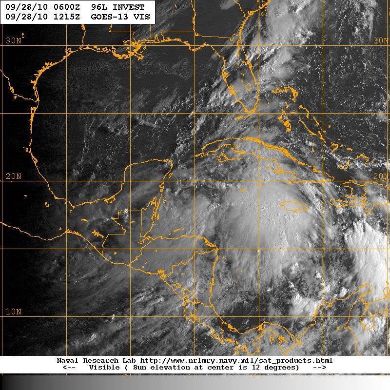
Yes, I think the LLC is developing in that area.
0 likes   

jhpigott
Category 2
Category 2
Posts: 570
Joined: Wed Jan 02, 2008 8:09 pm
Location: North Palm Beach, Florida

Re: ATL : INVEST 96L - Discussion

#380 Postby jhpigott » Tue Sep 28, 2010 8:25 am

Time and time again, models lift systems out of the Caribbean too soon. Maybe another case of that here? Looks like the majority of the convection this morning wants to stay south.
0 likes   


Return to “2010”

Who is online

Users browsing this forum: No registered users and 1 guest