Disturbance in the western Caribbean (Is invest 98L)
Moderator: S2k Moderators
Forum rules

The posts in this forum are NOT official forecasts and should not be used as such. They are just the opinion of the poster and may or may not be backed by sound meteorological data. They are NOT endorsed by any professional institution or STORM2K. For official information, please refer to products from the National Hurricane Center and National Weather Service.


-
gatorcane

- S2K Supporter

- Posts: 23708
- Age: 48
- Joined: Sun Mar 13, 2005 3:54 pm
- Location: Boca Raton, FL
Re:
Vortex wrote:as well defined as the circulation is becoming and with 6-7 days over water with favorable environmental conditions while S of cuba(minus any land interaction with honduras) this has significant potential...
Definitely has potential. I think the euro may have a better handle in the movement as the gfs is trying to eject this out of the Caribbean much too quickly, especially if you look at the 12z. As for the long-range shear forecasts, well we know how accurate they can be! Lol. Remember it is a la Nina year and it's still early October.
I think many have packed their bags due to a cooler and drier airmass that has set in over the eastern conus. Things could be much different 10 days to 14 days from now. If I were in florida (especially southern Florida) I would not be packing my bags just yet.
Last edited by gatorcane on Thu Oct 07, 2010 9:52 pm, edited 3 times in total.
0 likes
Re: Disturbance in the western Caribbean - Code Yellow
Major Hurricane Paloma approaching cuba in November...
Radar:
http://en.wikipedia.org/wiki/File:Palom ... 8_cmw2.gif
Radar:
http://en.wikipedia.org/wiki/File:Palom ... 8_cmw2.gif
0 likes
Not implying this will be a mitch of any sorts but mitch formed over the exact same area where we find a well defined circulation this evening...
http://en.wikipedia.org/wiki/Hurricane_Mitch
Hurricane mitch first advisory almost spot on as to where we have a
circulation this evening.
Hurricane Mitch
ADV DATE/TIME LAT LON WIND PRES STATUS
___ _________ ___ ___ ____ ____ ______
1 10/22/03Z 12.8N 77.9W 35MPH 1001 T.D. 13
http://en.wikipedia.org/wiki/Hurricane_Mitch
Hurricane mitch first advisory almost spot on as to where we have a
circulation this evening.
Hurricane Mitch
ADV DATE/TIME LAT LON WIND PRES STATUS
___ _________ ___ ___ ____ ____ ______
1 10/22/03Z 12.8N 77.9W 35MPH 1001 T.D. 13
0 likes
-
MGC

- S2K Supporter
- Posts: 5940
- Joined: Sun Mar 23, 2003 9:05 pm
- Location: Pass Christian MS, or what is left.
Re: Disturbance in the western Caribbean - Code Yellow
Quite of bit of spin just north of Panama....chances should increase at 2am. Would not be surprised if this developes in a couple of days......MGC
0 likes

Re: Disturbance in the western Caribbean - Code Yellow
Is it down by Panama or up by the west Caribbean convection?

0 likes
Re: Disturbance in the western Caribbean - Code Yellow
The 0Z gfs put me to sleep due to it being so boring. Zzzzzz. Good night, folks.
0 likes
Personal Forecast Disclaimer:
The posts in this forum are NOT official forecasts and should not be used as such. They are just the opinion of the poster and may or may not be backed by sound meteorological data. They are NOT endorsed by any professional institution or storm2k.org. For official information, please refer to the NHC and NWS products.
The posts in this forum are NOT official forecasts and should not be used as such. They are just the opinion of the poster and may or may not be backed by sound meteorological data. They are NOT endorsed by any professional institution or storm2k.org. For official information, please refer to the NHC and NWS products.
-
Florida1118
Re: Disturbance in the western Caribbean - Code Yellow
A BROAD TROUGH OF LOW PRESSURE CONTINUES TO PRODUCE AN AREA OF
SHOWERS AND THUNDERSTORMS OVER PORTIONS OF THE WESTERN CARIBBEAN
SEA. SOME SLOW DEVELOPMENT IS POSSIBLE AS THE SYSTEM REMAINS
NEARLY STATIONARY OVER THE NEXT FEW DAYS. THERE IS A LOW CHANCE...
20 PERCENT...OF TROPICAL CYCLONE FORMATION DURING THE NEXT 48
HOURS.
http://www.nhc.noaa.gov/gtwo_atl.shtml
0 likes
-
dwsqos2
Re: Disturbance in the western Caribbean - Code Yellow
Yeah, the 0Z Euro and 0Z Canadian are fairly good cures for insomnia as well.
0 likes

Re: Disturbance in the western Caribbean - Code Yellow
Looking at MIMIC-TPW, its seems Otto is advecting some of the moisture out of the SW Carib.
http://cimss.ssec.wisc.edu/tropic/real- ... /main.html
This could be limiting LL convergence from developing for maybe the next 24 hours or so until Otto moves farther away and weakens.
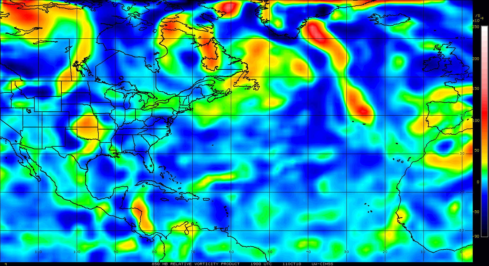
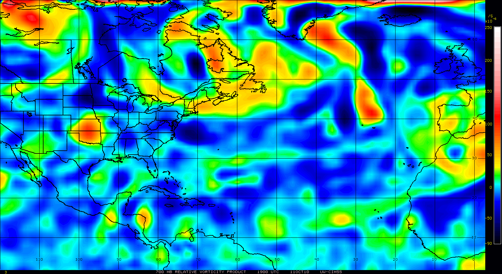
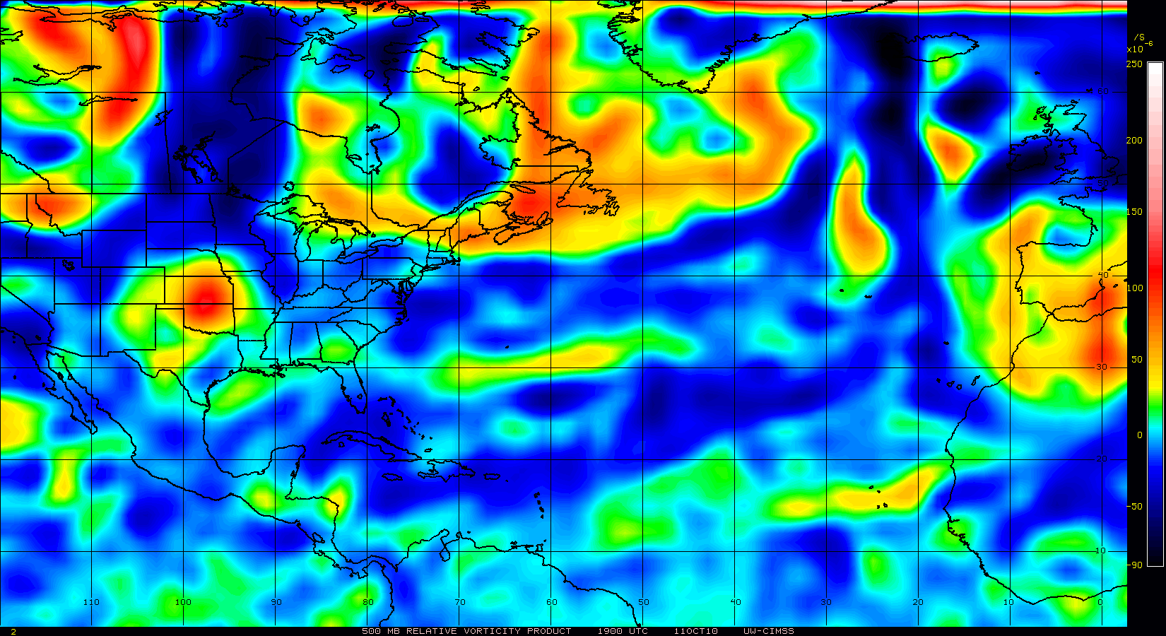
There now seems to be two PV anomolies, one at 850mb and another at 500mb.
The 500mb PV could be providing resistance to parcel ascent and maybe that is why convection has throttled back some.
I think once Otto clears out the 850mb vorticity should restrengthen and convection refire then.
Overall, shear is favorable east of 85W.

http://cimss.ssec.wisc.edu/tropic/real- ... /main.html
This could be limiting LL convergence from developing for maybe the next 24 hours or so until Otto moves farther away and weakens.
There now seems to be two PV anomolies, one at 850mb and another at 500mb.
The 500mb PV could be providing resistance to parcel ascent and maybe that is why convection has throttled back some.
I think once Otto clears out the 850mb vorticity should restrengthen and convection refire then.
Overall, shear is favorable east of 85W.
0 likes
-
cycloneye

- Admin

- Posts: 149585
- Age: 69
- Joined: Thu Oct 10, 2002 10:54 am
- Location: San Juan, Puerto Rico
Re: Disturbance in the western Caribbean - Code Yellow
TROPICAL WEATHER OUTLOOK
NWS TPC/NATIONAL HURRICANE CENTER MIAMI FL
800 AM EDT FRI OCT 8 2010
FOR THE NORTH ATLANTIC...CARIBBEAN SEA AND THE GULF OF MEXICO...
THE NATIONAL HURRICANE CENTER IS ISSUING ADVISORIES ON TROPICAL
STORM OTTO...LOCATED ABOUT 520 MILES SOUTH OF BERMUDA.
CLOUDINESS AND A FEW SHOWERS IN THE SOUTHWESTERN CARIBBEAN SEA ARE
ASSOCIATED WITH A BROAD TROUGH OF LOW PRESSURE. ENVIRONMENTAL
CONDITIONS APPEAR CONDUCIVE FOR SOME SLOW DEVELOPMENT OF THIS
SYSTEM AS IT REMAINS NEARLY STATIONARY DURING THE NEXT FEW DAYS.
THERE IS A LOW CHANCE...20 PERCENT...OF TROPICAL CYCLONE FORMATION
DURING THE NEXT 48 HOURS.
ELSEWHERE...TROPICAL CYCLONE FORMATION IS NOT EXPECTED DURING THE
NEXT 48 HOURS.
$$
FORECASTER KIMBERLAIN
0 likes
Visit the Caribbean-Central America Weather Thread where you can find at first post web cams,radars
and observations from Caribbean basin members Click Here
and observations from Caribbean basin members Click Here
Re: Disturbance in the western Caribbean - Code Yellow
6z Nam strong with hurricane over NW carribean
http://www.nco.ncep.noaa.gov/pmb/nwprod ... p_084l.gif
http://www.nco.ncep.noaa.gov/pmb/nwprod ... p_084l.gif
0 likes
-
SouthFloridawx

- S2K Supporter
- Posts: 8346
- Age: 47
- Joined: Tue Jul 26, 2005 1:16 am
- Location: Sarasota, FL
- Contact:
Re: Disturbance in the western Caribbean - Code Yellow
Here is a query of all storms in October within 100NM of 15.00N and 80.00W.

0 likes
-
SouthFloridawx
- S2K Supporter
- Posts: 8346
- Age: 47
- Joined: Tue Jul 26, 2005 1:16 am
- Location: Sarasota, FL
- Contact:
Re: Disturbance in the western Caribbean - Code Yellow
NAM shows Trough pulling out and cut-off low forming and heading into the Mid-Western States.
http://mag.ncep.noaa.gov/NCOMAGWEB/appcontroller?prevpage=Param&MainPage=index&image=&page=Param&cycle=10%2F08%2F2010+06UTC&rname=UPPER+AIR+PARMS&pname=500_vort_ht&model=NAM&area=NAMER&cat=MODEL+GUIDANCE&areaDesc=North+America+-+US%2C+Canada%2C+and+northern+Mexico&fcast=Loop+All
http://mag.ncep.noaa.gov/NCOMAGWEB/appcontroller?prevpage=Param&MainPage=index&image=&page=Param&cycle=10%2F08%2F2010+06UTC&rname=UPPER+AIR+PARMS&pname=500_vort_ht&model=NAM&area=NAMER&cat=MODEL+GUIDANCE&areaDesc=North+America+-+US%2C+Canada%2C+and+northern+Mexico&fcast=Loop+All
0 likes
Who is online
Users browsing this forum: No registered users and 207 guests