ATL: Remnants of PAULA - Discussion
Moderator: S2k Moderators
- SouthDadeFish
- Professional-Met

- Posts: 2836
- Joined: Thu Sep 23, 2010 2:54 pm
- Location: Miami, FL
- Contact:
- cycloneye
- Admin

- Posts: 149583
- Age: 69
- Joined: Thu Oct 10, 2002 10:54 am
- Location: San Juan, Puerto Rico
Re: ATL : INVEST 98L - Discussion - Code Orange 30%
18z Best Track
AL, 98, 2010100918, , BEST, 0, 129N, 801W, 25, 1009, LO
ftp://ftp.tpc.ncep.noaa.gov/atcf/tcweb/ ... 010.invest
Is moving west at 265 degrees. That means is going towards Nicaragua.
AL, 98, 2010100918, , BEST, 0, 129N, 801W, 25, 1009, LO
ftp://ftp.tpc.ncep.noaa.gov/atcf/tcweb/ ... 010.invest
Is moving west at 265 degrees. That means is going towards Nicaragua.
0 likes
Visit the Caribbean-Central America Weather Thread where you can find at first post web cams,radars
and observations from Caribbean basin members Click Here
and observations from Caribbean basin members Click Here
- SFLcane
- S2K Supporter

- Posts: 10281
- Age: 48
- Joined: Sat Jun 05, 2010 1:44 pm
- Location: Lake Worth Florida
Re: ATL : INVEST 98L - Discussion - Code Orange 30%
Just dont see how this would threaten florida as a signficant cyclone based on that shear zone across the NW caribbean sea. Conditions aloft look great though south of cuba.
0 likes
-
Aric Dunn
- Category 5

- Posts: 21238
- Age: 43
- Joined: Sun Sep 19, 2004 9:58 pm
- Location: Ready for the Chase.
- Contact:
What I dont get ... is why its not at around 80% because there is a closed circulation plenty of convection and with winds around 25 to 30kts
0 likes
Note: If I make a post that is brief. Please refer back to previous posts for the analysis or reasoning. I do not re-write/qoute what my initial post said each time.
If there is nothing before... then just ask
Space & Atmospheric Physicist, Embry-Riddle Aeronautical University,
I believe the sky is falling...
If there is nothing before... then just ask
Space & Atmospheric Physicist, Embry-Riddle Aeronautical University,
I believe the sky is falling...
-
Aric Dunn
- Category 5

- Posts: 21238
- Age: 43
- Joined: Sun Sep 19, 2004 9:58 pm
- Location: Ready for the Chase.
- Contact:
Re: ATL : INVEST 98L - Discussion - Code Orange 30%
Pretty straight forward... I have seen worse looking Tropical depressions.. Looks pretty good to me..


0 likes
Note: If I make a post that is brief. Please refer back to previous posts for the analysis or reasoning. I do not re-write/qoute what my initial post said each time.
If there is nothing before... then just ask
Space & Atmospheric Physicist, Embry-Riddle Aeronautical University,
I believe the sky is falling...
If there is nothing before... then just ask
Space & Atmospheric Physicist, Embry-Riddle Aeronautical University,
I believe the sky is falling...
- gatorcane
- S2K Supporter

- Posts: 23708
- Age: 48
- Joined: Sun Mar 13, 2005 3:54 pm
- Location: Boca Raton, FL
Re: ATL : INVEST 98L - Discussion - Code Orange 30%
SFLcane wrote:Just dont see how this would threaten florida as a signficant cyclone based on that shear zone across the NW caribbean sea. Conditions aloft look great though south of cuba.
So you are trusting the shear forecasts in the long-range? I certainly do not. If it were November 9th, then maybe I would trust them more. It's only October 9th. Prime-time for hurricanes in the NW Caribbean and prime-time season climatologically speaking for South FL, Cuba, and Bahamas strikes from the south.
Last edited by gatorcane on Sat Oct 09, 2010 2:07 pm, edited 1 time in total.
0 likes
30% Are you kidding me?
Sat pic 20 minutes ago.
http://rammb.cira.colostate.edu/ramsdis ... _floater_2
Sat pic 20 minutes ago.
http://rammb.cira.colostate.edu/ramsdis ... _floater_2
0 likes
- gatorcane
- S2K Supporter

- Posts: 23708
- Age: 48
- Joined: Sun Mar 13, 2005 3:54 pm
- Location: Boca Raton, FL
Re:
Vortex wrote:30% Are you kidding me?
Sat pic 20 minutes ago.
http://rammb.cira.colostate.edu/ramsdis ... _floater_2
Looks like a depression to me. Look at all of the moisture building to the east that is going to wrap into this. Lots of dry air to the North and West but so long as the circulation doesn't go inland, the NAM may just get this right with a forecast for a MAJOR hurricane Paula in the NW Caribbean in a few days.
Interests in Honduras, Cuba, and South Florida should closely monitor this situation.
0 likes
-
Aric Dunn
- Category 5

- Posts: 21238
- Age: 43
- Joined: Sun Sep 19, 2004 9:58 pm
- Location: Ready for the Chase.
- Contact:
There really is not reason this could not be a depression..
0 likes
Note: If I make a post that is brief. Please refer back to previous posts for the analysis or reasoning. I do not re-write/qoute what my initial post said each time.
If there is nothing before... then just ask
Space & Atmospheric Physicist, Embry-Riddle Aeronautical University,
I believe the sky is falling...
If there is nothing before... then just ask
Space & Atmospheric Physicist, Embry-Riddle Aeronautical University,
I believe the sky is falling...
- Blown Away
- S2K Supporter

- Posts: 10253
- Joined: Wed May 26, 2004 6:17 am
Re: Re:
gatorcane wrote:Vortex wrote:30% Are you kidding me?
Sat pic 20 minutes ago.
http://rammb.cira.colostate.edu/ramsdis ... _floater_2
Looks like a depression to me. Look at all of the moisture building to the east that is going to wrap into this. Lots of dry air to the North and West but so long as the circulation doesn't go inland, the NAM may just get this right with a forecast for a MAJOR hurricane Paula in the NW Caribbean in a few days.
Interests in Honduras, Cuba, and South Florida should closely monitor this situation.
The models continue to have 98L hitting a wall near western Cuba and turning sharply ENE. Something to watch in SFL but for now we seem to be protected by that trough next week.
0 likes
Hurricane Eye Experience: David 79, Irene 99, Frances 04, Jeanne 04, Wilma 05… Hurricane Brush Experience: Andrew 92, Erin 95, Floyd 99, Matthew 16, Irma 17, Ian 22, Nicole 22…
- gatorcane
- S2K Supporter

- Posts: 23708
- Age: 48
- Joined: Sun Mar 13, 2005 3:54 pm
- Location: Boca Raton, FL
Re: Re:
Blown Away wrote:gatorcane wrote:Vortex wrote:30% Are you kidding me?
Sat pic 20 minutes ago.
http://rammb.cira.colostate.edu/ramsdis ... _floater_2
Looks like a depression to me. Look at all of the moisture building to the east that is going to wrap into this. Lots of dry air to the North and West but so long as the circulation doesn't go inland, the NAM may just get this right with a forecast for a MAJOR hurricane Paula in the NW Caribbean in a few days.
Interests in Honduras, Cuba, and South Florida should closely monitor this situation.
The models continue to have 98L hitting a wall near western Cuba and turning sharply ENE. Something to watch in SFL but for now we seem to be protected by that trough next week.
I see that but this is all in the long-range still and we by no means have model consensus on this. Any time you have a system down there this time of year, we must watch it. Won't take much for it to take a NE vector instead of ENE.
0 likes
-
cyclonic chronic
looks like a depression to me. i think they're (NHC) waiting for persistance because convection has been up and down the last few days. is recon scheduled anytime soon, like tommrow? lol. the biggest threat, if it becomes a depr., looks like cuba. tho maybe it'll stay down in the carib. for a while, then s. fl needs to watch. local mets saying the humidity and at least a chance of rain coming back by late week. if that is true then the air wont be as dry as it is now here in s.w. fl. as for the shear forecasts, thats a crap-shoot. at least it looks like we have something purely tropical to track.
0 likes
- cycloneye
- Admin

- Posts: 149583
- Age: 69
- Joined: Thu Oct 10, 2002 10:54 am
- Location: San Juan, Puerto Rico
Re: ATL : INVEST 98L - Discussion
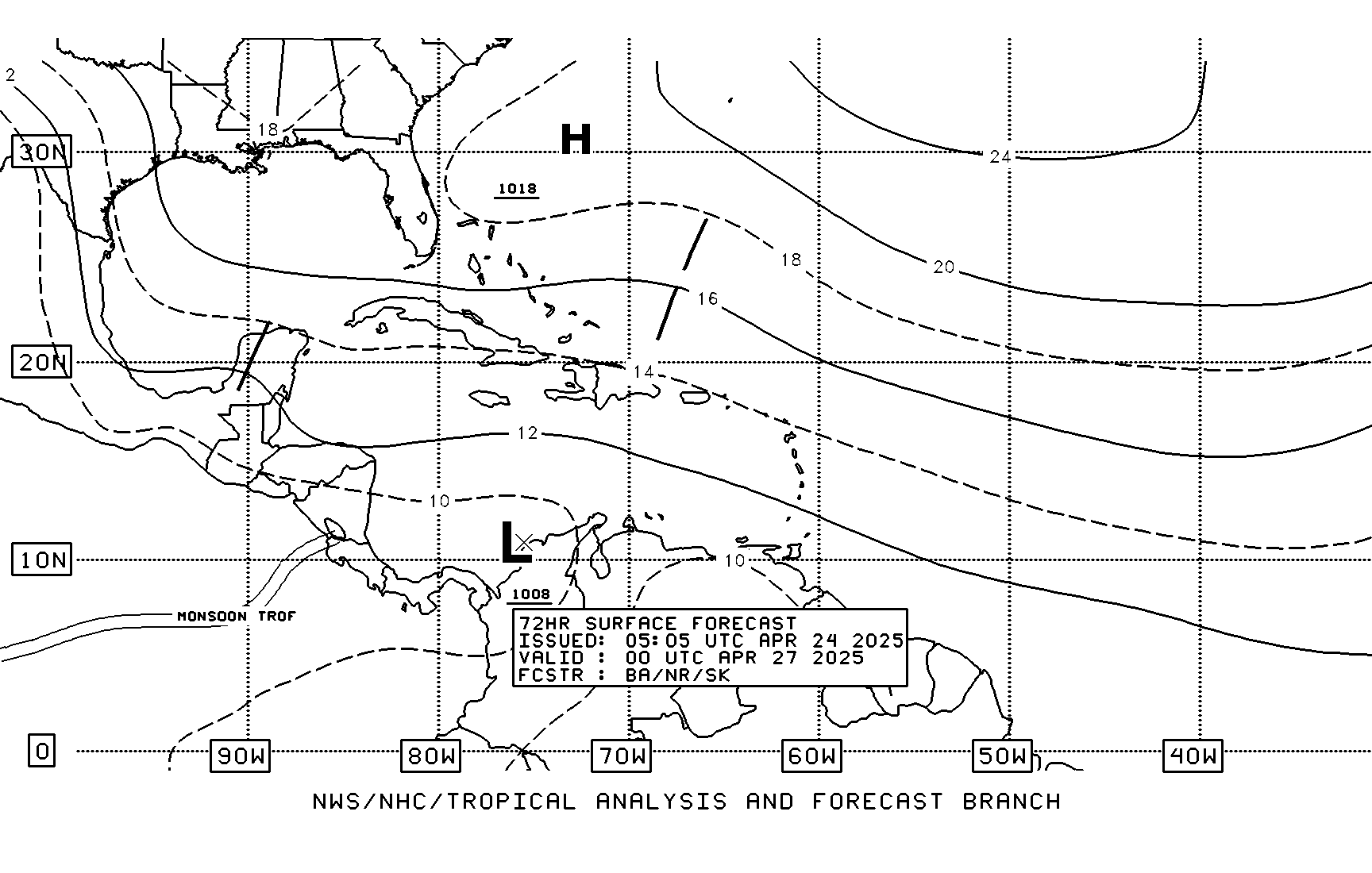
TAFB 72 hour forecast.


0 likes
Visit the Caribbean-Central America Weather Thread where you can find at first post web cams,radars
and observations from Caribbean basin members Click Here
and observations from Caribbean basin members Click Here
Re: Re:
Blown Away wrote:The models continue to have 98L hitting a wall near western Cuba and turning sharply ENE. Something to watch in SFL but for now we seem to be protected by that trough next week.
Maybe that will occur. Then again, maybe the models will verify incorrectly. Consider climo.
If the TC is able to move up to near W. Cuba, then mid to late OCT history says that the U.S. (mainly S FL) has almost always been later threatened and has most often actually been hit. For TC's of mid to late OCT since 1851 that were moving anywhere from a N to E heading over the W 1/3 of Cuba, consider this:
U.S. Hits: 1865, 1870 (2), 1876, 1878, 1891, 1906, 1909, 1922, 1924, 1926, 1944, 1947, 1959, 1964, 1968, 1987, 1999
U.S. Misses: 1898 (2 missed by only 50 miles), 1913, 1991 (missed by only 30 miles), 1996
So, there have been 18 hits, or about one every 9 years, and only 5 misses with three of the misses being very close. So, only 2 of the 23 were far from a hit.
0 likes
Personal Forecast Disclaimer:
The posts in this forum are NOT official forecasts and should not be used as such. They are just the opinion of the poster and may or may not be backed by sound meteorological data. They are NOT endorsed by any professional institution or storm2k.org. For official information, please refer to the NHC and NWS products.
The posts in this forum are NOT official forecasts and should not be used as such. They are just the opinion of the poster and may or may not be backed by sound meteorological data. They are NOT endorsed by any professional institution or storm2k.org. For official information, please refer to the NHC and NWS products.
Re: ATL : INVEST 98L - Discussion
Maybe a special TWO will be issued today unless a disoganization trend begins.
0 likes
-
Weatherfreak000
Who is online
Users browsing this forum: No registered users and 54 guests


