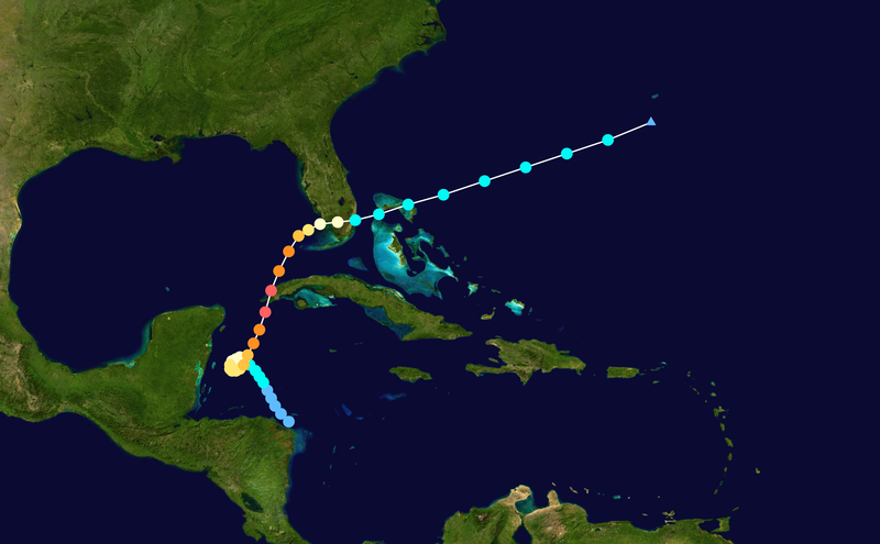
ATL: Remnants of PAULA - Discussion

Moderator: S2k Moderators

Message
Author
User avatar
Evil Jeremy
S2K Supporter
S2K Supporter
Posts: 5463
Age: 32
Joined: Mon Apr 10, 2006 2:10 pm
Location: Los Angeles, CA

Re: ATL: PAULA - Hurricane - Discussion

#1281 Postby Evil Jeremy » Wed Oct 13, 2010 10:50 am

So, at what point is the "what if" counter-productive??

You also make a good point. I believe this is what the forum disclaimer is for. Perhaps it should be used more.

Anyways, deep convection firing on the south side:
http://www.ssd.noaa.gov/goes/flt/t2/flash-wv.html
0 likes   
Frances 04 / Jeanne 04 / Katrina 05 / Wilma 05 / Fay 08 / Debby 12 / Andrea 13 / Colin 16 / Hermine 16 / Matthew 16 / Irma 17

xironman
S2K Supporter
S2K Supporter
Posts: 2522
Joined: Sun Jun 10, 2007 4:53 pm
Location: NoVA

Re: ATL: PAULA - Hurricane - Discussion

#1282 Postby xironman » Wed Oct 13, 2010 10:53 am

It helps she is moving, even slowly, in the direction of the UL winds.
0 likes   

User avatar
Evil Jeremy
S2K Supporter
S2K Supporter
Posts: 5463
Age: 32
Joined: Mon Apr 10, 2006 2:10 pm
Location: Los Angeles, CA

Re: ATL: PAULA - Hurricane - Discussion

#1283 Postby Evil Jeremy » Wed Oct 13, 2010 10:56 am

xironman wrote:It helps she is moving, even slowly, in the direction of the UL winds.


It helps advance or slow her weakening?
0 likes   
Frances 04 / Jeanne 04 / Katrina 05 / Wilma 05 / Fay 08 / Debby 12 / Andrea 13 / Colin 16 / Hermine 16 / Matthew 16 / Irma 17

User avatar
wxman57
Moderator-Pro Met
Moderator-Pro Met
Posts: 22978
Age: 67
Joined: Sat Jun 21, 2003 8:06 pm
Location: Houston, TX (southwest)

Re:

#1284 Postby wxman57 » Wed Oct 13, 2010 11:02 am

JPmia wrote:http://my.sfwmd.gov/sfwmd/common/images/weather/plots/storm_18.gif

I think likely track will be somewhere in between the NHC's line and the GFDL model track.

*My personal opinion and not official*


I agree with that. Paula may just clip NW Cuba and stay north of the island. But wind shear should weaken it to a TS before it passes south of the Keys and a depression prior to the Bahamas.
0 likes   

xironman
S2K Supporter
S2K Supporter
Posts: 2522
Joined: Sun Jun 10, 2007 4:53 pm
Location: NoVA

Re: ATL: PAULA - Hurricane - Discussion

#1285 Postby xironman » Wed Oct 13, 2010 11:04 am

I would think slow the weakening, since the relative shear would not be as strong.
0 likes   

User avatar
x-y-no
Category 5
Category 5
Posts: 8359
Age: 65
Joined: Wed Aug 11, 2004 12:14 pm
Location: Fort Lauderdale, FL

Re: Re:

#1286 Postby x-y-no » Wed Oct 13, 2010 11:07 am

wxman57 wrote:
JPmia wrote:http://my.sfwmd.gov/sfwmd/common/images/weather/plots/storm_18.gif

I think likely track will be somewhere in between the NHC's line and the GFDL model track.

*My personal opinion and not official*


I agree with that. Paula may just clip NW Cuba and stay north of the island. But wind shear should weaken it to a TS before it passes south of the Keys and a depression prior to the Bahamas.


That seems right to me too. I've been thinking for the last two days that the GFDL has the right basic idea but a tad too far north given the strength of the westerlies.
0 likes   

User avatar
HURAKAN
Professional-Met
Professional-Met
Posts: 46086
Age: 38
Joined: Thu May 20, 2004 4:34 pm
Location: Key West, FL
Contact:

#1287 Postby HURAKAN » Wed Oct 13, 2010 11:23 am

Image

Latest
0 likes   

User avatar
Ntxw
Storm2k Moderator
Storm2k Moderator
Posts: 22784
Joined: Wed Oct 21, 2009 6:34 pm
Location: DFW, Texas

#1288 Postby Ntxw » Wed Oct 13, 2010 11:27 am

Looks pretty evident that any part of her going north of Cuba is being/ will be pulled and ripped away from her. The turn seems to have taken place and building is to the south side where it's more favorable. Looks like she spared the Yucatan peninsula with minimal impact.
Last edited by Ntxw on Wed Oct 13, 2010 11:28 am, edited 1 time in total.
0 likes   
The above post and any post by Ntxw is NOT an official forecast and should not be used as such. It is just the opinion of the poster and may or may not be backed by sound meteorological data. It is NOT endorsed by any professional institution including Storm2k. For official information, please refer to NWS products.

  Help support Storm2K!
Help Support Storm2K

Dean4Storms
S2K Supporter
S2K Supporter
Posts: 6358
Age: 62
Joined: Sun Aug 31, 2003 1:01 pm
Location: Miramar Bch. FL

#1289 Postby Dean4Storms » Wed Oct 13, 2010 11:28 am

Becoming elongated, a sure sign that Paula could become decouple from the UL circulation before much longer. Once that occurs it will weaken rapidly IMO.

http://www.ssd.noaa.gov/goes/flt/t2/flash-wv.html


This is my personal opinion and not anything official. You should get all your official information from official authorities.
0 likes   

User avatar
gatorcane
S2K Supporter
S2K Supporter
Posts: 23691
Age: 47
Joined: Sun Mar 13, 2005 3:54 pm
Location: Boca Raton, FL

#1290 Postby gatorcane » Wed Oct 13, 2010 11:31 am

still moving north but has slowed down some.
0 likes   

User avatar
Weatherboy1
Category 5
Category 5
Posts: 1189
Age: 49
Joined: Mon Jul 05, 2004 1:50 pm
Location: Jupiter/Sarasota, FL

#1291 Postby Weatherboy1 » Wed Oct 13, 2010 11:37 am

I have no doubt that Paula will be steered/impacted by the shear and westerlies. But where is the southern extent of the strongest westerlies? Aren't they a bit further north ... and if Paula begins to accelerate to the ENE, won't storm-relative shear be less severe? This is NOT going to be a major, damaging storm in my opinion. But couldn't she maintain more of her strength if she is moving with the shear (a la Otto) not against it (a la some of our earlier season storms)?
0 likes   

User avatar
HURAKAN
Professional-Met
Professional-Met
Posts: 46086
Age: 38
Joined: Thu May 20, 2004 4:34 pm
Location: Key West, FL
Contact:

#1292 Postby HURAKAN » Wed Oct 13, 2010 11:47 am

RECON reporting winds at just 10 knots at 400 mb and still quite far from Paula

Image
Last edited by HURAKAN on Wed Oct 13, 2010 11:49 am, edited 1 time in total.
0 likes   

tolakram
Admin
Admin
Posts: 20009
Age: 62
Joined: Sun Aug 27, 2006 8:23 pm
Location: Florence, KY (name is Mark)

Re:

#1293 Postby tolakram » Wed Oct 13, 2010 11:49 am

HURAKAN wrote:RECON reporting winds at just 10 knots at 400 mb and still quite far from Paula


I think that would be mid level shear and 10 kts sounds about right according to the mid level shear analysis.
0 likes   
M a r k
- - - - -
Join us in chat: Storm2K Chatroom Invite. Android and IOS apps also available.

The posts in this forum are NOT official forecasts and should not be used as such. Posts are NOT endorsed by any professional institution or STORM2K.org. For official information and forecasts, please refer to NHC and NWS products.

User avatar
Evil Jeremy
S2K Supporter
S2K Supporter
Posts: 5463
Age: 32
Joined: Mon Apr 10, 2006 2:10 pm
Location: Los Angeles, CA

Re:

#1294 Postby Evil Jeremy » Wed Oct 13, 2010 11:50 am

HURAKAN wrote:RECON reporting winds at just 10 knots at 400 mb and still quite far from Paula

http://i56.tinypic.com/20sgak3.jpg


What does this mean shear wise?
0 likes   
Frances 04 / Jeanne 04 / Katrina 05 / Wilma 05 / Fay 08 / Debby 12 / Andrea 13 / Colin 16 / Hermine 16 / Matthew 16 / Irma 17

User avatar
KWT
Category 5
Category 5
Posts: 31415
Joined: Tue Aug 17, 2004 11:02 am
Location: UK!!!

#1295 Postby KWT » Wed Oct 13, 2010 12:15 pm

Quite obvious tilting occuring with Paula, for now its leading to much in the way of problems but as the core itself gets into that region I'm pretty sure it will start to weaken quickly.
0 likes   
Personal Forecast Disclaimer:
The posts in this forum are NOT official forecast and should not be used as such. They are just the opinion of the poster and may or may not be backed by sound meteorological data. They are NOT endorsed by any professional institution or storm2k.org. For official information, please refer to the NHC and NWS products

User avatar
HURAKAN
Professional-Met
Professional-Met
Posts: 46086
Age: 38
Joined: Thu May 20, 2004 4:34 pm
Location: Key West, FL
Contact:

Re: Re:

#1296 Postby HURAKAN » Wed Oct 13, 2010 12:22 pm

Evil Jeremy wrote:
HURAKAN wrote:RECON reporting winds at just 10 knots at 400 mb and still quite far from Paula

http://i56.tinypic.com/20sgak3.jpg


What does this mean shear wise?


That the worse shear is still north of Paula
0 likes   

User avatar
gatorcane
S2K Supporter
S2K Supporter
Posts: 23691
Age: 47
Joined: Sun Mar 13, 2005 3:54 pm
Location: Boca Raton, FL

#1297 Postby gatorcane » Wed Oct 13, 2010 12:22 pm

Paula looks to be doing just fine. Shear not getting to her just yet.
0 likes   

User avatar
KWT
Category 5
Category 5
Posts: 31415
Joined: Tue Aug 17, 2004 11:02 am
Location: UK!!!

#1298 Postby KWT » Wed Oct 13, 2010 12:27 pm

Yeah the core still looks solid and recon will IMO find a system probably at a similar strength as before but I do think its obvious given the tilting that there is some shear to the north at least at some level.
0 likes   
Personal Forecast Disclaimer:
The posts in this forum are NOT official forecast and should not be used as such. They are just the opinion of the poster and may or may not be backed by sound meteorological data. They are NOT endorsed by any professional institution or storm2k.org. For official information, please refer to the NHC and NWS products

User avatar
AdamFirst
S2K Supporter
S2K Supporter
Posts: 2491
Age: 36
Joined: Thu Aug 14, 2008 10:54 am
Location: Port Saint Lucie, FL

#1299 Postby AdamFirst » Wed Oct 13, 2010 12:39 pm

Looks like the storm is growing size-wise.
0 likes   
Dolphins Marlins Canes Golden Panthers HEAT
Andrew 1992 - Irene 1999 - Frances 2004 - Jeanne 2004 - Wilma 2005 - Fay 2008 - Isaac 2012 - Matthew 2016 - Irma 2017 - Dorian 2019 - Ian 2022 - Nicole 2022 - Milton 2024

HurricaneRobert
Category 3
Category 3
Posts: 812
Joined: Fri May 18, 2007 9:31 pm

Re: ATL: PAULA - Hurricane - Discussion

#1300 Postby HurricaneRobert » Wed Oct 13, 2010 12:42 pm

Wow. Here's something that happened in the same place/time as Paula. It was probably a small hurricane too.

Image
0 likes   


Return to “2010”

Who is online

Users browsing this forum: No registered users and 4 guests