29 in oklahoma! yessss very nice to see cold weather this far south ...enjoy
it's currently 40 degrees in the high elevations of ncarolina for a high temp today....could be some flurries as upper low swing by.
http://www.wunderground.com/weatherstat ... =KNCBEECH3
Winter 2010-11 for the Southern Plains
Moderator: S2k Moderators
Forum rules
 The posts in this forum are NOT official forecast and should not be used as such. They are just the opinion of the poster and may or may not be backed by sound meteorological data. They are NOT endorsed by any professional institution or STORM2K.

The posts in this forum are NOT official forecast and should not be used as such. They are just the opinion of the poster and may or may not be backed by sound meteorological data. They are NOT endorsed by any professional institution or STORM2K.
-
Extremeweatherguy

- Category 5

- Posts: 11095
- Joined: Mon Oct 10, 2005 8:13 pm
- Location: Florida
Re: Winter 2010-11 for the Southern Plains
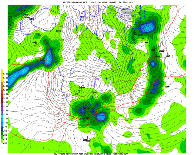
The first fantasy snowstorm of the year has made an appearance on today's long-range GFS:
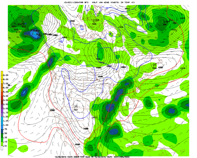
If by some miracle this were to actually play out, then it would go down as Oklahoma City's earliest snowfall ever (the current record is October 25th). I highly doubt that will happen.. lol
If by some miracle this were to actually play out, then it would go down as Oklahoma City's earliest snowfall ever (the current record is October 25th). I highly doubt that will happen.. lol
0 likes
-
srainhoutx

- S2K Supporter

- Posts: 6919
- Age: 68
- Joined: Sun Jan 14, 2007 11:34 am
- Location: Haywood County, NC
- Contact:
Re: Winter 2010-11 for the Southern Plains
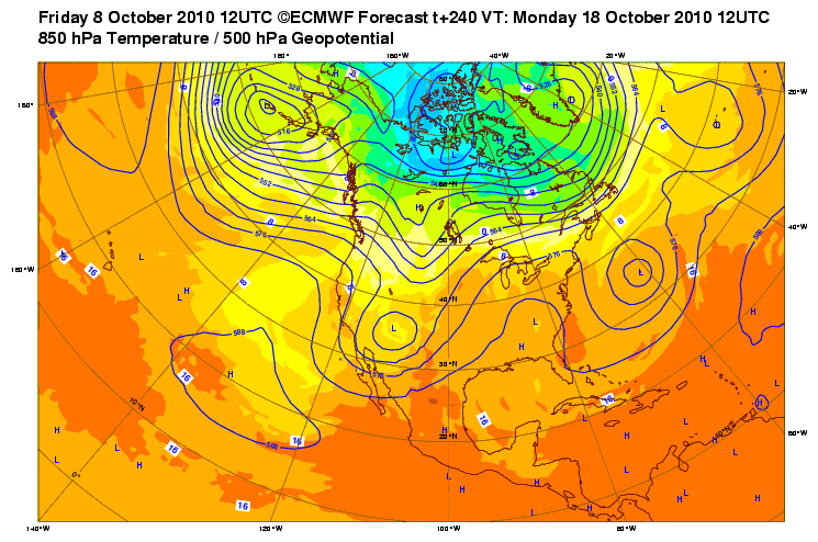
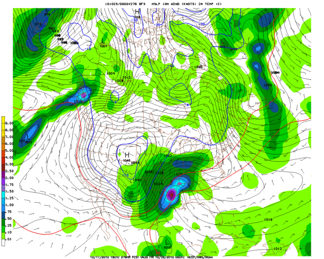
The 12Z Euro suggests a big Upper Low to the W at hour 240, so you never know. 
0 likes
Carla/Alicia/Jerry(In The Eye)/Michelle/Charley/Ivan/Dennis/Katrina/Rita/Wilma/Ike/Harvey
Member: National Weather Association
Wx Infinity Forums
http://wxinfinity.com/index.php
Facebook.com/WeatherInfinity
Twitter @WeatherInfinity
Member: National Weather Association
Wx Infinity Forums
http://wxinfinity.com/index.php
Facebook.com/WeatherInfinity
Twitter @WeatherInfinity
-
somethingfunny

- ChatStaff

- Posts: 3926
- Age: 37
- Joined: Thu May 31, 2007 10:30 pm
- Location: McKinney, Texas
Re: Winter 2010-11 for the Southern Plains

I'll mark my calendar. October 18!
0 likes
I am not a meteorologist, and any posts made by me are not official forecasts or to be interpreted as being intelligent. These posts are just my opinions and are probably silly opinions.

I don't buy that solution..yet  but models have been showing consistently a chilly air mass coming down. Could be the first snowstorm of the season for the high plains (Colorado to the Dakotas). Probably a cool, damp time for the southern plains if a cutoff low develops.
0 likes
The above post and any post by Ntxw is NOT an official forecast and should not be used as such. It is just the opinion of the poster and may or may not be backed by sound meteorological data. It is NOT endorsed by any professional institution including Storm2k. For official information, please refer to NWS products.
Help support Storm2K!
-
Portastorm

- Storm2k Moderator

- Posts: 9954
- Age: 63
- Joined: Fri Jul 11, 2003 9:16 am
- Location: Round Rock, TX
- Contact:
Re: Winter 2010-11 for the Southern Plains
It is worth noting that for several days now the GFS has been suggesting a turn to cooler weather during the last 10 days of October. And there are some very good weather minds who believe we'll see a western ridge/eastern trough setup due to relaxed Pacific flow and an active MJO wave.
0 likes
Re: Winter 2010-11 for the Southern Plains
not sure wether this has been talked about (esp NY NJ PA promet)
but it looks like the majority of the winter will be warmer than normal in the Northeast
with a cold period sometime late nov/ early-mid dec
this really S(*$*
but it looks like the majority of the winter will be warmer than normal in the Northeast
with a cold period sometime late nov/ early-mid dec
this really S(*$*
0 likes
-
Portastorm
- Storm2k Moderator
- Posts: 9954
- Age: 63
- Joined: Fri Jul 11, 2003 9:16 am
- Location: Round Rock, TX
- Contact:
Re: Winter 2010-11 for the Southern Plains
Dunno about the Northeast, but I'm really thinking the Southern Plains on a whole will be above normal temps and below normal precip. I do, however, think we will see several Arctic outbreaks which will provide a dramatic change in the weather for brief periods. The very cold Arctic air will be available and the strong Pacific jet will buckle at times. We see it every La Nina winter.
0 likes
-
NY NJ PA Weather
- Professional-Met

- Posts: 22
- Age: 46
- Joined: Fri Sep 10, 2010 9:39 am
- Location: Freehold, New Jersey
- Contact:
Re: Winter 2010-11 for the Southern Plains
I would be VERY careful with that warm idea for the Plains on through the Northern Mid Atlantic and Northeast. I've been quiet lately as I've been working on the winter forecast. My hint right now, take a look at stratospheric anomalies over Greenland and North America along with the 500 MB QBO levels combined with the Indian Ocean convection.
0 likes
Let the Water Vapor Satellite lead the way!
Re: Winter 2010-11 for the Southern Plains
NY NJ PA Weather wrote:I would be VERY careful with that warm idea for the Plains on through the Northern Mid Atlantic and Northeast. I've been quiet lately as I've been working on the winter forecast. My hint right now, take a look at stratospheric anomalies over Greenland and North America along with the 500 MB QBO levels combined with the Indian Ocean convection.
I have no doubt that there will be plenty of cold air readily available and the high plains will get plastered this winter. I think the southern plains will have surges of warmth battling with the cold more so than last year. However, I do find it odd that the models (though far out and unreliable) continues to swing cutoff lows through the southwest for late October which is something typical of an El Nino.
Also like today's system pushing down the plains through the midsouth, it too doesn't seem typical (Perhaps the SJT won't be as quiet as we thought cough cough hint take a look at what's going on west of the dateline/south-sw of Hawaii
Pacific seems cold, -pdo, different cycle than we've had data for, who knows!
0 likes
The above post and any post by Ntxw is NOT an official forecast and should not be used as such. It is just the opinion of the poster and may or may not be backed by sound meteorological data. It is NOT endorsed by any professional institution including Storm2k. For official information, please refer to NWS products.
Help support Storm2K!
Help support Storm2K!
-
NY NJ PA Weather
- Professional-Met
- Posts: 22
- Age: 46
- Joined: Fri Sep 10, 2010 9:39 am
- Location: Freehold, New Jersey
- Contact:
Re: Winter 2010-11 for the Southern Plains
The latest data coming out on LA NINA strongly suggest a very strong east based La Nina combined with a negative PDO pattern. This La Nina is not your early to mid 2000 or even 90's La Nina. Heck, it's not even your 70's La Nina. We are in a totally different ball game. The rise of the AMO is striking and the forcing around India is a telling sign. Finally, you are right to be concerned about the strong upper low over the Plains and Northeast, however this is more of an indication of the volatility and energy in the Polar jet stream than the Sub Tropical Jet Stream.
Almost done with the winter update. I'll put a post up and put out the basic ideas when I'm all done.
Almost done with the winter update. I'll put a post up and put out the basic ideas when I'm all done.
0 likes
Let the Water Vapor Satellite lead the way!
-
srainhoutx
- S2K Supporter
- Posts: 6919
- Age: 68
- Joined: Sun Jan 14, 2007 11:34 am
- Location: Haywood County, NC
- Contact:
Re: Winter 2010-11 for the Southern Plains
NY NJ PA Weather wrote:The latest data coming out on LA NINA strongly suggest a very strong east based La Nina combined with a negative PDO pattern. This La Nina is not your early to mid 2000 or even 90's La Nina. Heck, it's not even your 70's La Nina. We are in a totally different ball game. The rise of the AMO is striking and the forcing around India is a telling sign. Finally, you are right to be concerned about the strong upper low over the Plains and Northeast, however this is more of an indication of the volatility and energy in the Polar jet stream than the Sub Tropical Jet Stream.
Almost done with the winter update. I'll put a post up and put out the basic ideas when I'm all done.
We look forward to your update, NY NJ PA Weather. Good stuff folks.
0 likes
Carla/Alicia/Jerry(In The Eye)/Michelle/Charley/Ivan/Dennis/Katrina/Rita/Wilma/Ike/Harvey
Member: National Weather Association
Wx Infinity Forums
http://wxinfinity.com/index.php
Facebook.com/WeatherInfinity
Twitter @WeatherInfinity
Member: National Weather Association
Wx Infinity Forums
http://wxinfinity.com/index.php
Facebook.com/WeatherInfinity
Twitter @WeatherInfinity
Anyone want to take a guess when the first 'wintry' threat will be for any area of the southern plains? =p I'll say Nov 30th for Oklahoma Dec 10th for north Tx, Dec 15th for Central and Southeast Tx
0 likes
The above post and any post by Ntxw is NOT an official forecast and should not be used as such. It is just the opinion of the poster and may or may not be backed by sound meteorological data. It is NOT endorsed by any professional institution including Storm2k. For official information, please refer to NWS products.
Help support Storm2K!
Help support Storm2K!
-
Portastorm
- Storm2k Moderator
- Posts: 9954
- Age: 63
- Joined: Fri Jul 11, 2003 9:16 am
- Location: Round Rock, TX
- Contact:
Re:
Ntxw wrote:Anyone want to take a guess when the first 'wintry' threat will be for any area of the southern plains? =p I'll say Nov 30th for Oklahoma Dec 10th for north Tx, Dec 15th for Central and Southeast Tx
During La Nina winters when there is very cold air to our north ... we have seen the prevailing jet stream buckle enough in the latter half of November to create possible wintry weather threats for parts of Texas. So, it is not out of the question that someone here may get a nice surprise around Thanksgiving. For example, 1955-56 was a La Nina winter and parts of West Austin got 1-3 inches of snow in late November. It can happen.
With the strength of the Nina this year almost unparalleled as well as the volatility of the Polar jet as NY NJ PA Weather describes ... we could be in for a few nice surprises this winter. Overall though I don't see how it will be anything but above average temps and below average precip.
0 likes
-
vbhoutex

- Storm2k Executive

- Posts: 29145
- Age: 74
- Joined: Wed Oct 09, 2002 11:31 pm
- Location: Cypress, TX
- Contact:
Re:
Ntxw wrote:Anyone want to take a guess when the first 'wintry' threat will be for any area of the southern plains? =p I'll say Nov 30th for Oklahoma Dec 10th for north Tx, Dec 15th for Central and Southeast Tx
Nov 25th for OKC, Dec 5th for North TX, Dec 24th for Central TX and Dec 25th for SE TX(How's that for -removed-?
0 likes
Skywarn, C.E.R.T.
Please click below to donate to STORM2K to help with the expenses of keeping the site going:

Please click below to donate to STORM2K to help with the expenses of keeping the site going:
-
CaptinCrunch

- S2K Supporter
- Posts: 8776
- Age: 58
- Joined: Mon Nov 03, 2003 4:33 pm
- Location: Kennedale, TX (Tarrant Co.)
Re: Re:
Portastorm wrote:Ntxw wrote:Anyone want to take a guess when the first 'wintry' threat will be for any area of the southern plains? =p I'll say Nov 30th for Oklahoma Dec 10th for north Tx, Dec 15th for Central and Southeast Tx
During La Nina winters when there is very cold air to our north ... we have seen the prevailing jet stream buckle enough in the latter half of November to create possible wintry weather threats for parts of Texas. So, it is not out of the question that someone here may get a nice surprise around Thanksgiving. For example, 1955-56 was a La Nina winter and parts of West Austin got 1-3 inches of snow in late November. It can happen.
With the strength of the Nina this year almost unparalleled as well as the volatility of the Polar jet as NY NJ PA Weather describes ... we could be in for a few nice surprises this winter. Overall though I don't see how it will be anything but above average temps and below average precip.
This yrs La Nina looks different than past La Nina's for NTX. compairing last yrs El Nino for the months of Sept and Oct to this yrs La Nina for the same period.
El Nino Sept 2009 - Monthly avg was 76.1 (1.4 below avg) with 4.63 inches above avg rainfall
La Nina Sept 2010 - Monthly avg was 78.6 (1.9 above avg) with 6.67 inches above avg rainfall
El Nino Oct 2009 - Monthly avg was 62.7 (4.5 below avg) with 3.87 inches above avg rainfall
La Nina Oct 2010 - Monthly avg thru the 16th 68.3 (1.8 below avg) with 2.11 inches below avg rainfall
With half the month to go and rain chances back in te forcast we should close the gap on the rainfall totals, and with monthly temps looking to remain at or slightly above normal for highs and at or slighly below normal for lows October should end with a monthly avg at or below normal and precip slightly below normal. If La Nina continues to show a strong eastern base setup out winter here across NTX will be closer to normal than not.
0 likes
-
Portastorm
- Storm2k Moderator
- Posts: 9954
- Age: 63
- Joined: Fri Jul 11, 2003 9:16 am
- Location: Round Rock, TX
- Contact:
Re: Winter 2010-11 for the Southern Plains
That is true, Captin. An east-based Nina will keep temps at normal or slightly above normal for the winter for Texas ... with above average anamolies increasing the further south in the state you go.
The latest ENSO figures still show an east-based Nina with the strongest negative SST anamolies being in the east-central Pacific Ocean. Going to be very interesting to watch.
The latest ENSO figures still show an east-based Nina with the strongest negative SST anamolies being in the east-central Pacific Ocean. Going to be very interesting to watch.
0 likes
-
Extremeweatherguy
- Category 5
- Posts: 11095
- Joined: Mon Oct 10, 2005 8:13 pm
- Location: Florida
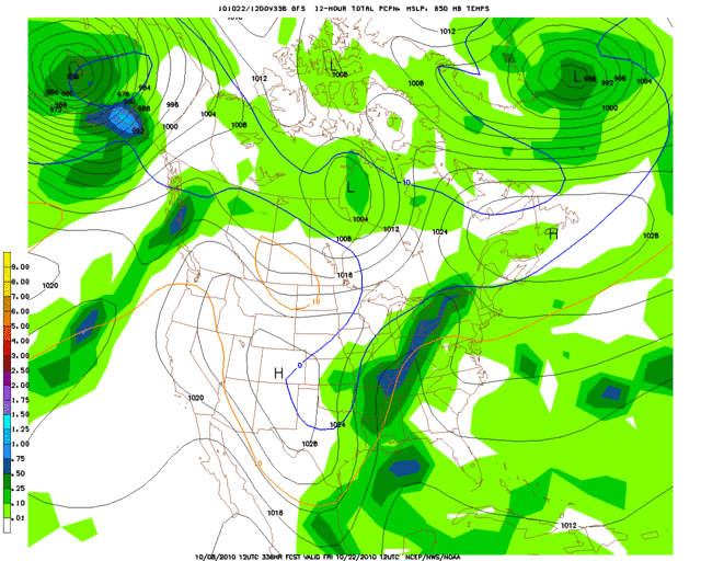
Another *probably* fantasy snowstorm on today's long range GFS just 2-3 days before halloween...
SURFACE
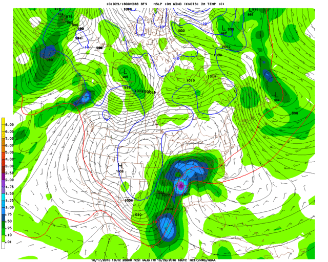
850MB
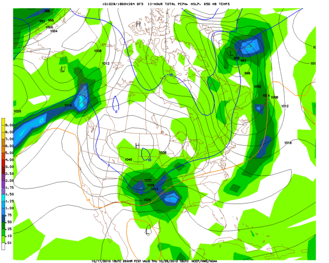

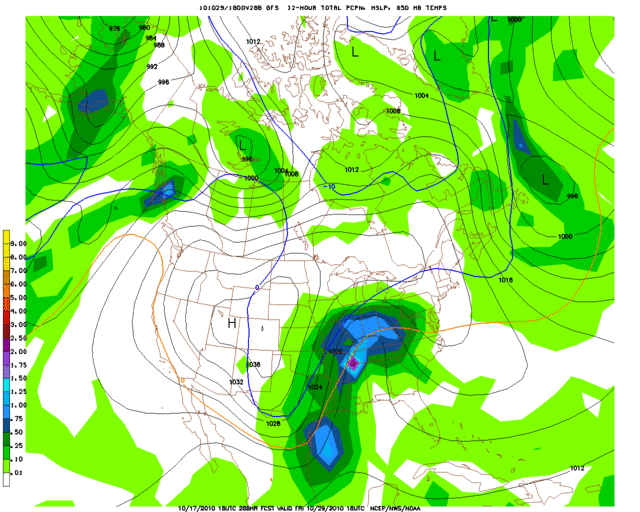
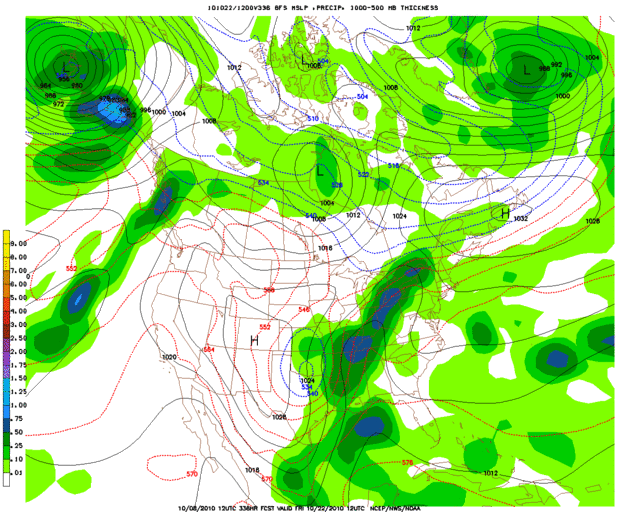
While this run is likely nothing but pure fiction, it is worth noting that it has actually snowed in OKC during the last part of the month before. It is definitely not a common occurrence though! since 1891 it has happened less than 10 times total. The most recent October snow occurred on Halloween day 1991 when a trace fell, and the greatest one day October accumulations are 0.5" and 0.8", both happening in 1913 on the 26th and 29th of the month. It would be pretty interesting to see a repeat scenario of such events, but until we are seeing GFS runs like this in the near term, its not worth getting excited about.
SURFACE
850MB
While this run is likely nothing but pure fiction, it is worth noting that it has actually snowed in OKC during the last part of the month before. It is definitely not a common occurrence though! since 1891 it has happened less than 10 times total. The most recent October snow occurred on Halloween day 1991 when a trace fell, and the greatest one day October accumulations are 0.5" and 0.8", both happening in 1913 on the 26th and 29th of the month. It would be pretty interesting to see a repeat scenario of such events, but until we are seeing GFS runs like this in the near term, its not worth getting excited about.
0 likes
^ If it were December I might consider it a remote possibility. Could use the pattern change for some rain, been somewhat dry lately.
0 likes
The above post and any post by Ntxw is NOT an official forecast and should not be used as such. It is just the opinion of the poster and may or may not be backed by sound meteorological data. It is NOT endorsed by any professional institution including Storm2k. For official information, please refer to NWS products.
Help support Storm2K!
Help support Storm2K!
Who is online
Users browsing this forum: Google Adsense [Bot] and 77 guests