I do not think so. Latest TWO has it moving north.boca wrote:It would head right into Central America everything is moving WNW.
Disturbed area north of Panama - (Is invest 99L)
Moderator: S2k Moderators
Forum rules

The posts in this forum are NOT official forecasts and should not be used as such. They are just the opinion of the poster and may or may not be backed by sound meteorological data. They are NOT endorsed by any professional institution or STORM2K. For official information, please refer to products from the National Hurricane Center and National Weather Service.
-
CourierPR

- Category 5

- Posts: 1336
- Age: 72
- Joined: Tue Aug 31, 2004 7:53 pm
- Location: Pompano Beach, Florida
Re: Disturbed area north of Panama
0 likes
-
cycloneye

- Admin

- Posts: 149508
- Age: 69
- Joined: Thu Oct 10, 2002 10:54 am
- Location: San Juan, Puerto Rico
Re: Disturbed area north of Panama - Code Yellow
TROPICAL WEATHER OUTLOOK
NWS TPC/NATIONAL HURRICANE CENTER MIAMI FL
800 AM EDT SAT OCT 16 2010
FOR THE NORTH ATLANTIC...CARIBBEAN SEA AND THE GULF OF MEXICO...
DISORGANIZED SHOWERS AND THUNDERSTORMS LOCATED OVER THE SOUTHWESTERN
CARIBBEAN SEA ARE ASSOCIATED WITH A WEAK TROUGH OF LOW PRESSURE.
SLOW DEVELOPMENT OF THIS SYSTEM IS POSSIBLE DURING THE NEXT COUPLE
OF DAYS AS IT DRIFTS NORTHWARD OR NORTHWESTWARD. THERE IS A LOW
CHANCE...10 PERCENT...OF THIS SYSTEM BECOMING A TROPICAL CYCLONE
DURING THE NEXT 48 HOURS.
ELSEWHERE...TROPICAL CYCLONE FORMATION IS NOT EXPECTED DURING THE
NEXT 48 HOURS.
$$
FORECASTER BRENNAN
0 likes
Visit the Caribbean-Central America Weather Thread where you can find at first post web cams,radars
and observations from Caribbean basin members Click Here
and observations from Caribbean basin members Click Here
Re: Disturbed area north of Panama - Code Yellow
Both the 0Z and 6Z GFS runs have Richard staying to the left and dieing over C.A./MX. Although only the third most frequent scenario, this is a very reasonable possibility per climo, which shows that a respectable 20% of W. Caribbean mid to late OCT storms (13 of 64) have done just that kind of thing. The 0Z Euro doesn't even have Richard.
0 likes
Personal Forecast Disclaimer:
The posts in this forum are NOT official forecasts and should not be used as such. They are just the opinion of the poster and may or may not be backed by sound meteorological data. They are NOT endorsed by any professional institution or storm2k.org. For official information, please refer to the NHC and NWS products.
The posts in this forum are NOT official forecasts and should not be used as such. They are just the opinion of the poster and may or may not be backed by sound meteorological data. They are NOT endorsed by any professional institution or storm2k.org. For official information, please refer to the NHC and NWS products.
-
wzrgirl1

- S2K Supporter

- Posts: 1360
- Joined: Sat Sep 04, 2004 6:44 am
- Location: Pembroke Pines, Florida
Re: Disturbed area north of Panama - Code Yellow
What is c.a.? I know it isn't California....
0 likes
-
Ad Novoxium
- Category 1

- Posts: 348
- Age: 35
- Joined: Sat May 03, 2008 2:12 am
-
wzrgirl1
- S2K Supporter
- Posts: 1360
- Joined: Sat Sep 04, 2004 6:44 am
- Location: Pembroke Pines, Florida
Re: Disturbed area north of Panama - Code Yellow
Yes I should have known that. Haven't had my coffee yet.....  Thanks!
0 likes
-
andrewsurvivor
- Tropical Low

- Posts: 43
- Age: 69
- Joined: Mon Aug 02, 2010 11:45 am
- Location: So.Florida
Re: Disturbed area north of Panama - Code Yellow
Yep, Central America. If that scenerio plays out flooding could be a serious issue.
0 likes
Cat 5
-
gatorcane

- S2K Supporter
- Posts: 23708
- Age: 48
- Joined: Sun Mar 13, 2005 3:54 pm
- Location: Boca Raton, FL
Re: Disturbed area north of Panama - Code Yellow
LarryWx wrote:Both the 0Z and 6Z GFS runs have Richard staying to the left and dieing over C.A./MX. Although only the third most frequent scenario, this is a very reasonable possibility per climo, which shows that a respectable 20% of W. Caribbean mid to late OCT storms (13 of 64) have done just that kind of thing. The 0Z Euro doesn't even have Richard.
Cmc also pushes it into central America. Should this happen, the US's luck continues as this is only a 20% chance based on climo and one would think troughs would be around this time of year to pull it northward.
Also, though the ecmwf doesn't pick up on this system, check out the 500mb heights a week from now. Looks like ridging builds in a big way over the nw caribbean. The flow across the conus becomes very zonal.
Looks like no threat to the conus at this time.
0 likes
-
wzrgirl1
- S2K Supporter
- Posts: 1360
- Joined: Sat Sep 04, 2004 6:44 am
- Location: Pembroke Pines, Florida
Re: Disturbed area north of Panama - Code Yellow
I think it would be pretty amazing if we ended up having a hyperactive season with no U.S. landfalls. Don't you think?
0 likes
-
wxman57

- Moderator-Pro Met

- Posts: 23175
- Age: 68
- Joined: Sat Jun 21, 2003 8:06 pm
- Location: Houston, TX (southwest)
Re: Disturbed area north of Panama - Code Yellow
00Z trend was definitely westward into Nicaragua vs. north to Cuba/FL/Bahamas. The slower this system develops, the more time it gives for that high center to build to its north, blocking movement to the north. 00Z GFS doesn't really forecast much development until late Tuesday or on Wednesday. That's about the time that the trof axis is passing by to its north. Too late to pick it up. This doesn't mean it's a shut case. There's a chance that it could be picked up and carried N-NE.
0 likes
-
srainhoutx

- S2K Supporter
- Posts: 6919
- Age: 68
- Joined: Sun Jan 14, 2007 11:34 am
- Location: Haywood County, NC
- Contact:
Re: Disturbed area north of Panama - Code Yellow
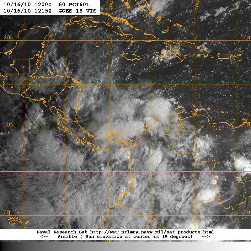
Rainfall rates N of Panama look impressive this morning...
0 likes
Carla/Alicia/Jerry(In The Eye)/Michelle/Charley/Ivan/Dennis/Katrina/Rita/Wilma/Ike/Harvey
Member: National Weather Association
Wx Infinity Forums
http://wxinfinity.com/index.php
Facebook.com/WeatherInfinity
Twitter @WeatherInfinity
Member: National Weather Association
Wx Infinity Forums
http://wxinfinity.com/index.php
Facebook.com/WeatherInfinity
Twitter @WeatherInfinity
-
cycloneye
- Admin
- Posts: 149508
- Age: 69
- Joined: Thu Oct 10, 2002 10:54 am
- Location: San Juan, Puerto Rico
Re: Disturbed area north of Panama - Code Yellow
srainhoutx wrote:Rainfall rates N of Panama look impressive this morning...
Raining hard at Panama Canal.
http://reservationsbvi.com/cam/Panama%2 ... ebCam.html
0 likes
Visit the Caribbean-Central America Weather Thread where you can find at first post web cams,radars
and observations from Caribbean basin members Click Here
and observations from Caribbean basin members Click Here

looks like most of the guidance eventually takes this into CA....while not a given it certainly seems most likely if the ridge sets up the way the globals are forecasting...A month ago I sure thought the east gulf/fl would be threatened if not hit in October but it looks more like 2010 will be the year of the non-event for the US.
0 likes
Re: Disturbed area north of Panama - Code Yellow
This bizarre permanent front is firmly in place. Reminds me of the prolonged cold snap last winter.
0 likes
-
CourierPR
- Category 5
- Posts: 1336
- Age: 72
- Joined: Tue Aug 31, 2004 7:53 pm
- Location: Pompano Beach, Florida
Re: Disturbed area north of Panama - Code Yellow
How does this relate to the disturbed area?Sanibel wrote:This bizarre permanent front is firmly in place. Reminds me of the prolonged cold snap last winter.
0 likes


Re: Disturbed area north of Panama - Code Yellow
CourierPR wrote:How does this relate to the disturbed area?
May bring dry air from north preventing significant development. Also protects the U.S coastline from this system potentially. Very November like indeed. Look at how crisp the air is from the Yucatan north throughout the entire gulf! Beautiful beach weather if you ask me
Last edited by Ntxw on Sat Oct 16, 2010 10:19 am, edited 2 times in total.
0 likes
The above post and any post by Ntxw is NOT an official forecast and should not be used as such. It is just the opinion of the poster and may or may not be backed by sound meteorological data. It is NOT endorsed by any professional institution including Storm2k. For official information, please refer to NWS products.
Help support Storm2K!
-
CourierPR
- Category 5
- Posts: 1336
- Age: 72
- Joined: Tue Aug 31, 2004 7:53 pm
- Location: Pompano Beach, Florida
Re:
I wouldn't be so hasty. I think we will see formation of a TC by Monday or Tuesday and I suspect the models will flip flop again.Vortex wrote:looks like most of the guidance eventually takes this into CA....while not a given it certainly seems most likely if the ridge sets up the way the globals are forecasting...A month ago I sure thought the east gulf/fl would be threatened if not hit in October but it looks more like 2010 will be the year of the non-event for the US.
The posts in this forum are NOT official forecast and should not be used as such. They are just the opinion of the poster and may or may not be backed by sound meteorological data. They are NOT endorsed by any professional institution or storm2k.org. For official information, please refer to the NHC and NWS products.
0 likes

Re: Re:
CourierPR wrote:I wouldn't be so hasty. I think we will see formation of a TC by Monday or Tuesday and I suspect the models will flip flop again.Vortex wrote:looks like most of the guidance eventually takes this into CA....while not a given it certainly seems most likely if the ridge sets up the way the globals are forecasting...A month ago I sure thought the east gulf/fl would be threatened if not hit in October but it looks more like 2010 will be the year of the non-event for the US.
The posts in this forum are NOT official forecast and should not be used as such. They are just the opinion of the poster and may or may not be backed by sound meteorological data. They are NOT endorsed by any professional institution or storm2k.org. For official information, please refer to the NHC and NWS products.
I agree with CourierPR... Last week the GFS continuously had a hurricane hitting South Florida as well as the Nogaps indicating a hurricane heading towards W Cuba posters here were concerned....now that the models shifted to C.A the same posters are now saying that the Conus is safe
Let everything play out....remember that there is nothing organized yet so it's not known if Richard will form....and yes just as soon as the models shifted to CA they can just as easily start shifting back to the US
0 likes
Re: Disturbed area north of Panama - Code Yellow
I agree with those who say that the US is far from being in the clear yet. Wheras the staying left over CA/MX recently modeled scenario is a reasonable possibility based on the 20% of analogs that did that, don't forget that that same climo has just over twice as many hit the US (42%). Especially with runs as recent as the Fri 12z gfs hitting S FL and considering this climo, it would be ill-advised to give up on a US hit this early.
0 likes
Personal Forecast Disclaimer:
The posts in this forum are NOT official forecasts and should not be used as such. They are just the opinion of the poster and may or may not be backed by sound meteorological data. They are NOT endorsed by any professional institution or storm2k.org. For official information, please refer to the NHC and NWS products.
The posts in this forum are NOT official forecasts and should not be used as such. They are just the opinion of the poster and may or may not be backed by sound meteorological data. They are NOT endorsed by any professional institution or storm2k.org. For official information, please refer to the NHC and NWS products.
Who is online
Users browsing this forum: Old-TimeCane and 225 guests