WPAC: MEGI (1013/15W) - Tropical Depression

Moderator: S2k Moderators

Message
Author
phwxenthusiast
Category 2
Category 2
Posts: 637
Joined: Wed Mar 24, 2010 3:10 am
Location: Holbrook, NY (Long Island)

Re:

#821 Postby phwxenthusiast » Sun Oct 17, 2010 6:07 pm

neospaceblue wrote:I have never seen TWC cover a typhoon like this before. Talked about it for three minutes at the beginning of the newscast.


whoa thanks for posting that i just turned it on and they do have a "Super Typhoon Megi Continuing Coverage"... this storm is really getting some attention due to its strength
0 likes   

supercane
S2K Supporter
S2K Supporter
Posts: 2858
Joined: Wed Sep 16, 2009 8:27 pm

#822 Postby supercane » Sun Oct 17, 2010 6:11 pm

Latest microwave:
Image
0 likes   

phwxenthusiast
Category 2
Category 2
Posts: 637
Joined: Wed Mar 24, 2010 3:10 am
Location: Holbrook, NY (Long Island)

#823 Postby phwxenthusiast » Sun Oct 17, 2010 6:14 pm

TWC just interviewed Graciano Yumul from PAGASA... amazing coverage even here in the US... just really really scary...
0 likes   

User avatar
KWT
Category 5
Category 5
Posts: 31415
Joined: Tue Aug 17, 2004 11:02 am
Location: UK!!!

#824 Postby KWT » Sun Oct 17, 2010 6:21 pm

Not at all surprised this is getting huge coverage, even for the WPAC this is a brutal storm that is coming into landfall, its going to be very similar to Zeb apart from perhaps even a smidge stronger at landfall...the system still showing no real sings of weakening into landfall so gotta assume its gonna make landfall as a 145-150kts system...just doesn't happen very often at all!
0 likes   
Personal Forecast Disclaimer:
The posts in this forum are NOT official forecast and should not be used as such. They are just the opinion of the poster and may or may not be backed by sound meteorological data. They are NOT endorsed by any professional institution or storm2k.org. For official information, please refer to the NHC and NWS products

Florida1118

Re: WPAC: MEGI - Typhoon

#825 Postby Florida1118 » Sun Oct 17, 2010 6:21 pm

I cant even Imagine...We pray for you here in Florida.
0 likes   

oaba09
S2K Supporter
S2K Supporter
Posts: 1496
Age: 38
Joined: Thu Oct 01, 2009 10:02 am
Location: Valenzuela, Philippines
Contact:

#826 Postby oaba09 » Sun Oct 17, 2010 6:32 pm

Considering how close megi is to land, it's amazing how it's eye is still so well defined.....Because of the recent WSW movement of megi, central luzon will be placed at signal # 2 later according to PAGASA....
0 likes   

User avatar
srainhoutx
S2K Supporter
S2K Supporter
Posts: 6919
Age: 67
Joined: Sun Jan 14, 2007 11:34 am
Location: Haywood County, NC
Contact:

Re: WPAC: MEGI - Typhoon

#827 Postby srainhoutx » Sun Oct 17, 2010 6:34 pm

Image
0 likes   
Carla/Alicia/Jerry(In The Eye)/Michelle/Charley/Ivan/Dennis/Katrina/Rita/Wilma/Ike/Harvey

Member: National Weather Association
Wx Infinity Forums
http://wxinfinity.com/index.php

Facebook.com/WeatherInfinity
Twitter @WeatherInfinity

User avatar
SouthDadeFish
Professional-Met
Professional-Met
Posts: 2835
Joined: Thu Sep 23, 2010 2:54 pm
Location: Miami, FL
Contact:

#828 Postby SouthDadeFish » Sun Oct 17, 2010 6:36 pm

What central pressure do yall think recon will find on the first pass?
0 likes   

euro6208

Re: WPAC: MEGI - Typhoon

#829 Postby euro6208 » Sun Oct 17, 2010 6:36 pm

I am so excited about Megi. I really wish this was headed to Guam instead.
0 likes   

User avatar
SouthDadeFish
Professional-Met
Professional-Met
Posts: 2835
Joined: Thu Sep 23, 2010 2:54 pm
Location: Miami, FL
Contact:

Re: WPAC: MEGI - Typhoon

#830 Postby SouthDadeFish » Sun Oct 17, 2010 6:37 pm

euro6208 wrote:I am so excited about Megi. I really wish this was headed to Guam instead.


No you don't. I don't know why anyone would want this. You might want to reconsider a statement like this.
0 likes   

euro6208

Re:

#831 Postby euro6208 » Sun Oct 17, 2010 6:37 pm

SouthDadeFish wrote:What central pressure do yall think recon will find on the first pass?


when is the next recon scheduled? I think there are 2 more flights for Megi but it will be after landfall...sucks!
0 likes   

Battlebrick
Tropical Storm
Tropical Storm
Posts: 177
Joined: Thu Sep 02, 2010 9:55 pm

Re:

#832 Postby Battlebrick » Sun Oct 17, 2010 6:38 pm

SouthDadeFish wrote:What central pressure do yall think recon will find on the first pass?

I don't know when they are coming out but..

If it was right now, around 885 mb. 200 kts FL.
0 likes   
Lim_Fao on IRC.

The following post is NOT an official forecast and should not be used as such. It is just the opinion of the poster and may or may not be backed by sound meteorological data. It is NOT endorsed by any professional institution including storm2k.org. For Official Information please refer to the NHC and NWS products.

User avatar
SouthDadeFish
Professional-Met
Professional-Met
Posts: 2835
Joined: Thu Sep 23, 2010 2:54 pm
Location: Miami, FL
Contact:

#833 Postby SouthDadeFish » Sun Oct 17, 2010 6:39 pm

Oh I heard they are taking off shortly, at 8 pm EST. Not sure about that though.
0 likes   

CrazyC83
Professional-Met
Professional-Met
Posts: 34002
Joined: Tue Mar 07, 2006 11:57 pm
Location: Deep South, for the first time!

#834 Postby CrazyC83 » Sun Oct 17, 2010 6:42 pm

I think they will find a slightly weaker but still amazing system. Probably supporting around 165 kt.
0 likes   

Battlebrick
Tropical Storm
Tropical Storm
Posts: 177
Joined: Thu Sep 02, 2010 9:55 pm

Re: WPAC: MEGI - Typhoon

#835 Postby Battlebrick » Sun Oct 17, 2010 6:42 pm

Are they departing from Guam, and can someone confirm the 8 pm est flight? If so, how long is the flight to the storm?
0 likes   
Lim_Fao on IRC.

The following post is NOT an official forecast and should not be used as such. It is just the opinion of the poster and may or may not be backed by sound meteorological data. It is NOT endorsed by any professional institution including storm2k.org. For Official Information please refer to the NHC and NWS products.

User avatar
SouthDadeFish
Professional-Met
Professional-Met
Posts: 2835
Joined: Thu Sep 23, 2010 2:54 pm
Location: Miami, FL
Contact:

Re:

#836 Postby SouthDadeFish » Sun Oct 17, 2010 6:43 pm

CrazyC83 wrote:I think they will find a slightly weaker but still amazing system. Probably supporting around 165 kt.


I agree. I wish this could just be a fish storm.
0 likes   

supercane
S2K Supporter
S2K Supporter
Posts: 2858
Joined: Wed Sep 16, 2009 8:27 pm

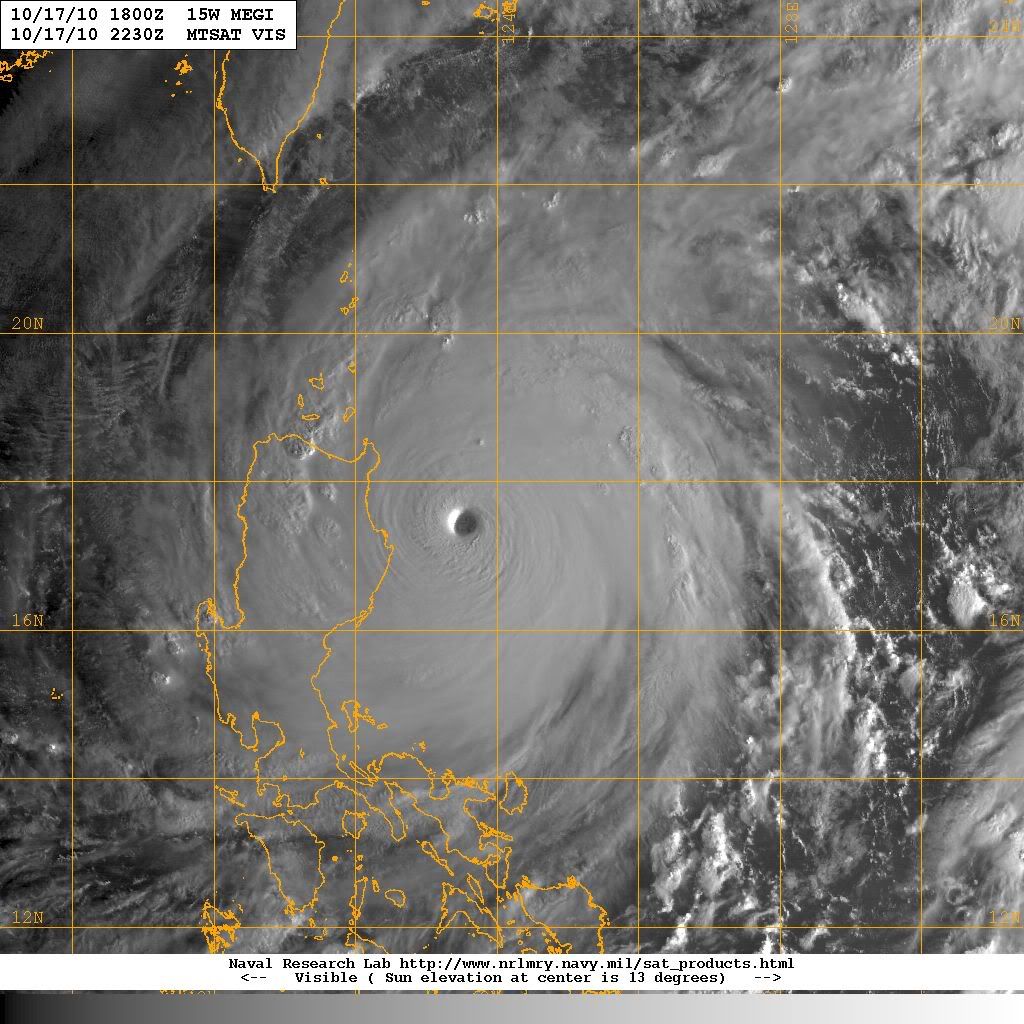
#837 Postby supercane » Sun Oct 17, 2010 6:44 pm

There will be no further recon flights into Megi, apart from one to examine the cold wake left after the storm. From ITOP, the research project that has been providing recon coverage:
PGUA 17/0100
WEATHER RESEARCH FLIGHTS
ITOP10 GUAM OPERATIONS CENTER, MARRIOTT HOTEL, TUMON, GUAM
1100 AM ChST MON 18 OCTOBER 2010
SUBJECT: ITOP10 WPAC TROPICAL CYCLONE PLAN OF THE DAY (WPTCPOD)
Valid: 18/1200Z (2200 ChST) TO 19/1159Z
WPTCPoD Number.....WP10-060a
I.- WPAC Requirements
Day 1 (AC#1) - ITOP30 MEGI WAKE I | FLT2 (AC#2) - NEGATIVE REQUIREMENTS
[A] 18/0400Z | [A]
[B] AF307 0930W MEGI | [B]
[C] 18/00Z | [C]
[D] 20.0N 125.8E EP | [D]
[E] 18/0400Z TO 18/0800Z | [E]
[F] 7,500 FT | [F]
[G] Science Crew: Heather Hornick, Pete Black, Robert Lee; Fly rear-inflow boundary layer AXCTD module across typhoon wake with six N-S 100 nm legs separated by 30 nm, oriented across cold wake; drop sondes, AXCTDs, AXCPS and AXBTs at 20 nm intervals from 7,500 ft; maintain IAS of 180 kt or less; 36 sondes, 24 AXCTDs, 7 AXCPs and 6 Hermes AXBTs in total: EP 28 20N, 125 50E; XP 28 20N, 128 20E (deg and min) | [G]
Succeeding Day OUTLOOK
Day 2 (AC#1)- ITOP30 MEGI WAKE II | FLT2 (AC#2)- NEGATIVE REQUIREMENTS
[A] 19/0400Z | [A]
[B] AF304 1030W MEGI | [B]
[C] 19/00Z | [C]
[D] 28.33N 125.83E EP | [D]
[E] 19/0400Z TO 19/0800Z | [E]
[F] 7,500 FT | [F]
[G] Science Crew: Heather Hornick, Bob Creasey; deploy 31 AXBTs in wake deployment flight with same pattern as 0930W flight. | [G]
Long Term Outlook:

GO HOME

PGUA 17/0100
WEATHER RESEARCH FLIGHTS
ITOP10 GUAM OPERATIONS CENTER, MARRIOTT HOTEL, TUMON, GUAM
1100 AM ChST MON 18 OCTOBER 2010
SUBJECT: ITOP10 WPAC TROPICAL CYCLONE PLAN OF THE DAY (WPTCPOD)
Valid: 18/1200Z (2200 ChST) TO 19/1159Z
WPTCPoD Number.....WP10-061
I.- WPAC Requirements
Day 1 (AC#1) - ITOP30 MEGI WAKE II | FLT2 (AC#2) - NEGATIVE REQUIREMENTS
[A] 19/0400Z | [A]
[B] AF304 1030W MEGI | [B]
[C] 19/00Z | [C]
[D] 20.0N 125.8E EP | [D]
[E] 19/0400Z TO 19/0800Z | [E]
[F] 7,500 FT | [F]
[G] Science Crew: Heather Hornick, Bob Creasey; deploy 31 AXBTs in wake deployment flight with same pattern as 0930W flight. | [G]
Succeeding Day OUTLOOK
Day 2 (AC#1)- | FLT2 (AC#2)- NEGATIVE REQUIREMENTS
[A] | [A]
[B] | [B]
[C] | [C]
[D] | [D]
[E] | [E]
[F] | [F]
[G] | [G]
Long Term Outlook:

GO HOME
0 likes   

User avatar
Category 5
Category 5
Category 5
Posts: 10074
Age: 35
Joined: Sun Feb 11, 2007 10:00 pm
Location: New Brunswick, NJ
Contact:

Re:

#838 Postby Category 5 » Sun Oct 17, 2010 6:47 pm

Typhoon Hunter wrote:Cheers guys, appreciate the comments.

It looks like we'll say in Aparri even if the storm tracks a little to the south. That way we'll be able to document any damage and aftermath on our travel back to Tuguegarao.


Smart move, heading for that core would be extremely risky.

Stay safe out there.
0 likes   
Image
"GAME SET MATCH GIANTS WILL WIN THE NFC EAST and have a FIRST ROUND BYE with a win next week!!!" - StormingB81, the Giants lost, and did not win the NFC east.

euro6208

Re: WPAC: MEGI - Typhoon

#839 Postby euro6208 » Sun Oct 17, 2010 6:48 pm

aw no more recon
0 likes   

User avatar
SouthDadeFish
Professional-Met
Professional-Met
Posts: 2835
Joined: Thu Sep 23, 2010 2:54 pm
Location: Miami, FL
Contact:

#840 Postby SouthDadeFish » Sun Oct 17, 2010 6:48 pm

Oh sorry for spreading that information. I got it from here:

http://twitter.com/#!/senorpepr

He posts on here.
0 likes   


Return to “2010”

Who is online

Users browsing this forum: No registered users and 9 guests