WPAC: MEGI (1013/15W) - Tropical Depression

Moderator: S2k Moderators

Message
Author
supercane
S2K Supporter
S2K Supporter
Posts: 2858
Joined: Wed Sep 16, 2009 8:27 pm

#881 Postby supercane » Sun Oct 17, 2010 8:17 pm

WTPQ50 RJTD 180000
RSMC TROPICAL CYCLONE ADVISORY
NAME TY 1013 MEGI (1013)
ANALYSIS
PSTN 180000UTC 17.5N 123.3E GOOD
MOVE W 08KT
PRES 885HPA
MXWD 125KT
GUST 175KT
50KT 110NM
30KT 350NM NORTHEAST 220NM SOUTHWEST
FORECAST
24HF 190000UTC 16.6N 119.2E 70NM 70%
MOVE W 10KT
PRES 950HPA
MXWD 080KT
GUST 115KT
48HF 200000UTC 17.0N 117.0E 110NM 70%
MOVE W SLOWLY
PRES 940HPA
MXWD 085KT
GUST 120KT
72HF 210000UTC 18.1N 115.9E 160NM 70%
MOVE NW SLOWLY
PRES 945HPA
MXWD 080KT
GUST 115KT
96HF 220000UTC 19.4N 115.1E 200NM 70%
MOVE NNW SLOWLY
120HF 230000UTC 20.8N 114.9E 260NM 70%
MOVE N SLOWLY =

Image
0 likes   

User avatar
wxman57
Moderator-Pro Met
Moderator-Pro Met
Posts: 22978
Age: 67
Joined: Sat Jun 21, 2003 8:06 pm
Location: Houston, TX (southwest)

Re: WPAC: MEGI - Typhoon

#882 Postby wxman57 » Sun Oct 17, 2010 8:18 pm

Here's a visible shot of Megi taken 0030Z when the eye was 48 miles from the coast.
Image
0 likes   

User avatar
Chacor
Category 5
Category 5
Posts: 10229
Joined: Mon Oct 02, 2006 10:43 pm
Location: Singapore

#883 Postby Chacor » Sun Oct 17, 2010 8:21 pm

JTWC's best-track has peak wind of 160 knots at 1200 UTC yesterday. Down to 145 knots right now.

For the JMA, Megi is tied for second strongest storm on record by wind (Bess 1982 125 kt; Tip 1979 140 kt) and ties for eighth by pressure. It's the strongest storm by pressure since 1984 and by wind since 1982.

The wind data is skewed though because JMA does not have wind in their BT for 1977 and earlier.
Last edited by Chacor on Sun Oct 17, 2010 8:24 pm, edited 1 time in total.
0 likes   

supercane
S2K Supporter
S2K Supporter
Posts: 2858
Joined: Wed Sep 16, 2009 8:27 pm

#884 Postby supercane » Sun Oct 17, 2010 8:23 pm

:uarrow: Actually, given those winds, wouldn't Megi be tied for second strongest in regards to wind given the current JMA 00Z advisory intensity of 125kt?
0 likes   

supercane
S2K Supporter
S2K Supporter
Posts: 2858
Joined: Wed Sep 16, 2009 8:27 pm

#885 Postby supercane » Sun Oct 17, 2010 8:27 pm

Well another ITOP flight is off from Guam, but it is scheduled to investigate the cold wake behind Megi and not tasked for recon. In addition, Megi is only 30nm from the coast now, and given its current translational speed will make landfall in several hours. The flight is sending out HDOBs, so if anyone wants to post them in the recon thread on the chance the plane gets there before landfall and does a center fix can do so. The plane is scheduled to make it around the storm vicinity by 04Z. The Google Earth program is active for the West Pac thanks to Chris_In_Tampa, but you do need to download a separate kml file from that used in the Atlantic Basin.
0 likes   

User avatar
GCANE
S2K Supporter
S2K Supporter
Posts: 11496
Joined: Mon Oct 22, 2007 8:03 am

Re: WPAC: MEGI - Typhoon

#886 Postby GCANE » Sun Oct 17, 2010 8:30 pm

Core has jumped to 7C.


Image
0 likes   

User avatar
neospaceblue
Tropical Storm
Tropical Storm
Posts: 112
Age: 32
Joined: Fri Aug 10, 2007 3:17 pm
Location: Newport News, VA

#887 Postby neospaceblue » Sun Oct 17, 2010 8:30 pm

It is terrifying to think that this ranks in the top 10 globally and is only hours from slamming into land. Prayers go out to everyone in the path.
0 likes   

User avatar
Cyclonosis
Tropical Wave
Tropical Wave
Posts: 4
Joined: Sun Oct 17, 2010 8:21 pm

Re: WPAC: MEGI - Typhoon

#888 Postby Cyclonosis » Sun Oct 17, 2010 8:31 pm

Has Megi gotten close to any WPAC intensity or pressure records?
0 likes   

User avatar
srainhoutx
S2K Supporter
S2K Supporter
Posts: 6919
Age: 67
Joined: Sun Jan 14, 2007 11:34 am
Location: Haywood County, NC
Contact:

Re: WPAC: MEGI - Typhoon

#889 Postby srainhoutx » Sun Oct 17, 2010 8:31 pm

1km zoomed...

Image
0 likes   
Carla/Alicia/Jerry(In The Eye)/Michelle/Charley/Ivan/Dennis/Katrina/Rita/Wilma/Ike/Harvey

Member: National Weather Association
Wx Infinity Forums
http://wxinfinity.com/index.php

Facebook.com/WeatherInfinity
Twitter @WeatherInfinity

Battlebrick
Tropical Storm
Tropical Storm
Posts: 177
Joined: Thu Sep 02, 2010 9:55 pm

Re:

#890 Postby Battlebrick » Sun Oct 17, 2010 8:31 pm

supercane wrote:Well another ITOP flight is off from Guam, but it is scheduled to investigate the cold wake behind Megi and not tasked for recon. In addition, Megi is only 30nm from the coast now, and given its current translational speed will make landfall in several hours. The flight is sending out HDOBs, so if anyone wants to post them in the recon thread on the chance the plane gets there before landfall and does a center fix can do so. The plane is scheduled to make it around the storm vicinity by 04Z. The Google Earth program is active for the West Pac thanks to Chris_In_Tampa, but you do need to download a separate kml file from that used in the Atlantic Basin.

Hurray!! Hopefully it'll get there before landfall...has to be in less then 4 hours, think it has a chance?
Last edited by Battlebrick on Sun Oct 17, 2010 8:32 pm, edited 1 time in total.
0 likes   
Lim_Fao on IRC.

The following post is NOT an official forecast and should not be used as such. It is just the opinion of the poster and may or may not be backed by sound meteorological data. It is NOT endorsed by any professional institution including storm2k.org. For Official Information please refer to the NHC and NWS products.

User avatar
Chacor
Category 5
Category 5
Posts: 10229
Joined: Mon Oct 02, 2006 10:43 pm
Location: Singapore

Re: WPAC: MEGI - Typhoon

#891 Postby Chacor » Sun Oct 17, 2010 8:32 pm

Cyclonosis wrote:Has Megi gotten close to any WPAC intensity or pressure records?


JMA's database has this tied-second for strongest winds (but they are lacking data prior to 1977) and tied-eighth for lowest pressure.

JTWC's best-track has this just five knots off the record (160 kt MEgi; 165 kt Tip).
0 likes   

User avatar
Chacor
Category 5
Category 5
Posts: 10229
Joined: Mon Oct 02, 2006 10:43 pm
Location: Singapore

Re: Re:

#892 Postby Chacor » Sun Oct 17, 2010 8:33 pm

Battlebrick wrote:
supercane wrote:Well another ITOP flight is off from Guam, but it is scheduled to investigate the cold wake behind Megi and not tasked for recon. In addition, Megi is only 30nm from the coast now, and given its current translational speed will make landfall in several hours. The flight is sending out HDOBs, so if anyone wants to post them in the recon thread on the chance the plane gets there before landfall and does a center fix can do so. The plane is scheduled to make it around the storm vicinity by 04Z. The Google Earth program is active for the West Pac thanks to Chris_In_Tampa, but you do need to download a separate kml file from that used in the Atlantic Basin.

Hurray!! Hopefully it'll get there before landfall...has to be in less then 4 hours, think it has a chance?

This recon flight is not scheduled to make a centre pass into Megi. Again, this is not a direct recon of the storm.
0 likes   

User avatar
GCANE
S2K Supporter
S2K Supporter
Posts: 11496
Joined: Mon Oct 22, 2007 8:03 am

Re: WPAC: MEGI - Typhoon

#893 Postby GCANE » Sun Oct 17, 2010 8:33 pm

srainhoutx wrote:1km zoomed...

Image


Looks like a large meso-vortex on the NE portion of the eye.
0 likes   

User avatar
JTE50
Category 1
Category 1
Posts: 336
Age: 67
Joined: Mon Jul 21, 2008 10:48 am
Location: Pensacola
Contact:

Re: Re:

#894 Postby JTE50 » Sun Oct 17, 2010 8:37 pm

Battlebrick wrote:
supercane wrote:Well another ITOP flight is off from Guam, but it is scheduled to investigate the cold wake behind Megi and not tasked for recon. In addition, Megi is only 30nm from the coast now, and given its current translational speed will make landfall in several hours. The flight is sending out HDOBs, so if anyone wants to post them in the recon thread on the chance the plane gets there before landfall and does a center fix can do so. The plane is scheduled to make it around the storm vicinity by 04Z. The Google Earth program is active for the West Pac thanks to Chris_In_Tampa, but you do need to download a separate kml file from that used in the Atlantic Basin.

Hurray!! Hopefully it'll get there before landfall...has to be in less then 4 hours, think it has a chance?


If the recon is a prop plane it won't make it in time -not even close to making it.
0 likes   

Typhoon10
Category 1
Category 1
Posts: 290
Age: 54
Joined: Sat Sep 12, 2009 11:55 pm
Location: Singapore

Re: WPAC: MEGI - Typhoon

#895 Postby Typhoon10 » Sun Oct 17, 2010 8:38 pm

Even HKO are predicting once moved over Philippines Megi will only lose strength to Severe Typhoon only!!!

And looking at the different tracks, once in the SCS will swing up north with some closer to Hainan Island, but more worryingly CWB putting it perilously closely to here in HK.

For forward planning, whats everyones thoughts Megi, post Philippines? What are the conditions like?
0 likes   

User avatar
Chacor
Category 5
Category 5
Posts: 10229
Joined: Mon Oct 02, 2006 10:43 pm
Location: Singapore

#896 Postby Chacor » Sun Oct 17, 2010 8:39 pm

JMA also have their five-day aimed right at Hong Kong. JTWC are further west.
0 likes   

Typhoon10
Category 1
Category 1
Posts: 290
Age: 54
Joined: Sat Sep 12, 2009 11:55 pm
Location: Singapore

Re:

#897 Postby Typhoon10 » Sun Oct 17, 2010 8:43 pm

Chacor wrote:JMA also have their five-day aimed right at Hong Kong. JTWC are further west.


Just saw that, so both JMA and CWB have it coming very close to HK. That is scary for such a populated area!
0 likes   

User avatar
wxmann_91
Category 5
Category 5
Posts: 8013
Age: 34
Joined: Fri Jul 15, 2005 2:49 pm
Location: Southern California
Contact:

Re: WPAC: MEGI - Typhoon

#898 Postby wxmann_91 » Sun Oct 17, 2010 8:46 pm

Typhoon10 wrote:Even HKO are predicting once moved over Philippines Megi will only lose strength to Severe Typhoon only!!!

And looking at the different tracks, once in the SCS will swing up north with some closer to Hainan Island, but more worryingly CWB putting it perilously closely to here in HK.

For forward planning, whats everyones thoughts Megi, post Philippines? What are the conditions like?


Megi will be torn up quite well by Luzon... two big 8000' mountain ranges to go through. So my opinion... Cat 1 when it emerges in the South China Sea. Weaker than most agencies.

Nor are conditions in the SCS as favorable as they are in the Philippine Sea, because of continental dry air and the cold NE monsoon that starts setting up around this time of year. Nevertheless, storms that get gouged out by Luzon can usually restrengthen a category or two if they remain far enough from the Asian continent. I'd say a Cat 3 secondary peak in the SCS.

Track is more tricky... we have the GFS on one end (recurvature towards Taiwan - but it's initialized too far north) vs. the Euro on the other end (track west into Hainan). I'd lean towards the latter scenario right now based on the Euro's track record, the relatively zonal nature of the upper-level flow to the north, and the possibility that Megi might weaken again as it nears the Asian mainland. Subject to change of course, and a near-stall cannot be ruled out due to competing steering influences.
Last edited by wxmann_91 on Sun Oct 17, 2010 8:50 pm, edited 2 times in total.
0 likes   

supercane
S2K Supporter
S2K Supporter
Posts: 2858
Joined: Wed Sep 16, 2009 8:27 pm

#899 Postby supercane » Sun Oct 17, 2010 8:48 pm

Model spread:
Image

12Z models:
Image

ECMWF at 144hr near Hainan Island:
Image

Synoptically, it appears fairly certain that the ridge will weaken after Megi passes through Luzon, allowing more poleward motion, but the question is to what degree? I would currently discount both the GFS and the CMC solutions calling for a sharp northerly turn, although the GFS has been persistent with it over the last several runs. NOGAPS actually has a believable solution. The Euro has been very consistent and has performed very well with Megi, so I would lean toward the UKMET/ECMWF solution of a gradual turn back to the WNW at this time. However, as the JMA graphic shows, there is still uncertainty, so it does bear watching (can we get a graphic, cycloneye [or is it Hurakan?]).

It will be interesting to see the 00Z model runs.
0 likes   

supercane
S2K Supporter
S2K Supporter
Posts: 2858
Joined: Wed Sep 16, 2009 8:27 pm

#900 Postby supercane » Sun Oct 17, 2010 8:52 pm

JTWC down to 145 kt at 03Z advisory:
WTPN31 PGTW 180300
MSGID/GENADMIN/NAVMARFCSTCEN PEARL HARBOR HI/JTWC//
SUBJ/TROPICAL CYCLONE WARNING//
RMKS/
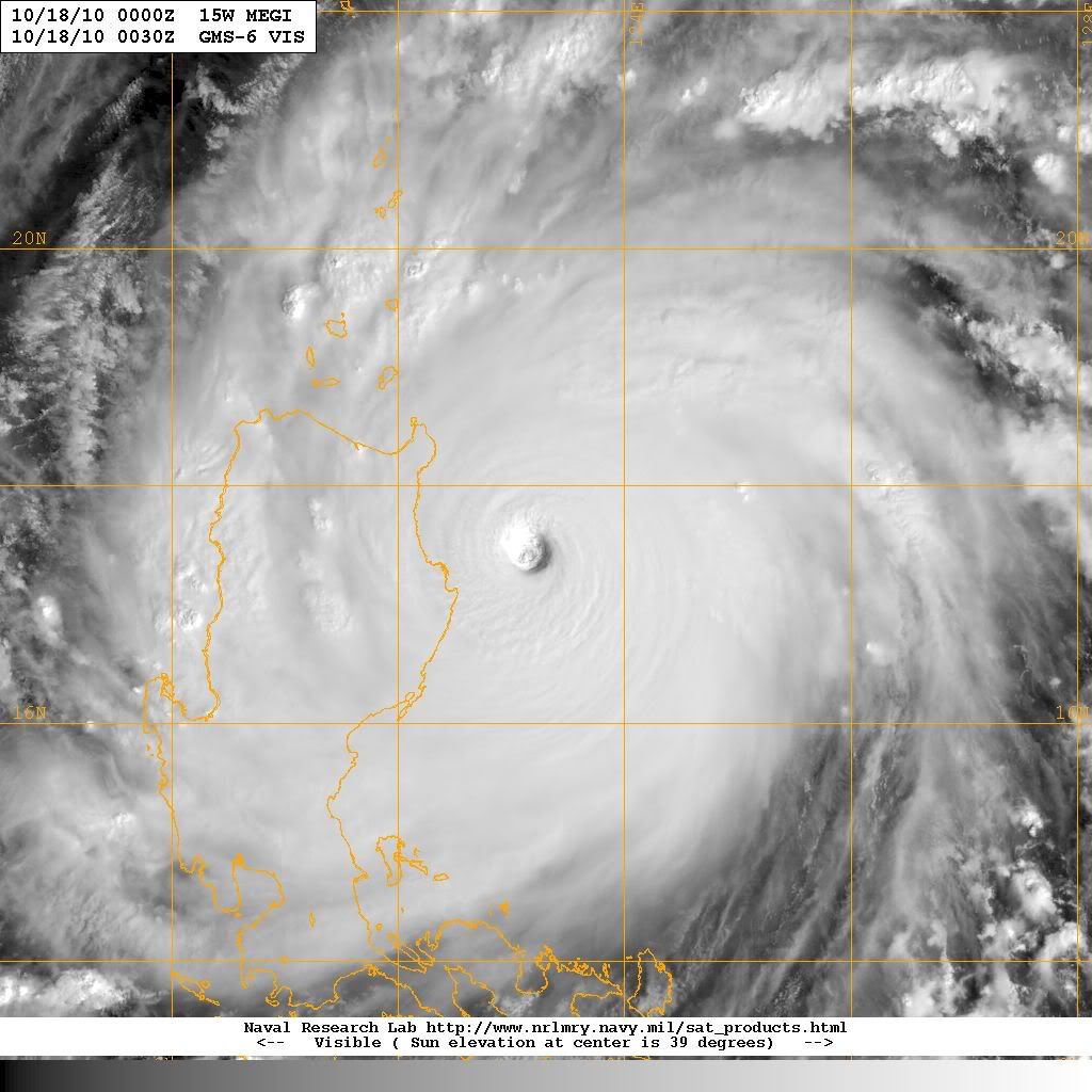
1. SUPER TYPHOON 15W (MEGI) WARNING NR 021
01 ACTIVE TROPICAL CYCLONE IN NORTHWESTPAC
MAX SUSTAINED WINDS BASED ON ONE-MINUTE AVERAGE
WIND RADII VALID OVER OPEN WATER ONLY
---
WARNING POSITION:
180000Z --- NEAR 17.5N 123.3E
MOVEMENT PAST SIX HOURS - 265 DEGREES AT 09 KTS
POSITION ACCURATE TO WITHIN 025 NM
POSITION BASED ON EYE FIXED BY SATELLITE
PRESENT WIND DISTRIBUTION:
MAX SUSTAINED WINDS - 145 KT, GUSTS 175 KT
WIND RADII VALID OVER OPEN WATER ONLY
RADIUS OF 064 KT WINDS - 060 NM NORTHEAST QUADRANT
050 NM SOUTHEAST QUADRANT
045 NM SOUTHWEST QUADRANT
055 NM NORTHWEST QUADRANT
RADIUS OF 050 KT WINDS - 095 NM NORTHEAST QUADRANT
080 NM SOUTHEAST QUADRANT
075 NM SOUTHWEST QUADRANT
085 NM NORTHWEST QUADRANT
RADIUS OF 034 KT WINDS - 150 NM NORTHEAST QUADRANT
120 NM SOUTHEAST QUADRANT
120 NM SOUTHWEST QUADRANT
140 NM NORTHWEST QUADRANT
REPEAT POSIT: 17.5N 123.3E
---
FORECASTS:
12 HRS, VALID AT:
181200Z --- 17.2N 121.2E
MAX SUSTAINED WINDS - 105 KT, GUSTS 130 KT
WIND RADII VALID OVER OPEN WATER ONLY
VECTOR TO 24 HR POSIT: 265 DEG/ 10 KTS
---
24 HRS, VALID AT:
190000Z --- 17.0N 119.2E
MAX SUSTAINED WINDS - 100 KT, GUSTS 125 KT
WIND RADII VALID OVER OPEN WATER ONLY
RADIUS OF 064 KT WINDS - 040 NM NORTHEAST QUADRANT
035 NM SOUTHEAST QUADRANT
035 NM SOUTHWEST QUADRANT
040 NM NORTHWEST QUADRANT
RADIUS OF 050 KT WINDS - 075 NM NORTHEAST QUADRANT
070 NM SOUTHEAST QUADRANT
065 NM SOUTHWEST QUADRANT
070 NM NORTHWEST QUADRANT
RADIUS OF 034 KT WINDS - 150 NM NORTHEAST QUADRANT
130 NM SOUTHEAST QUADRANT
130 NM SOUTHWEST QUADRANT
145 NM NORTHWEST QUADRANT
VECTOR TO 36 HR POSIT: 270 DEG/ 06 KTS
---
36 HRS, VALID AT:
191200Z --- 17.0N 117.9E
MAX SUSTAINED WINDS - 105 KT, GUSTS 130 KT
WIND RADII VALID OVER OPEN WATER ONLY
RADIUS OF 064 KT WINDS - 045 NM NORTHEAST QUADRANT
040 NM SOUTHEAST QUADRANT
035 NM SOUTHWEST QUADRANT
040 NM NORTHWEST QUADRANT
RADIUS OF 050 KT WINDS - 075 NM NORTHEAST QUADRANT
070 NM SOUTHEAST QUADRANT
065 NM SOUTHWEST QUADRANT
070 NM NORTHWEST QUADRANT
RADIUS OF 034 KT WINDS - 145 NM NORTHEAST QUADRANT
125 NM SOUTHEAST QUADRANT
130 NM SOUTHWEST QUADRANT
140 NM NORTHWEST QUADRANT
VECTOR TO 48 HR POSIT: 285 DEG/ 06 KTS
---
EXTENDED OUTLOOK:
48 HRS, VALID AT:
200000Z --- 17.3N 116.7E
MAX SUSTAINED WINDS - 110 KT, GUSTS 135 KT
WIND RADII VALID OVER OPEN WATER ONLY
RADIUS OF 064 KT WINDS - 045 NM NORTHEAST QUADRANT
040 NM SOUTHEAST QUADRANT
040 NM SOUTHWEST QUADRANT
045 NM NORTHWEST QUADRANT
RADIUS OF 050 KT WINDS - 075 NM NORTHEAST QUADRANT
070 NM SOUTHEAST QUADRANT
065 NM SOUTHWEST QUADRANT
070 NM NORTHWEST QUADRANT
RADIUS OF 034 KT WINDS - 140 NM NORTHEAST QUADRANT
125 NM SOUTHEAST QUADRANT
125 NM SOUTHWEST QUADRANT
140 NM NORTHWEST QUADRANT
VECTOR TO 72 HR POSIT: 295 DEG/ 04 KTS
---
72 HRS, VALID AT:
210000Z --- 18.0N 115.0E
MAX SUSTAINED WINDS - 115 KT, GUSTS 140 KT
WIND RADII VALID OVER OPEN WATER ONLY
RADIUS OF 064 KT WINDS - 045 NM NORTHEAST QUADRANT
040 NM SOUTHEAST QUADRANT
040 NM SOUTHWEST QUADRANT
045 NM NORTHWEST QUADRANT
RADIUS OF 050 KT WINDS - 075 NM NORTHEAST QUADRANT
070 NM SOUTHEAST QUADRANT
070 NM SOUTHWEST QUADRANT
070 NM NORTHWEST QUADRANT
RADIUS OF 034 KT WINDS - 140 NM NORTHEAST QUADRANT
130 NM SOUTHEAST QUADRANT
125 NM SOUTHWEST QUADRANT
135 NM NORTHWEST QUADRANT
VECTOR TO 96 HR POSIT: 310 DEG/ 04 KTS
---
LONG RANGE OUTLOOK:
NOTE...ERRORS FOR TRACK HAVE AVERAGED NEAR 250 NM
ON DAY 4 AND 350 NM ON DAY 5... AND FOR INTENSITY
NEAR 20 KT EACH DAY.
---
96 HRS, VALID AT:
220000Z --- 19.0N 113.7E
MAX SUSTAINED WINDS - 110 KT, GUSTS 135 KT
WIND RADII VALID OVER OPEN WATER ONLY
VECTOR TO 120 HR POSIT: 325 DEG/ 05 KTS
---
120 HRS, VALID AT:
230000Z --- 20.7N 112.4E
MAX SUSTAINED WINDS - 100 KT, GUSTS 125 KT
WIND RADII VALID OVER OPEN WATER ONLY
---
REMARKS:
180300Z POSITION NEAR 17.4N 122.8E.
SUPER TYPHOON (STY) 15W (MEGI) LOCATED APPROXIMATELY 220 NM
NORTHEAST OF MANILA, PHILIPPINES, HAS TRACKED WESTWARD AT 09 KNOTS
OVER THE PAST 06 HOURS. MAXIMUM SIGNIFICANT WAVE HEIGHT AT 180000Z
IS 37 FEET. NEXT WARNINGS AT 180900Z, 181500Z, 182100Z AND 190300Z.//

Image
0 likes   


Return to “2010”

Who is online

Users browsing this forum: No registered users and 3 guests