ATL: RICHARD - Remnant Low - Discussion
Moderator: S2k Moderators
-
cycloneye

- Admin

- Posts: 149123
- Age: 69
- Joined: Thu Oct 10, 2002 10:54 am
- Location: San Juan, Puerto Rico
Re:
psyclone wrote:Belize is sure dragging its feet on a hurricane warning. it seems kinda funny that there is a hurricane watch north of the border in the chetumal region and a hurricane warning for the honduran coast and no hurricane warning for belize, perhaps the highest risk area for such conditions.
They just did issue it at 2 PM.
THE GOVERNMENT OF BELIZE HAS ISSUED A HURRICANE WARNING FOR THE
COAST OF BELIZE.
0 likes
Visit the Caribbean-Central America Weather Thread where you can find at first post web cams,radars
and observations from Caribbean basin members Click Here
and observations from Caribbean basin members Click Here
-
cycloneye
- Admin
- Posts: 149123
- Age: 69
- Joined: Thu Oct 10, 2002 10:54 am
- Location: San Juan, Puerto Rico
Re: ATL : TROPICAL STORM RICHARD - Discussion
In case anyone is wondering about when is the next recon going to fly towards Richard,it departs at 4:00 PM EDT.
FLIGHT TWO -- TEAL 71
A. 24/0000Z
B. AFXXX 0919A RICHARD
C. 23/2000Z
D. 16.0N 82.8W
E. 23/2330Z TO 24/0330Z
F. SFC TO 15,000 FT
FLIGHT TWO -- TEAL 71
A. 24/0000Z
B. AFXXX 0919A RICHARD
C. 23/2000Z
D. 16.0N 82.8W
E. 23/2330Z TO 24/0330Z
F. SFC TO 15,000 FT
0 likes
Visit the Caribbean-Central America Weather Thread where you can find at first post web cams,radars
and observations from Caribbean basin members Click Here
and observations from Caribbean basin members Click Here
-
latitude_20

- Tropical Storm

- Posts: 196
- Joined: Wed Jun 30, 2010 6:46 am
- Location: Tulum, Mexico
- Contact:
Re: ATL : TROPICAL STORM RICHARD - Discussion
If Richard were to begin RI, could a turn to the northwest be possible? Any other scenarios in which sucha turn might be possible?
0 likes
-
wxman57

- Moderator-Pro Met

- Posts: 23170
- Age: 68
- Joined: Sat Jun 21, 2003 8:06 pm
- Location: Houston, TX (southwest)
Re: ATL : TROPICAL STORM RICHARD - Discussion
Squalls have really collapsed in the last 2-3 hours. Outflow now looks quite bad. It definitely isn't looking as healthy as it did earlier this morning.
0 likes
-
wxman57
- Moderator-Pro Met
- Posts: 23170
- Age: 68
- Joined: Sat Jun 21, 2003 8:06 pm
- Location: Houston, TX (southwest)
Re: ATL : TROPICAL STORM RICHARD - Discussion
latitude_20 wrote:If Richard were to begin RI, could a turn to the northwest be possible? Any other scenarios in which sucha turn might be possible?
A turn to the NW toward where? Northern Belize? That's certainly not out of the question, though it doesn't appear likely. Yucatan Channel? Nope.
0 likes
-
latitude_20
- Tropical Storm
- Posts: 196
- Joined: Wed Jun 30, 2010 6:46 am
- Location: Tulum, Mexico
- Contact:
Re: ATL : TROPICAL STORM RICHARD - Discussion
wxman57 wrote:latitude_20 wrote:If Richard were to begin RI, could a turn to the northwest be possible? Any other scenarios in which sucha turn might be possible?
A turn to the NW toward where? Northern Belize? That's certainly not out of the question, though it doesn't appear likely. Yucatan Channel? Nope.
Thanks, yeah I was thinking more along the lines of northern Belize/southern Mexico, but definitely not as far north as Cancun or the channel.
0 likes
-
cycloneye
- Admin
- Posts: 149123
- Age: 69
- Joined: Thu Oct 10, 2002 10:54 am
- Location: San Juan, Puerto Rico
Re: ATL : TROPICAL STORM RICHARD - Discussion
18z Best Track
AL, 19, 2010102318, , BEST, 0, 160N, 838W, 55, 1000, TS
ftp://ftp.tpc.ncep.noaa.gov/atcf/tcweb/ ... 010.invest
AL, 19, 2010102318, , BEST, 0, 160N, 838W, 55, 1000, TS
ftp://ftp.tpc.ncep.noaa.gov/atcf/tcweb/ ... 010.invest
0 likes
Visit the Caribbean-Central America Weather Thread where you can find at first post web cams,radars
and observations from Caribbean basin members Click Here
and observations from Caribbean basin members Click Here

Re: ATL : TROPICAL STORM RICHARD - Discussion
Just when it mixes out the dry air in front of it it draws in cooler air off the Honduras hills.
Good, if you're trying to avoid a hurricane in Belize.
Good, if you're trying to avoid a hurricane in Belize.
0 likes
-
Extratropical94

- Professional-Met

- Posts: 3545
- Age: 31
- Joined: Wed Oct 20, 2010 6:36 am
- Location: Hamburg, Germany
- Contact:
Re: ATL: RICHARD - Tropical Storm - Discussion
Richard still at 65 mph / 1000 mbar
000
WTNT34 KNHC 232034
TCPAT4
BULLETIN
TROPICAL STORM RICHARD ADVISORY NUMBER 12
NWS TPC/NATIONAL HURRICANE CENTER MIAMI FL AL192010
500 PM EDT SAT OCT 23 2010
...RICHARD MOVING WESTWARD JUST OFF THE COAST OF NORTHEASTERN
HONDURAS...
SUMMARY OF 500 PM EDT...2100 UTC...INFORMATION
----------------------------------------------
LOCATION...16.1N 84.2W
ABOUT 175 MI...280 KM E OF LA CEIBA HONDURAS
ABOUT 115 MI...185 KM ESE OF ISLA GUANAJA HONDURAS
MAXIMUM SUSTAINED WINDS...65 MPH...100 KM/HR
PRESENT MOVEMENT...W OR 280 DEGREES AT 8 MPH...13 KM/HR
MINIMUM CENTRAL PRESSURE...1000 MB...29.53 INCHES
WATCHES AND WARNINGS
--------------------
CHANGES WITH THIS ADVISORY...
NONE.
SUMMARY OF WATCHES AND WARNINGS IN EFFECT...
A HURRICANE WARNING IS IN EFFECT FOR...
* BELIZE
* HONDURAS FROM LIMON WESTWARD TO PUERTO CORTES AND THE BAY
ISLANDS...INCLUDING ROATAN...UTILA...AND GUANAJA
A HURRICANE WATCH IS IN EFFECT FOR...
* HONDURAS FROM EAST OF LIMON TO THE NICARAGUA/HONDURAS BORDER
* EAST COAST OF YUCATAN MEXICO FROM PUNTA GRUESA TO CHETUMAL
A TROPICAL STORM WARNING IS IN EFFECT FOR...
* EAST COAST OF YUCATAN MEXICO FROM PUNTA GRUESA TO CHETUMAL
* HONDURAS FROM WEST OF PUERTO CORTES TO THE HONDURAS/GUATEMALA
BORDER AND FROM EAST OF LIMON TO THE NICARAGUA/HONDURAS BORDER
TROPICAL STORM CONDITIONS ARE POSSIBLE FOR THE CARIBBEAN COAST OF
GUATEMALA.
A HURRICANE WARNING MEANS THAT HURRICANE CONDITIONS ARE EXPECTED
SOMEWHERE WITHIN THE WARNING AREA. A WARNING IS TYPICALLY ISSUED
36 HOURS BEFORE THE ANTICIPATED FIRST OCCURRENCE OF
TROPICAL-STORM-FORCE WINDS...CONDITIONS THAT MAKE OUTSIDE
PREPARATIONS DIFFICULT OR DANGEROUS. PREPARATIONS TO PROTECT LIFE
AND PROPERTY SHOULD BE RUSHED TO COMPLETION.
FOR STORM INFORMATION SPECIFIC TO YOUR AREA...PLEASE MONITOR
PRODUCTS ISSUED BY YOUR NATIONAL METEOROLOGICAL SERVICE.
DISCUSSION AND 48-HOUR OUTLOOK
------------------------------
AT 500 PM EDT...2100 UTC...THE CENTER OF TROPICAL STORM RICHARD WAS
LOCATED NEAR LATITUDE 16.1 NORTH...LONGITUDE 84.2 WEST. RICHARD IS
MOVING TOWARD THE WEST NEAR 8 MPH...13 KM/HR. THIS GENERAL MOTION
IS EXPECTED OVER THE NEXT COUPLE OF DAYS. ON THE FORECAST
TRACK...THE CENTER OF RICHARD IS EXPECTED TO PASS NEAR OR OVER THE
NORTHEASTERN COAST OF HONDURAS TONIGHT...NEAR OR OVER THE
BAY ISLANDS OF HONDURAS EARLY SUNDAY...AND COULD APPROACH THE
COASTS OF BELIZE AND SOUTHEASTERN MEXICO BY LATE SUNDAY.
MAXIMUM SUSTAINED WINDS REMAIN NEAR 65 MPH...100 KM/HR...WITH HIGHER
GUSTS. RICHARD IS FORECAST TO BECOME A HURRICANE ON SUNDAY.
TROPICAL STORM FORCE WINDS EXTEND OUTWARD UP TO 105 MILES...165 KM
FROM THE CENTER.
ESTIMATED MINIMUM CENTRAL PRESSURE IS 1000 MB...29.53 INCHES.
HAZARDS AFFECTING LAND
----------------------
STORM SURGE...A STORM SURGE WILL RAISE WATER LEVELS BY AS MUCH AS
2 TO 4 FEET ABOVE NORMAL TIDE LEVELS ALONG THE NORTHERN COAST OF
HONDURAS AND BELIZE...AND 1 TO 3 FEET IN THE BAY ISLANDS. NEAR THE
COAST...THE SURGE WILL BE ACCOMPANIED BY LARGE AND DESTRUCTIVE
WAVES.
RAINFALL...RICHARD IS EXPECTED TO PRODUCE RAINFALL ACCUMULATIONS OF
3 TO 5 INCHES OVER NORTHERN HONDURAS...THE BAY ISLANDS...AND BELIZE
WITH MAXIMUM STORM TOTAL AMOUNTS AROUND 7 INCHES. THESE RAINS
COULD PRODUCE LIFE-THREATENING FLASH FLOODS AND MUD SLIDES...
ESPECIALLY IN MOUNTAINOUS TERRAIN. RAINFALL AMOUNTS OF 1 TO 2
INCHES ARE POSSIBLE OVER NORTHEASTERN PORTIONS OF NICARAGUA.
WIND...TROPICAL STORM CONDITIONS ARE EXPECTED TO MOVE OVER
NORTHEASTERN HONDURAS WITHIN THE WARNING AREA THIS EVENING.
HURRICANE CONDITIONS ARE EXPECTED WITHIN THE WARNING AREA OF
HONDURAS EARLY SUNDAY. TROPICAL STORM CONDITIONS ARE EXPECTED
TO BEGIN ALONG THE COASTS OF BELIZE AND SOUTHEASTERN MEXICO ON
SUNDAY...WITH HURRICANE CONDITIONS EXPECTED ALONG THE COAST OF
BELIZE LATE SUNDAY.
NEXT ADVISORY
-------------
NEXT INTERMEDIATE ADVISORY...800 PM EDT.
NEXT COMPLETE ADVISORY...1100 PM EDT.
$$
FORECASTER BLAKE
0 likes
54° 11' 59'' N, 9° 9' 20'' E
Boomer Sooner!
Go Broncos! Go Cards!
Clinching counties, one at a time: https://mob-rule.com/user-gifs/USA/xtrp94.gif
- Daniel
Boomer Sooner!
Go Broncos! Go Cards!
Clinching counties, one at a time: https://mob-rule.com/user-gifs/USA/xtrp94.gif
- Daniel

Re: ATL: RICHARD - Tropical Storm - Discussion
Texas needs to pay attention to Richard.Am I politically correct in saying that Florida is now in the clear.
0 likes


Re: ATL: RICHARD - Tropical Storm - Discussion
boca wrote:Texas needs to pay attention to Richard.Am I politically correct in saying that Florida is now in the clear.
Cold front blasting through Texas midweek no chance. With the ridge in place this either goes into Mexico or flows eastward via remnants after the front rips it apart.
The following post is NOT an official forecast and should not be used as such. It is just the opinion of the poster and may or may not be backed by sound meteorological data. It is NOT endorsed by any professional institution including storm2k.org. For official information, please refer to NWS products.
0 likes
The above post and any post by Ntxw is NOT an official forecast and should not be used as such. It is just the opinion of the poster and may or may not be backed by sound meteorological data. It is NOT endorsed by any professional institution including Storm2k. For official information, please refer to NWS products.
Help support Storm2K!

-
HurricaneStriker

- Tropical Storm
- Posts: 195
- Joined: Fri Jun 25, 2010 7:23 pm
- Location: Austin, TX
-
caneman
-
HurricaneStriker
- Tropical Storm
- Posts: 195
- Joined: Fri Jun 25, 2010 7:23 pm
- Location: Austin, TX

-
SouthFloridawx

- S2K Supporter

- Posts: 8346
- Age: 47
- Joined: Tue Jul 26, 2005 1:16 am
- Location: Sarasota, FL
- Contact:
Re: ATL: RICHARD - Tropical Storm - Discussion
boca wrote:Texas needs to pay attention to Richard.Am I politically correct in saying that Florida is now in the clear.
Oh thanks a lot Boca. Now we're going to get hit.
0 likes
-
HurricaneStriker
- Tropical Storm
- Posts: 195
- Joined: Fri Jun 25, 2010 7:23 pm
- Location: Austin, TX
Re:
caneman wrote:I haven't seen any models posted in awhile. Are all of the models not doing anything with Richard any longer, after it exits the Yuc???
Based on Wunderground, GFS, GFDL, and UKMET kill it over Central America, NOGAPS and NGFDL take it into the Bay of Campeche and make it landfall over Mexico, while HWRF takes it through the Yucatan and into the Gulf and going near Florida as a tropical depression.
0 likes
217 Miles from the Texas Shore

-
srainhoutx

- S2K Supporter
- Posts: 6919
- Age: 68
- Joined: Sun Jan 14, 2007 11:34 am
- Location: Haywood County, NC
- Contact:
Re: ATL: RICHARD - Tropical Storm - Discussion
0 likes
Carla/Alicia/Jerry(In The Eye)/Michelle/Charley/Ivan/Dennis/Katrina/Rita/Wilma/Ike/Harvey
Member: National Weather Association
Wx Infinity Forums
http://wxinfinity.com/index.php
Facebook.com/WeatherInfinity
Twitter @WeatherInfinity
Member: National Weather Association
Wx Infinity Forums
http://wxinfinity.com/index.php
Facebook.com/WeatherInfinity
Twitter @WeatherInfinity

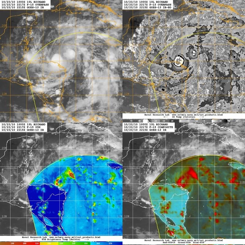
Re: ATL: RICHARD - Tropical Storm - Discussion
Is that an eye on the microwave? the recon is going to be interesting tonight.
0 likes
Who is online
Users browsing this forum: No registered users and 13 guests