SEL5
URGENT - IMMEDIATE BROADCAST REQUESTED
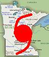
TORNADO WATCH NUMBER 725
NWS STORM PREDICTION CENTER NORMAN OK
1140 AM CDT TUE OCT 26 2010
THE NWS STORM PREDICTION CENTER HAS ISSUED A
TORNADO WATCH FOR PORTIONS OF
NORTHERN AND CENTRAL MISSISSIPPI
EFFECTIVE THIS TUESDAY MORNING AND EVENING FROM 1140 AM UNTIL 700
PM CDT.
TORNADOES...HAIL TO 1.5 INCHES IN DIAMETER...THUNDERSTORM WIND
GUSTS TO 70 MPH...AND DANGEROUS LIGHTNING ARE POSSIBLE IN THESE
AREAS.
THE TORNADO WATCH AREA IS APPROXIMATELY ALONG AND 65 STATUTE
MILES EAST AND WEST OF A LINE FROM 40 MILES NORTH NORTHWEST OF
TUPELO MISSISSIPPI TO 10 MILES SOUTH SOUTHEAST OF JACKSON
MISSISSIPPI. FOR A COMPLETE DEPICTION OF THE WATCH SEE THE
ASSOCIATED WATCH OUTLINE UPDATE (WOUS64 KWNS WOU5).
REMEMBER...A TORNADO WATCH MEANS CONDITIONS ARE FAVORABLE FOR
TORNADOES AND SEVERE THUNDERSTORMS IN AND CLOSE TO THE WATCH
AREA. PERSONS IN THESE AREAS SHOULD BE ON THE LOOKOUT FOR
THREATENING WEATHER CONDITIONS AND LISTEN FOR LATER STATEMENTS
AND POSSIBLE WARNINGS.
OTHER WATCH INFORMATION...CONTINUE...WW 721...WW 722...WW
723...WW 724...
DISCUSSION...CLEARING IN THE WAKE OF GRAVITY WAVE AND AHEAD OF COLD
FRONT HAS ALLOWED TEMPERATURES TO WARM INTO THE LOW/MID 80S. AND
WHILE MIDLEVEL LAPSE RATES ARE EXPECTED TO REMAIN POOR...THE
BOUNDARY LAYER WARMING COUPLED WITH DEW POINTS IN THE UPPER 60S TO
AROUND 70 F ARE EXPECTED TO YIELD A MODERATELY UNSTABLE ENVIRONMENT
THIS AFTERNOON WITH MLCAPE INCREASING TO 1000-2000 J/KG. WHEN
COUPLED WITH RELATIVELY STRONG LOW AND DEEP-LAYER SHEAR...SETUP WILL
FAVOR THE DEVELOPMENT OF SUPERCELLS CAPABLE OF A FEW TORNADOES IN
ADDITION TO LOCALLY DAMAGING WIND GUSTS.
AVIATION...TORNADOES AND A FEW SEVERE THUNDERSTORMS WITH HAIL
SURFACE AND ALOFT TO 1.5 INCHES. EXTREME TURBULENCE AND SURFACE
WIND GUSTS TO 60 KNOTS. A FEW CUMULONIMBI WITH MAXIMUM TOPS TO
500. MEAN STORM MOTION VECTOR 24035.
...MEAD
Plains/Midwest Windstorm and Svr. Weather (10/25 - 10/27)
Moderator: S2k Moderators
Forum rules

The posts in this forum are NOT official forecast and should not be used as such. They are just the opinion of the poster and may or may not be backed by sound meteorological data. They are NOT endorsed by any professional institution or STORM2K.
-
CrazyC83
- Professional-Met

- Posts: 34315
- Joined: Tue Mar 07, 2006 11:57 pm
- Location: Deep South, for the first time!
SEL7
URGENT - IMMEDIATE BROADCAST REQUESTED
TORNADO WATCH NUMBER 727
NWS STORM PREDICTION CENTER NORMAN OK
220 PM EDT TUE OCT 26 2010
THE NWS STORM PREDICTION CENTER HAS ISSUED A
TORNADO WATCH FOR PORTIONS OF
NORTHERN GEORGIA
FAR WESTERN NORTH CAROLINA
EASTERN TENNESSEE
FAR WESTERN VIRGINIA
EFFECTIVE THIS TUESDAY AFTERNOON AND EVENING FROM 220 PM UNTIL
1000 PM EDT.
TORNADOES...HAIL TO 1 INCH IN DIAMETER...THUNDERSTORM WIND GUSTS
TO 70 MPH...AND DANGEROUS LIGHTNING ARE POSSIBLE IN THESE AREAS.
THE TORNADO WATCH AREA IS APPROXIMATELY ALONG AND 60 STATUTE
MILES EAST AND WEST OF A LINE FROM 45 MILES SOUTH SOUTHEAST OF
CHATTANOOGA TENNESSEE TO 55 MILES NORTH OF BRISTOL TENNESSEE.
FOR A COMPLETE DEPICTION OF THE WATCH SEE THE ASSOCIATED WATCH
OUTLINE UPDATE (WOUS64 KWNS WOU7).
REMEMBER...A TORNADO WATCH MEANS CONDITIONS ARE FAVORABLE FOR
TORNADOES AND SEVERE THUNDERSTORMS IN AND CLOSE TO THE WATCH
AREA. PERSONS IN THESE AREAS SHOULD BE ON THE LOOKOUT FOR
THREATENING WEATHER CONDITIONS AND LISTEN FOR LATER STATEMENTS
AND POSSIBLE WARNINGS.
OTHER WATCH INFORMATION...CONTINUE...WW 722...WW 723...WW
724...WW 725...WW 726...
DISCUSSION...TSTMS ARE EXPECTED TO INCREASE IN COVERAGE AND
INTENSITY THIS AFTERNOON ALONG AND IN THE WAKE OF GRAVITY WAVE
PROPAGATING SEWD THROUGH THE AREA. AMBIENT AIR MASS CONTINUES TO
WARM/DESTABILIZE WITH MLCAPE VALUES NOW AROUND 500-1000 J/KG. GIVEN
THE STRONG LOW AND DEEP-LAYER SHEAR IN PLACE...ENVIRONMENT WILL BE
SUPPORTIVE OF SUPERCELLS CAPABLE OF DAMAGING WINDS AND A FEW
TORNADOES.
AVIATION...TORNADOES AND A FEW SEVERE THUNDERSTORMS WITH HAIL
SURFACE AND ALOFT TO 1 INCH. EXTREME TURBULENCE AND SURFACE WIND
GUSTS TO 60 KNOTS. A FEW CUMULONIMBI WITH MAXIMUM TOPS TO 500.
MEAN STORM MOTION VECTOR 23040.
...MEAD
0 likes

-
PTrackerLA

- Category 5

- Posts: 5281
- Age: 42
- Joined: Thu Oct 10, 2002 8:40 pm
- Location: Lafayette, LA
Re: Plains/Midwest Windstorm and Svr. Weather (10/25 - 10/27)
That pressure is astonishingly low. What causes a low to deepen so much over land like this?
0 likes
-
thetruesms

- Professional-Met
- Posts: 844
- Age: 42
- Joined: Thu Aug 16, 2007 1:14 pm
- Location: Tallahasee, FL
- Contact:
Re: Plains/Midwest Windstorm and Svr. Weather (10/25 - 10/27)
I have to admit I love recognizing the name of someone issuing products like this from school. Almost makes me feel a little connected to historysrainhoutx wrote:NOUS43 KDLH 261554
PNSDLH
MNZ010>012-018>021-026-270000-
PUBLIC INFORMATION STATEMENT
NATIONAL WEATHER SERVICE DULUTH MN
1055 AM CDT TUE OCT 26 2010
...MINNESOTA ALL TIME LOWEST PRESSURE RECORD BROKEN THIS MORNING...
...PRESSURE IS STILL FALLING AND WILL CONTINUE INTO THE AFTERNOON...
REMEMBER THAT THIS INFORMATION IS PRELIMINARY. THE LOW IS STILL
STRENGTHENING SO THE VALUES LISTED BELOW ARE LIKELY TO CHANGE.
AN UNUSUALLY INTENSE LOW WAS AFFECTING THE STATE OF MINNESOTA THIS
MORNING. AT 1013 AM CDT...THE AUTOMATED WEATHER OBSERVING SYSTEM AT
AITKIN MINNESOTA RECORDED A 962.3 MILLIBAR /28.42 INCHES/ PRESSURE.
THIS BREAKS THE ALL TIME MINNESOTA STATE RECORD FOR THE LOWEST
OBSERVED PRESSURE.
THE PREVIOUS RECORD WAS 962.6 MB SET ON NOVEMBER 10 1998 AT ALBERT
LEA AND AUSTIN IN SOUTHERN MINNESOTA.
IT SHOULD ALSO BE NOTED THAT DULUTH BROKE THEIR PRESSURE RECORD. AS
OF 1028 AM...THE PRESSURE AT DULUTH WAS 962.9 MILLIBARS /28.44
INCHES/. THIS BREAKS THE PREVIOUS RECORD OF 964.3 MILLIBARS WHICH
OCCURRED ON NOVEMBER 10 1998.
PRESSURE RECORDS AT INTERNATIONAL FALLS WERE ONLY AVAILABLE BACK TO
1948. THE LOWEST PRESSURE PREVIOUSLY AT THAT LOCATION WAS 971.9
MILLIBARS ON OCTOBER 10 1949. THE PRESSURE AS OF 1024 AM WAS 967.4
MILLIBARS /28.57 INCHES/. THEREFORE...INTERNATIONAL FALLS ALSO BROKE
THEIR PRESSURE RECORD.
THE LOW CONTINUES TO DEEPEN AND THE PRESSURE WILL LIKELY CONTINUE TO
FALL. THEREFORE...THIS STATEMENT IS PRELIMINARY AND WILL BE UPDATED
ONCE THE LOWEST PRESSURE IS FINALLY OBSERVED.
THE LOW WAS AT ABOUT 983 MB ONLY 24 HOURS AGO OVER CENTRAL SOUTH
DAKOTA. THAT IS A PRESSURE DROP OF ABOUT 21 MILLIBARS IN 24 HOURS.
$$
LAMERS
Taking it further, Bigfork (KFOZ) has unofficially recorded a new minimum, non-tropical cyclone MSLP for the US at 955.4
0 likes
-
thetruesms
- Professional-Met
- Posts: 844
- Age: 42
- Joined: Thu Aug 16, 2007 1:14 pm
- Location: Tallahasee, FL
- Contact:

-
mcallum177
- Tropical Depression

- Posts: 98
- Joined: Sun Jun 14, 2009 12:39 am
- Location: Dallas, TX
Re: Plains/Midwest Windstorm and Svr. Weather (10/25 - 10/27)
This is also much larger than a hurricane, interesting situation. The wind is not quite as strong but the pressure is just as low.
0 likes
Re: Plains/Midwest Windstorm and Svr. Weather (10/25 - 10/27)
mcallum177 wrote:The wind is not quite as strong but the pressure is just as low.
Yeah. Friction can do that.
0 likes
-
Stephanie

- S2K Supporter

- Posts: 23843
- Age: 63
- Joined: Thu Feb 06, 2003 9:53 am
- Location: Glassboro, NJ
Re: Plains/Midwest Windstorm and Svr. Weather (10/25 - 10/27)
The extreme weather is so far reaching as well - North Carolina?? Holy Cow!
0 likes
-
OverlandHurricane
- S2K Supporter
- Posts: 58
- Joined: Thu Aug 28, 2008 4:50 pm
- Location: Minnesota
Re: Plains/Midwest Windstorm and Svr. Weather (10/25 - 10/27)
International Falls, MN picked up 28.18 in/Hg (954 mbs) at 3:53 PM CDT this afternoon. That is the all-time record for low barometric pressure in Minnesota.
0 likes
-
Weather Watcher

- Tropical Storm

- Posts: 171
- Joined: Tue Aug 30, 2005 7:03 pm
- Location: Wisconsin
- Contact:
Re: Plains/Midwest Windstorm and Svr. Weather (10/25 - 10/27)
This is the scariest storm I have ever seen.
I walked out this evening to get to my car and I got to it fast for the wind took me there very fast. Yipes!
Lots of trees down. I have the chain saw in my car just in case.
Steve
I walked out this evening to get to my car and I got to it fast for the wind took me there very fast. Yipes!
Lots of trees down. I have the chain saw in my car just in case.
Steve
0 likes
-
Weather Watcher
- Tropical Storm
- Posts: 171
- Joined: Tue Aug 30, 2005 7:03 pm
- Location: Wisconsin
- Contact:
Re: Plains/Midwest Windstorm and Svr. Weather (10/25 - 10/27)
over 60,000 people in northern Wisconsin without power!
I woke up this morning and looked out and snow!I drove my son out to the bus stop and threw my first of this fall snowball at him
This storm is still here. I cannot wait till it goes.
Steve
I woke up this morning and looked out and snow!I drove my son out to the bus stop and threw my first of this fall snowball at him
This storm is still here. I cannot wait till it goes.
Steve
0 likes
-
Weather Watcher
- Tropical Storm
- Posts: 171
- Joined: Tue Aug 30, 2005 7:03 pm
- Location: Wisconsin
- Contact:
Re: Plains/Midwest Windstorm and Svr. Weather (10/25 - 10/27)
I am surprised this thread is not a big thread. This is a huge storm. The METS liken it to a hurricane but hardly no one is writing about it.
Steve
Steve
0 likes


Re: Plains/Midwest Windstorm and Svr. Weather (10/25 - 10/27)
Weather Watcher wrote:I am surprised this thread is not a big thread. This is a huge storm. The METS liken it to a hurricane but hardly no one is writing about it.
Steve
I agree, it's kinda dissapointing to see a lack of intrest in this amazing storm.
"The system's pressure was the lowest non-tropical pressure measured on the U.S. mainland -- breaking the record set during the Blizzard of 1978, according to the National Oceanic and Atmospheric Administration."
I guess with Richard gone everyone has flown south for the winter...pun intended
0 likes
Andrew '92 Opal '95 Blizzard '96 Izzy '03 Irene '11 Sandy '12
The following post is NOT an official forecast and should not be used as such. It is just the opinion is not be backed by sound meteorological data. It is NOT endorsed by any professional institution including storm2k.org For Official Information please refer to the NHC and NWS products.
The following post is NOT an official forecast and should not be used as such. It is just the opinion is not be backed by sound meteorological data. It is NOT endorsed by any professional institution including storm2k.org For Official Information please refer to the NHC and NWS products.
-
srainhoutx

- S2K Supporter
- Posts: 6919
- Age: 68
- Joined: Sun Jan 14, 2007 11:34 am
- Location: Haywood County, NC
- Contact:
Re: Plains/Midwest Windstorm and Svr. Weather (10/25 - 10/27)
Things will pick up around here as we head deeper into Fall/Winter. 
0 likes
Carla/Alicia/Jerry(In The Eye)/Michelle/Charley/Ivan/Dennis/Katrina/Rita/Wilma/Ike/Harvey
Member: National Weather Association
Wx Infinity Forums
http://wxinfinity.com/index.php
Facebook.com/WeatherInfinity
Twitter @WeatherInfinity
Member: National Weather Association
Wx Infinity Forums
http://wxinfinity.com/index.php
Facebook.com/WeatherInfinity
Twitter @WeatherInfinity

Re: Plains/Midwest Windstorm and Svr. Weather (10/25 - 10/27)
Talk about a super storm! That is one monster storm right there! I wonder if there will be more storms in the coming future like this one?
0 likes
Re: Plains/Midwest Windstorm and Svr. Weather (10/25 - 10/27)
Ptarmigan wrote:Talk about a super storm!
Well if it waits a month or two I think we're about due for a '96 style blizzard
 I know we're not "supposed" to thanks to La Nina (except the NW Coast) but hey anything can happen!
0 likes
Andrew '92 Opal '95 Blizzard '96 Izzy '03 Irene '11 Sandy '12
The following post is NOT an official forecast and should not be used as such. It is just the opinion is not be backed by sound meteorological data. It is NOT endorsed by any professional institution including storm2k.org For Official Information please refer to the NHC and NWS products.
The following post is NOT an official forecast and should not be used as such. It is just the opinion is not be backed by sound meteorological data. It is NOT endorsed by any professional institution including storm2k.org For Official Information please refer to the NHC and NWS products.
Return to “USA & Caribbean Weather”
Who is online
Users browsing this forum: wxman22 and 125 guests