I really hope the NHC doesn"t stick on this one. People in my country tend to either downplay or outright panic. in the case of the latter, we always end up with traffic jams that last 3-6 hours in this small place - valuable time that could be used for preparation.
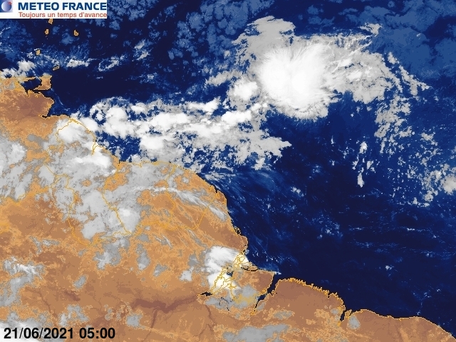
I think the system is quite impressive and the banding is clear. I appreciate the warning about rain and winds - hope the 8am TWD will give more specific details of what level of rainfall and strength of winds to expect.
ATL : EX TOMAS - Discussion
Moderator: S2k Moderators


-
cyclonic chronic

-
Blown Away

- S2K Supporter

- Posts: 10253
- Joined: Wed May 26, 2004 6:17 am
Re: ATL : INVEST 91L - Discussion

72 hour TAFB has 91L moving west, interesting!
0 likes
Hurricane Eye Experience: David 79, Irene 99, Frances 04, Jeanne 04, Wilma 05… Hurricane Brush Experience: Andrew 92, Erin 95, Floyd 99, Matthew 16, Irma 17, Ian 22, Nicole 22…
Re: ATL : INVEST 91L - Discussion
Moderate to high rain-rate along with solar heating of the cirrus will drive the vorticity down to the surface.
IMHO a good chance will see Tomas this afternoon.


IMHO a good chance will see Tomas this afternoon.
0 likes
-
hurricanefloyd5

- Category 5

- Posts: 1659
- Age: 45
- Joined: Sun May 02, 2004 10:53 am
- Location: Spartanburg
- Contact:
Re:
HURAKAN wrote:
Latest microwave
is this a or close to a hurricane according to this sat.loop scat frame here cause looks to have an eye forming there right??????????
0 likes
-
wxman57

- Moderator-Pro Met

- Posts: 23175
- Age: 68
- Joined: Sat Jun 21, 2003 8:06 pm
- Location: Houston, TX (southwest)
Re: ATL : INVEST 91L - Discussion
I must have awakened into some sort of bizzaro world where Shary is a TS with Dvorak 2.5 and 91L is only a "wave" with Dvorak 1.5. This "wave" appears to be a moderate tropical storm.
1 likes
-
HURAKAN

- Professional-Met

- Posts: 46084
- Age: 39
- Joined: Thu May 20, 2004 4:34 pm
- Location: Key West, FL
- Contact:
Re: ATL : INVEST 91L - Discussion
TROPICAL WEATHER OUTLOOK
NWS TPC/NATIONAL HURRICANE CENTER MIAMI FL
800 AM EDT FRI OCT 29 2010
FOR THE NORTH ATLANTIC...CARIBBEAN SEA AND THE GULF OF MEXICO...
THE NATIONAL HURRICANE CENTER IS ISSUING ADVISORIES ON TROPICAL
STORM SHARY...LOCATED ABOUT 220 MILES SOUTH-SOUTHWEST OF BERMUDA.
A STRONG TROPICAL WAVE LOCATED ABOUT 360 MILES EAST-SOUTHEAST OF THE
SOUTHERN WINDWARD ISLANDS HAS BECOME MUCH BETTER ORGANIZED THIS
MORNING...AND ENVIRONMENTAL CONDITIONS ARE CONDUCIVE FOR A TROPICAL
DEPRESSION OR A TROPICAL STORM TO FORM DURING THE NEXT DAY OR SO.
THERE IS A HIGH CHANCE...80 PERCENT...OF THIS DISTURBANCE BECOMING
A TROPICAL CYCLONE DURING THE NEXT 48 HOURS AS IT MOVES
WEST-NORTHWESTWARD AT 15 TO 20 MPH. REGARDLESS OF DEVELOPMENT...
THIS SYSTEM IS EXPECTED TO BRING LOCALLY HEAVY RAINFALL AND STRONG
GUSTY WINDS TO THE WINDWARD ISLANDS AND NORTHERN PORTIONS OF
VENEZUELA DURING THE NEXT COUPLE OF DAYS. AN AIR FORCE RESERVE UNIT
RECONNAISSANCE AIRCRAFT IS SCHEDULED TO INVESTIGATE THE DISTURBANCE
THIS AFTERNOON.
A WEAK LOW PRESSURE SYSTEM LOCATED ABOUT 1300 MILES WEST-NORTHWEST
OF THE NORTHERNMOST CAPE VERDE ISLANDS IS PRODUCING CLOUDINESS AND A
FEW THUNDERSTORMS. UPPER-LEVEL WINDS ARE NOT FAVORABLE FOR
DEVELOPMENT...AND THERE IS A LOW CHANCE...10 PERCENT...OF THIS
SYSTEM BECOMING A TROPICAL CYCLONE DURING THE NEXT 48 HOURS AS IT
MOVES WESTWARD NEAR 10 MPH.
ELSEWHERE...TROPICAL CYCLONE FORMATION IS NOT EXPECTED DURING THE
NEXT 48 HOURS.
PUBLIC ADVISORIES ON SHARY ARE ISSUED UNDER WMO HEADER WTNT35 KNHC
AND UNDER AWIPS HEADER MIATCPAT5. FORECAST/ADVISORIES ON SHARY ARE
ISSUED UNDER WMO HEADER WTNT25 KNHC AND UNDER AWIPS HEADER
MIATCMAT5.
$$
FORECASTER STEWART/CANGIALOSI
0 likes
-
jconsor
- Professional-Met
- Posts: 581
- Joined: Mon Jun 30, 2008 9:31 pm
- Location: Jerusalem, Israel
- Contact:
Re: ATL : INVEST 91L - Discussion
I agree it probably should have been upgraded by now. However, the center of 91L passed nearly right over a drifting buoy around 9N 52.5W about 6 hours ago and the pressure never got lower than 1007 mb:
http://coolwx.com/cgi-bin/findbuoy.cgi?id=31860
Considering pressures in that area are already fairly low, that's not very impressive.
http://coolwx.com/cgi-bin/findbuoy.cgi?id=31860
Considering pressures in that area are already fairly low, that's not very impressive.
wxman57 wrote:I must have awakened into some sort of bizzaro world where Shary is a TS with Dvorak 2.5 and 91L is only a "wave" with Dvorak 1.5. This "wave" appears to be a moderate tropical storm.
0 likes
-
Blown Away
- S2K Supporter
- Posts: 10253
- Joined: Wed May 26, 2004 6:17 am
Re: ATL : INVEST 91L - Discussion
wxman57 wrote:I must have awakened into some sort of bizzaro world where Shary is a TS with Dvorak 2.5 and 91L is only a "wave" with Dvorak 1.5. This "wave" appears to be a moderate tropical storm.
The 72 hour TAFB now shows 91L's low again, but does not tag "Possible Tropical Cyclone?" Models seem to take 91L towards DR/Jamaica, but TAFB says 91L is going west, just N of SA in 72 hours?
Wxman/Jason, what are the chances 91L makes it 80W and begins turning N and comes to SFL?
0 likes
Hurricane Eye Experience: David 79, Irene 99, Frances 04, Jeanne 04, Wilma 05… Hurricane Brush Experience: Andrew 92, Erin 95, Floyd 99, Matthew 16, Irma 17, Ian 22, Nicole 22…
-
wxman57
- Moderator-Pro Met
- Posts: 23175
- Age: 68
- Joined: Sat Jun 21, 2003 8:06 pm
- Location: Houston, TX (southwest)
Re: ATL : INVEST 91L - Discussion
jconsor wrote:I agree it probably should have been upgraded by now. However, the center of 91L passed nearly right over a drifting buoy around 9N 52.5W about 6 hours ago and the pressure never got lower than 1007 mb:
http://coolwx.com/cgi-bin/findbuoy.cgi?id=31860
Considering pressures in that area are already fairly low, that's not very impressive.wxman57 wrote:I must have awakened into some sort of bizzaro world where Shary is a TS with Dvorak 2.5 and 91L is only a "wave" with Dvorak 1.5. This "wave" appears to be a moderate tropical storm.
That buoy may have been closer before 6 hrs ago. The center is past 55W now. This is a TS if I've ever seen one.
0 likes
-
ftolmsteen

- Tropical Storm

- Posts: 122
- Joined: Mon Jun 25, 2007 6:34 am
- Location: Port Richey, FL
Re: ATL : INVEST 91L - Discussion - 8 AM TWO=Up to 80%
A trivial question... how do you pronounce Tomas? Like Thomas? Or Tow-mas?
0 likes
-
wxman57
- Moderator-Pro Met
- Posts: 23175
- Age: 68
- Joined: Sat Jun 21, 2003 8:06 pm
- Location: Houston, TX (southwest)
Re: ATL : INVEST 91L - Discussion
Blown Away wrote:The 72 hour TAFB now shows 91L's low again, but does not tag "Possible Tropical Cyclone?" Models seem to take 91L towards DR/Jamaica, but TAFB says 91L is going west, just N of SA in 72 hours?
Wxman/Jason, what are the chances 91L makes it 80W and begins turning N and comes to SFL?
Very unlikely, as all models indicate a deep trof across the SE U.S. toward the middle of next week with a SW-NE Jet core moving across Florida.
0 likes
-
HURAKAN
- Professional-Met
- Posts: 46084
- Age: 39
- Joined: Thu May 20, 2004 4:34 pm
- Location: Key West, FL
- Contact:
Re: ATL : INVEST 91L - Discussion - 8 AM TWO=Up to 80%
ftolmsteen wrote:A trivial question... how do you pronounce Tomas? Like Thomas? Or Tow-mas?
Tomás : to-MAS
Link - http://www.nhc.noaa.gov/aboutnames_pronounce_atl.shtml
0 likes
-
plasticup
Re: ATL : INVEST 91L - Discussion
wxman57 wrote:I must have awakened into some sort of bizzaro world where Shary is a TS with Dvorak 2.5 and 91L is only a "wave" with Dvorak 1.5. This "wave" appears to be a moderate tropical storm.
I looked at the satellite images this morning before checking the advisories, and thought the upgrade would have been on the other system. Why haven't they pulled the trigger on 91L?
0 likes
Who is online
Users browsing this forum: No registered users and 96 guests