
ATL : EX TOMAS - Discussion
Moderator: S2k Moderators
Re: ATL : TOMAS - Tropical Storm - Discussion
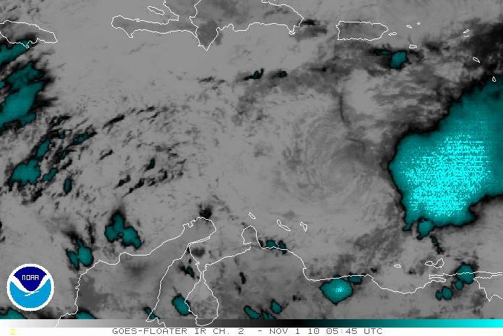
I think one look at that black IR tells you there is plenty of energy left in Tomas if the shear abates:
0 likes
-
Florida1118
Re: ATL : TOMAS - Tropical Storm - Discussion
Well you gotta give him the nice convection. Does have that Bonnie look though...
0 likes

Re: ATL : TOMAS - Tropical Storm - Discussion
Tomas is bigger than Bonnie 
Seriously, Tomas may not strngthen as much as expected before but a cat 1 can produce a disaster in Hispaniola, Noel proved that on 2007.
Seriously, Tomas may not strngthen as much as expected before but a cat 1 can produce a disaster in Hispaniola, Noel proved that on 2007.
0 likes
-
WeatherGuesser
- Category 5

- Posts: 2672
- Joined: Tue Jun 29, 2010 6:46 am
Re: Re:
SouthDadeFish wrote:wxman57 wrote:SouthDadeFish wrote:So in 18 hours Tomas went from a "tropical wave" to a hurricane.
Not quite. Tomas should have been upgraded LONG before it was, possibly 24-36 hours earlier. NHC waited until it was a rapidly-developing TS before it was named.
That's my point and why I said tropical wave in quotation marksI really hope the delay in classification didn't hinder preparations in the islands.
And in another 24 hours or so, back down to nearly nothing again instead of the Major that was forecast for a while.
0 likes


Re: ATL : TOMAS - Tropical Storm - Discussion
Perhaps everyone's prayers helped weaken the storm. Keep up the good work, we would really hate to see this thing hit Haiti as a hurricane or even a rainmaker. At this rate it may even dissipate by tomorrow night 
Anyways the Islands already took a beating from what was nearly Category 2 conditions, so this storm hasn't disappointed storm enthusiasts either, and has shown its memorable side. I don't think many of you in the Leewards will soon forget Tomas.
Anyways the Islands already took a beating from what was nearly Category 2 conditions, so this storm hasn't disappointed storm enthusiasts either, and has shown its memorable side. I don't think many of you in the Leewards will soon forget Tomas.
0 likes
Georges '98, Irene '99, Frances '04, Jeanne '04, Katrina '05, Wilma '05, Gustav '08, Isaac '12, Matthew '16, Florence '18, Michael '18, Ian '22
-
Florida1118
Re: ATL : TOMAS - Tropical Storm - Discussion
FireRat wrote:Perhaps everyone's prayers helped weaken the storm. Keep up the good work, we would really hate to see this thing hit Haiti as a hurricane or even a rainmaker. At this rate it may even dissipate by tomorrow night
Anyways the Islands already took a beating from what was nearly Category 2 conditions, so this storm hasn't disappointed storm enthusiasts either, and has shown its memorable side. I don't think many of you in the Leewards will soon forget Tomas.
But what I'm thinking, If it dissipates, Will the energy stay in the Caribbean? If it does, all you need is a low and boom, Virginie is born.
0 likes
-
dwsqos2
Re: ATL : TOMAS - Tropical Storm - Discussion
Strong winds undercutting the outflow layer tend to be a good way to disrupt storms. See Erika 2009, or more recently Richard's struggles. I don't think prayer had much of anything to do with this.
0 likes
-
Florida1118
Re: ATL : TOMAS - Tropical Storm - Discussion
dwsqos2 wrote: I don't think prayer had much of anything to do with this.
Lets not get into that....
0 likes


Re: ATL : TOMAS - Tropical Storm - Discussion
Florida1118 wrote:But what I'm thinking, If it dissipates, Will the energy stay in the Caribbean? If it does, all you need is a low and boom, Virginie is born.
Troughs are digging deeper and deeper pushing the hostile conditions further south each time. The western Caribbean is slowly becoming the gulf dead zone. As time progresses, scenarios as such becomes less and less likely.
0 likes
The above post and any post by Ntxw is NOT an official forecast and should not be used as such. It is just the opinion of the poster and may or may not be backed by sound meteorological data. It is NOT endorsed by any professional institution including Storm2k. For official information, please refer to NWS products.
Help support Storm2K!

-
dwsqos2
Re: ATL : TOMAS - Tropical Storm - Discussion
Random, but as has been noted a weaker storm will be steered by the low-level flow, which in this case would result in a more westerly motion
(not always the case, weak does not always mean west). A more southerly track would allow Tomas to avoid some of the stronger shear.
00Z gfs was actually a hair stronger with Tomas than the 18Z run.
Pressures have dropped a bit at the relevant buoy (42059). Winds are still anemic, but just under tropical storm force.
Supplemental Measurements Highest 1-minute Wind Speed
Time (ADT) WSPD WDIR
1:06 am 31.5 kts ENE ( 76 deg true)
Last edited by dwsqos2 on Mon Nov 01, 2010 12:17 am, edited 2 times in total.
0 likes
It's nice to believe that our wishes for the better are coming true at least as of now, especially after the apocalyptic forecast this storm had just yesterday for these days. The shear came to the rescue.
As for future storms, we still can't rule out more in the Caribbean before November 30. November 25 might be the last time frame a hurricane could exist this season close enough to threaten land, then a weak tropical storm in December far out at sea. For now it's looking good with Tomas and I really hope Haiti dodges a bullet, they've had way too many tragedies to even conceive a hurricane landfall. Oh and Virginie, well with that cute sounding name I bet it won't be much of a scare
Walter, however, gives me the creeps for some reason.
0 likes
Georges '98, Irene '99, Frances '04, Jeanne '04, Katrina '05, Wilma '05, Gustav '08, Isaac '12, Matthew '16, Florence '18, Michael '18, Ian '22
Re: ATL : TOMAS - Tropical Storm - Discussion

0 likes
The above post and any post by Ntxw is NOT an official forecast and should not be used as such. It is just the opinion of the poster and may or may not be backed by sound meteorological data. It is NOT endorsed by any professional institution including Storm2k. For official information, please refer to NWS products.
Help support Storm2K!
Help support Storm2K!
-
Shuriken
Fully exposed LLC now, racing WSW at about 260 or so. The danger now is that the system continues darting WSW past Venezuela into the "pocket" of the southwestern Caribbean, where it'll have more "running room" for a northward sling out -- or perhaps be missed by the next trough entirely, and stew for longer than anyone imagines.
0 likes
-
WeatherGuesser
- Category 5
- Posts: 2672
- Joined: Tue Jun 29, 2010 6:46 am


-
WeatherGuesser
- Category 5
- Posts: 2672
- Joined: Tue Jun 29, 2010 6:46 am

Re: ATL : TOMAS - Tropical Storm - Discussion
Tomas has been suffering from a displaced anti-cyclone since Friday due to a strong MCS that fired to his east.
Tomas also has a strong boundary-layer inversion which is putting a lid on parcel ascent near the LLC; aka convective cap.
To get the anti-cyclone to move closer to the LLC, deep convection with high rain-rate needs to fire close to the LLC.
Latent heating will raise the tropopause and get the PV column to expand and become more verically aligned.
This most likely could break the convective cap.
If that happens, it would be like one of those massive afternoon MCS's in OK in the spring and you could see this explode.
So, watch for a high rain-rate cell, in fact a hot-tower could snap every thing in place.
If that breaks the convective cap, everyone's mood will suddenly change.
Moving into high OHC in the next 24 hrs.
0 likes

Who is online
Users browsing this forum: No registered users and 43 guests