Just saw this online at the Miami Herald. Good to see someone is taking it seriously and getting the word out. With all these people in tents, communication and logistics are going to be crucial.
http://www.miamiherald.com/2010/11/01/1 ... tomas.html
Lets pray for them to be spared but even a major rain event could be devastating.
Caribbean - Central America Weather
Moderator: S2k Moderators
Forum rules

The posts in this forum are NOT official forecast and should not be used as such. They are just the opinion of the poster and may or may not be backed by sound meteorological data. They are NOT endorsed by any professional institution or STORM2K.
-
andrewsurvivor
- Tropical Low

- Posts: 43
- Age: 69
- Joined: Mon Aug 02, 2010 11:45 am
- Location: So.Florida
-
cycloneye

- Admin

- Posts: 149719
- Age: 69
- Joined: Thu Oct 10, 2002 10:54 am
- Location: San Juan, Puerto Rico
Re: Caribbean - Central America - (Tomas in Central Caribbean)
andrewsurvivor wrote:Just saw this online at the Miami Herald. Good to see someone is taking it seriously and getting the word out. With all these people in tents, communication and logistics are going to be crucial.
http://www.miamiherald.com/2010/11/01/1 ... tomas.html
Lets pray for them to be spared but even a major rain event could be devastating.
Good to see that they are on alert. Hopefully,Tomas dissipates and Haiti is spared.
0 likes
Visit the Caribbean-Central America Weather Thread where you can find at first post web cams,radars
and observations from Caribbean basin members Click Here
and observations from Caribbean basin members Click Here
-
cycloneye
- Admin
- Posts: 149719
- Age: 69
- Joined: Thu Oct 10, 2002 10:54 am
- Location: San Juan, Puerto Rico
Re: Caribbean - Central America - (Tomas in Central Caribbean)
AREA FORECAST DISCUSSION
NATIONAL WEATHER SERVICE SAN JUAN PR
301 PM AST MON NOV 1 2010
.SYNOPSIS...TROPICAL STORM TOMAS CONTINUES MOVING AWAY FROM THE
LOCAL WATERS TONIGHT. HIGH PRESSURE NORTH OF THE AREA WILL
MAINTAIN STRONG EAST WINDS ACROSS THE LOCAL AREA.
&&
.DISCUSSION...SHOWERS WHICH DEVELOPED THIS AFTERNOON HAS BEEN
MAINLY DUE TO DAYTIME HEATING...AND THE COMBINATION OF AVAILABLE
MOISTURE AND OROGRAPHIC EFFECTS. TROPICAL STORM TOMAS HAS WEAKENED
CONSIDERABLY THE LAST 24 HOURS...ALTHOUGH LATEST SATELITE IMAGES
SHOWS A RAPID INCREASE IN SHOWERS AND THUNDERSTORMS NEAR THE LOW
LEVEL CENTER. MODELS SHOWS A SLIGHT DECREASE IN MOISTURE ACROSS
THE LOCAL AREA...AS TOMAS MOVE FURTHER AWAY FROM THE LOCAL AREA.
OUR MAIN CONCERN IN THE SHORT TERM RANGE ARE THE MARINE CONDITIONS
FOR THE COASTAL WATERS WITH SMALL CRAFT ADVISORIES FOR THE
SOUTHERN COASTAL WATERS THROUGH TOMORROW. IN FACT...BUOY 42085
LOCATED JUST OFFSHORE SOUTH OF PONCE...IS SHOWING ALREADY LESS
THAN 6 FEET. MARINE CONDITIONS ARE GOING TO IMPROVE SLIGHTLY...BUT
WINDS WILL KEEP SEAS NEAR 6 FEET ACROSS ALL COASTAL WATERS.
THEREFORE...SMALL CRAFT SHOULD EXERCISE CAUTION.
IN THE LONG TERM...WEATHER CONDITIONS ACROSS THE LOCAL AREA WILL
BE DETERMINED BY THE FUTURE INTENSITY AND TRACK OF TOMAS. LATEST
COMPUTER MODELS SUGGESTS TOMAS WILL STALL SOUTH OF HISPANIOLA THE
NEXT FEW DAYS...AND WILL START TO MOVE TOWARD THE NORTH AND
NORTHEAST LATER THIS WEEK...AS A DEEP TROUGH MOVES ACROSS THE
WESTERN CARIBBEAN.
&&
.AVIATION...POSSIBLE MVFR CIGS AT JBQ/JMZ WITH VCTS. OTHERWISE...VFR
CONDITIONS AT ALL OTHER TAF SITES.
0 likes
Visit the Caribbean-Central America Weather Thread where you can find at first post web cams,radars
and observations from Caribbean basin members Click Here
and observations from Caribbean basin members Click Here
-
cycloneye
- Admin
- Posts: 149719
- Age: 69
- Joined: Thu Oct 10, 2002 10:54 am
- Location: San Juan, Puerto Rico
Re: Caribbean - Central America - (Tomas in Central Caribbean)
Good morning.We here in Puerto Rico and VI will have to watch the tail of Tomas by the weekend.
AREA FORECAST DISCUSSION
NATIONAL WEATHER SERVICE SAN JUAN PR
524 AM AST TUE NOV 2 2010
.SYNOPSIS...AT UPPER LEVELS...HIGH PRESSURE REMAINS OVER THE CARIBBEAN
FOR THE ENTIRE PERIOD BUT ALSO EXTENDS NORTH OF PUERTO RICO OVER
NEXT WEEKEND AND MONDAY AND TUESDAY.
AT MID LEVELS...EXCEPT FOR TROPICAL STORM TOMAS...HIGH PRESSURE
REMAINS IN THE SOUTHWEST CARIBBEAN. A DEEP LONG WAVE TROUGH AT
BOTH UPPER AND MID LEVELS WILL EXTEND SOUTH INTO THE GULF OF
MEXICO ON FRIDAY CAUSING THE HIGH TO MOVE NORTHEAST OF THE U.S.
VIRGIN ISLANDS. BUT IT WILL RE-FORM EARLY NEXT WEEK OVER CENTRAL
AMERICA AFTER THE TROUGH PULLS NORTHEAST.
AT LOWER LEVELS...HIGH PRESSURE OVER THE GREAT LAKES WILL MOVE
INTO THE WESTERN ATLANTIC AND BUT THIS WILL CAUSE SURFACE PRESSURE
TO FALL SOMEWHAT OVER PUERTO RICO AS THE HIGH AROUND 28 NORTH IS
ABSORBED. TROPICAL STORM TOMAS IS EXPECTED TO MOVE WEST FOR A FEW
DAYS AND THEN TURN DRAMATICALLY NORTHWARD WHEN THE MID AND UPPER
LEVEL TROUGH DIGS INTO THE GULF OF MEXICO. DEPENDING ON THE EXACT
LOCATION OF THIS TROUGH...THE TROPICAL CYCLONE COULD LINGER IN THE
AREA TO OUR NORTH THROUGH EARLY NEXT WEEK.
&&
.DISCUSSION...A RAIN BAND FROM THE NORTHERN OUTER PERIPHERY OF
TROPICAL STORM TOMAS HAS BEEN FIRING SHOWERS AND POSSIBLY A FEW
THUNDERSTORMS IN THE SOUTHERN MOST REACHES OF OUR OUTER CARIBBEAN
WATERS. THESE DO NOT APPEAR AS THOUGH THEY WILL ADVANCE TOWARD THE
ISLANDS ANY FURTHER. A WEAK FRONTAL BOUNDARY AS NOTED BY THE
5 DEGREE DEWPOINT DECREASE IN THE LAST 12 TO 15 HOURS AT BUOY
41043 IS ALSO CREATING SHOWERS OVER THE LOCAL OUTER ATLANTIC
WATERS. A FEW OF THESE HAVE ALREADY MOVED ON SHORE. THIS WILL KEEP
ISOLATED TO SCATTERED SHOWERS IN THE FORECAST FOR THE NORTHERN
COAST. THEN CONVERGENCE AND DAYTIME HEATING WILL ADD ENERGY TO THE
CONVECTION OVER LAND WHICH WILL DEVELOP IN THE EAST NORTHEAST FLOW
OVER SOUTHWEST AND INTERIOR PUERTO RICO. EXPECT SHOWERS TO
POSSIBLY FORM AS FAR EAST AS EL YUNQUE AS THEY MOVE WEST
SOUTHWEST. SHOWERS CONTINUE TO DEVELOP OVER THE AREA IN A SIMILAR
MANNER WHILE FLOW MOVES INTO TROPICAL STORM TOMAS OVER THE CENTRAL
CARIBBEAN. SHOWERS ARE LIKELY TO INCREASE IF TOMAS MOVES NORTHWEST
AND THEN NORTH OF THE AREA BEGINNING NEXT FRIDAY...BUT...TIMING
AND TRACK OF TOMAS BECOME VERY UNCERTAIN AT THAT TIME AND
CONFIDENCE IN ANY PARTICULAR SCENARIO REMAINS LOW. SHOULD TOMAS
COME CLOSE ENOUGH...WINDS COULD INCREASE AGAIN OVER PUERTO RICO
AND POSSIBLY THE NORTHERN U.S. VIRGIN ISLANDS...BUT SHOWERS FRIDAY
THROUGH SUNDAY OR EVEN TUESDAY IN CONVERGENCE INTO THE CYCLONE TO
THE NORTH IS THE MORE LIKELY OUTCOME REGARDLESS OF THE VAGARIES
OF THE TRACK OR THE RAPIDITY WITH WHICH IT EVENTUALLY MOVES
NORTHEAST AND AWAY FROM THE AREA.
&&
.AVIATION...
VFR CONDS ARE EXPECTED ACROSS ALL TAF SITES THROUGH THE FORECAST
PERIOD...WITH VCSH POSSIBLE ACROSS TIST... TISX...TNCM AND TKPK.
SHWRS AND ISOLD TSRA WILL DEVELOP AFT 02/16Z OVER THE CORDILLERA
CENTRAL AND SOUTHWEST PR...RESULTING IN PERIODS OF MVFR CONDS AND
MOUNTAIN OBSCURATIONS ACROSS TJMZ AND POSSIBLE TJPS. WINDS WILL BE
MAINLY FROM THE EAST NORTHEAST AT 10 TO 20 KTS.
&&
.MARINE...SEAS REMAIN AGITATED FROM TROPICAL STORM TOMAS...BUT
SHOULD DIMINISH IN THE OUTER CARIBBEAN WATERS AT NOON AS THE
TROPICAL CYCLONE MOVES FARTHER WEST. WHEN IT MOVES NORTH AND THEN
NORTHEAST SMALL CRAFT ADVISORIES WILL AGAIN BE NEEDED.
0 likes
Visit the Caribbean-Central America Weather Thread where you can find at first post web cams,radars
and observations from Caribbean basin members Click Here
and observations from Caribbean basin members Click Here
-
Gustywind

- Category 5

- Posts: 12334
- Joined: Mon Sep 03, 2007 7:29 am
- Location: Baie-Mahault, GUADELOUPE
Tomas spins the Caribbean
franceantilles.fr 01.11.2010
 http://www.microsofttranslator.com/bv.a ... -90799.php
After having crossed the Caribbean arc this weekend, Tomas continues its road in the Caribbean and poses a grave threat to Haiti.
Tomas, demoted Sunday evening in tropical storm has weakened but should regain forces again tomorrow.
It is moving toward the Northwest. For the moment cannot know with certainty whether it will hit Haiti, the Jamaica or Cuba.
Phenomenon advances about 20 kilometres per hour on the Caribbean and its trajectory provides wire to challenge the forecasters who are considering it again touches land inhabited Thursday.
Tomas crossed arc Caribbean Saturday between Saint Lucia and Saint Vincent displaying blowers winds in excess of 120 km/h.
Less powerful than the previous cyclone to hit the small antilles (Dean and Ivan in particular), caused significant damage in our neighbours to the South because of developed to evacuate to the Caribbean. Tomas has indeed remained stationary for several hours on top of the Islands
More than wind, they are the water spouts which have caused damage, primarily in the South of St. Lucia. According to media sainte-Lucia, dozens of houses were destroyed. Networks (road, water and electricity) have also suffered. Saint-Lucien Government evokes a period of two to three weeks of work to see the road network and in particular Road West find its normal state.
No human victim would be a regrettable.
Before touching the Caribbean arc, Tomas caused material damage to electricity in Barbados according the u.s. national hurricane (NHC).
franceantilles.fr 01.11.2010
After having crossed the Caribbean arc this weekend, Tomas continues its road in the Caribbean and poses a grave threat to Haiti.
Tomas, demoted Sunday evening in tropical storm has weakened but should regain forces again tomorrow.
It is moving toward the Northwest. For the moment cannot know with certainty whether it will hit Haiti, the Jamaica or Cuba.
Phenomenon advances about 20 kilometres per hour on the Caribbean and its trajectory provides wire to challenge the forecasters who are considering it again touches land inhabited Thursday.
Tomas crossed arc Caribbean Saturday between Saint Lucia and Saint Vincent displaying blowers winds in excess of 120 km/h.
Less powerful than the previous cyclone to hit the small antilles (Dean and Ivan in particular), caused significant damage in our neighbours to the South because of developed to evacuate to the Caribbean. Tomas has indeed remained stationary for several hours on top of the Islands
More than wind, they are the water spouts which have caused damage, primarily in the South of St. Lucia. According to media sainte-Lucia, dozens of houses were destroyed. Networks (road, water and electricity) have also suffered. Saint-Lucien Government evokes a period of two to three weeks of work to see the road network and in particular Road West find its normal state.
No human victim would be a regrettable.
Before touching the Caribbean arc, Tomas caused material damage to electricity in Barbados according the u.s. national hurricane (NHC).
0 likes


Re: Caribbean - Central America - (Tomas in Central Caribbean)
Good morning
I thought you might be interested in these pictures and these videos from St. Lucia which got hit pretty hard from Tomas
http://www.facebook.com/photo.php?fbid= ... 3712035193
http://www.htsstlucia.com/HTS_News_Video5.html
http://www.youtube.com/watch?v=GhvO1SRnwxc
I am praying for the people of Haiti not to be in the way of this storm.
0 likes
Too many hurricanes to remember
-
Gustywind
- Category 5
- Posts: 12334
- Joined: Mon Sep 03, 2007 7:29 am
- Location: Baie-Mahault, GUADELOUPE
Re: Caribbean - Central America - (Tomas in Central Caribbean)
msbee wrote:Good morning
I thought you might be interested in these pictures and these videos from St. Lucia which got hit pretty hard from Tomas
http://www.facebook.com/photo.php?fbid= ... 3712035193
http://www.htsstlucia.com/HTS_News_Video5.html
http://www.youtube.com/watch?v=GhvO1SRnwxc
I am praying for the people of Haiti not to be in the way of this storm.
0 likes
Re: Caribbean - Central America - (Tomas in Central Caribbean)
0 likes
Too many hurricanes to remember
-
Gustywind
- Category 5
- Posts: 12334
- Joined: Mon Sep 03, 2007 7:29 am
- Location: Baie-Mahault, GUADELOUPE
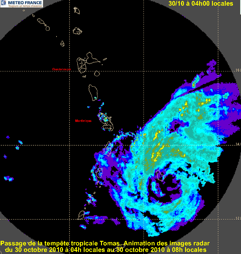
Here is a complete and informative summary of TOMAS episode after its nasty trip on Guadeloupe... As a conclusion, you can see you how a "small" (so vicious  ) CAT 1 CANE can have serious effects on the islands
  , even those who are situated 200 or 300 km further north of the system as Guadeloupe. Let's hope that this feature will the last one of the season, REALLY! But as you know, anything can happens in the Tropics, wait and see. Keep the faith for the others, prayers and best thoughts from our carib heart my neighbours in all the carib:)
http://www.microsofttranslator.com/bv.a ... -99933.php
TOMAS shook the region
V. d. France-French West Indies Guadeloupe 02.11.2010
The coast of the South of the archipelago suffered a heavy swell, here at Anse-Vinaigri. 5.5 Metre troughs have been recorded at Grande Vigie. (STÉPHANE SISCO)
Little thunderstorm, but heavy rain, wind gusts and marked swells, especially in the South of the archipelago. The passage of cyclone Tomas region did little damage in Guadeloupe. Martinique, St. Lucia, Barbados were more seriously affected. Hurricane strengthens toward Haiti.
Sunday morning, Guadeloupe is awakened in the '' grey in vigilance weather yellow level for "rains, thunderstorms, strong winds and rough seas. For Norbert Aouizerats, head of centre at weather France, "the tendency was to improve", Tomas cyclone evacuated to the West. In the day the wind fell and swell has been less while rain disappearing.
The cyclone season sometimes have a trajectory erratic, and therefore not easily predictable. Lee-Windward coast remembers Omar in October 2008... But Tomas broadly followed the planned path. "He stayed in the South, quite far from home, then took the direction West-North-West". Now it is quiet. "12: 00 Sunday, weather France newsletter announced a return to the Green level of vigilance.
Wind: 94 km to Baillif
In contrast to Martinique, strongly affected by the passage of cyclone Tomas in the South of the Caribbean arc (read below), Guadeloupe had been generally spared by the phenomenon. She however suffered in the peripheral effects. Particularly the archipelago South: Basse-Terre, South coast south of Saint-François (Pointe des Châteaux), Sainte-Anne and Le Gosier. Thunderstorm activity was low, but numerous showers. 119 mm ((1) precipitation was recorded at portion, 76 mm to 75 mm in Basse-Terre, 64 mm at Sainte-Anne, 54 mm Baie-Mahault, Pointe-Noire 42 mm at Saint-François and Baillif.)
Enough sustained winds were recorded: 94 km/h at Baillif, 83 km/h at La Desirade, 61 km/h at Sainte-Anne and 79 km/h at the Raizet. And a strong swell swept on some shores. Troughs of 5, 5 m were observed at the Grande Vigie buoy. Norbert Aouizerats said they were able to 6 to 6.5 metres at sea.
The range of the Toubana suffered storm hit (S.S.) (1) 1 mm = 1 litre per square metre.
-Big damage to Barbados, St. Lucia and St. Vincent
Pulled roofs, houses damaged power lines on the ground, flooded roads. With its (120 km/h) winds and torrential rains, Tomas cyclone caused major damage, Saturday, Barbados, St. Lucia and St. Vincent. In Saint Lucia, according to information communicated to the association contacts and research Caribbean (CORECA) by one of its corresponding "several public schools have been damaged." Many houses are out of use, leaving some families homeless. "Island is private electricity and communications remain difficult.
-60_000 homes without electricity in Martinique
Hurricane Tomas left traces in Martinique. According to EDF, 60000 customers have been deprived of electricity between Saturday and Sunday. All municipalities in the North and South, with the exception of those in the centre of the island, have been affected. Yesterday evening, hundreds of homes were still not light. Disturbances were also announced in air traffic. RN 5, completely flooded, was cut to Rivière Salée for two hours and a deviation has been implemented. Three families had to be relocated and a car was swept away by the flood.
20-70% of the bananas were lying by storm in the North Atlantic. At the level of the cane, the damage is limited. Canes should leave by harvest, but this episode will affect its quality.
-Emergency in Haiti
Tomas, demoted Sunday evening in tropical storm is weakened, but should regain forces again today. It is moving toward the Northwest. Weather services in the country, Tomas could hit Haiti within next 72 hours with heavy rains and high winds, potentially causing often deadly landslides. Haiti faces currently a cholera epidemic (337 deaths counted) and thousands of people are still refugees in villages in tents since the earthquake of 12 January. UN agencies have indicated to be all of their assistance to populations who may be affected. They have particular routed in certain areas of the country enough fuel for a week where roads become impassable. Haitian, UN agencies and non-governmental organizations (NGOs) authorities work together to pré-positionner stocks help and prepare to cope with hurricane. The International Red Cross sent material in 13 locations in Haiti to 25000 families.
Saint-Lucia: tourists stranded at the airport
The voltage is mounted to one notch yesterday afternoon at the airport in Castries Saint Lucia. Air Caribbean, passengers whose flights have been suspended, have invested the counter of the company, particularly hauled.
"What you want, is to be informed and that cared for us, explains David Baudoin, French tourists whose family lived in Guadeloupe. Since Saturday, they are 80 people, tourists guadeloupian, Martinique and metropolitan, to be stranded at the airport. Air Caribbean failing to support nights hotel, difficult for these families to find a solution for shelter.
"Those who have failed to find shelter had to sleep in their car rental or altogether outside, says David Baudoin." We are well aware of the seriousness of the situation in Saint Lucia, but Sunday, the company should provide additional flights. "Other companies, such as the Liat have adapted. Yesterday, in the middle of the afternoon, tourists have learned that an exceptional flight was chartered in the evening, at 20: 55 in the direction of Fort-de-France, in addition to the scheduled flight. A good part of the travellers had still to unravel a night more.
"We have done with the edge means says Véronique Malialin, charge Air Caribbean communication." This weekend all saints, all our flights were complete and our aircraft incurred between France Fort and Pointe-à-Pitre. "We were obliged to meet scheduled flights.
Extra flights are normally scheduled today so that the last French tourists leave Saint Lucia.
-GUIDES
Disturbed inter-island connections
Consequence of choppy, interruption Saturday maritime rotations, including between France Fort and Guadeloupe and Marie-Galante and Pointe-à-Pitre. They resumed Sunday morning.
Cut roads
Firefighters are mostly out to clear roads cluttered by some branches, trees or poles (Roujol/Petit-Canal, Blanchet Goubeyre, coffee Deshaies, Ducharmoy portion, Beausoleil/Pointe-Noire...). Between Saturday afternoon and Sunday morning, routes of Guadeloupe teams conducted clearances road, especially in southern Basse-Terre and Coast Lee-vent 40. Periodic penalty payments teams had to be strengthened is 30 people mobilized. Sunday morning, only 11 RD which leads to the yellow Bains was still cut, but its release was imminent. At mamelles, some falling trees, but no landslide. The road to the crossing was not closed.
EDF: a few cuts
The side of EDF, not to report damage, but some "small glitches" Sud Basse-Terre and the Holy. For most of the cable-driven falling branches, trees or posts. But everything would go in the order by the end of the day.
Rescued at sea
The most notable interventions took place at sea. Saturday (circa 2100 hours), a sailing vessel was in difficulty among pig islet and Petit-Bourg. The three passengers were recovered by rescuers and evacuated to the hospital. One of them was wounded in the head. Yesterday morning, it was marie-galantais fisherman who was rescued. He was reported missing at sea since the previous evening. Party put his boat to shelter a little after 6 p.m., he fell in engine failure. It drifted throughout the night. Given the weather conditions, the rescuers could not out at sea, or the helicopter. Research was triggered at 6 a.m., but it is an oil tanker - lamentin - has recovered it off the coast of the Holy safe and secure. Finally, in the fishing port of Saint-François, a small star broke its moorings Saturday evening and sank. It impedes the entry or exit of vessels.
0 likes
-
cycloneye
- Admin
- Posts: 149719
- Age: 69
- Joined: Thu Oct 10, 2002 10:54 am
- Location: San Juan, Puerto Rico
Re: Caribbean - Central America - (Tomas in Central Caribbean)
AREA FORECAST DISCUSSION
NATIONAL WEATHER SERVICE SAN JUAN PR
320 PM AST TUE NOV 2 2010
.SYNOPSIS...SURFACE HIGH PRESSURE WILL CONTINUE ACROSS THE WESTERN
ATLANTIC DURING THE NEXT FEW DAYS. TROPICAL STORM TOMAS LOCATED
SOUTH OF HISPANIOLA WILL CONTINUE TO LINGER ACROSS THE CENTRAL
CARIBBEAN DURING THE WEEK.
&&
.DISCUSSION...DRIER AIR MOVED ACROSS THE LOCAL AREA THIS
AFTERNOON...LIMITING CONSIDERABLY THE DEVELOPMENT OF SHOWERS
ACROSS THE LOCAL AREA. THIS WEATHER PATTERN IS EXPECTED TO
CONTINUE TONIGHT INTO WEDNESDAY...BEFORE MOISTURE IN THE TRADE
WINDS START TO MOVE ACROSS THE LOCAL AREA FROM THE EAST. HIGH
PRESSURE SYSTEM IS EXPECTED TO CONTINUE DOMINATING THE LOCAL AREA
DURING THE NEXT DAY OR SO. THEREFORE...DEVELOPMENT OF SHOWERS WILL
OCCUR MAINLY DURING THE AFTERNOON HOURS...ACROSS THE CORDILLERA
CENTRAL...AND SOME PASSING SHOWERS ACROSS THE COASTAL AREAS DURING
THE NIGHT.
TROPICAL STORM TOMAS CONTINUES MOVING AWAY FROM THE LOCAL AREA.
LATE THIS AFTERNOON...TOMAS WAS LOCATED FAR WAY...SOUTHWEST OF THE
LOCAL AREA. COMPUTER MODELS SUGGEST TOMAS WILL CONTINUE MOVING
ACROSS THE CENTRAL CARIBBEAN SOUTH OF HISPANIOLA DURING THE NEXT 3
DAYS. CONDITIONS ACROSS THE LOCAL AREA LATE THIS WEEK...AND INTO
THE WEEKEND WILL BE DETERMINED ON THE FUTURE INTENSITY AND TRACK
OF TOMAS.
&&
.AVIATION... BRIEF PERIODS OF MVFR CONDITIONS WILL PREVAIL ACROSS
TNCM AT LEAST THROUGH 02/22Z. ELSEWHERE... VFR CONDITIONS WILL
TONIGHT. SOME SHOWERS ARE EXPECTED NEAR TJMZ THROUGH AT LEAST
02/22Z. WINDS WILL CONTINUE MAINLY FROM THE EAST AT 10 TO 15 KTS
WITH HIGHER GUSTS.
0 likes
Visit the Caribbean-Central America Weather Thread where you can find at first post web cams,radars
and observations from Caribbean basin members Click Here
and observations from Caribbean basin members Click Here
-
cycloneye
- Admin
- Posts: 149719
- Age: 69
- Joined: Thu Oct 10, 2002 10:54 am
- Location: San Juan, Puerto Rico
Re: Caribbean - Central America - (Tomas in Central Caribbean)
Hurricane Watch issued for Jamaica
5 PM advisory:
THE GOVERNMENT OF JAMAICA HAS ISSUED A HURRICANE WATCH FOR JAMAICA.
SUMMARY OF WATCHES AND WARNINGS IN EFFECT...
A HURRICANE WATCH IS IN EFFECT FOR...
* JAMAICA
INTERESTS IN HAITI AND THE DOMINICAN REPUBLIC SHOULD MONITOR THE
PROGRESS OF TOMAS. TOMAS COULD POSE A SIGNIFICANT THREAT TO THESE
AREAS LATER IN THE WEEK.
0 likes
Visit the Caribbean-Central America Weather Thread where you can find at first post web cams,radars
and observations from Caribbean basin members Click Here
and observations from Caribbean basin members Click Here
-
tropicana

- Category 5
- Posts: 8056
- Joined: Sat Sep 27, 2003 6:48 pm
- Location: Niagara Falls, Ontario, Canada
- Contact:
Re: Caribbean - Central America - (Tomas in Central Caribbean)
Hato Airport, Curacao received at least 109 mm of rain ( 4.2 inches) from 8pm Monday through 2pm Tuesday. No wonder then of all the reports of damage on that island due to flooding.
-justin-
-justin-
0 likes
-
cycloneye
- Admin
- Posts: 149719
- Age: 69
- Joined: Thu Oct 10, 2002 10:54 am
- Location: San Juan, Puerto Rico
Re: Caribbean - Central America - (Tomas in Central Caribbean)
Good morning.
AREA FORECAST DISCUSSION
NATIONAL WEATHER SERVICE SAN JUAN PR
613 AM AST WED NOV 3 2010
.SYNOPSIS...SURFACE HIGH PRESSURE OVER THE WESTERN ATLANTIC WILL
STRENGTHENS AND MOVES EASTWARD INTO THE CENTRAL ATLANTIC DURING THE
NEXT FEW DAYS. AT UPPER LEVELS...A LARGE AND VERY BROAD ANTICYCLONIC
CIRCULATION IS CENTERED OVER THE EASTERN CARIBBEAN. THE RECENTLY
DOWNGRADED TROPICAL DEPRESSION TOMAS LOCATED SOUTH SOUTHWEST OF
HAITI WILL CONTINUE TO LINGER ACROSS THE CENTRAL CARIBBEAN BEFORE
RE-STRENGTHENS AND MOVES NORTHEASTWARD BY THE END OF THE WORK WEEK.
&&
.DISCUSSION...SATELLITE IMAGERY SHOWS REMNANT MOISTURE FROM THE
TROPICAL DEPRESSION TOMAS LINGERING ACROSS THE FA. IN FACT...
RADAR OBSERVATIONS INDICATE SCATTERED TO NUMEROUS SHOWERS AND
ISOLATED THUNDERSTORMS EMBEDDED IN THE EASTERLY TRADE WIND FLOW
ACROSS THE COASTAL WATERS. THIS RESIDUAL MOISTURE WILL BE ENOUGH
TO COMBINE WITH LOCAL EFFECTS AND THE SEA BREEZES CONVERGENCE...TO
INDUCE THE DEVELOPMENT OF CLOUDINESS...SHOWERS AND ISOLATED
THUNDERSTORMS ACROSS PARTS OF THE ISLANDS EACH AFTERNOON.
GLOBAL GUIDANCE CONTINUES TO SHOW A RETURN TO A MORE SOUTHERLY
WIND FLOW AND DEEP TROPICAL MOISTURE ACROSS THE LOCAL ISLANDS...
AS A HIGH PRESSURE OVER THE WESTERN ATLANTIC STRENGTHENS AND MOVES
EASTWARD INTO THE CENTRAL ATLANTIC. THE GUIDANCE ALSO SHOWS A
STRONG BOUNDARY MOVING ACROSS THE WESTERN TO CENTRAL CARIBBEAN BY
FRIDAY. SOME INTERACTION IS EXPECTED BETWEEN THIS BOUNDARY AND
TOMAS...AS IT LIFTS TO THE NORTHEAST ACROSS HISPANIOLA. THIS IS
LIKELY TO HAVE AN IMPACT ON WEATHER ACROSS PUERTO RICO AND THE
LOCAL ISLANDS BY SUNDAY...WHEN TOMAS MOVES NORTHEASTWARD INTO THE
SOUTHWESTERN ATLANTIC.
&&
.AVIATION...PASSING SHRAS MAY BRING BRIEF MVFR TO TIST...TISX...TNCM
AND TKPK...OTHW VFR PREVAILS TIL ARND 03/17Z. SHRAS AND ISOLD TSRAS
WILL FORM OVER INTERIOR PR AFT 03/17Z AND MAY RESULT IN MVFR CONDS
IN TJMZ AND TJBQ THRU 03/22Z. LLVL WINDS WILL SHIFT FROM ENE TO ESE
AT 10 TO 20 KT BTWN 03/18 AND 04/03Z.
&&
.MARINE...MARINERS CAN EXPECT WINDS UP TO 20 KNOTS AND SEAS UP TO
7 FEET THROUGH THE END OF THE WEEK. AS A RESULT...SMALL CRAFT
OPERATORS ARE URGED TO EXERCISE CAUTION...ESPECIALLY ACROSS THE
LOCAL OFFSHORE WATERS AND CARIBBEAN PASSAGES. A SMALL CRAFT
ADVISORY GOES INTO EFFECT AT NOON TODAY OVER THE OUTER ATLANTIC
WATERS.
0 likes
Visit the Caribbean-Central America Weather Thread where you can find at first post web cams,radars
and observations from Caribbean basin members Click Here
and observations from Caribbean basin members Click Here


-
cycloneye
- Admin
- Posts: 149719
- Age: 69
- Joined: Thu Oct 10, 2002 10:54 am
- Location: San Juan, Puerto Rico
Re: Caribbean - Central America - (Tomas in Central Caribbean)
FXCA62 TJSJ 031912
AFDSJU
AREA FORECAST DISCUSSION
NATIONAL WEATHER SERVICE SAN JUAN PR
312 PM AST WED NOV 3 2010
.SYNOPSIS...HIGHLY AMPLIFIED FLOW WITH AN OMEGA BLOCK PATTERN EXPECTED
TO EVOLVE ACROSS THE WRN/CNTRL ATLC OVR THE NEXT FEW DAYS. CENTER
OF TOMAS RE-FORMING TO THE NORTHEAST.
&&
.DISCUSSION...MAIN STORY TO REPORT RIGHT NOW IS THAT THE CENTER OF
TOMAS IS RE-FORMING TO THE NORTHEAST WHICH COULD HAVE SIGNIFICANT
IMPLICATIONS IN THE TRACK FORECAST. WITH AN OMEGA BLOCK LIKE
PATTERN FCST BY MOST OF THE GLOBAL MODELS EXPECT SFC FEATURES TO
MOVE VERY SLOWLY. OVERALL...FCST IS FOR MUCH UNSETTLED AND WETTER
CONDITIONS SECOND HALF OF THE WEEKEND AND NEXT WEEK AS MODELS
MAINTAIN A BROAD AREA OF LOW PRES ACROSS THE CNTRL CARIBBEAN.
UNFORTUNATELY...NOT MUCH DETAIL CAN BE GIVEN DUE TO LARGE
UNCERTAINTIES INVOLVED WITH THE TRACK AND ESPECIALLY THE
SPEED/TIMING OF ANY POTENTIAL IMPACTS WITH TOMAS. HEAVY RAINS
WOULD BE THE PRIMARY THREAT DUE TO EXPECTED SLOW MOVEMENT IN A
BLOCKY REGIME.
&&
.AVIATION...PASSING SHRAS IN AN EASTERLY WIND FLOW OF 10-20KTS WILL
CONTINUE TO BRING QUICK PASSING SHOWERS ACROSS ALL THE LOCAL TAF
SITES THROUGH THE EVENING AND OVERNIGHT HOURS. THIS WILL LIKELY
RESULT IN BRIEF MVFR CONDS POSSIBLE SITES THROUGH 04/14Z...WITH MORE
PERSISTENT MVFR...OR EVEN IFR CONDS EXPECTED ACROSS TJMZ IN A
PASSING +SHRA OR +TSRA BETWEEN 03/18Z AND 03/23Z.
&&
.MARINE...WINDS AND SEAS HIGHLY DEPENDENT ON FUTURE TRACK OF TOMAS
WHICH REMAINS HIGHLY UNCERTAIN AND SUBJECT TO SIGNIFICANT CHANGES.
&&
.CLIMATE...WITH THE ADDITIONAL 1.54 INCHES OF RAINFALL THAT FELL AT
THE LUIS MUNOZ MARIN INTERNATIONAL AIRPORT THROUGH 2 PM AST THIS
AFTERNOON...A TOTAL OF 75.62 INCHES OF RAINFALL HAS NOW ACCUMULATED AT
THE AIRPORT SINCE THE FIRST OF THE YEAR. THIS REPRESENTS THE SECOND
WETTEST YEAR AT THE AIRPORT...WITH ONLY 2005 ENDING WETTER WITH A
TOTAL OF 77.28 INCHES OF RAINFALL OVER THE COURSE OF THE YEAR.
(RECORDS FOR THE LMM INTERNATIONAL AIRPORT DATE BACK TO JANUARY 1
1956)
0 likes
Visit the Caribbean-Central America Weather Thread where you can find at first post web cams,radars
and observations from Caribbean basin members Click Here
and observations from Caribbean basin members Click Here


Re: Caribbean - Central America - (Tomas in Central Caribbean)
Good evening! I just want to mention that the strongest cold front of the season (so far) is going to reach Central America on late Thursday or Friday bringing cool northerly winds to the region and possibly the coldest temperatures since February or even since January, I will post some observations from this event.
0 likes

Re: Caribbean - Central America - (Tomas in Central Caribbean)
It’s my understanding that since the average annual precipitation in Aruba, Curaçao and Bonaire is very low, the general infrastructure in those islands was never built to accommodate large amounts of rainfall. Therefore, rain events that would hardly cause any problems in other Caribbean territories will cause significant flooding in those islands.tropicana wrote:Hato Airport, Curacao received at least 109 mm of rain ( 4.2 inches) from 8pm Monday through 2pm Tuesday. No wonder then of all the reports of damage on that island due to flooding.
-justin-
0 likes
Return to “USA & Caribbean Weather”
Who is online
Users browsing this forum: No registered users and 96 guests