ATL : EX TOMAS - Discussion
Moderator: S2k Moderators
-
cyclonic chronic
i think if he can fire off some hot towers that last more than an hour or two and the upper level anti-cyclone moves over, especially overnite, the new LLC could tighten up quickly. we could see a hurricane approaching the haiti/D.M. border. looks alot better than he did just 6-12 hrs ago. im glad they upgraded even if its not really a t.s. at this time. it will be a t.s. for sure in the next few hrs. all those in haiti need warnings ASAP, though im not sure warnings a week in advance will make much difference. it'll be like people in the 1800's when hurricanes struck without warning. theres a warning now, but where are they gonna go? away from the coast towards the mountains and landslides? like bart simpson said "your damned if u do and your damned if u dont"
0 likes

Re: ATL : TOMAS - Tropical Storm - Discussion
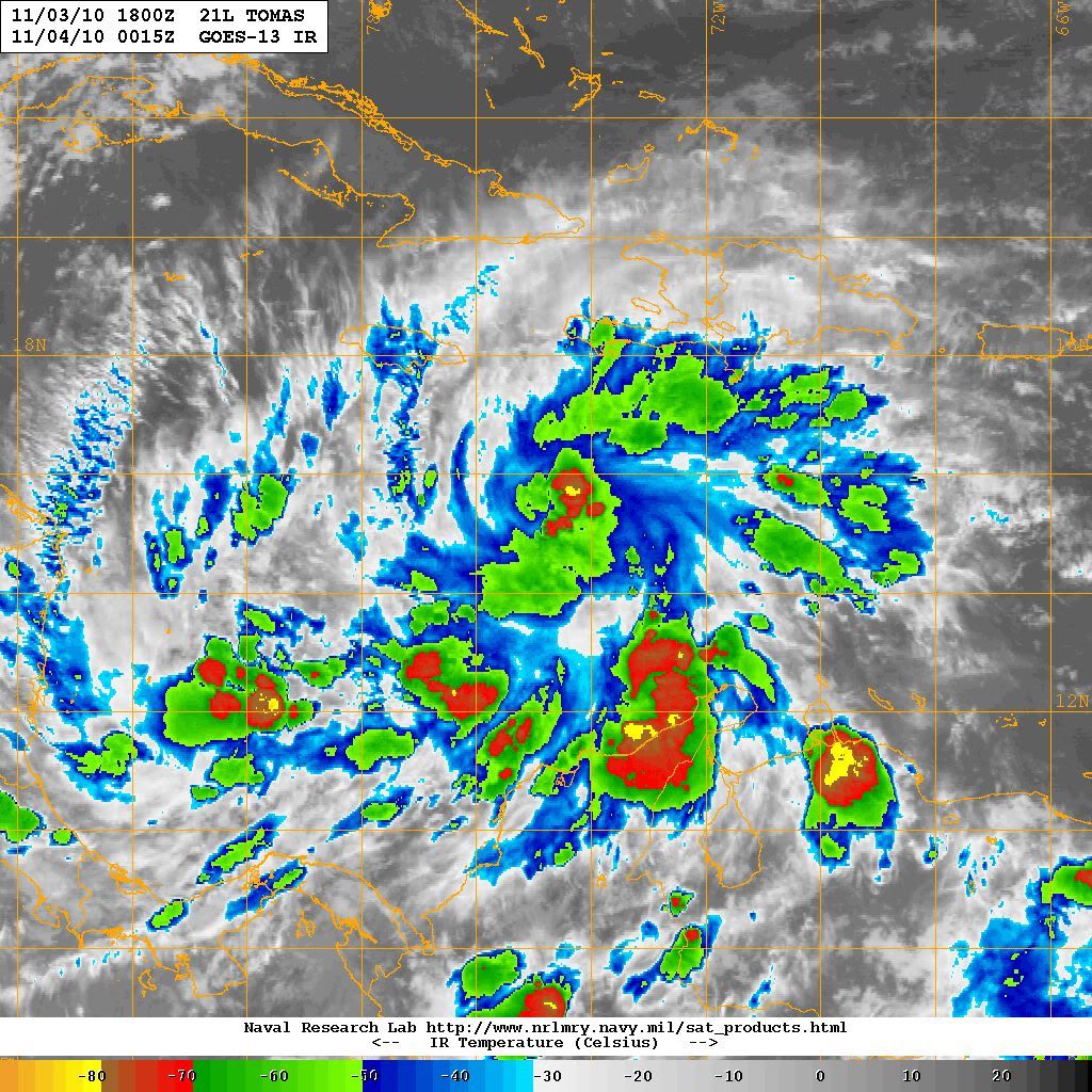
Tomas is looking a lot better organized than this morning, banding is present, outflow is well established and the circulation is far more evident, even if it does not ragain hurricane strength the rains will be dangerous not only for Haiti but for the Dominican Republic as well.
0 likes


-
cycloneye

- Admin

- Posts: 149703
- Age: 69
- Joined: Thu Oct 10, 2002 10:54 am
- Location: San Juan, Puerto Rico
Re: ATL : TOMAS - Tropical Storm - Discussion
Second decoded VDM of current mission.
Product: Air Force Vortex Message (URNT12 KNHC)
Transmitted: 3rd day of the month at 21:47Z
Aircraft: Air Force Aircraft (Last 3 digits of the tail number are 301)
Storm Number & Year: 21L in 2010
Storm Name: Tomas (flight in the North Atlantic basin)
Mission Number: 11
Observation Number: 15
A. Time of Center Fix: 3rd day of the month at 21:30:20Z
B. Center Fix Coordinates: 14°18'N 75°18'W (14.3N 75.3W) (View map)
B. Center Fix Location: 274 miles (441 km) to the SSE (159°) from Kingston, Jamaica.
C. Minimum Height at Standard Level: Not Available
D. Estimated (by SFMR or visually) Maximum Surface Wind: 43kts (~ 49.5mph)
E. Location of the Estimated Maximum Surface Wind: 80 nautical miles (92 statute miles) to the NE (50°) of center fix
F. Maximum Flight Level Wind Inbound: From 149° at 25kts (From the SSE at ~ 28.8mph)
G. Location of Maximum Flight Level Wind Inbound: 85 nautical miles (98 statute miles) to the NE (50°) of center fix
H. Minimum Sea Level Pressure: 1003mb (29.62 inHg) - Extrapolated
I. Maximum Flight Level Temp & Pressure Altitude Outside Eye: 20°C (68°F) at a pressure alt. of 337m (1,106ft)
J. Maximum Flight Level Temp & Pressure Altitude Inside Eye: 22°C (72°F) at a pressure alt. of 334m (1,096ft)
K. Dewpoint Temp & Sea Surface Temp (collected at same location as temp inside eye): Not Available
L. Eye Character: Not Available
M. Eye Shape: Not Available
N. Fix Determined By: Penetration, Wind and Pressure
N. Fix Level: 1,500 feet
O. Navigation Fix Accuracy: 0.02 nautical miles
O. Meteorological Accuracy: 10 nautical miles
Remarks Section:
Maximum Flight Level Wind: 36kts (~ 41.4mph) in the southeast quadrant at 20:16:20Z
Sea Level Pressure Extrapolation From: Below 1,500 feet
Displacement of Sfc. Center From Flt. Lvl. Center: Surface center is 14 nautical miles (16 statute miles) to the E (85°) from the flight level center
Maximum Flight Level Temp: 24°C (75°F) which was observed 13 nautical miles (15 statute miles) to the E (87°) from the flight level center
0 likes
Visit the Caribbean-Central America Weather Thread where you can find at first post web cams,radars
and observations from Caribbean basin members Click Here
and observations from Caribbean basin members Click Here

-
SouthDadeFish

- Professional-Met

- Posts: 2836
- Joined: Thu Sep 23, 2010 2:54 pm
- Location: Miami, FL
- Contact:
-
TheDreamTraveler

- Category 2

- Posts: 645
- Joined: Sun Aug 22, 2010 3:10 am
- Location: PA
Re: ATL : TOMAS - Tropical Storm - Discussion
Tomas is really starting to develop that look. I can't see why this doesn't attain at least minimal hurricane strength by the time it reaches Haiti.
0 likes
-
wxman57

- Moderator-Pro Met

- Posts: 23175
- Age: 68
- Joined: Sat Jun 21, 2003 8:06 pm
- Location: Houston, TX (southwest)
Re: ATL : TOMAS - Tropical Storm - Discussion
Recon is still finding another center south and west of the 21Z position near 14.3N/75.5W. I think the main center is farther north and east, though. This should slow down strengthening tonight.
0 likes
-
cycloneye
- Admin
- Posts: 149703
- Age: 69
- Joined: Thu Oct 10, 2002 10:54 am
- Location: San Juan, Puerto Rico
Re: ATL : TOMAS - Tropical Storm - Discussion
Decoded third VDM from Air Force plane.
Product: Air Force Vortex Message (URNT12 KNHC)
Transmitted: 3rd day of the month at 22:38Z
Aircraft: Air Force Aircraft (Last 3 digits of the tail number are 301)
Storm Number & Year: 21L in 2010
Storm Name: Tomas (flight in the North Atlantic basin)
Mission Number: 11
Observation Number: 18
A. Time of Center Fix: 3rd day of the month at 22:22:30Z
B. Center Fix Coordinates: 14°16'N 75°30'W (14.2667N 75.5W) (View map)
B. Center Fix Location: 272 miles (437 km) to the SSE (162°) from Kingston, Jamaica.
C. Minimum Height at Standard Level: Not Available
D. Estimated (by SFMR or visually) Maximum Surface Wind: 31kts (~ 35.7mph)
E. Location of the Estimated Maximum Surface Wind: 52 nautical miles (60 statute miles) to the SE (131°) of center fix
F. Maximum Flight Level Wind Inbound: From 240° at 17kts (From the WSW at ~ 19.6mph)
G. Location of Maximum Flight Level Wind Inbound: 49 nautical miles (56 statute miles) to the SE (131°) of center fix
H. Minimum Sea Level Pressure: 1003mb (29.62 inHg) - Extrapolated
I. Maximum Flight Level Temp & Pressure Altitude Outside Eye: 22°C (72°F) at a pressure alt. of 360m (1,181ft)
J. Maximum Flight Level Temp & Pressure Altitude Inside Eye: 24°C (75°F) at a pressure alt. of 362m (1,188ft)
K. Dewpoint Temp & Sea Surface Temp (collected at same location as temp inside eye): Not Available
L. Eye Character: Not Available
M. Eye Shape: Not Available
N. Fix Determined By: Penetration and Wind
N. Fix Level: 1,500 feet
O. Navigation Fix Accuracy: 0.02 nautical miles
O. Meteorological Accuracy: 5 nautical miles
Remarks Section:
Maximum Flight Level Wind: 31kts (~ 35.7mph) in the east quadrant at 20:47:20Z
Sea Level Pressure Extrapolation From: Below 1,500 feet
0 likes
Visit the Caribbean-Central America Weather Thread where you can find at first post web cams,radars
and observations from Caribbean basin members Click Here
and observations from Caribbean basin members Click Here
-
SouthDadeFish
- Professional-Met
- Posts: 2836
- Joined: Thu Sep 23, 2010 2:54 pm
- Location: Miami, FL
- Contact:
-
Florida1118
Re: ATL : TOMAS - Tropical Storm - Discussion
Looks like it did before they officially upgraded it
0 likes
-
Aquawind

- Category 5

- Posts: 6714
- Age: 62
- Joined: Mon Jun 16, 2003 10:41 pm
- Location: Salisbury, NC
- Contact:
Re: ATL : TOMAS - Tropical Storm - Discussion

Around 15.2N 74.5..
Current loop shows the center of the roation is a tad wsw of the current cell near the center.. http://www.ssd.noaa.gov/goes/flt/t2/flash-avn.html
0 likes

-
srainhoutx

- S2K Supporter

- Posts: 6919
- Age: 68
- Joined: Sun Jan 14, 2007 11:34 am
- Location: Haywood County, NC
- Contact:
Re: ATL : TOMAS - Tropical Storm - Discussion
I believe we have a consolidation for a dominate center tonight...
Personal Forecast Disclaimer:
The posts in this forum are NOT official forecast and should not be used as such. They are just the opinion of the poster and may or may not be backed by sound meteorological data. They are NOT endorsed by any professional institution or storm2k.org. For official information, please refer to the NHC and NWS products.
0 likes
Carla/Alicia/Jerry(In The Eye)/Michelle/Charley/Ivan/Dennis/Katrina/Rita/Wilma/Ike/Harvey
Member: National Weather Association
Wx Infinity Forums
http://wxinfinity.com/index.php
Facebook.com/WeatherInfinity
Twitter @WeatherInfinity
Member: National Weather Association
Wx Infinity Forums
http://wxinfinity.com/index.php
Facebook.com/WeatherInfinity
Twitter @WeatherInfinity
Who is online
Users browsing this forum: No registered users and 203 guests