Decoded VDM
Product: NOAA Vortex Message (URNT12 KWBC)
Transmitted: 6th day of the month at 23:04Z
Aircraft: Lockheed WP-3D Orion (Reg. Num. N42RF)
Storm Number & Year: 21L in 2010
Storm Name: Tomas (flight in the North Atlantic basin)
Mission Number: 22
Observation Number: 10
A. Time of Center Fix: 6th day of the month at 22:36Z
B. Center Fix Coordinates: 24°47'N 69°49'W (24.7833N 69.8167W) (View map)
B. Center Fix Location: 472 miles (760 km) to the E (92°) from Nassau, Bahamas.
C. Minimum Height at Standard Level: 2,999m (9,839ft) at 700mb
D. Estimated (by SFMR or visually) Maximum Surface Wind: 46kts (~ 52.9mph)
E. Location of the Estimated Maximum Surface Wind: 16 nautical miles (18 statute miles) to the WSW (251°) of center fix
F. Maximum Flight Level Wind Inbound: From 8° at 46kts (From the N at ~ 52.9mph)
G. Location of Maximum Flight Level Wind Inbound: 20 nautical miles (23 statute miles) to the WSW (254°) of center fix
H. Minimum Sea Level Pressure: 989mb (29.21 inHg)
I. Maximum Flight Level Temp & Pressure Altitude Outside Eye: 11°C (52°F) at a pressure alt. of 3,066m (10,059ft)
J. Maximum Flight Level Temp & Pressure Altitude Inside Eye: 27°C (81°F) at a pressure alt. of 3,057m (10,030ft)
K. Dewpoint Temp (collected at same location as temp inside eye): 8°C (46°F)
K. Sea Surface Temp (collected at same location as temp inside eye): Not Available
L. Eye Character: Open in the southwest
M. Eye Shape & Diameter: Circular with a diameter of 25 nautical miles (29 statute miles)
N. Fix Determined By: Penetration, Radar, Wind, Pressure and Temperature
N. Fix Level: 700mb
O. Navigation Fix Accuracy: 1 nautical mile
O. Meteorological Accuracy: 1 nautical mile
Remarks Section - Remarks That Were Decoded...
Maximum Flight Level Wind: 46kts (~ 52.9mph) in the southwest quadrant at 22:31Z
Maximum Flight Level Wind Outbound: 79kts (~ 90.9mph) in the southeast quadrant at 22:41Z
Remarks Section - Additional Remarks...
MAX OUTBOUND SURFACE WIND ESTIMATE 64KT SE QUAD 2240Z
SONDE SPLASH WITH WIND 080 DEG 33KT
ATL : EX TOMAS - Discussion
Moderator: S2k Moderators
-
cycloneye

- Admin

- Posts: 149262
- Age: 69
- Joined: Thu Oct 10, 2002 10:54 am
- Location: San Juan, Puerto Rico
Re: ATL : TOMAS - Hurricane - Discussion
0 likes
Visit the Caribbean-Central America Weather Thread where you can find at first post web cams,radars
and observations from Caribbean basin members Click Here
and observations from Caribbean basin members Click Here
-
cycloneye
- Admin
- Posts: 149262
- Age: 69
- Joined: Thu Oct 10, 2002 10:54 am
- Location: San Juan, Puerto Rico
Re: ATL : TOMAS - Hurricane - Discussion
Tomas for sure will be a very interesting system that will be studied a lot with the many twists and turns on intensity that it has endured from the start to when it finnally dissipates.
0 likes
Visit the Caribbean-Central America Weather Thread where you can find at first post web cams,radars
and observations from Caribbean basin members Click Here
and observations from Caribbean basin members Click Here
-
srainhoutx

- S2K Supporter

- Posts: 6919
- Age: 68
- Joined: Sun Jan 14, 2007 11:34 am
- Location: Haywood County, NC
- Contact:
Re: ATL : TOMAS - Hurricane - Discussion
Product: NOAA Vortex Message (URNT12 KWBC)
Transmitted: 6th day of the month at 23:59Z
Aircraft: Lockheed WP-3D Orion (Reg. Num. N42RF)
Storm Number & Year: 21L in 2010
Storm Name: Tomas (flight in the North Atlantic basin)
Mission Number: 22
Observation Number: 15
A. Time of Center Fix: 6th day of the month at 23:41Z
B. Center Fix Coordinates: 24°54'N 69°45'W (24.9N 69.75W)
B. Center Fix Location: 476 miles (766 km) to the E (91°) from Nassau, Bahamas.
C. Minimum Height at Standard Level: 2,998m (9,836ft) at 700mb
D. Estimated (by SFMR or visually) Maximum Surface Wind: 63kts (~ 72.5mph)
E. Location of the Estimated Maximum Surface Wind: 13 nautical miles (15 statute miles) to the NE (39°) of center fix
F. Maximum Flight Level Wind Inbound: From 130° at 70kts (From the SE at ~ 80.6mph)
G. Location of Maximum Flight Level Wind Inbound: 19 nautical miles (22 statute miles) to the NE (39°) of center fix
H. Minimum Sea Level Pressure: 987mb (29.15 inHg)
I. Maximum Flight Level Temp & Pressure Altitude Outside Eye: 10°C (50°F) at a pressure alt. of 3,072m (10,079ft)
J. Maximum Flight Level Temp & Pressure Altitude Inside Eye: 15°C (59°F) at a pressure alt. of 3,055m (10,023ft)
K. Dewpoint Temp (collected at same location as temp inside eye): 12°C (54°F)
K. Sea Surface Temp (collected at same location as temp inside eye): Not Available
L. Eye Character: Poorly Defined
M. Eye Shape: Not Available
N. Fix Determined By: Penetration, Radar, Wind, Pressure and Temperature
N. Fix Level: 700mb
O. Navigation Fix Accuracy: 1 nautical mile
O. Meteorological Accuracy: 1 nautical mile
Remarks Section - Remarks That Were Decoded...
Maximum Flight Level Wind: 70kts (~ 80.6mph) in the northeast quadrant at 23:38Z
Remarks Section - Additional Remarks...
SONDE LAUNCHED AT 24 DEG 50 MIN N 69 DEG 46 MIN W
0 likes
Carla/Alicia/Jerry(In The Eye)/Michelle/Charley/Ivan/Dennis/Katrina/Rita/Wilma/Ike/Harvey
Member: National Weather Association
Wx Infinity Forums
http://wxinfinity.com/index.php
Facebook.com/WeatherInfinity
Twitter @WeatherInfinity
Member: National Weather Association
Wx Infinity Forums
http://wxinfinity.com/index.php
Facebook.com/WeatherInfinity
Twitter @WeatherInfinity
-
cycloneye
- Admin
- Posts: 149262
- Age: 69
- Joined: Thu Oct 10, 2002 10:54 am
- Location: San Juan, Puerto Rico
Re: ATL : TOMAS - Hurricane - Discussion
Best Track increased the intensity to 65kts at the 18z timeframe this afternoon when it was at 55kts.In other words,it was a hurricane by the 5 PM advisory,but NHC went with 55 kts.
AL, 21, 2010110618, , BEST, 0, 238N, 703W, 65, 988, HU
ftp://ftp.tpc.ncep.noaa.gov/atcf/tcweb/ ... 010.invest
AL, 21, 2010110618, , BEST, 0, 238N, 703W, 65, 988, HU
ftp://ftp.tpc.ncep.noaa.gov/atcf/tcweb/ ... 010.invest
0 likes
Visit the Caribbean-Central America Weather Thread where you can find at first post web cams,radars
and observations from Caribbean basin members Click Here
and observations from Caribbean basin members Click Here
-
HurricaneBelle

- S2K Supporter
- Posts: 1209
- Joined: Sun Aug 27, 2006 6:12 pm
- Location: Clearwater, FL
Re: ATL : TOMAS - Hurricane - Discussion
cycloneye wrote:Best Track increased the intensity to 65kts at the 18z timeframe this afternoon when it was at 55kts.In other words,it was a hurricane by the 5 PM advisory,but NHC went with 55 kts.
AL, 21, 2010110618, , BEST, 0, 238N, 703W, 65, 988, HU
ftp://ftp.tpc.ncep.noaa.gov/atcf/tcweb/ ... 010.invest
Looked more like a hurricane then than it does now.
0 likes


-
brunota2003

- S2K Supporter
- Posts: 9476
- Age: 35
- Joined: Sat Jul 30, 2005 9:56 pm
- Location: Stanton, KY...formerly Havelock, NC
- Contact:

-
cycloneye
- Admin
- Posts: 149262
- Age: 69
- Joined: Thu Oct 10, 2002 10:54 am
- Location: San Juan, Puerto Rico
Re:
brunota2003 wrote:Did recon miss the center?
No VDM,so yes,they missed it.
0 likes
Visit the Caribbean-Central America Weather Thread where you can find at first post web cams,radars
and observations from Caribbean basin members Click Here
and observations from Caribbean basin members Click Here

Re: ATL : TOMAS - Hurricane - Discussion
Venting up the front and just enough SST's kept Tomas hurricane (I guess).
0 likes
-
ozonepete
- Professional-Met

- Posts: 4743
- Joined: Mon Sep 07, 2009 3:23 pm
- Location: From Ozone Park, NYC / Now in Brooklyn, NY
Re: ATL : TOMAS - Hurricane - Discussion
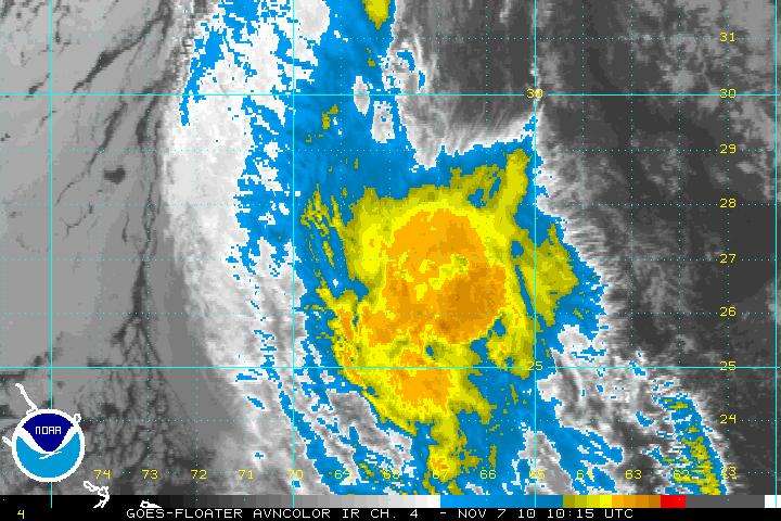
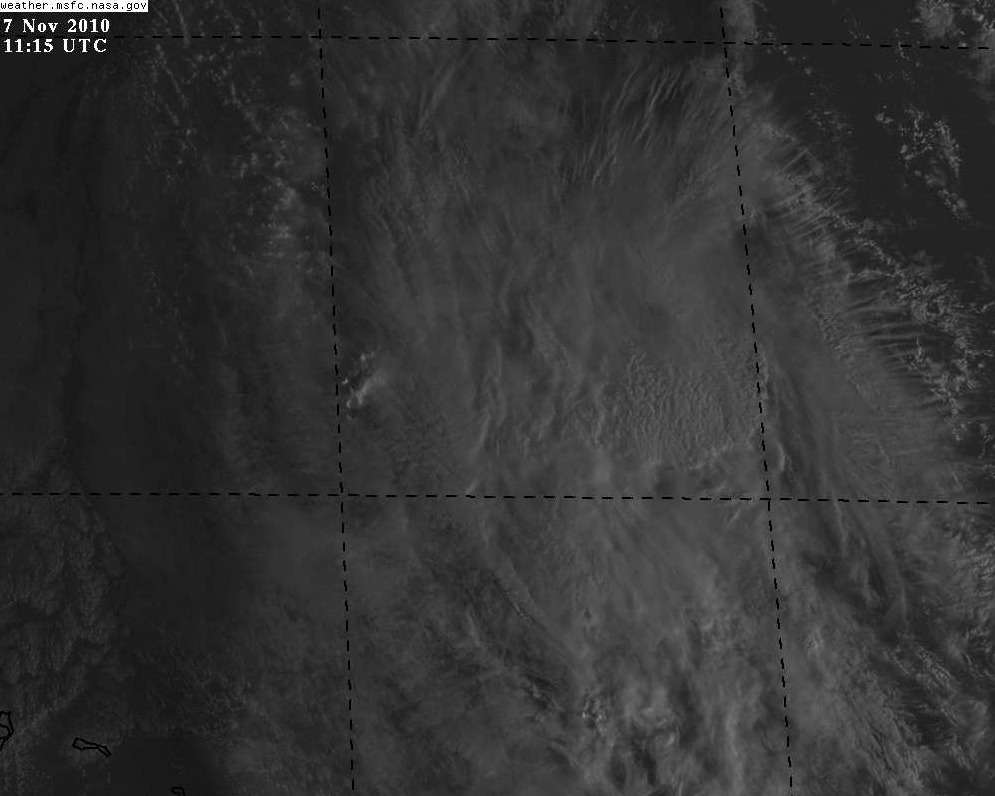
I'm pretty surprised it's still tropical, but that's the fun of trying to figure these storms out.
From the 11PM NHC storm discussion:
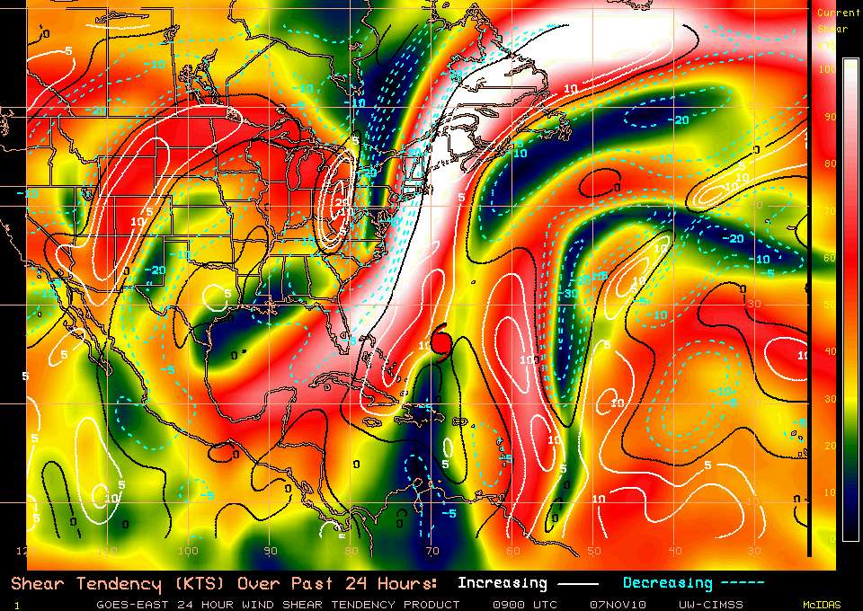
IT IS WORTH NOTING THAT THE UKMET MAINTAINS TOMAS AS A DEEPER CYCLONE AND TAKES IT FARTHER NORTHWARD BEFORE MERGING IT WITH A FRONTAL ZONE. HOWEVER... THIS SCENARIO SEEMS UNLIKELY GIVEN THAT TOMAS SHOULD HAVE DIFFICULTY REMAINING A DEEP CYCLONE DUE TO THE SHEAR AND UNFAVORABLE THERMODYNAMIC CONDITIONS.
I don't know, I think the UKMET may have it right. It still looks like Tomas could ride NNE up that front. Many huricanes have done this. To me, it's harder to see the official track with a sharp turn to the east occurring momentarily; Tomas is certainly not showing much sign of weakening right now. The track forecast is always more fascinating when the storm's future track is heavily tied to its strength.
From the 11PM NHC storm discussion:
IT IS WORTH NOTING THAT THE UKMET MAINTAINS TOMAS AS A DEEPER CYCLONE AND TAKES IT FARTHER NORTHWARD BEFORE MERGING IT WITH A FRONTAL ZONE. HOWEVER... THIS SCENARIO SEEMS UNLIKELY GIVEN THAT TOMAS SHOULD HAVE DIFFICULTY REMAINING A DEEP CYCLONE DUE TO THE SHEAR AND UNFAVORABLE THERMODYNAMIC CONDITIONS.
I don't know, I think the UKMET may have it right. It still looks like Tomas could ride NNE up that front. Many huricanes have done this. To me, it's harder to see the official track with a sharp turn to the east occurring momentarily; Tomas is certainly not showing much sign of weakening right now. The track forecast is always more fascinating when the storm's future track is heavily tied to its strength.
0 likes
-
tolakram
- Admin
- Posts: 20178
- Age: 62
- Joined: Sun Aug 27, 2006 8:23 pm
- Location: Florence, KY (name is Mark)
Re: ATL : TOMAS - Hurricane - Discussion
Out of room.
0 likes
M a r k
- - - - -
Join us in chat: Storm2K Chatroom Invite. Android and IOS apps also available.
The posts in this forum are NOT official forecasts and should not be used as such. Posts are NOT endorsed by any professional institution or STORM2K.org. For official information and forecasts, please refer to NHC and NWS products.
-
tolakram
- Admin
- Posts: 20178
- Age: 62
- Joined: Sun Aug 27, 2006 8:23 pm
- Location: Florence, KY (name is Mark)
Re: ATL : TOMAS - Hurricane - Discussion
Where is Tomas?
0 likes
M a r k
- - - - -
Join us in chat: Storm2K Chatroom Invite. Android and IOS apps also available.
The posts in this forum are NOT official forecasts and should not be used as such. Posts are NOT endorsed by any professional institution or STORM2K.org. For official information and forecasts, please refer to NHC and NWS products.
- - - - -
Join us in chat: Storm2K Chatroom Invite. Android and IOS apps also available.
The posts in this forum are NOT official forecasts and should not be used as such. Posts are NOT endorsed by any professional institution or STORM2K.org. For official information and forecasts, please refer to NHC and NWS products.


-
Gustywind

- Category 5

- Posts: 12334
- Joined: Mon Sep 03, 2007 7:29 am
- Location: Baie-Mahault, GUADELOUPE
Hurricane Tomas revives the risk of outbreak of cholera in Haiti REUTERS 07.11.2010
 http://www.microsofttranslator.com/bv.a ... 100636.php
Photo taken on November 6, 2010 / Eduardo Munoz
by Matthew Bigg
PORT - AU-PRINCE (Reuters) - the threat from Hurricane Tomas remote Haiti Saturday but the passage of depression that has flooded several coastal cities concern a resumption of the cholera epidemic, say Government and humanitarian organizations.
The country struck by an earthquake which is 250,000 deaths and left 1.3 million homeless in Port - au Prince remains extremely vulnerable because of poor living and sanitation conditions in overcrowded makeshift camps of the capital.
Humanitarian organizations concerned in particular of a resurgence of the cholera epidemic appeared two weeks ago and gave 500 deaths and more than 7,000 sick.
"We expect really a surge of infections due to flooding and poor sanitary conditions in many areas", says Christian Lindmeier, Haiti, the world Organization of the health spokesperson.
"Cholera is a disease which is mediated by the water and any increase in the level of the water means an increase in the level of the disease," he explains.
The passage of Tomas has forced thousands of people to leave their homes and soaked the camps of refugees in Port - au Prince. Eight people are dead and 10,000 fled floods.
This depression was however not violence from those who had beaten island Caribbean in 2004 and 2008, killing thousands of people.
NEW CALL FOR INTERNATIONAL ASSISTANCE
UN Haiti officials believe that the country had the chance to be unaffected by a more violent than Tomas hurricane. "We have avoided the worst", says Elisabeth Diaz, spokesman for the Office of the United Nations for the coordination of Humanitarian Affairs.
Hurricane away and transformed into a tropical storm to resume the force that he earned the ocean Atlantic Saturday night.
The cholera epidemic that affects five provinces of Haiti seems to continue to expand. According to statistics provided by the Ministry of health, disease killed 501 4 November against 442 according to a count conducted the day before.
Easily treatable rehydration patients, disease requires significant supplies of food and drinking water in areas affected by the floods.
The affected situation in Leogane, located west of Port - au Prince and particularly affected by the earthquake of January 12, concerned about humanitarian organizations.
Floods that have affected 35,000 people have transformed the streets of this city in rivers, carrying tents and destroying property, according to the British charity Save the Children.
In this city, thousands of children are threatened by the epidemic of cholera, but also by malaria and dysentery.
The Government of Haiti and the United Nations launched Friday appealed gifts, 19 million of dollars necessary to cover the most urgent needs.
Nigel Fisher, Coordinator of the UN assistance, said Tomas hurricane damaged crops coffee and bananas and called on the international community to take the action necessary reconstruction efforts after the earthquake of January.
"This hurricane was diverted our attention but we must refocus us." "Emphasis must absolutely be placed on the reconstruction", he said.
Tomas also disrupted preparations for the presidential and legislative elections scheduled on 28 November even if election officials refused to postpone returning to another date.
Pierre Sérisier French service
0 likes

Looks like Tomas is just about finished now, hopefully that'll be the end of the 2010 season, was certainbly one of the more 'interesting' track/strength wise and possibly threatening systems to watch in the last few years.
0 likes
Personal Forecast Disclaimer:
The posts in this forum are NOT official forecast and should not be used as such. They are just the opinion of the poster and may or may not be backed by sound meteorological data. They are NOT endorsed by any professional institution or storm2k.org. For official information, please refer to the NHC and NWS products
The posts in this forum are NOT official forecast and should not be used as such. They are just the opinion of the poster and may or may not be backed by sound meteorological data. They are NOT endorsed by any professional institution or storm2k.org. For official information, please refer to the NHC and NWS products
-
cycloneye
- Admin
- Posts: 149262
- Age: 69
- Joined: Thu Oct 10, 2002 10:54 am
- Location: San Juan, Puerto Rico
Re: ATL : TOMAS - Tropical Storm - Discussion
The last advisory has been written but this system was a very interesting one to follow,starting where it formed and more from a Cape Verde wave on late October. The post season report as I have said before will be very interesting.
This is the wave emerging West Africa on October 23rd that later gave birth to Tomas.

This is the wave emerging West Africa on October 23rd that later gave birth to Tomas.
0 likes
Visit the Caribbean-Central America Weather Thread where you can find at first post web cams,radars
and observations from Caribbean basin members Click Here
and observations from Caribbean basin members Click Here

Who is online
Users browsing this forum: Google [Bot] and 70 guests