Winter 2010-11 for the Southern Plains
Moderator: S2k Moderators
Forum rules
 The posts in this forum are NOT official forecast and should not be used as such. They are just the opinion of the poster and may or may not be backed by sound meteorological data. They are NOT endorsed by any professional institution or STORM2K.

The posts in this forum are NOT official forecast and should not be used as such. They are just the opinion of the poster and may or may not be backed by sound meteorological data. They are NOT endorsed by any professional institution or STORM2K.
-
TwisterFanatic

- Category 5

- Posts: 1041
- Joined: Mon Jun 28, 2010 12:43 pm
- Location: Sallisaw, Oklahoma
Yea, i was just about to mention something on the consistency of the models about colder weather, extremeweatherguy. It will be interesting to watch, nonetheless.
0 likes
Personal Forecast Disclaimer:
The posts in this forum are NOT official forecast and should not be used as such. They are just the opinion of the poster and may or may not be backed by sound meteorological data. They are NOT endorsed by any professional institution or storm2k.org. For official information, please refer to the NHC and NWS products.
The posts in this forum are NOT official forecast and should not be used as such. They are just the opinion of the poster and may or may not be backed by sound meteorological data. They are NOT endorsed by any professional institution or storm2k.org. For official information, please refer to the NHC and NWS products.
-
TwisterFanatic
- Category 5
- Posts: 1041
- Joined: Mon Jun 28, 2010 12:43 pm
- Location: Sallisaw, Oklahoma
Looks as if the GFS is still wanting to show some light wintry precip falling in the Southern Plains in about 9-10 days.
0 likes
Personal Forecast Disclaimer:
The posts in this forum are NOT official forecast and should not be used as such. They are just the opinion of the poster and may or may not be backed by sound meteorological data. They are NOT endorsed by any professional institution or storm2k.org. For official information, please refer to the NHC and NWS products.
The posts in this forum are NOT official forecast and should not be used as such. They are just the opinion of the poster and may or may not be backed by sound meteorological data. They are NOT endorsed by any professional institution or storm2k.org. For official information, please refer to the NHC and NWS products.
-
Extremeweatherguy

- Category 5
- Posts: 11095
- Joined: Mon Oct 10, 2005 8:13 pm
- Location: Florida
Re: Winter 2010-11 for the Southern Plains
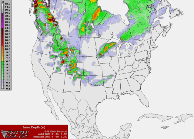
Yes, recent runs continue to look cold and perhaps wintry in the extended. In fact, tonight's 00z GFS run even brings a taste of winter to Oklahoma in as little as 6 days! Check out the 144 hour snowfall map showing accumulating snow in north-central OK next Friday:TwisterFanatic wrote:Looks as if the GFS is still wanting to show some light wintry precip falling in the Southern Plains in about 9-10 days.
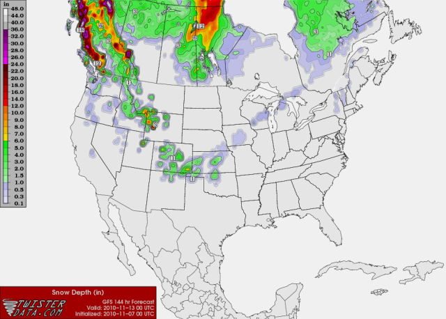
This is the first run to show such a scenario though, so let's wait and see if there is more consistency over the next couple of days before getting too excited about this possibility.
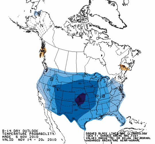
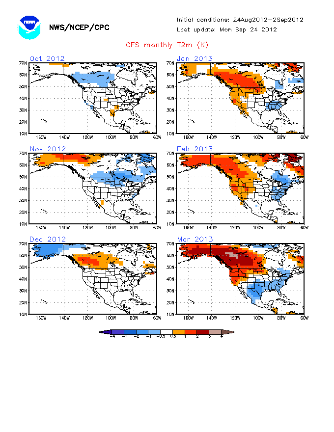
Beyond next week's possible winter tease, things start to look even more interesting by mid to late November. We are still too far out to get our hopes up about any particular storm or airmass, but the overall trend in the models continues to be towards colder and perhaps stormier during the period leading up to Thanksgiving. The latest day 8-14 temperature outlook from the CPC highlights this idea well, showing high probabilities of below normal temperatures across our region between Nov. 14th and 20th:
0 likes
-
TwisterFanatic
- Category 5
- Posts: 1041
- Joined: Mon Jun 28, 2010 12:43 pm
- Location: Sallisaw, Oklahoma
Good info, thanks for the temp map. 
0 likes
Personal Forecast Disclaimer:
The posts in this forum are NOT official forecast and should not be used as such. They are just the opinion of the poster and may or may not be backed by sound meteorological data. They are NOT endorsed by any professional institution or storm2k.org. For official information, please refer to the NHC and NWS products.
The posts in this forum are NOT official forecast and should not be used as such. They are just the opinion of the poster and may or may not be backed by sound meteorological data. They are NOT endorsed by any professional institution or storm2k.org. For official information, please refer to the NHC and NWS products.
-
Extremeweatherguy
- Category 5
- Posts: 11095
- Joined: Mon Oct 10, 2005 8:13 pm
- Location: Florida
The 12z GFS is running now, and it still looks to show wrap around precipitation behind the low on Friday/Saturday. However, the upper levels do not look cold enough for snow/sleet in this run (except for the OK panhandle), so it would probably just be a chilly rainfall. If the model is slightly too warm with the upper levels though, then that would change things. It looks like a close call overall, though I am personally leaning towards the rain option being more likely with this first system.
The extended still looks good though for those wanting a taste of winter, with a much colder and stormier pattern continuing to be depicted by the 12z GFS as we head towards Thanksgiving.
The extended still looks good though for those wanting a taste of winter, with a much colder and stormier pattern continuing to be depicted by the 12z GFS as we head towards Thanksgiving.
Last edited by Extremeweatherguy on Sun Nov 07, 2010 12:13 pm, edited 3 times in total.
0 likes
-
srainhoutx

- S2K Supporter

- Posts: 6919
- Age: 68
- Joined: Sun Jan 14, 2007 11:34 am
- Location: Haywood County, NC
- Contact:
Re: Winter 2010-11 for the Southern Plains
Interesting to see so many coastal lows developing in the longer range in GFS world. Certainly a pattern worth noting.
0 likes
Carla/Alicia/Jerry(In The Eye)/Michelle/Charley/Ivan/Dennis/Katrina/Rita/Wilma/Ike/Harvey
Member: National Weather Association
Wx Infinity Forums
http://wxinfinity.com/index.php
Facebook.com/WeatherInfinity
Twitter @WeatherInfinity
Member: National Weather Association
Wx Infinity Forums
http://wxinfinity.com/index.php
Facebook.com/WeatherInfinity
Twitter @WeatherInfinity

If I didn't know any better just by the looks of the models I'd be thinking a Nino was raging in the pacific somewhere in the far away distance of space and time...seriously, what an odd pattern for a Nina if this were to pan out as the GFS thinks.
I'm interested to see how well the GFS performs this winter with the summer upgrades. It's been more consistently conservative and somewhat Euro-like so far at least for the nearer terms.
I'm interested to see how well the GFS performs this winter with the summer upgrades. It's been more consistently conservative and somewhat Euro-like so far at least for the nearer terms.
0 likes
The above post and any post by Ntxw is NOT an official forecast and should not be used as such. It is just the opinion of the poster and may or may not be backed by sound meteorological data. It is NOT endorsed by any professional institution including Storm2k. For official information, please refer to NWS products.
Help support Storm2K!
-
Extremeweatherguy
- Category 5
- Posts: 11095
- Joined: Mon Oct 10, 2005 8:13 pm
- Location: Florida
The 00z GFS continues to look chilly tonight.
This Friday it is showing temperatures in OKC dropping from the upper 50s at 6am to the upper 40s by 12pm. At the same time widespread rain is also depicted across the region, with breezy north winds developing. By 6pm the GFS has the temperature in OKC sitting at 46F with gradually clearing skies and still breezy north winds. If this scenario is correct, then it will be the first day this season to really feel somewhat "winter-like" in central Oklahoma.
By late Sunday into early next week, the GFS then looks even colder across the region. On Monday it is showing scattered clouds and a few showers across the area (wintry mix across northern OK?), with temperatures struggling to even reach 50F for a high temperature in OKC. By late in the day, 850mb temperatures over OKC fall below 0C and thicknesses drop below 540 with surface temperatures falling into the 30s. If any lingering showers are still hanging around central Oklahoma (which the GFS is currently not showing), then some mixing would be possible. Being 6 days out though, we still have plenty of time to watch this scenario develop one way or the other.
The longer range is where things continue to look even more interesting though. As always, this timeframe is subject to large changes, but as of now the GFS is showing several 1050mb+ high pressure areas building in Canada as we push towards Thanksgiving. These signals from the model lead me to believe that a significant arctic outbreak could be in store by the end of the month. We will have to watch this possibility closely..
0 likes
-
TwisterFanatic
- Category 5
- Posts: 1041
- Joined: Mon Jun 28, 2010 12:43 pm
- Location: Sallisaw, Oklahoma
Re: Winter 2010-11 for the Southern Plains
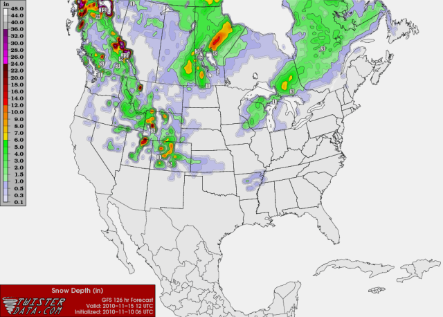
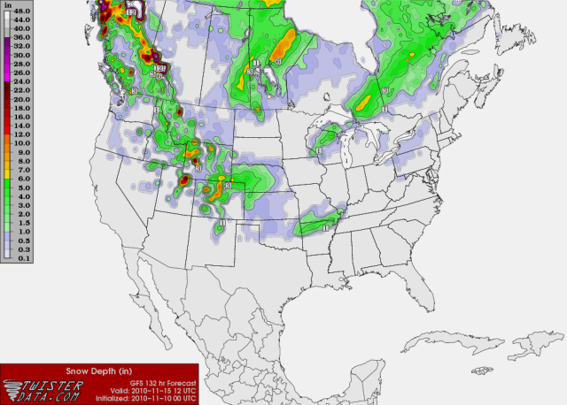
The Snow Cover map at 132 Hours is rather interesting.. I have noticed the GFS sorta trending at some light winter precip in this timeframe. Will be interesting to see if the GFS keeps seeing this.

0 likes
Personal Forecast Disclaimer:
The posts in this forum are NOT official forecast and should not be used as such. They are just the opinion of the poster and may or may not be backed by sound meteorological data. They are NOT endorsed by any professional institution or storm2k.org. For official information, please refer to the NHC and NWS products.
The posts in this forum are NOT official forecast and should not be used as such. They are just the opinion of the poster and may or may not be backed by sound meteorological data. They are NOT endorsed by any professional institution or storm2k.org. For official information, please refer to the NHC and NWS products.
-
Extremeweatherguy
- Category 5
- Posts: 11095
- Joined: Mon Oct 10, 2005 8:13 pm
- Location: Florida
The arctic airmasses the 6z GFS is showing in the longer range would be quite impressive by November standards if they came to pass. In fact, they would even be cold by mid-January standards! Starting the weekend before Thanksgiving (next weekend) the 6z run puts us in the deep chill, showing a large winter storm to kick things off, followed by several back-to-back sub-40F afternoons and sub-25F nights in central Oklahoma. In fact, some days it is showing highs below freezing with lows well into the teens! To our north, into the central plains and over towards the mid mississippi valley (I will be in mid Missouri for Thanksgiving) it is showing lows flirting with the 0F mark at times!
While this is still very far out, it shows that there is certainly "potential" for us to deal with very frigid, possibly record-threatening airmasses later in the month. It is not a done deal yet by any means, but with continued model support and the subsequent bullish outlooks by the CPC; the risk definitely appears to be growing.
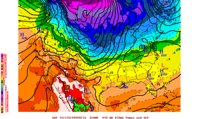
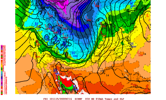
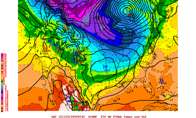
BTW, the 00z ECMWF looks to be on board as well. I do not have access to the data out to 384 hours like the GFS, but at hours 216-240 it seems to be pushing the first arctic airmass into the USA with more very cold air building in Canada; possibly priming itself to drop southward in the following days:
http://i43.photobucket.com/albums/e371/ ... PUS216.gif
http://i43.photobucket.com/albums/e371/ ... PUS240.gif
While this is still very far out, it shows that there is certainly "potential" for us to deal with very frigid, possibly record-threatening airmasses later in the month. It is not a done deal yet by any means, but with continued model support and the subsequent bullish outlooks by the CPC; the risk definitely appears to be growing.
BTW, the 00z ECMWF looks to be on board as well. I do not have access to the data out to 384 hours like the GFS, but at hours 216-240 it seems to be pushing the first arctic airmass into the USA with more very cold air building in Canada; possibly priming itself to drop southward in the following days:
http://i43.photobucket.com/albums/e371/ ... PUS216.gif
http://i43.photobucket.com/albums/e371/ ... PUS240.gif
0 likes
12z GFS comes a bit warmer for the southern sector to thanksgivings (still chilly just not breaking any records). Still has tremendous cold air building in Canada but doesn't quite have the mechanism to unlock it just yet. Lets see if this starts a new trend.
If all this does come to fruition, anyone notice it's not that crazy cold over in Siberia throughout the same period? This would be from our side of the Arctic.
Edit: 12z EC does the same thing, has cold air but keeps it bottled up along the northern tier.
If all this does come to fruition, anyone notice it's not that crazy cold over in Siberia throughout the same period? This would be from our side of the Arctic.
Edit: 12z EC does the same thing, has cold air but keeps it bottled up along the northern tier.
Last edited by Ntxw on Wed Nov 10, 2010 2:28 pm, edited 1 time in total.
0 likes
The above post and any post by Ntxw is NOT an official forecast and should not be used as such. It is just the opinion of the poster and may or may not be backed by sound meteorological data. It is NOT endorsed by any professional institution including Storm2k. For official information, please refer to NWS products.
Help support Storm2K!
Help support Storm2K!
-
dwsqos2
-
Extremeweatherguy
- Category 5
- Posts: 11095
- Joined: Mon Oct 10, 2005 8:13 pm
- Location: Florida
Re: Winter 2010-11 for the Southern Plains
For Oklahomans, we might want to start looking at this upcoming Sunday night into Monday morning a bit more closely. The last several runs of the GFS have been hinting that there might be more than just a few "rain" showers around during that time period. Instead, some of us might be looking at our first "wintry mix" of the season. It doesn't look like that big of a deal right now, but it is definitely worth keeping an eye on..
Below are the snowfall accumulation maps (valid 6am Monday morning) from the last several GFS runs:
18z GFS
http://i43.photobucket.com/albums/e371/ ... URFACE.png
12z GFS
http://i43.photobucket.com/albums/e371/ ... URFACE.png
06z GFS
http://i43.photobucket.com/albums/e371/ ... URFACE.png
00z GFS
http://i43.photobucket.com/albums/e371/ ... URFACE.png
UPDATE (10:13pm): Tonight's latest 00z GFS run now looks slightly warmer at the upper levels Sunday night into Monday, and keeps most of the precipitation to our southeast. Not good for those wanting a little wintry mix. There is still time to watch this though, and the models could always trend the other way tomorrow. We will also have the NAM to look at by the next set of 00z runs, which will be helpful. In the end though, I think we might have to wait until some of that much colder air (possibly) dives south later in the month before we have a chance to see any "significant" winter precipitation threats across OK/TX.
UPDATE #2 (10:35am): The models are looking even worse today. Less upper level cold air, and the precipitation is even further away. This once-possible wintry mix is now looking pretty unlikely.
Last edited by Extremeweatherguy on Thu Nov 11, 2010 11:38 am, edited 1 time in total.
0 likes
-
Extremeweatherguy
- Category 5
- Posts: 11095
- Joined: Mon Oct 10, 2005 8:13 pm
- Location: Florida
-
Portastorm

- Storm2k Moderator

- Posts: 9954
- Age: 63
- Joined: Fri Jul 11, 2003 9:16 am
- Location: Round Rock, TX
- Contact:
Re: Winter 2010-11 for the Southern Plains
IIRC correctly, should that run of the Euro verify, the Arctic air is positioned in just the right spot to pour it into the Southern Plains. The cold air would drop right down the right side of the Rockies into the Kansas-Oklahoma-Texas. Wow, that could be fun!
Southern Plains winter weather fans should get excited because while I think the strength of these Arctic airmasses will be impressive this winter, they'll probably be few and far between.
Southern Plains winter weather fans should get excited because while I think the strength of these Arctic airmasses will be impressive this winter, they'll probably be few and far between.
0 likes
Hmm, I wonder if the models hold the arctic air to the north not sending it down because they are having trouble with how shallow it might be? After all they do have a bad history with shallow arctic air masses.
0 likes
The above post and any post by Ntxw is NOT an official forecast and should not be used as such. It is just the opinion of the poster and may or may not be backed by sound meteorological data. It is NOT endorsed by any professional institution including Storm2k. For official information, please refer to NWS products.
Help support Storm2K!
Help support Storm2K!
-
Portastorm
- Storm2k Moderator
- Posts: 9954
- Age: 63
- Joined: Fri Jul 11, 2003 9:16 am
- Location: Round Rock, TX
- Contact:
Re: Winter 2010-11 for the Southern Plains
Well, they do ... I mean the GFS has been notorious in winters past of missing Arctic outbreaks with shallow profiles. I wonder if this year's "fixes" have done anything to remedy that weakness.
Meanwhile, I see the Veterans Day 12z run of the GFS does what the last few 12z runs have done with the cold air ... keeping it bottled up north. Tonight's 0z run will probably bring down the Mother Lode by Thanksgiving!
Meanwhile, I see the Veterans Day 12z run of the GFS does what the last few 12z runs have done with the cold air ... keeping it bottled up north. Tonight's 0z run will probably bring down the Mother Lode by Thanksgiving!
0 likes
-
srainhoutx
- S2K Supporter
- Posts: 6919
- Age: 68
- Joined: Sun Jan 14, 2007 11:34 am
- Location: Haywood County, NC
- Contact:
Re: Winter 2010-11 for the Southern Plains
The Canadian is onboard depicting a 1054mb Arctic High a bit further W, but at least in the 144 hour time frame, that model is seeing the same pattern. Could get interesting and active in the days ahead. 
0 likes
Carla/Alicia/Jerry(In The Eye)/Michelle/Charley/Ivan/Dennis/Katrina/Rita/Wilma/Ike/Harvey
Member: National Weather Association
Wx Infinity Forums
http://wxinfinity.com/index.php
Facebook.com/WeatherInfinity
Twitter @WeatherInfinity
Member: National Weather Association
Wx Infinity Forums
http://wxinfinity.com/index.php
Facebook.com/WeatherInfinity
Twitter @WeatherInfinity
-
Extremeweatherguy
- Category 5
- Posts: 11095
- Joined: Mon Oct 10, 2005 8:13 pm
- Location: Florida
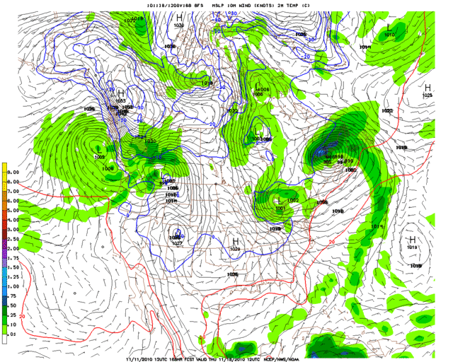
The GFS also shows a 1050mb+ high developing in western Canada by day 6-8 (http://i43.photobucket.com/albums/e371/ ... n_168l.gif).
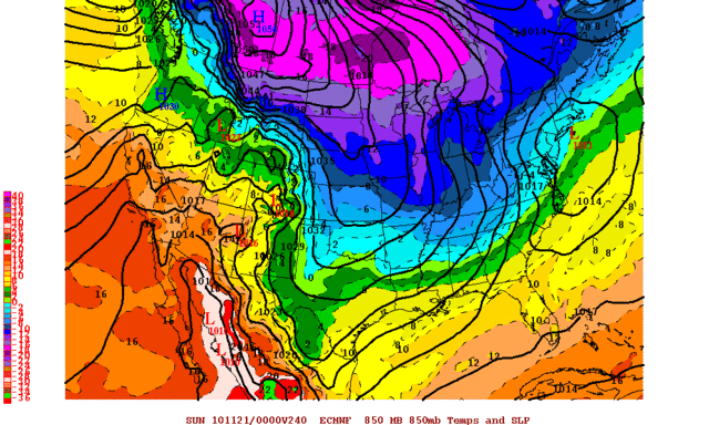
The GFS doesn't seem to handle the situation well in the long range though, with the high pressure center shown weakening as it moves south, and only a moderate push of chilly air entering the USA. I have posted a comparison of the GFS and ECMWF below to show you how differently they handle the situation as we head towards the pre-Thanksgiving weekend...
Comparison of 850mb temperatures and SLP at 00z Sunday, November 21st:
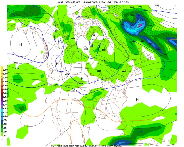
ECMWF (00z run): http://i43.photobucket.com/albums/e371/ ... S240-1.gif
1054mb high pushing south out of Canada. 0C 850mb isotherm has reached the Red River, with the actual strong surface front much further south. -10C 850mb isotherm as far south as Missouri, with the -16C isotherm entering the northern USA. Not the coldest arctic outbreak relative to mid-winter events, but still pretty significant for November.
GFS (12z run): http://i43.photobucket.com/albums/e371/ ... 228l-1.gif
No strong high pushing out of Canada. 0C 850mb isotherm is near the KS/NE border. -10C 850mb isotherm up near Minnesota and northern South Dakota. Overall a pretty typical mid/late November weather map, with no significant arctic outbreak underway.
The GFS doesn't seem to handle the situation well in the long range though, with the high pressure center shown weakening as it moves south, and only a moderate push of chilly air entering the USA. I have posted a comparison of the GFS and ECMWF below to show you how differently they handle the situation as we head towards the pre-Thanksgiving weekend...
Comparison of 850mb temperatures and SLP at 00z Sunday, November 21st:
ECMWF (00z run): http://i43.photobucket.com/albums/e371/ ... S240-1.gif
1054mb high pushing south out of Canada. 0C 850mb isotherm has reached the Red River, with the actual strong surface front much further south. -10C 850mb isotherm as far south as Missouri, with the -16C isotherm entering the northern USA. Not the coldest arctic outbreak relative to mid-winter events, but still pretty significant for November.
GFS (12z run): http://i43.photobucket.com/albums/e371/ ... 228l-1.gif
No strong high pushing out of Canada. 0C 850mb isotherm is near the KS/NE border. -10C 850mb isotherm up near Minnesota and northern South Dakota. Overall a pretty typical mid/late November weather map, with no significant arctic outbreak underway.
0 likes
-
Extremeweatherguy
- Category 5
- Posts: 11095
- Joined: Mon Oct 10, 2005 8:13 pm
- Location: Florida
Re: Winter 2010-11 for the Southern Plains
Well, of course, right after posting that comparison, the latest run of the ECMWF has now removed the 1054mb high from the 240-hour weather map, and now shows a much weaker high pushing down the plains. Still looks colder than the GFS though...
0 likes
Who is online
Users browsing this forum: No registered users and 74 guests