Winter 2010-11 for the Southern Plains
Moderator: S2k Moderators
Forum rules
 The posts in this forum are NOT official forecast and should not be used as such. They are just the opinion of the poster and may or may not be backed by sound meteorological data. They are NOT endorsed by any professional institution or STORM2K.

The posts in this forum are NOT official forecast and should not be used as such. They are just the opinion of the poster and may or may not be backed by sound meteorological data. They are NOT endorsed by any professional institution or STORM2K.
-
Portastorm

- Storm2k Moderator

- Posts: 9954
- Age: 63
- Joined: Fri Jul 11, 2003 9:16 am
- Location: Round Rock, TX
- Contact:
Re: Winter 2010-11 for the Southern Plains
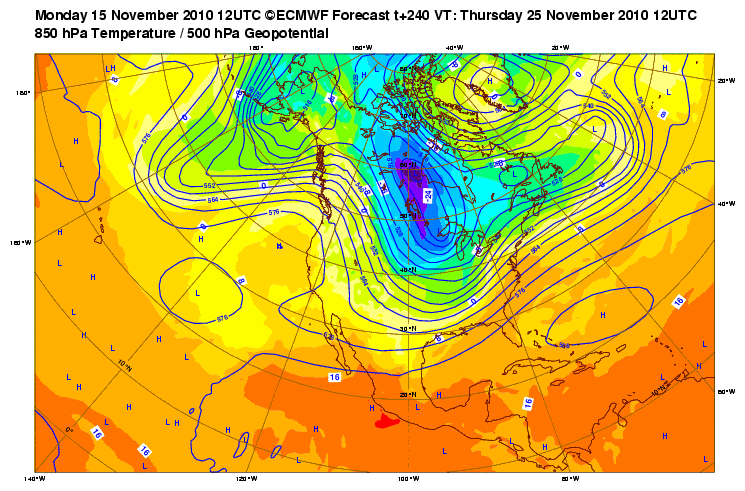
As for today's 12z runs at 240 hrs, the Euro shows a 1034 mb high coming down the lee side of the Rockies while the GFS shows a stronger high at 1044 mb.
0 likes
-
HockeyTx82
- S2K Supporter

- Posts: 2787
- Joined: Tue Oct 27, 2009 11:17 am
- Location: Ponder, TX
Re: Winter 2010-11 for the Southern Plains
From our friends at the Ft Worth NWS.........
.PREV DISCUSSION... /ISSUED 307 AM CST SUN NOV 14 2010/
AFTER A COOL MORNING WITH SOME PATCHY FROST ACROSS THE NORTHWEST
HALF OF THE REGION...A SLIGHTLY WARMER DAY IS EXPECTED WITH HIGH
TEMPERATURES GENERALLY IN THE LOWER AND MIDDLE 60S. SOME MID LEVEL
CLOUDS WILL COVER THE SOUTHERN ZONES THIS MORNING...OTHERWISE A
MOSTLY SUNNY DAY IS EXPECTED. MODELS CONTINUE TO INDICATE
ISENTROPIC LIFT INCREASING OVER SOUTH TEXAS TODAY WITH SOME LIGHT
RAIN POSSIBLE OVER THE SOUTHERN ZONES OVER NORTH TEXAS BY THIS
EVENING. LOW RAIN CHANCES WILL LINGER OVER THE SOUTHEAST SECTIONS
MONDAY. AN UPPER LEVEL TROUGH AND WEAK COLD FRONT WILL MOVE ACROSS
THE REGION MONDAY NIGHT/TUESDAY MORNING AND BRING SCATTERED
SHOWERS WITH THE BEST RAIN CHANCES EAST OF INTERSTATE 35.
THE REMAINDER OF THE WEEK SHOULD BE DRY WITH A BUILDING RIDGE IN
THE WEST AND A REINFORCEMENT OF COOL AND DRY AIR EXPECTED WITH THE
PASSAGE OF A COLD FRONT WEDNESDAY. LOW LEVEL MOISTURE WILL BEGIN
TO RETURN BY THE WEEKEND AS A LEE TROUGH DEVELOPS ACROSS THE HIGH
PLAINS IN RESPONSE TO A DEVELOPING SYSTEM ACROSS THE WESTERN U.S.
MODELS CONTINUE TO HOLD ALL UPPER DYNAMICS ASSOCIATED WITH THIS
SYSTEM WEST OF THE REGION THROUGH SUNDAY. HOWEVER SOME LIGHT RAIN
IN AN INCREASING WARM AIR ADVECTION PATTERN WILL BE POSSIBLE
SUNDAY.
THE EXTENDED MODELS ARE NOW LOOKING MUCH LESS LIKELY FOR AN
INTRUSION OF MUCH COLDER AIR TO NORTH TEXAS THE WEEK OF THANKSGIVING.
0 likes
Don't hold me accountable for anything I post on this forum. Leave the real forecasting up to the professionals.
Location: Ponder, TX (all observation posts are this location unless otherwise noted)
Location: Ponder, TX (all observation posts are this location unless otherwise noted)
-
Portastorm
- Storm2k Moderator
- Posts: 9954
- Age: 63
- Joined: Fri Jul 11, 2003 9:16 am
- Location: Round Rock, TX
- Contact:
Re: Winter 2010-11 for the Southern Plains
Hockey, that is true. However, I will point out that some very sharp weather minds elsewhere suggest the longer-range modeling is really struggling right now with the pattern and its volatility.
I'm not being a shill for cold weather here ... I would say the same if the models were advertising warm and switched to cold. Just something to keep in mind. Wouldn't surprise me to see the models switch back tonight or tomorrow.
I'm not being a shill for cold weather here ... I would say the same if the models were advertising warm and switched to cold. Just something to keep in mind. Wouldn't surprise me to see the models switch back tonight or tomorrow.
0 likes
-
Texas Snowman

- Storm2k Moderator
- Posts: 6197
- Joined: Fri Jan 25, 2008 11:29 am
- Location: Denison, Texas
Re: Winter 2010-11 for the Southern Plains
I would also remind that the NWS skill set regarding winter weather, cold weather intrusions isn't that great in this part of the world. Case in point, the record DFW snowstorm last February that the local office refused to buy into until it was actually underway.
Point being made is that something still nearly two weeks away, I don't even begin to trust a snippet out of a morning forecast discussion....whether it is warm or cold.
Point being made is that something still nearly two weeks away, I don't even begin to trust a snippet out of a morning forecast discussion....whether it is warm or cold.
0 likes
The above post and any post by Texas Snowman is NOT an official forecast and should not be used as such. It is just the opinion of the poster and may or may not be backed by sound meteorological data. It is NOT endorsed by any professional institution including storm2k.org. For official information, please refer to NWS products.


Re: Winter 2010-11 for the Southern Plains
Texas Snowman wrote:I would also remind that the NWS skill set regarding winter weather, cold weather intrusions isn't that great in this part of the world. ...
Point being made is that something still nearly two weeks away, I don't even begin to trust a snippet out of a morning forecast discussion....whether it is warm or cold.
This is VERY true at least in the deep south. I'm accustomed to checking out temps daily during winter for duck hunting and the NWS forecasts from the morning are commonly 5-10 off, either direction.
0 likes
-
SouthernMet

- Category 3

- Posts: 857
- Joined: Sun Aug 29, 2010 8:23 pm
- Location: fort worth, tx
Re: Winter 2010-11 for the Southern Plains
Watching model period from Wed 11/24 - Friday 11/26. As models initialize possible winter weather across Oklahoma.
0 likes
Nothing that SouthernMet posts, is an official forecast,nor does it reflect views of STORM2K.. SouthernMet is just adding to the great discussions on STORM2K.. Refer to NWS for official forecasts.

Re: Winter 2010-11 for the Southern Plains
Texas Snowman wrote:I would also remind that the NWS skill set regarding winter weather, cold weather intrusions isn't that great in this part of the world. Case in point, the record DFW snowstorm last February that the local office refused to buy into until it was actually underway.
Point being made is that something still nearly two weeks away, I don't even begin to trust a snippet out of a morning forecast discussion....whether it is warm or cold.
I'm trying to remember how that went down last year. I remember them uping the total amount every like hour, though.
0 likes
-
srainhoutx

- S2K Supporter
- Posts: 6919
- Age: 68
- Joined: Sun Jan 14, 2007 11:34 am
- Location: Haywood County, NC
- Contact:
Re: Winter 2010-11 for the Southern Plains
This is one of the best discussions from a local WFO I have seen in a long time regarding all the players and the effects felt downstream...
Dodge City, KS...
DAYS 3-7...
TROPICAL THUNDERSTORMS REMAIN ACTIVE IN THE INDIAN OCEAN, BUT
ACTIVITY HAS DECREASED IN THE MARITIME CONTINENT IN RECENT DAYS.
ATMOSPHERIC RELATIVE ANGULAR MOMENTUM HAS DECREASED TO NEARLY TWO
STANDARD DEVIATIONS BELOW CLIMATOLOGY, AND TENDENCIES STILL ARE
NEGATIVE. HOWEVER, MOUNTAIN TORQUE HAS BEGUN TO INCREASE LARGELY DUE
TO A POSITIVE CONTRIBUTION FROM THE ANDES IN SOUTH AMERICA. THE
WHEELER-HENDON MJO PHASE SPACE DIAGRAM SUGGESTS THAT THE REMNANTS OF
A MJO OSCILLATION MAY BE PROGRESSING RAPIDLY EASTWARD ACROSS THE
WESTERN HEMISPHERE. THIS FEATURE LIKELY WILL ENHANCE CONVECTION IN
THE INDIAN OCEAN LATE THIS WEEK INTO NEXT WEEK. THE ATMOSPHERE
APPEARS TO BE OSCILLATING THROUGH PHASE 1-2 TOWARD PHASE 3-4 OF THE
BERRY/WEICKMANN GLOBAL WIND OSCILLATION. PHASES 3 AND 4 FAVOR
RIDGING IN THE WESTERN UNITED STATES AND UPPER LEVEL HIGH PRESSURE
AROUND 160W WITH A MEAN TROUGH IN THE EASTERN PACIFIC.
THE NUMERICAL MODELS TODAY ARE IN GOOD AGREEMENT ON THE EVOLUTION OF
THE LARGE SCALE FLOW THROUGH LATE NOVEMBER. THE UPPER LEVEL RIDGE
NEAR 135-140W WILL BUILD INTO THE WESTERN UNITED STATES WHILE A
SHARP UPPER LEVEL RIDGE BUILDS AROUND 160W BY 18 NOVEMBER. A SLOWLY
PROGRESSIVE LONG WAVE PATTERN SUPPORTS PROGRESSION OF A LONG WAVE
TROUGH TO THE CENTRAL PLAINS BY 22-23 NOVEMBER. A LOBE OF THE POLAR
VORTEX WILL DEEPEN IN CENTRAL CANADA BY THE WEEKEND, AND A STRONG
TROUGH ROTATING AROUND THE VORTEX WILL MOVE ACROSS SOUTHERN CANADA
22-23 NOVEMBER. THIS WILL OPEN THE DOOR FOR AN INVASION OF
SHALLOW ARCTIC AIR IN THE CENTRAL UNITED STATES AROUND 22
NOVEMBER, ALTHOUGH CONFIDENCE IN SYNOPTIC SCALE DETAILS THAT FAR OUT
IS LOW. THE ECMWF IS MORE PROGRESSIVE WITH THE CENTRAL UNITED STATES
TROUGH THAN THE GFS AND PROBABLY IS MORE REASONABLE.
IN THE DAY 4-7 PERIOD, THE NUMERICAL MODELS AGREE REMARKABLY WELL.
THE STRONG UPPER LEVEL TROUGH NEAR 165W WILL PROPAGATE OVER THE
WEAKENING EASTERN PACIFIC RIDGE AND MOVE ACROSS THE CENTRAL PLAINS
TUESDAY NIGHT AND WEDNESDAY MORNING. LOW LEVEL OFFSHORE FLOW WILL
CONTINUE ALONG THE GULF COAST THROUGH WEDNESDAY, AND LOW LEVEL
MOISTURE WILL BE EXTREMELY LIMITED IN THE CENTRAL PLAINS AS THE
UPPER LEVEL TROUGH RIPPLES THROUGH THE FLOW. INSTABILITY WITH THE
UPPER LEVEL COLD POOL AND UPPER LEVEL DIVERGENCE IN THE EXIT REGION
OF THE JET STREAK MAY BE SUFFICIENT TO SUPPORT LIGHT PRECIPITATION
IN NORTHERN KANSAS AND SOUTHERN NEBRASKA LATE TUESDAY NIGHT AND
EARLY WEDNESDAY, BUT THE POTENTIAL FOR MEASURABLE PRECIPITATION IS
VERY LOW SOUTH OF INTERSTATE 70. TEMPERATURES IN THE LOWER LEVELS OF
THE ATMOSPHERE WILL BE WARM ENOUGH THAT PRECIPITATION SHOULD FALL IN
LIQUID FORM.
AS THE LONG WAVE TROUGH DEEPENS IN THE EASTERN PACIFIC LATE THIS
WEEK, INCREASING FLOW PERPENDICULAR TO THE ROCKIES WILL SUPPORT
STRONG TROUGHING IN THE LEE OF THE MOUNTAINS THURSDAY AND FRIDAY.
TEMPERATURES SHOULD WARM BACK INTO THE 60S NEAR THE COLORADO BORDER
THURSDAY, AND HIGHS NEAR 70 CAN BE EXPECTED IN FAR WESTERN KANSAS
FRIDAY. DEWPOINTS WILL BE IN THE 20S IN MOST AREAS, AND RELATIVE
HUMIDITIES WILL APPROACH RED FLAG CRITERIA BOTH THURSDAY AND FRIDAY.
AN UPPER LEVEL TROUGH WILL MOVE THROUGH SOUTHERN CANADA TO THE GREAT
LAKES BY SATURDAY MORNING, AND A SHALLOW SURGE OF COOL AIR WILL WORK
ACROSS KANSAS FRIDAY NIGHT. THERE WILL BE A SUBSTANTIAL TEMPERATURE
GRADIENT IN WESTERN KANSAS SATURDAY WITH TEMPERATURES IN THE UPPER
60S AND LOWER 70S WHERE THE SHALLOW COLD AIR MIXES OUT AND NEARLY 20
DEGREES COOLER NORTH OF THE BOUNDARY. ANOTHER UPPER LEVEL TROUGH
WILL MOVE FROM THE SOUTHWESTERN UNITED STATES TO THE NORTHERN PLAINS
SUNDAY. THE SHALLOW COLD AIR WILL RETREAT NORTHWARD SATURDAY NIGHT
AND MAKE ANOTHER SURGE SOUTHWARD ON SUNDAY. CONFIDENCE IN THE
STRENGTH AND TIMING OF THE TROUGHS RIPPLING THROUGH THE STRONG
SOUTHWEST UPPER LEVEL FLOW IS NOT HIGH, AND THE PRESENCE OF A SHARP
LOW LEVEL BAROCLINIC ZONE WALLOWING BACK AND FORTH IN KANSAS MAKES
TEMPERATURE FORECASTS HIGHLY SUSCEPTIBLE TO SIGNIFICANT ERRORS
DURING THE WEEKEND. THE ECMWF SEEMS TO HAVE A TENDENCY TO SCOUR OUT
SHALLOW COOL AIR TOO QUICKLY, AND THE GFS LARGELY WAS USED AS A
FIRST GUESS ON FRONTAL POSITIONS SATURDAY AND SUNDAY.
0 likes
Carla/Alicia/Jerry(In The Eye)/Michelle/Charley/Ivan/Dennis/Katrina/Rita/Wilma/Ike/Harvey
Member: National Weather Association
Wx Infinity Forums
http://wxinfinity.com/index.php
Facebook.com/WeatherInfinity
Twitter @WeatherInfinity
Member: National Weather Association
Wx Infinity Forums
http://wxinfinity.com/index.php
Facebook.com/WeatherInfinity
Twitter @WeatherInfinity
-
Portastorm
- Storm2k Moderator
- Posts: 9954
- Age: 63
- Joined: Fri Jul 11, 2003 9:16 am
- Location: Round Rock, TX
- Contact:
Re: Winter 2010-11 for the Southern Plains
Nice find, srainhoutx!
I think it was a winter season or two ago that I made a similar comment on the quality of forecast discussions coming out of the Dodge City, KS NWS office. They are really good at looking at the big picture and how it may impact the Plains.
I think it was a winter season or two ago that I made a similar comment on the quality of forecast discussions coming out of the Dodge City, KS NWS office. They are really good at looking at the big picture and how it may impact the Plains.
0 likes
-
wall_cloud

- Professional-Met

- Posts: 401
- Age: 49
- Joined: Sun Dec 04, 2005 7:32 am
- Location: Bartlett, TN
- Contact:
Temperatures in Canada are not incredibly cold yet and that is to be expected since we are still just in mid November. However, this pattern does depict a hint of cross-polar flow setting up by late week which could tap into some colder Siberian air. Both the ECMWF and GFS are showing a nice E-W oriented h5 trof axis across Canada with a strong anticyclone located over the Aleutians by 12z Thursday. This is reminiscent of the McFarland Signature that is used as a preliminary indicator of a cold air dump. Now the low that eventually will swing across the CONUS is progged to weaken with time evolving into more of an open wave as it crosses the Rockies early next week. The ECMWF does bring this trof farther south than the GFS which is reasonable depending on where the strongest baroclinic zone sets up.
That said, snow pack is meager to say the least across Canada and the prairie provinces may not have much at all by late week. The lack of snow pack combined with a higher sun angle than we'll see in a month will lead to quicker modification of any cold airmass that moves south. The cold air is likely to be more of a factor over the central/northern Plains ala the Dodge City AFD but sometimes these stronger airmasses move much farther south than anticipated. Its something to keep an eye on but its also not something that I'm overly excited about for my location in Texas.
That said, snow pack is meager to say the least across Canada and the prairie provinces may not have much at all by late week. The lack of snow pack combined with a higher sun angle than we'll see in a month will lead to quicker modification of any cold airmass that moves south. The cold air is likely to be more of a factor over the central/northern Plains ala the Dodge City AFD but sometimes these stronger airmasses move much farther south than anticipated. Its something to keep an eye on but its also not something that I'm overly excited about for my location in Texas.
0 likes
My comments are my own and do not reflect those of NOAA or the National Weather Service.

Great post wall_cloud! Nice to hear thoughts from a pro met about the upcoming pattern.
One thing I have wondered (not a jab at you or anyone else about this topic) but a lot of times I hear people mention high sun angles. I don't understand how that plays such an important role this time of year because really it's no different than the sun angle for late January (Dec 21st being the lowest point). It's the surface and near surface features that I assume would be the biggest factors. I have no extensive knowledge on this so that's just my two cents...
One thing I have wondered (not a jab at you or anyone else about this topic) but a lot of times I hear people mention high sun angles. I don't understand how that plays such an important role this time of year because really it's no different than the sun angle for late January (Dec 21st being the lowest point). It's the surface and near surface features that I assume would be the biggest factors. I have no extensive knowledge on this so that's just my two cents...
0 likes
The above post and any post by Ntxw is NOT an official forecast and should not be used as such. It is just the opinion of the poster and may or may not be backed by sound meteorological data. It is NOT endorsed by any professional institution including Storm2k. For official information, please refer to NWS products.
Help support Storm2K!
-
amawea

- S2K Supporter
- Posts: 385
- Age: 74
- Joined: Mon Aug 09, 2004 3:36 pm
- Location: Horseshoe Bend, Ar. but from Baytown, Tx
Re: Winter 2010-11 for the Southern Plains
Well Ntxw, based on what I've read you pretty well answered your own question. I am no pro met but read as much as i can about such things and the surface features are what has a big impact on our temperatures. The transition from warm to cold and cold to warm is the key. January may very well have a sun angle that is comparable or even equal at some point to the November sun angle but in the northern hemisphere winter we are going from warm to cold in November and cold to warm in regards to sun angle in January. There is a delayed reaction to the suns angle and its affect on the temperatures. It takes a while for the earth to cool going into our winter just as it takes a while for it to warm back up going into spring. So, surface temps around the globe respond to sun angle but it takes a few weeks to see the results.
Someone correct me if I am mistaken but I have read this explanation before.

Someone correct me if I am mistaken but I have read this explanation before.
0 likes
Re: Winter 2010-11 for the Southern Plains
amawea wrote:Well Ntxw, based on what I've read you pretty well answered your own question. I am no pro met but read as much as i can about such things and the surface features are what has a big impact on our temperatures. The transition from warm to cold and cold to warm is the key. January may very well have a sun angle that is comparable or even equal at some point to the November sun angle but in the northern hemisphere winter we are going from warm to cold in November and cold to warm in regards to sun angle in January. There is a delayed reaction to the suns angle and its affect on the temperatures. It takes a while for the earth to cool going into our winter just as it takes a while for it to warm back up going into spring. So, surface temps around the globe respond to sun angle but it takes a few weeks to see the results.
Someone correct me if I am mistaken but I have read this explanation before.
You're absolutely right. What I was just wondering (even the snowstorm here in March) many doubted it saying the sun angle won't allow for accumulations etc. I guess it's a pet peeve of mine you'd say when someone mentions sun angle for forecast to such a degree. I do understand why that is though.
0 likes
The above post and any post by Ntxw is NOT an official forecast and should not be used as such. It is just the opinion of the poster and may or may not be backed by sound meteorological data. It is NOT endorsed by any professional institution including Storm2k. For official information, please refer to NWS products.
Help support Storm2K!
Help support Storm2K!
-
wall_cloud
- Professional-Met
- Posts: 401
- Age: 49
- Joined: Sun Dec 04, 2005 7:32 am
- Location: Bartlett, TN
- Contact:
Re: Winter 2010-11 for the Southern Plains
the sun angle won't really impact accumulations locally per se, but would have more impact on the long term evolution of a system. The same argument is often made about the ground being too warm for snow. If it snows heavy enough, it WILL accumulate. trust me.
As for the sun angle, it will work over the period of several days to weeks on an airmass. The higher angle obviously supplies more solar energy per unit area. This increases the "efficiency" of the sun to heat the ground. If the angle is low, the same amount of insolation is spread out over a large area. Also, a higher sun angle results in less atmospheric attenuation of the solar radiation.
As amawea pointed out, yes we are going from warm to cold so the sun angle is still decreasing (through the solstice anyway). By that time, we should have plenty of cold air bottled up but right now we just haven't seen all that much. That was more my point. It was just poorly articulated.
0 likes
My comments are my own and do not reflect those of NOAA or the National Weather Service.
-
srainhoutx
- S2K Supporter
- Posts: 6919
- Age: 68
- Joined: Sun Jan 14, 2007 11:34 am
- Location: Haywood County, NC
- Contact:
Re: Winter 2010-11 for the Southern Plains
HPC:
USED PRIMARILY THE 00Z ECMWF TO UPDATE THE PRELIMINARY FRONTS AND
PRESSURES FOR DAYS 3 THROUGH 6...WITH A SHIFT TOWARDS THE 00Z
ECENS MEAN DAY 7 TO ADDRESS THE UNCERTAINTIES IN SYNOPTIC DETAIL
INHERENT AT THAT TIME RANGE. THE MODELS ARE IN ABOVE AVERAGE
AGREEMENT FOR THIS FORECAST PERIOD...WITH A WEDGE OF MODIFIED
ARCTIC AIR OVER WESTERN CANADA CUTTING DOWN ON THE DOMAIN IN WHICH
THE OPEN FLOW ACROSS THE CONTINENT COULD BE HANDLED DISPARATELY BY
THE GUIDANCE. THE EUROPEAN GUIDANCE WAS USED OVER THE OTHER
MODELS FOR SURFACE PRESSURES...SINCE BY AND LARGE...IT CONTINUES
TO MAINTAIN A VERIFICATION EDGE DURING THE MEDIUM RANGE. THE
TIMING OF THE WAVE RIPPLING ALONG THE POLAR FRONT OVER THE CENTRAL
STATES TOWARD THE END OF THE PERIOD IS PROBABLY THE BIGGEST
QUESTION MARK...WITH THE ECMWF AND GEM GLOBAL ON THE FAST SIDE OF
THE GUIDANCE.
0 likes
Carla/Alicia/Jerry(In The Eye)/Michelle/Charley/Ivan/Dennis/Katrina/Rita/Wilma/Ike/Harvey
Member: National Weather Association
Wx Infinity Forums
http://wxinfinity.com/index.php
Facebook.com/WeatherInfinity
Twitter @WeatherInfinity
Member: National Weather Association
Wx Infinity Forums
http://wxinfinity.com/index.php
Facebook.com/WeatherInfinity
Twitter @WeatherInfinity
-
HockeyTx82
- S2K Supporter
- Posts: 2787
- Joined: Tue Oct 27, 2009 11:17 am
- Location: Ponder, TX
Re: Winter 2010-11 for the Southern Plains
srainhoutx wrote:HPC:
USED PRIMARILY THE 00Z ECMWF TO UPDATE THE PRELIMINARY FRONTS AND
PRESSURES FOR DAYS 3 THROUGH 6...WITH A SHIFT TOWARDS THE 00Z
ECENS MEAN DAY 7 TO ADDRESS THE UNCERTAINTIES IN SYNOPTIC DETAIL
INHERENT AT THAT TIME RANGE. THE MODELS ARE IN ABOVE AVERAGE
AGREEMENT FOR THIS FORECAST PERIOD...WITH A WEDGE OF MODIFIED
ARCTIC AIR OVER WESTERN CANADA CUTTING DOWN ON THE DOMAIN IN WHICH
THE OPEN FLOW ACROSS THE CONTINENT COULD BE HANDLED DISPARATELY BY
THE GUIDANCE. THE EUROPEAN GUIDANCE WAS USED OVER THE OTHER
MODELS FOR SURFACE PRESSURES...SINCE BY AND LARGE...IT CONTINUES
TO MAINTAIN A VERIFICATION EDGE DURING THE MEDIUM RANGE. THE
TIMING OF THE WAVE RIPPLING ALONG THE POLAR FRONT OVER THE CENTRAL
STATES TOWARD THE END OF THE PERIOD IS PROBABLY THE BIGGEST
QUESTION MARK...WITH THE ECMWF AND GEM GLOBAL ON THE FAST SIDE OF
THE GUIDANCE.
Please forgive me but what does this mean? While I have learned alot on this board I still have a ways to go.
0 likes
Don't hold me accountable for anything I post on this forum. Leave the real forecasting up to the professionals.
Location: Ponder, TX (all observation posts are this location unless otherwise noted)
Location: Ponder, TX (all observation posts are this location unless otherwise noted)
-
srainhoutx
- S2K Supporter
- Posts: 6919
- Age: 68
- Joined: Sun Jan 14, 2007 11:34 am
- Location: Haywood County, NC
- Contact:
Re: Winter 2010-11 for the Southern Plains
Basically, the cold air is coming. Will it be modified? Certainly. There are issues in guidance regarding the storm system rotating around the Polar Vortex into the Plains and the timing or rippling that the HPC is referring to is the big question mark via overnight guidance. Stay Tuned. One thing that also is of note is the storminess that will lead to building some snow pack to our N. That will play a big role on any future Arctic intrusions and airmass modification that may well occur in the active pattern ahead.
0 likes
Carla/Alicia/Jerry(In The Eye)/Michelle/Charley/Ivan/Dennis/Katrina/Rita/Wilma/Ike/Harvey
Member: National Weather Association
Wx Infinity Forums
http://wxinfinity.com/index.php
Facebook.com/WeatherInfinity
Twitter @WeatherInfinity
Member: National Weather Association
Wx Infinity Forums
http://wxinfinity.com/index.php
Facebook.com/WeatherInfinity
Twitter @WeatherInfinity
-
srainhoutx
- S2K Supporter
- Posts: 6919
- Age: 68
- Joined: Sun Jan 14, 2007 11:34 am
- Location: Haywood County, NC
- Contact:
Re: Winter 2010-11 for the Southern Plains
Oh boy...
0 likes
Carla/Alicia/Jerry(In The Eye)/Michelle/Charley/Ivan/Dennis/Katrina/Rita/Wilma/Ike/Harvey
Member: National Weather Association
Wx Infinity Forums
http://wxinfinity.com/index.php
Facebook.com/WeatherInfinity
Twitter @WeatherInfinity
Member: National Weather Association
Wx Infinity Forums
http://wxinfinity.com/index.php
Facebook.com/WeatherInfinity
Twitter @WeatherInfinity
-
HockeyTx82
- S2K Supporter
- Posts: 2787
- Joined: Tue Oct 27, 2009 11:17 am
- Location: Ponder, TX
Re: Winter 2010-11 for the Southern Plains
0 likes
Don't hold me accountable for anything I post on this forum. Leave the real forecasting up to the professionals.
Location: Ponder, TX (all observation posts are this location unless otherwise noted)
Location: Ponder, TX (all observation posts are this location unless otherwise noted)
-
somethingfunny

- ChatStaff

- Posts: 3926
- Age: 37
- Joined: Thu May 31, 2007 10:30 pm
- Location: McKinney, Texas
Re: Winter 2010-11 for the Southern Plains
HockeyTx82 wrote::uarrow: Oh boy what? That looks like some cold air coming down this way if I am reading it correctly.
Looks to me like that run has it missing us off to the east.
0 likes
I am not a meteorologist, and any posts made by me are not official forecasts or to be interpreted as being intelligent. These posts are just my opinions and are probably silly opinions.
Who is online
Users browsing this forum: No registered users and 57 guests