Winter 2010-11 for the Southern Plains

Winter Weather Discussion

Moderator: S2k Moderators

Forum rules

The posts in this forum are NOT official forecast and should not be used as such. They are just the opinion of the poster and may or may not be backed by sound meteorological data. They are NOT endorsed by any professional institution or STORM2K.

Help Support Storm2K
Message
Author
User avatar
Portastorm
Storm2k Moderator
Storm2k Moderator
Posts: 9914
Age: 63
Joined: Fri Jul 11, 2003 9:16 am
Location: Round Rock, TX
Contact:

Re:

#341 Postby Portastorm » Thu Dec 02, 2010 9:28 am

Ntxw wrote:As hard as it is for me to say this, but basically the globals and ensembles have diverged on a general solution less than a week now out, (minus the finer details) which usually means that's how it will likely end up. Barring something major to change, doesn't look like a significant winter storm is brewing for the southern plains...hope I am dead wrong.

*Insignificant note: Euro is barking at another storm late next weekend, but I've been burned enough this week to take that without any meaning :P


Ah, you are now learning, young padawan! :lol:
0 likes   

orangeblood
S2K Supporter
S2K Supporter
Posts: 3714
Joined: Tue Dec 15, 2009 6:14 pm
Location: Fort Worth, TX

Re: Winter 2010-11 for the Southern Plains

#342 Postby orangeblood » Thu Dec 02, 2010 10:29 am

Ntxw - there's still some hope. 25% of the 0Z gfs ensemble members are showing a decent winter storm moving through on Monday night.
0 likes   

User avatar
Extremeweatherguy
Category 5
Category 5
Posts: 11095
Joined: Mon Oct 10, 2005 8:13 pm
Location: Florida

Re: Winter 2010-11 for the Southern Plains

#343 Postby Extremeweatherguy » Thu Dec 02, 2010 11:24 am

Today's 12z run of the GFS looks even less promising. Probably just a few scattered flurries around Monday night if this run were to verify.

While the snow potential is decreasing, the cold magnitude looks to be increasing. The GFS MOS guidance is showing highs in OKC only in the lower 40s Sunday through Tuesday with lows in the lower 20s Monday morning through Wednesday morning. These numbers have been coming down over time though, and since the MOS typically is biased too warm for arctic airmasses, this means we could easily be looking at our first morning lows in the teens next week. Brr..
0 likes   

User avatar
Extremeweatherguy
Category 5
Category 5
Posts: 11095
Joined: Mon Oct 10, 2005 8:13 pm
Location: Florida

#344 Postby Extremeweatherguy » Thu Dec 02, 2010 12:05 pm

The 12z CMC continues to be a little more bullish than the GFS on the upper-level feature Monday night into Tuesday, showing a band of precipitation swinging through Oklahoma during that timeframe...

http://www.weatheroffice.gc.ca/data/mod ... 12_108.jpg

http://www.weatheroffice.gc.ca/data/mod ... 12_120.jpg

http://www.weatheroffice.gc.ca/data/mod ... 12_132.jpg
0 likes   

User avatar
Ntxw
Storm2k Moderator
Storm2k Moderator
Posts: 22785
Joined: Wed Oct 21, 2009 6:34 pm
Location: DFW, Texas

Re: Winter 2010-11 for the Southern Plains

#345 Postby Ntxw » Thu Dec 02, 2010 4:17 pm

12z runs still isn't quite in our favor. Still looks like parts of Oklahoma has the best chances at seeing flakes.

Despite previous predictions, it looks like the NAO could be tanking here in a few weeks coupled possibly with some sort of +PNA. This would mean continual chances of arctic intrusions east of the Rockies perhaps up until the Christmas period.

Image
0 likes   
The above post and any post by Ntxw is NOT an official forecast and should not be used as such. It is just the opinion of the poster and may or may not be backed by sound meteorological data. It is NOT endorsed by any professional institution including Storm2k. For official information, please refer to NWS products.

  Help support Storm2K!
Help Support Storm2K

User avatar
Extremeweatherguy
Category 5
Category 5
Posts: 11095
Joined: Mon Oct 10, 2005 8:13 pm
Location: Florida

Re: Winter 2010-11 for the Southern Plains

#346 Postby Extremeweatherguy » Thu Dec 02, 2010 5:01 pm

From the afternoon OUN forecast discussion...


THE NEXT CONCERN IS THE COLD FRONT THAT IS DUE TO ARRIVE FRIDAY
NIGHT/SATURDAY MORNING. THE NAM APPEARS TO BE A SLOW OUTLIER... SO
WE HAVE DISREGARDED ITS WARM TEMPERATURES FOR SATURDAY. THE GFS
HAS BEEN DOING A REASONABLY GOOD JOB WITH COLD AIR INTRUSIONS THIS
SEASON SO FAR... AND IT LOOKS GOOD AGAIN THIS TIME AROUND.

WE HAVE RETAINED THE FLURRIES SUNDAY NIGHT AND THE SLIGHT CHANCES
FOR LIGHT SNOW MONDAY NIGHT AND TUESDAY. THE GFS AND ECMWF...
ALTHOUGH QUITE DIFFERENT IN DETAILS... BOTH SHOW A MEDIUM-STRENGTH
MID-LEVEL WAVE AFFECTING THE REGION MONDAY NIGHT/TUESDAY... BUT
VERY DRY AIR WILL GREATLY LIMIT ANY PRECIPITATION AMOUNTS. AS
THINGS LOOK RIGHT NOW... THIS EVENT WILL BE QUITE TRIVIAL.


THE PREVIOUS FORECAST HAD THE SAME GENERAL IDEA... AND WE SAW NO
REASON TO MAKE ANY CHANGES BEYOND TOMORROW EVENING.
0 likes   

User avatar
Ntxw
Storm2k Moderator
Storm2k Moderator
Posts: 22785
Joined: Wed Oct 21, 2009 6:34 pm
Location: DFW, Texas

#347 Postby Ntxw » Fri Dec 03, 2010 1:09 am

Tonight's GFS and GEM are even less in precip coverage. Maybe the panhandle of TX/OK. Trending less cold as well.
0 likes   
The above post and any post by Ntxw is NOT an official forecast and should not be used as such. It is just the opinion of the poster and may or may not be backed by sound meteorological data. It is NOT endorsed by any professional institution including Storm2k. For official information, please refer to NWS products.


  Help support Storm2K!

Help Support Storm2K


User avatar
Extremeweatherguy
Category 5
Category 5
Posts: 11095
Joined: Mon Oct 10, 2005 8:13 pm
Location: Florida

Re: Winter 2010-11 for the Southern Plains

#348 Postby Extremeweatherguy » Fri Dec 03, 2010 3:11 am

Here is a quick run down of the latest GFS, ECMWF and CMC concerning the "possible" light wintry precipitation early next week in Oklahoma.

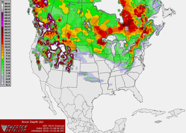
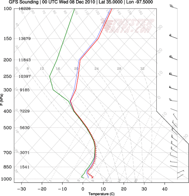
GFS: This is currently the driest model, showing just 0.02" of liquid-equivalent precipitation falling on OKC. The precipitation type, based on the twisterdata.com skew-T output, looks to mainly be in the form of snow within any of the light showers Tuesday morning. This would not be a big deal though, with maximum accumulations only being a light dusting in isolated spots. Most people would probably see nothing, or perhaps just a few flurries.

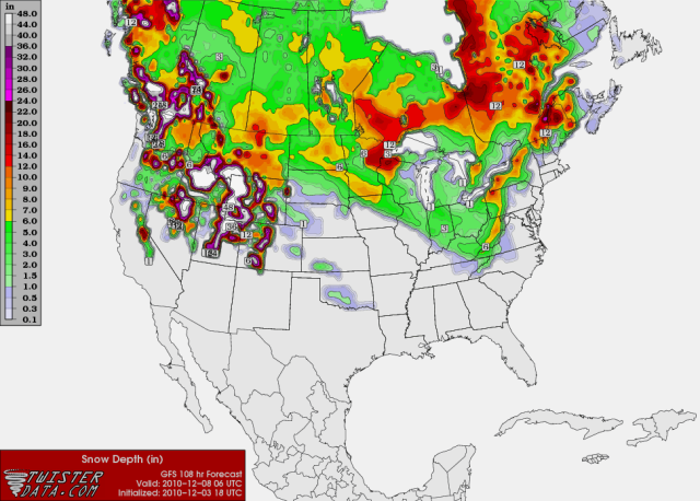
ECMWF: The ECMWF is slightly wetter than the GFS, showing 0.07" of liquid-equivalent precipitation falling on OKC during the day on Tuesday. I do not have access to skew-T output, but based on what I can see, the upper levels look only marginal for snow. Therefore, the light showers might be in the form of a wintry mix of precipitation types. Like the GFS though, I would expect maximum winter precipitation accumulations to stay low, with mainly just a light dusting in isolated spots if this scenario were to be believed. Slightly higher amounts in one or two spots cannot be ruled out though, especially if the ECMWF trends higher than 0.07" in future runs.

CMC: The CMC is the wettest of the three models, but still doesn't show anything too crazy. I do not have access to the text output, but based on the 6-hour precipitation panels (found on the Penn State ewall site), it looks like most from central Oklahoma westwards would see upwards of 0.10" of liquid-equivalent precipitation during the event. Some parts of west-central Oklahoma would even see upwards of 0.25-0.50" of liquid-equivalent precipitation. The upper levels are also cooler on the CMC, so this precipitation would mostly be in the form of snow. If this wetter scenario actually verified, then a good chunk of the western half of the state could see light snow accumulations. If we applied the average 10:1 rule, then the regions seeing the highest liquid-equivalent values (0.25"+) would have the potential to receive over 2.5" of snow. These kind of totals would require winter weather advisory products if they actually came to be.
0 likes   

User avatar
Extremeweatherguy
Category 5
Category 5
Posts: 11095
Joined: Mon Oct 10, 2005 8:13 pm
Location: Florida

Re: Winter 2010-11 for the Southern Plains

#349 Postby Extremeweatherguy » Fri Dec 03, 2010 9:48 am

The 6z GFS has trended toward the 00z CMC and is now showing a swath of accumulating snow across Oklahoma during the day on Tuesday...

Image

The accumulations are light, generally maxing out at 1-2 inches, but it definitely is interesting. Now let's wait and see if the 12z GFS continues this trend, or if it reverts back to the drier 00z scenario.

Update: Ehh, well the 12z GFS looks a little drier again. I think it is still a bit wetter than the 00z run overall, but for OKC in particular it is now showing 0.00" of precipitation next Tuesday...
0 likes   

User avatar
Extremeweatherguy
Category 5
Category 5
Posts: 11095
Joined: Mon Oct 10, 2005 8:13 pm
Location: Florida

Re: Winter 2010-11 for the Southern Plains

#350 Postby Extremeweatherguy » Fri Dec 03, 2010 12:51 pm

The 12z CMC has trended a bit drier now too. It no longer shows the 0.25-0.50"+ precipitation amounts out in west-central Oklahoma like it did on the 00z. It still does show light precipitation for a good chunk of the state though, with minor liquid-equivalent amounts (likely in the form of flurries or light snow showers) falling between midnight and 12pm on Tuesday (0.20" liquid equivalent or less).

All in all, the trend continues to be toward a very inconsequential event. Probably just a few light snow showers or scattered flurries overnight Monday into Tuesday. One or two places could perhaps pick up a quick dusting of accumulation, but overall accumulating snowfall is looking more and more unlikely as the event draws near. Of course, if the upper level feature winds up being slightly more amplified than the current modeling projects, then things could change; but for now, the trend based on the latest GFS and CMC continues to be toward a weaker system with only a minor winter weather threat.
0 likes   

User avatar
Ntxw
Storm2k Moderator
Storm2k Moderator
Posts: 22785
Joined: Wed Oct 21, 2009 6:34 pm
Location: DFW, Texas

#351 Postby Ntxw » Fri Dec 03, 2010 1:49 pm

The air is going to be very dry, so the qpf can be a little misleading. Would take some time for the atmosphere to moisten up. From what I see of the models today (unless the shortwave is stronger than currently depicted) flurries would be the best bet.
0 likes   
The above post and any post by Ntxw is NOT an official forecast and should not be used as such. It is just the opinion of the poster and may or may not be backed by sound meteorological data. It is NOT endorsed by any professional institution including Storm2k. For official information, please refer to NWS products.


  Help support Storm2K!

Help Support Storm2K


User avatar
Extremeweatherguy
Category 5
Category 5
Posts: 11095
Joined: Mon Oct 10, 2005 8:13 pm
Location: Florida

Re: Winter 2010-11 for the Southern Plains

#352 Postby Extremeweatherguy » Fri Dec 03, 2010 5:53 pm

The 18z GFS is once again slightly more amplified with the shortwave, showing 0.07" of liquid-equivalent precipitation falling on OKC during the day on Tuesday (compared to 0.00" on the 12z run). The model keeps swinging back and forth on the QPF output though, depending on the strength of the shortwave in each run, so nothing is set in stone just yet. Once the pacific system rolls onshore later this weekend we should have a much better idea as to what will actually happen early next week.


GFS generated skew-t/log-p map for Oklahoma City valid 6pm Tuesday evening:
Image
Favorable sounding for snow.

18z GFS snowfall accumulation map valid 12am Wednesday:
Image
grayish color indicates areas where the model expects a dusting of snow (<1"), while the light greenish color in Oklahoma indicates areas where the model expects totals near 1-1.5".


UPDATE: The 00z GFS continues the trend of a stronger shortwave, once again showing light snow accumulations across parts of Oklahoma on Tuesday. The orientation of the accumulation band is a little different from the 18z run (located in north Oklahoma instead of southwest Oklahoma), but the fact that it is still there in the first place is significant. Now let's wait and see if this stronger shortwave/wetter trend can keep up through tomorrow...

Also of note, the 00z CMC has trended back toward higher QPF values and a stronger shortwave again as well.
0 likes   

User avatar
Extremeweatherguy
Category 5
Category 5
Posts: 11095
Joined: Mon Oct 10, 2005 8:13 pm
Location: Florida

Re: Winter 2010-11 for the Southern Plains

#353 Postby Extremeweatherguy » Sat Dec 04, 2010 10:47 am

After several days of forecasting a 20% chance of snow for my area, the NWS has decided to change my forecast for Tuesday to a 20% chance of rain (rain/snow mix line literally just north of me). What the heck is up with that? The models don't look any different than they have the last few days, and when they are showing skew-t's like this: http://www.twisterdata.com/data/tmp/scr ... .5000W.png , then I highly doubt the precipitation that fell would be rain. The only way I could see rain being the primary precipitation type would be if the precipitation during the entire event fell during a narrow period during the mid afternoon. Even then though, wetbulbing processes would probably allow a mixing with or changeover to snow. Perhaps this is just a weekend morning shift glitch, and by the afternoon the forecast will revert back to where it had been. We shall see. For now though, I will remain baffled by this sudden switch, as it goes against the current modeling (see the skew-t posted above). If the models start warming some though, then my ideas might change. What bugs me the most right now though is the decision to use "all rain" as the forecast. Even if you were in question of the setup, wouldn't you still at least forecast a rain/snow mix just to cover your bases incase some of those recent GFS and CMC runs showing light accumulations played out? Granted, they do forecast a rain/snow mix for downtown Oklahoma City, but I don't understand the sharp cut off between a mix and all rain they have just south.
0 likes   

User avatar
Extremeweatherguy
Category 5
Category 5
Posts: 11095
Joined: Mon Oct 10, 2005 8:13 pm
Location: Florida

#354 Postby Extremeweatherguy » Sat Dec 04, 2010 11:22 am

A look at the 12z GFS...

Snow accumulations at 12am Wednesday:

Image
It looks like that "20% chance of rain" forecast from the NWS for my location south of OKC would actually be 1-1.5" of snow if this run were to play out.

Skew-T/log-P charts for Oklahoma City:
6am: http://i43.photobucket.com/albums/e371/ ... 75000W.png
12pm: http://i43.photobucket.com/albums/e371/ ... 75000W.png
6pm: http://i43.photobucket.com/albums/e371/ ... 75000W.png
12am: http://i43.photobucket.com/albums/e371/ ... 75000W.png
0 likes   

User avatar
wxman57
Moderator-Pro Met
Moderator-Pro Met
Posts: 22978
Age: 67
Joined: Sat Jun 21, 2003 8:06 pm
Location: Houston, TX (southwest)

Re: Winter 2010-11 for the Southern Plains

#355 Postby wxman57 » Sat Dec 04, 2010 11:51 am

Looks cold enough for snow in OKC, certainly. I've found those snow accumulation charts tend to overestimate accumulations much of the time. The edged of the 1" accumulation is a good estimate of a trace of snow, generally. But if the GFS is underestimating the moisture then you could see more than a trace.
0 likes   

User avatar
Extremeweatherguy
Category 5
Category 5
Posts: 11095
Joined: Mon Oct 10, 2005 8:13 pm
Location: Florida

#356 Postby Extremeweatherguy » Sat Dec 04, 2010 1:29 pm

12z model QPF output for Oklahoma City next Tuesday:

GFS (based on text output): 0.09"

ECMWF (based on text output): 0.01"

CMC (estimated based on graphics): 0.12-0.45"

As you can see, the modeling is still all over the map with this system. The ECMWF remains the driest, while the CMC remains the wettest. The GFS is in between.

If you average these values (using 0.29" for the CMC as a mid point), then the average QPF output for Oklahoma City next Tuesday is currently about 0.20". That is a fairly low amount compared to larger storms, but if a majority of it were to fall as snow, then we could still manage to see around an inch or two (using a 5:1 or 10:1 ratio). Of course, the higher CMC values definitely skew this average, and if only the GFS and ECMWF were taken into account, the average would be closer to 0.05". If that was the case, then I would expect just a dusting (or less) of snow for many.
0 likes   

User avatar
Extremeweatherguy
Category 5
Category 5
Posts: 11095
Joined: Mon Oct 10, 2005 8:13 pm
Location: Florida

Re: Winter 2010-11 for the Southern Plains

#357 Postby Extremeweatherguy » Sat Dec 04, 2010 3:12 pm

Following a 4 sentence forecast discussion this afternoon, the NWS decided to continue forecasting all rain for my location. Since they are obviously differing from the models (especially the GFS/CMC), I would think they would at least offer a more detailed reasoning as to why; but no luck this afternoon. I guess we now just have to sit back, see what the 18z and 00z runs say, and then await their next forecast tomorrow morning. If the models keep trending in the right direction though, then this may very well be one of those situations that involve large last minute forecast changes early next week. Oh the joys of winter weather forecasting...especially with a weak system like this...

BTW: Just to clarify. I am not saying the NWS forecast of all rain is "wrong", because for all I know, it might not be. I am just saying that with the modeling looking the way it does right now, the forecast doesn't make much sense, IMO. At the very least I would expect to see a lengthy discussion of the topic in the AFD addressing all the possibilities, or a "rain/snow mix" in my forecast, but I see neither. The rain/snow mix line starts just to my north. The thing I find most comical though is that yesterday the models looked even less bullish, yet at that time the forecast for my area was "20% chance of snow". Why the sudden change today when the models look even more promising?

Well since I am criticizing another's forecast, I should probably back this up with one of my own to make it fair. As of right now, my forecast for Tuesday would look something like this:
_____________________________________________________________________________________________________________________________

TUESDAY (Areas within a 1-county radius of Oklahoma City).
Issued: 2:54pm 12/4/10

High - low to mid 40s (before precip. begins)

Mostly cloudy with a 40% chance of scattered light precipitation developing during the afternoon. Precipitation should begin as rain, but will mix with or transition to snow as the atmospheric column and surface temperature cools. A light dusting of snow is possible by the time the precipitation ends during the evening. Winds out of the NNE at 5-15mph.
______________________________________________________________________________________________________________________________


The posts in this forum are NOT official forecast and should not be used as such. They are just the opinion of the poster and may or may not be backed by sound meteorological data. They are NOT endorsed by any professional institution or storm2k.org. For official information, please refer to the NHC and NWS products.
0 likes   

User avatar
iorange55
Category 5
Category 5
Posts: 2388
Joined: Thu Nov 13, 2008 9:47 pm
Location: Big D

Re: Winter 2010-11 for the Southern Plains

#358 Postby iorange55 » Sat Dec 04, 2010 5:14 pm

Looks to me the 18z shows the precip going a little further south and shows a bit more precip? Also as far as I'm seeing it would be all snow north of the Oklahoma border. I'm just as confused as you are EWG.
0 likes   

User avatar
srainhoutx
S2K Supporter
S2K Supporter
Posts: 6919
Age: 67
Joined: Sun Jan 14, 2007 11:34 am
Location: Haywood County, NC
Contact:

Re: Winter 2010-11 for the Southern Plains

#359 Postby srainhoutx » Sat Dec 04, 2010 5:33 pm

Yeah the 18Z GFS suggests trace amounts of snow in SE TX/SW LA. :P
0 likes   
Carla/Alicia/Jerry(In The Eye)/Michelle/Charley/Ivan/Dennis/Katrina/Rita/Wilma/Ike/Harvey

Member: National Weather Association
Wx Infinity Forums
http://wxinfinity.com/index.php

Facebook.com/WeatherInfinity
Twitter @WeatherInfinity

User avatar
Ntxw
Storm2k Moderator
Storm2k Moderator
Posts: 22785
Joined: Wed Oct 21, 2009 6:34 pm
Location: DFW, Texas

Re: Winter 2010-11 for the Southern Plains

#360 Postby Ntxw » Sat Dec 04, 2010 6:24 pm

Looks about that time when we start looking at the little critter vs just focusing on models!

Image
0 likes   
The above post and any post by Ntxw is NOT an official forecast and should not be used as such. It is just the opinion of the poster and may or may not be backed by sound meteorological data. It is NOT endorsed by any professional institution including Storm2k. For official information, please refer to NWS products.


  Help support Storm2K!

Help Support Storm2K


Return to “Winter Weather”

Who is online

Users browsing this forum: No registered users and 5 guests