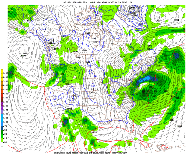
168 HR
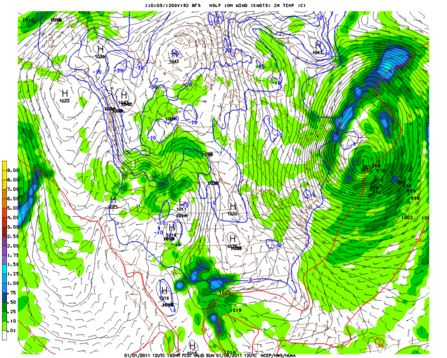
192 HR
Moderator: S2k Moderators
 The posts in this forum are NOT official forecast and should not be used as such. They are just the opinion of the poster and may or may not be backed by sound meteorological data. They are NOT endorsed by any professional institution or STORM2K.


Extremeweatherguy wrote:If today's 12z GFS run is correct, then there may be more freeze threats deep into peninsular Florida by this upcoming weekend..
168 HR
192 HR
HURRICANELONNY wrote:I don't know for sure if the GFS is totally wrong. Last cold invasion the models did something similar. There are signs that the Artic air will be back. Including a -NAO/AO. Have to wait and see what happens mid month. It might come in front after front.
NDG wrote:HURRICANELONNY wrote:I don't know for sure if the GFS is totally wrong. Last cold invasion the models did something similar. There are signs that the Artic air will be back. Including a -NAO/AO. Have to wait and see what happens mid month. It might come in front after front.
Both the NAO & AO have been negative for a while now.
I was talking about what the GFS was forecasting a couple of days ago or so of freezing temps returning to the FL Peninsula this weekend while the Euro was not doing so.
There's no model support for freezing temps to return this weekend for central/S FL.
HURRICANELONNY wrote:NDG wrote:HURRICANELONNY wrote:I don't know for sure if the GFS is totally wrong. Last cold invasion the models did something similar. There are signs that the Artic air will be back. Including a -NAO/AO. Have to wait and see what happens mid month. It might come in front after front.
Both the NAO & AO have been negative for a while now.
I was talking about what the GFS was forecasting a couple of days ago or so of freezing temps returning to the FL Peninsula this weekend while the Euro was not doing so.
There's no model support for freezing temps to return this weekend for central/S FL.
I think the models have the AO/NAO tanking mid month. Don't know for sure. As for this weekend. Cooler. But most likely. No freeze down here. The models are trending cooler. Have to wait and see. How much.
But the latest long range models are showing
a little bit cooler temperatures compare to earlier runs. Will
continue to monitor the trends in the long range models and if the
trend continues then will make adjustments to the weekend temperatures in
later packages.


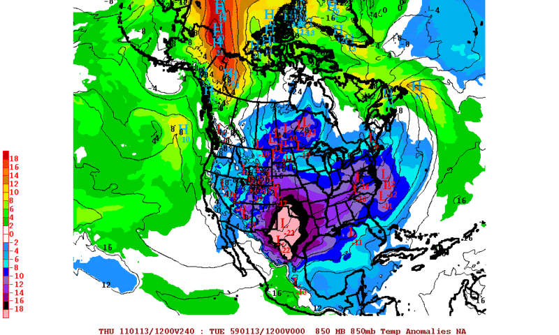
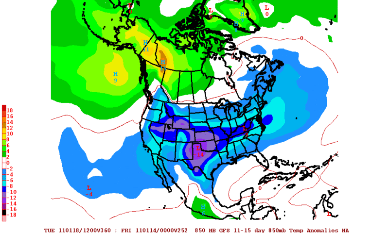
northjaxpro wrote:Longer range runs from the EURO and GFS are indicating major, major changes now as bitterly cold arctic air from Siberia is poised to drop southward down the Lee side of the Rockies into the Eastern 2/3 of the CONUS, icluding the Deep South and Florida.
There are indications that this upcoming arctic intrusion coming within the next 7-10 days could rival the major arctic outbreak of December 1989. This situation is being followed on two other threads. Needless to say, all of my fellow Storm2K posters here in Florida definitely need to closely monitor this situation over the course of the next week. This is a potentially serious situation for sure. This is amazing that this may occur, especially after many of us in the peninsula are just finished still trying to recover from the coldest December ever on record.
STAY TUNED!!!!
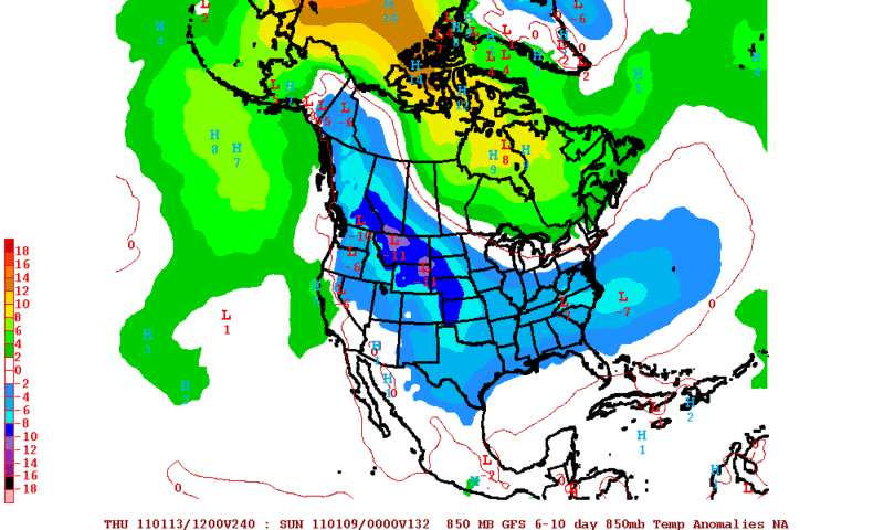
NDG wrote:Still no signs that the FL Peninsula will experience anything as cold as we experienced in December over the next 6-10 days at least.
northjaxpro wrote:NDG wrote:Still no signs that the FL Peninsula will experience anything as cold as we experienced in December over the next 6-10 days at least.
I agree. Going through the next 7 days, most of the peninsula from the I-4 corridor southward should not have to deal with any substantial cold, certainly not to the magnitude of what we had in December. Where I am in NE FL and other interior colder locations of the northern peninsula and panhandle, there will be chances of seeing light freezes (upper 20s-lower 30s) Friday And Saturday morning.
Hopefully the peninsula will be spared this month with no arctic outbreaks. However, I won't feel good about this until we get past the Jan.15-20 period. It is during this period that the model guidance is showing a significant arctic air intrusion coming south down through Plains and TN Valley region. I hope the core of that airmass gets shunted away from the peninsula, but we just will continue to monitor the trends with the models in the days to come.
BTW, I measured just over an inch of rain early this evening. This is the first time I have measured this much rain in a single day since late September 2010. My goodness this rain was so badly needed as we finished 2010 with about a 19 inch rain deficit. We will take it anyway we can get it for sure!
Users browsing this forum: No registered users and 45 guests


