Deep South Winterwx Discussion 2015-2016
Moderator: S2k Moderators
Forum rules
 The posts in this forum are NOT official forecast and should not be used as such. They are just the opinion of the poster and may or may not be backed by sound meteorological data. They are NOT endorsed by any professional institution or STORM2K.
 The posts in this forum are NOT official forecast and should not be used as such. They are just the opinion of the poster and may or may not be backed by sound meteorological data. They are NOT endorsed by any professional institution or STORM2K.
Re: Deep South Winterwx thread: January trouble
Thunder snow in Columbia SC this morning. Amazing!
0 likes
- Tstormwatcher
- S2K Supporter

- Posts: 3086
- Joined: Thu Oct 20, 2005 7:31 pm
- Location: New Bern, NC
Re: Deep South Winterwx thread: January trouble
8" of snow here in Lawrence county - neighboring Giles county reported 13" !
0 likes
-
Brent
- S2K Supporter

- Posts: 38755
- Age: 37
- Joined: Sun May 16, 2004 10:30 pm
- Location: Tulsa Oklahoma
- Contact:
Re: Deep South Winterwx thread: January trouble
My yard right now, that is all sleet, maybe a little freezing rain


0 likes
#neversummer
-
Brent
- S2K Supporter

- Posts: 38755
- Age: 37
- Joined: Sun May 16, 2004 10:30 pm
- Location: Tulsa Oklahoma
- Contact:
Re: Deep South Winterwx thread: January trouble
Can anyone give us an update on the cold that is scheduled to come sometime next week???
0 likes
- MississippiWx
- S2K Supporter

- Posts: 1720
- Joined: Sat Aug 14, 2010 1:44 pm
- Location: Hattiesburg, Mississippi
Re: Deep South Winterwx thread: January trouble
tugreenie wrote:Can anyone give us an update on the cold that is scheduled to come sometime next week???
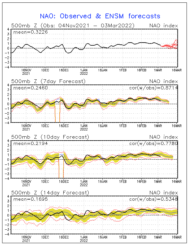
Models are trending much warmer for the coming weeks. One of the main reasons for that is they are predicting the NAO to become neutral if not positive. Looks like the worst of winter should be felt this week across the country before warming up next week. Models, as you know, can change dramatically run to run, but warm is the trend.
0 likes
This post is not an official forecast and should not be used as such. It is just the opinion of MississippiWx and may or may not be backed by sound meteorological data. It is not endorsed by any professional institution including storm2k.org. For Official Information please refer to the NHC and NWS products.
- cycloneye
- Admin

- Posts: 149505
- Age: 69
- Joined: Thu Oct 10, 2002 10:54 am
- Location: San Juan, Puerto Rico
Re: Deep South Winterwx thread: January trouble
Here is the forecast for NAO and as above poster said,neutral to slightly positive at least for the next couple of weeks.


0 likes
Visit the Caribbean-Central America Weather Thread where you can find at first post web cams,radars
and observations from Caribbean basin members Click Here
and observations from Caribbean basin members Click Here
-
Stormcenter
- S2K Supporter

- Posts: 6689
- Joined: Wed Sep 03, 2003 11:27 am
- Location: Houston, TX
Re: Deep South Winterwx thread: January trouble
Not to pick on the models but aren't these the same models who said that
we were suppose to have a really mild Winter in south this season?

we were suppose to have a really mild Winter in south this season?
0 likes
Re: Deep South Winterwx thread: January trouble
for the South??" lol...

0 likes
- carolina_73
- Tropical Storm

- Posts: 148
- Joined: Wed Jul 23, 2008 1:30 am
Re: Deep South Winterwx thread: January trouble
Watching the snow and sleet.. Love the snow dislike the sleet and freezing rain 
0 likes
-
Metalicwx220
- wxman57
- Moderator-Pro Met

- Posts: 23175
- Age: 68
- Joined: Sat Jun 21, 2003 8:06 pm
- Location: Houston, TX (southwest)
Re: Deep South Winterwx thread: January trouble
breeze wrote::darrow: My Joe Bastardi snowman saying, "What happened to my warmer and dryer forecast
for the South??" lol...
http://i558.photobucket.com/albums/ss29 ... nowman.jpg
I always thought of Tennessee as being way up north, coming from south Louisiana. We are hopefully witnessing the last gasp of winter down south. Hopefully... I'm ready for 70s and 80s again.
0 likes
- northjaxpro
- S2K Supporter

- Posts: 8900
- Joined: Mon Sep 27, 2010 11:21 am
- Location: Jacksonville, FL
Hello everyone. I hope everyone who were heavily impacted by the paralyzing winter storm across the Deep South are OK and staying warm and safe.
Yeah, it really has created so many problems across the region. Also, the snow and ice pack in the wake of the storm across the Deep South has really impacted conditions throughout the region. Cold low level cloudiness persists all across the SE US as a strong inversion and weak isentropic downgliding will keep these clouds from breaking up for most of today.
The snow and ice pack is a key reason of course, and because of this, temperatures are going nowhere. Here in north Jax, the temperature has been holding steady at 40 degrees for the past three hours and I don't expect them to warm much more than a couple of more degrees the rest of today. Reached a morning low of 37.6 degrees.
Well, it appears likely that several mornings of freezes are in store for Jax all the way up into Saturday morning, with hard freezes (mid 20s) possible in colder interior NE FL areas Thursday and Friday morning.
Also, it looks like a moderating trend in temps will come by Sunday hopefully as heights rise and we get back to seeing temps back to near seasonable norms by early next week.
0 likes
NEVER, EVER SAY NEVER in the tropics and weather in general, and most importantly, with life itself!!
________________________________________________________________________________________
Fay 2008 Beryl 2012 Debby 2012 Colin 2016 Hermine 2016 Julia 2016 Matthew 2016 Irma 2017 Dorian 2019
________________________________________________________________________________________
Fay 2008 Beryl 2012 Debby 2012 Colin 2016 Hermine 2016 Julia 2016 Matthew 2016 Irma 2017 Dorian 2019
-
CYCLONE MIKE
- Category 5

- Posts: 2183
- Joined: Tue Aug 31, 2004 6:04 pm
- Location: Gonzales, LA
Re: Deep South Winterwx thread: January trouble
And then it could get really cold again. This is from our morning long range forecast...
LONG TERM...
MODELS SHOW A SERIES OF SHORT-WAVE IMPULSES DROPPING INTO A MEAN
TROUGH POSITION ALONG THE MISSISSIPPI VALLEY TO KEEP THE ARCTIC
SURGES DROPPING INTO THE CENTRAL PLAINS AND GULF STATES WELL INTO
NEXT WEEK. THE FREQUENCY OF RESURGENCES ARE ABOUT EVERY THREE DAYS
WITH THE LONGER RANGE GLOBAL MODELS SHOWING EVEN COLDER AIR
ENTERING THE AREA MIDDLE OF NEXT WEEK ALONG SHARP THERMAL TROUGH.
WHILE MUCH OF THIS FORECAST PACKAGE IS PRIMARILY A TEMPERATURE
FORECAST...SOME SENSIBLE WEATHER MAY BE NOTED WITH WARM AIR
ADVECTION SEA FOG DEVELOPMENTS SUNDAY NIGHT AND A RAIN CHANCE
AHEAD OF FRONTAL PASSAGE MONDAY NIGHT. OTHERWISE...MUCH BELOW
NORMAL TEMPERATURES WILL BE THE RULE FOR MUCH OF THE NEXT 7 DAYS
WITH ONLY A BRIEF RESPITE OVER THE WEEKEND. 24/RR
0 likes
Who is online
Users browsing this forum: No registered users and 263 guests


