Winter Weather Discussion
Moderator: S2k Moderators
Forum rules
The posts in this forum are NOT official forecast and should not be used as such. They are just the opinion of the poster and may or may not be backed by sound meteorological data. They are NOT endorsed by any professional institution or
STORM2K.
-
Extremeweatherguy
- Category 5

- Posts: 11095
- Joined: Mon Oct 10, 2005 8:13 pm
- Location: Florida
#281 Postby Extremeweatherguy » Thu Jan 06, 2011 12:41 pm
2010 was a very chilly year across east central Florida. Many locations set new records for most days at or below 60F, and also most number of freezes...
from the MLB NWS
0 likes
-
northjaxpro
- S2K Supporter

- Posts: 8900
- Joined: Mon Sep 27, 2010 11:21 am
- Location: Jacksonville, FL
#283 Postby northjaxpro » Fri Jan 07, 2011 9:00 am
Yes, it does indeed. Also, folks herre in the peninsula will need to closely watch the period from Jan 14-20. This is when a truly very cold arctic air mass will be diving down deep into the CONUS. It is just a question to what magnitude or severity its impact will have on the peninsula when we get to this timeframe.
Keep a close watch on the model guidance trends heading into next week.
0 likes
NEVER, EVER SAY NEVER in the tropics and weather in general, and most importantly, with life itself!!
________________________________________________________________________________________
Fay 2008 Beryl 2012 Debby 2012 Colin 2016 Hermine 2016 Julia 2016 Matthew 2016 Irma 2017 Dorian 2019
-
NDG
- S2K Supporter

- Posts: 15510
- Joined: Sun Jul 09, 2006 10:14 pm
- Location: Orlando, FL
#284 Postby NDG » Fri Jan 07, 2011 1:20 pm
If you look closely the NAO is forecasted to stay slightly positive if not neutral. The AO has been negative for a while and now the gfs ensembles are not showing to dip as negative as they were showing a couple of days ago. I am starting to feel confident that we in central and S FL will not see the worst of this month's arctic intrusion in the US if current trends continue, but way too early yet to let our guards down.
0 likes
-
HURRICANELONNY
- Category 5

- Posts: 1390
- Joined: Wed May 07, 2003 6:48 am
- Location: HOLLYWOOD.FL
#285 Postby HURRICANELONNY » Fri Jan 07, 2011 3:43 pm
NDG wrote:If you look closely the NAO is forecasted to stay slightly positive if not neutral. The AO has been negative for a while and now the gfs ensembles are not showing to dip as negative as they were showing a couple of days ago. I am starting to feel confident that we in central and S FL will not see the worst of this month's arctic intrusion in the US if current trends continue, but way too early yet to let our guards down.
Where can you find the NAO graphs?
0 likes
hurricanelonny
-
NDG
- S2K Supporter

- Posts: 15510
- Joined: Sun Jul 09, 2006 10:14 pm
- Location: Orlando, FL
#286 Postby NDG » Sat Jan 08, 2011 11:52 am
HURRICANELONNY wrote:NDG wrote:If you look closely the NAO is forecasted to stay slightly positive if not neutral. The AO has been negative for a while and now the gfs ensembles are not showing to dip as negative as they were showing a couple of days ago. I am starting to feel confident that we in central and S FL will not see the worst of this month's arctic intrusion in the US if current trends continue, but way too early yet to let our guards down.
Where can you find the NAO graphs?
http://www.cpc.noaa.gov/products/precip/CWlink/pna/nao.shtml
0 likes
-
Patrick99
- Category 5

- Posts: 1774
- Joined: Mon May 24, 2004 3:43 pm
- Location: SW Broward, FL
#287 Postby Patrick99 » Sat Jan 08, 2011 5:16 pm
Why was there such a gusty wind from due west today in S. FL?
0 likes
-
HURRICANELONNY
- Category 5

- Posts: 1390
- Joined: Wed May 07, 2003 6:48 am
- Location: HOLLYWOOD.FL
#288 Postby HURRICANELONNY » Sat Jan 08, 2011 5:19 pm
Patrick99 wrote:Why was there such a gusty wind from due west today in S. FL?
Weak front coming through tonight. Not much change in temps.
0 likes
hurricanelonny
-
Extremeweatherguy
- Category 5

- Posts: 11095
- Joined: Mon Oct 10, 2005 8:13 pm
- Location: Florida
#289 Postby Extremeweatherguy » Mon Jan 10, 2011 12:25 pm
It looks like central FL could be in line for another freeze this week. Below is a look at the 12z NAM and GFS MOS guidance for Orlando (KMCO)...

0 likes
-
NDG
- S2K Supporter

- Posts: 15510
- Joined: Sun Jul 09, 2006 10:14 pm
- Location: Orlando, FL
#290 Postby NDG » Mon Jan 10, 2011 8:04 pm
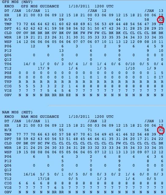
Extremeweatherguy wrote:It looks like central FL could be in line for another freeze this week. Below is a look at the 12z NAM and GFS MOS guidance for Orlando (KMCO)...

Good 'ole cold bias MOS for central FL, as long as it shows 31-32 it means that temps should be 34-35 degs as it usually is a good 3 degrees warmer for actual low temps than what MOS always forecasts.
0 likes
-
Extremeweatherguy
- Category 5

- Posts: 11095
- Joined: Mon Oct 10, 2005 8:13 pm
- Location: Florida
#291 Postby Extremeweatherguy » Tue Jan 11, 2011 7:41 am
Yes, that is usually true. The trend in the MOS guidance has been colder with each run though, and the 6z GFS MOS and 0z NAM MOS both now say 30F for Thursday morning at KMCO. If this cooling trend continues, then another light freeze definitely seems possible for most of central Florida. For now, the NWS is calling for 33F in Orlando, which seems like a good call based on the typical ~3 degree bias you pointed out.
0 likes
-
NDG
- S2K Supporter

- Posts: 15510
- Joined: Sun Jul 09, 2006 10:14 pm
- Location: Orlando, FL
#292 Postby NDG » Tue Jan 11, 2011 8:26 am
Another thing that is good is that winds are forecasted to stay up during the night, so most places will not see frost, which is a bigger killer, & will not see the perfect radiational cooling take effect, not that there is much alive sensitive vegetation left anyway. But this could had been worst if this cold airmass would have had the mid & upper level jet support like it was in December now that there's a nice snow coverage just to our north. 0 deg C isotherm at H85 is not even forecasted to come any further south than Jacksonville, back in Dec at H85 it got down all the way to around -8 deg C here in the Orlando area.
0 likes
-
HURRICANELONNY
- Category 5

- Posts: 1390
- Joined: Wed May 07, 2003 6:48 am
- Location: HOLLYWOOD.FL
#293 Postby HURRICANELONNY » Tue Jan 11, 2011 5:05 pm
A secondary strong cold front over the southeast United States
will also move south down the Florida Peninsula tonight and
through South Florida Wednesday morning. This strong cold front
will allow for a modified Artic airmass to work into the County Warning Area from
the north. The highs on Wednesday will be in the 60s. Lows will be
around freezing over the interior areas around Lake Okeechobee and
inland Collier County...except middle to upper 20s over Glades
County. Rest of the interior areas will see lows in the middle to
upper 30s with the metropolitan areas seeing upper 30s to middle 40s. So at
this time have issued a freeze watch for Glades...Hendry...inland
Palm Beach...and inland Collier County for Wednesday night into
Thursday morning.
0 likes
hurricanelonny
-
psyclone
- S2K Supporter

- Posts: 4804
- Joined: Wed Aug 24, 2005 9:04 pm
- Location: palm harbor fl
#294 Postby psyclone » Tue Jan 11, 2011 5:48 pm
my point and click is down to 30 for wednesday night, lower than i was hoping. freeze watch includes pinellas.
0 likes
-
NDG
- S2K Supporter

- Posts: 15510
- Joined: Sun Jul 09, 2006 10:14 pm
- Location: Orlando, FL
#295 Postby NDG » Tue Jan 11, 2011 8:10 pm
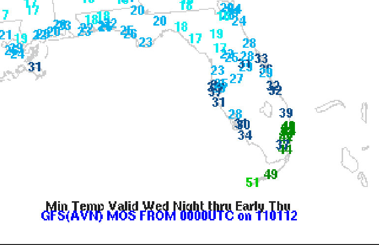
psyclone wrote:my point and click is down to 30 for wednesday night, lower than i was hoping. freeze watch includes pinellas.
Yeap, unlike the 2 Arctic blast back in December, this time the cold air will drain down closer to the west coast of the Peninsula in central FL while the east coast will have the warmer spots, but I doubt that St Pete will get that cold unlike the more inland sections.
0 likes
-
psyclone
- S2K Supporter

- Posts: 4804
- Joined: Wed Aug 24, 2005 9:04 pm
- Location: palm harbor fl
#296 Postby psyclone » Tue Jan 11, 2011 11:38 pm
in general, a rather loose temp gradient is forecast around west central florida, unlike the freeze events back in december. this time temps are projected to range from the mid 20's in the cold spots to the low to mid 30's in warmer locales. not nearly as varied as the cold nights in december when temps ranged from the mid teens to near 40 over the same regions.
0 likes
-
NDG
- S2K Supporter

- Posts: 15510
- Joined: Sun Jul 09, 2006 10:14 pm
- Location: Orlando, FL
#297 Postby NDG » Wed Jan 12, 2011 9:09 am
GFSX MOS forecasted lows for the Orlando area have trended a degree lower once again from last nights 00z run, down to 29 at MCO and to 28 at Sanford, the hope is that they will bust like it was calling for upper 20s for both Ocala & Gainsville this morning. I am thinking low 30s for the immediate city, upper 20s well away from the city for lows. And I doubt that Ocala will see upper teens, IMO.

0 likes
-
psyclone
- S2K Supporter

- Posts: 4804
- Joined: Wed Aug 24, 2005 9:04 pm
- Location: palm harbor fl
#298 Postby psyclone » Wed Jan 12, 2011 2:18 pm
my nws point and click has been dropped to 27 for tonight. should that verify it would be colder than anything we experienced during the december cold blasts.
0 likes
-
NDG
- S2K Supporter

- Posts: 15510
- Joined: Sun Jul 09, 2006 10:14 pm
- Location: Orlando, FL
#299 Postby NDG » Wed Jan 12, 2011 10:11 pm
Current temps across central FL are a good 3-5 degs warmer than what they were forecasted to be by this time, hopefully that's a good sign and many spots across central FL could stay from deeping into the 20s as forecated by our local NWS offices. With winds forecasted to stay up in most spots we will not see the perfect radiational cooling that usually gets us into the 20s, but still too early to tell if forecasted lows will bust or not.
0 likes
-
psyclone
- S2K Supporter

- Posts: 4804
- Joined: Wed Aug 24, 2005 9:04 pm
- Location: palm harbor fl
#300 Postby psyclone » Wed Jan 12, 2011 10:19 pm
I think the hard freeze warning will bust for a good deal of the tampa cwa.
0 likes
Return to “Winter Weather”
Who is online
Users browsing this forum: bevolon, Brandon8181, Brazoria979cnty, bubba hotep, CaptinCrunch, cheezyWXguy, chickypez, cmpcpa99, Cpv17, cstrunk, dfw_toadie, downsouthman1, gboudx, Gotwood, Greener, Harp.1, Iceresistance, iorange55, Ivanhater, JayDT, Longhornmaniac8, orangeblood, Ralph's Weather, rendihess, rwfromkansas, rylo7956, South Texas Storms, Tammie, Texas Snow, texsn95, ThunderSleetDreams, TomballEd, TropicalTundra, utpmg, UTSARoadrunner4, WeatherNewbie, WeatherP1, Winter_Wisher, wxman22 and 385 guests