Texas Winter 2010-2011

Winter Weather Discussion

Moderator: S2k Moderators

Forum rules

The posts in this forum are NOT official forecast and should not be used as such. They are just the opinion of the poster and may or may not be backed by sound meteorological data. They are NOT endorsed by any professional institution or STORM2K.

Help Support Storm2K
Message
Author
User avatar
somethingfunny
ChatStaff
ChatStaff
Posts: 3926
Age: 37
Joined: Thu May 31, 2007 10:30 pm
Location: McKinney, Texas

Re: Texas Winter 2010-2011

#2181 Postby somethingfunny » Fri Jan 14, 2011 7:18 pm

iorange55 wrote:What in the world is with the GFS?

Image


LOL!!! The 18z GFS is always nutty but this might be the best one ever. The 20 degreeC isotherm clearly indicates that's a warm core tropical entity! XD
0 likes   
I am not a meteorologist, and any posts made by me are not official forecasts or to be interpreted as being intelligent. These posts are just my opinions and are probably silly opinions.

User avatar
Longhornmaniac8
Category 1
Category 1
Posts: 254
Joined: Thu Nov 18, 2010 2:30 am
Location: Austin, TX

Re: Texas Winter 2010-2011

#2182 Postby Longhornmaniac8 » Fri Jan 14, 2011 7:46 pm

rkbjunior wrote:If I remember correctly our last ice storm here in Central Texas was around MLK day back in 2007 I think. I remember going to get extra food and drinks and I was able to leave the drinks on the back porch and they were colder sitting out there than if I had put them in the fridge. Hope I get to do that again. :cold:


Woo!!! Yay for Georgetown! I'm a senior at Southwestern!
0 likes   

DonWrk
Category 1
Category 1
Posts: 488
Age: 37
Joined: Mon Jan 03, 2011 11:54 pm
Location: Collinsville, TX

#2183 Postby DonWrk » Fri Jan 14, 2011 7:58 pm

And yet another potential winter event to track! Loved following the first one that came through when it was a good 7 days out, ready to roll with this one.
0 likes   

User avatar
Tireman4
S2K Supporter
S2K Supporter
Posts: 5853
Age: 59
Joined: Fri Jun 30, 2006 1:08 pm
Location: Humble, Texas
Contact:

Re: Texas Winter 2010-2011

#2184 Postby Tireman4 » Fri Jan 14, 2011 9:28 pm

somethingfunny wrote:
iorange55 wrote:What in the world is with the GFS?


LOL!!! The 18z GFS is always nutty but this might be the best one ever. The 20 degreeC isotherm clearly indicates that's a warm core tropical entity! XD


What in the name of all that is Holy? Is this from the Portastorm Weather Center? Did his folks do this? :)
0 likes   

User avatar
Ntxw
Storm2k Moderator
Storm2k Moderator
Posts: 22790
Joined: Wed Oct 21, 2009 6:34 pm
Location: DFW, Texas

Re: Texas Winter 2010-2011

#2185 Postby Ntxw » Fri Jan 14, 2011 10:16 pm

0z updates! NAM is not good beyond 48 hours but does show hints of a low trying to form west of California at hour 84.
0 likes   
The above post and any post by Ntxw is NOT an official forecast and should not be used as such. It is just the opinion of the poster and may or may not be backed by sound meteorological data. It is NOT endorsed by any professional institution including Storm2k. For official information, please refer to NWS products.

  Help support Storm2K!
Help Support Storm2K

User avatar
srainhoutx
S2K Supporter
S2K Supporter
Posts: 6919
Age: 67
Joined: Sun Jan 14, 2007 11:34 am
Location: Haywood County, NC
Contact:

Re: Texas Winter 2010-2011

#2186 Postby srainhoutx » Fri Jan 14, 2011 10:23 pm

Ntxw wrote:0z updates! NAM is not good beyond 48 hours but does show hints of a low trying to form west of California at hour 84.


Perhaps you missed those -39's on the 850's in Canada. Albeit the NAM, that's darn impressive for a mesoscale model at this range, IMO.

Image
0 likes   
Carla/Alicia/Jerry(In The Eye)/Michelle/Charley/Ivan/Dennis/Katrina/Rita/Wilma/Ike/Harvey

Member: National Weather Association
Wx Infinity Forums
http://wxinfinity.com/index.php

Facebook.com/WeatherInfinity
Twitter @WeatherInfinity

User avatar
Ntxw
Storm2k Moderator
Storm2k Moderator
Posts: 22790
Joined: Wed Oct 21, 2009 6:34 pm
Location: DFW, Texas

Re: Texas Winter 2010-2011

#2187 Postby Ntxw » Fri Jan 14, 2011 10:28 pm

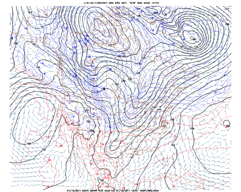
srainhoutx wrote:Perhaps you missed those -39's on the 850's in Canada. Albeit the NAM, that's darn impressive for a mesoscale model at this range, IMO.


I saw that :cheesy: :ggreen:. Just I don't usually look at details beyond the 500mb charts for long range on the NAM or GFS much. Very impressive though!
0 likes   
The above post and any post by Ntxw is NOT an official forecast and should not be used as such. It is just the opinion of the poster and may or may not be backed by sound meteorological data. It is NOT endorsed by any professional institution including Storm2k. For official information, please refer to NWS products.


  Help support Storm2K!

Help Support Storm2K


Bsr
Tropical Wave
Tropical Wave
Posts: 1
Joined: Sat Jan 08, 2011 9:58 pm

Re: Texas Winter 2010-2011

#2188 Postby Bsr » Fri Jan 14, 2011 10:52 pm

Greetings all.

Newcomer to the party. Been a lurker for a while and only decided to post and say thank you. Although I'm a reasonably well-educated man, the language of this site can be difficult to get past....a little like a well intentioned, eager mind reading Shakespeare for the first time, rather than watching it live on stage. In any case, for those rare occurrences when I've actually understood something, or others made it simple for me to understand, thank you. I am quickly becoming a weather...dare I say it...a weather nerd. Not that there is anything wrong with...

You get my point. Thanks again from the idiot who doesn't know a GFS from hole in the head.

Keep up the great work.
0 likes   

User avatar
Ntxw
Storm2k Moderator
Storm2k Moderator
Posts: 22790
Joined: Wed Oct 21, 2009 6:34 pm
Location: DFW, Texas

Re: Texas Winter 2010-2011

#2189 Postby Ntxw » Fri Jan 14, 2011 10:57 pm

Bsr wrote:Greetings all.

Newcomer to the party. Been a lurker for a while and only decided to post and say thank you. Although I'm a reasonably well-educated man, the language of this site can be difficult to get past....a little like a well intentioned, eager mind reading Shakespeare for the first time, rather than watching it live on stage. In any case, for those rare occurrences when I've actually understood something, or others made it simple for me to understand, thank you. I am quickly becoming a weather...dare I say it...a weather nerd. Not that there is anything wrong with...

You get my point. Thanks again from the idiot who doesn't know a GFS from hole in the head.

Keep up the great work.


Welcome aboard! We all start out the same way :P. Feel free to add your input anytime!
0 likes   
The above post and any post by Ntxw is NOT an official forecast and should not be used as such. It is just the opinion of the poster and may or may not be backed by sound meteorological data. It is NOT endorsed by any professional institution including Storm2k. For official information, please refer to NWS products.


  Help support Storm2K!

Help Support Storm2K


User avatar
iorange55
Category 5
Category 5
Posts: 2388
Joined: Thu Nov 13, 2008 9:47 pm
Location: Big D

Re: Texas Winter 2010-2011

#2190 Postby iorange55 » Fri Jan 14, 2011 11:36 pm

Amazing how the GFS is so different than the Euro.

Also according to the GFS we'll basically miss both of the arctic fronts coming down. Somehow they come down to the red river and then just poop east. With basically no precip.

No tropical storm either...pffft talk about flip flopping.
0 likes   

gpsnowman
S2K Supporter
S2K Supporter
Posts: 3190
Joined: Fri Jan 07, 2011 10:35 am
Location: Grand Prairie Tx

#2191 Postby gpsnowman » Fri Jan 14, 2011 11:52 pm

What does IMO mean? Also, I tried to look for and could not find the JB video backtracking his winter outlook. Are some of his videos something you have to pay for? Some are available on the AW site but not all I assume. Hope I don't sound like a dummy but any info would be nice. Alot of winter ahead of us...... :cold:
0 likes   

User avatar
iorange55
Category 5
Category 5
Posts: 2388
Joined: Thu Nov 13, 2008 9:47 pm
Location: Big D

Re:

#2192 Postby iorange55 » Fri Jan 14, 2011 11:53 pm

gpsnowman wrote:What does IMO mean? Also, I tried to look for and could not find the JB video backtracking his winter outlook. Are some of his videos something you have to pay for? Some are available on the AW site but not all I assume. Hope I don't sound like a dummy but any info would be nice. Alot of winter ahead of us...... :cold:


In my opinion.
0 likes   

gpsnowman
S2K Supporter
S2K Supporter
Posts: 3190
Joined: Fri Jan 07, 2011 10:35 am
Location: Grand Prairie Tx

#2193 Postby gpsnowman » Sat Jan 15, 2011 12:07 am

IMO we need a winter storm next week. Had to use it at least once to feel like I am part of the gang.
0 likes   

BigB0882
S2K Supporter
S2K Supporter
Posts: 2284
Joined: Thu Jul 03, 2003 12:08 am
Location: Baton Rouge, LA
Contact:

#2194 Postby BigB0882 » Sat Jan 15, 2011 12:33 am

The GFS must have a relatively strong front coming through in the future. On the 21st our highs look to stay in the 40's. That is as far as this goes out so won't know until tomorrow what it looks like beyond, if it is just a quick event or a longer term one like this last event:

http://68.226.77.253/text/1DegGFS/GFS_Kbtr.txt
0 likes   

User avatar
Ntxw
Storm2k Moderator
Storm2k Moderator
Posts: 22790
Joined: Wed Oct 21, 2009 6:34 pm
Location: DFW, Texas

Re: Texas Winter 2010-2011

#2195 Postby Ntxw » Sat Jan 15, 2011 12:58 am

Canadian suggest next week's cold front might not come through quietly. Beyond that much like the EC/UKMET and unlike the wacky GFS, an amplified western trough, strong cutoff SW storm.

Image
0 likes   
The above post and any post by Ntxw is NOT an official forecast and should not be used as such. It is just the opinion of the poster and may or may not be backed by sound meteorological data. It is NOT endorsed by any professional institution including Storm2k. For official information, please refer to NWS products.


  Help support Storm2K!

Help Support Storm2K


User avatar
Texas2Florida
Tropical Depression
Tropical Depression
Posts: 71
Joined: Thu Dec 03, 2009 12:17 am
Location: NE Pennsylvania backwoods

Re: Texas Winter 2010-2011

#2196 Postby Texas2Florida » Sat Jan 15, 2011 1:49 am

iorange55 wrote:Amazing how the GFS is so different than the Euro.

Also according to the GFS we'll basically miss both of the arctic fronts coming down. Somehow they come down to the red river and then just poop east. With basically no precip.

No tropical storm either...pffft talk about flip flopping.


LOL@ "poop east!" I laughed out loud for 5 minutes. Yeah from what I can see and what I've learned that seems to be what it's showing but kind of illogical..GFS....smh...
0 likes   
Real women wear firesuits! --self proclaimed NASCAR princess.

User avatar
iorange55
Category 5
Category 5
Posts: 2388
Joined: Thu Nov 13, 2008 9:47 pm
Location: Big D

Re: Texas Winter 2010-2011

#2197 Postby iorange55 » Sat Jan 15, 2011 1:50 am

Texas2Florida wrote:
iorange55 wrote:Amazing how the GFS is so different than the Euro.

Also according to the GFS we'll basically miss both of the arctic fronts coming down. Somehow they come down to the red river and then just poop east. With basically no precip.

No tropical storm either...pffft talk about flip flopping.


LOL@ "poop east!" I laughed out loud for 5 minutes. Yeah from what I can see and what I've learned that seems to be what it's showing but kind of illogical..GFS....smh...


hahahahaha. How come no one pointed that out? How awesome.
0 likes   

User avatar
iorange55
Category 5
Category 5
Posts: 2388
Joined: Thu Nov 13, 2008 9:47 pm
Location: Big D

Re: Texas Winter 2010-2011

#2198 Postby iorange55 » Sat Jan 15, 2011 2:11 am

I just glanced at the Euro looks as though it might not be quite as good looking as the past models. Long ways out but it shows some reallllly cold coming down. The main push goes a little east, but even so that is some chilly air it's showing.
0 likes   

User avatar
Ntxw
Storm2k Moderator
Storm2k Moderator
Posts: 22790
Joined: Wed Oct 21, 2009 6:34 pm
Location: DFW, Texas

Re: Texas Winter 2010-2011

#2199 Postby Ntxw » Sat Jan 15, 2011 2:12 am

iorange55 wrote:I just glanced at the Euro looks as though it might not be quite as good looking as the past models. Long ways out but it shows some reallllly cold coming down. The main push goes a little east, but even so that is some chilly air it's showing.


Yeah, it backed off a little from 12z. Still in love with that +PNA! As long as that is intact, we'll eventually get hit by one! Or two! Or three if we're lucky :wink:

Edit:Still not backing off the idea of a winter storm late next week! Still looks like the right pattern for one.
0 likes   
The above post and any post by Ntxw is NOT an official forecast and should not be used as such. It is just the opinion of the poster and may or may not be backed by sound meteorological data. It is NOT endorsed by any professional institution including Storm2k. For official information, please refer to NWS products.


  Help support Storm2K!

Help Support Storm2K


DFW Stormwatcher
Tropical Storm
Tropical Storm
Posts: 240
Age: 54
Joined: Sun Dec 27, 2009 10:35 pm
Location: Keller, Tx

#2200 Postby DFW Stormwatcher » Sat Jan 15, 2011 7:44 am

Fort Worth at least buying in a little to a possible winter storm this coming week:)

000
FXUS64 KFWD 151028
AFDFWD

AREA FORECAST DISCUSSION
NATIONAL WEATHER SERVICE FORT WORTH TX
428 AM CST SAT JAN 15 2011

.DISCUSSION...
AN UPPER LEVEL LOW SOUTH OF EL PASO THIS MORNING...IS DIGGING
SOUTH SOUTHEASTWARD. THIS LOW WILL ROUND THE BOTTOM OF THE TROUGH
TODAY AND MOVE EAST SOUTHEAST ACROSS DEEP SOUTH TEXAS LATE
TONIGHT...AND INTO THE GULF OF MEXICO ON SUNDAY. IN THE
MEANTIME...A SHORTWAVE MOVE SOUTHEAST OUT OF THE ROCKIES ACROSS
TEXAS SUNDAY. WE WILL SEE LIGHT RAIN AND PATCHY FOG AND DRIZZLE
TODAY...WITH THE BEST CHANCES OF MEASURABLE RAIN ACROSS THE
SOUTHEASTERN HALF OF NORTH TEXAS. RAIN CHANCES WILL CONTINUE
TONIGHT THROUGH SUNDAY WITH THE HIGHEST POPS AND QPF ACROSS THE
SOUTHEAST HALF. AS THE UPPER TROUGH MOVE TO THE EAST SUNDAY
NIGHT...RAIN CHANCES WILL END FROM WEST TO EAST. NORTHWESTERLY
FLOW ALOFT WILL PREVAIL EARLY IN THE WEEK. ANOTHER SHORTWAVE WILL
MOVE OUT OF THE ROCKIES ACROSS THE SOUTHERN PLAINS WEDNESDAY
NIGHT AND THURSDAY. THIS SYSTEM WILL BRING AT LEAST A SLIGHT
CHANCE OF RAIN AND COLDER TEMPERATURES. THE 00Z ECMWF SOLUTION IS
WETTER AND COLDER THAN THE 00Z GFS INDICATING THE POTENTIAL FOR
SOME SNOW MAINLY NORTH OF I-20 THURSDAY MORNING
. THE GEM IS ALSO
COLDER THAN THE GFS BUT IS NOT SHOWING MUCH PRECIPITATION. FOR
NOW HAVE JUST MENTIONED LOW RAIN CHANCES AND UNDERCUT THE GFS MOS
HIGHS FOR THURSDAY BY A FEW DEGREES.
0 likes   
Disclaimer: This is not an official weather forecast. I am only an amateur weather enthusiast therefore any weather forecasts or opinions should be taken with a grain of salt. Hook em Horns!


Return to “Winter Weather”

Who is online

Users browsing this forum: No registered users and 3 guests