Winter 2010-11 for the Southern Plains
Moderator: S2k Moderators
Forum rules
 The posts in this forum are NOT official forecast and should not be used as such. They are just the opinion of the poster and may or may not be backed by sound meteorological data. They are NOT endorsed by any professional institution or STORM2K.

The posts in this forum are NOT official forecast and should not be used as such. They are just the opinion of the poster and may or may not be backed by sound meteorological data. They are NOT endorsed by any professional institution or STORM2K.
-
Extremeweatherguy

- Category 5

- Posts: 11095
- Joined: Mon Oct 10, 2005 8:13 pm
- Location: Florida


Re: Winter 2010-11 for the Southern Plains
HPC maps, Wx247 should be ready for it  .
.

0 likes
The above post and any post by Ntxw is NOT an official forecast and should not be used as such. It is just the opinion of the poster and may or may not be backed by sound meteorological data. It is NOT endorsed by any professional institution including Storm2k. For official information, please refer to NWS products.
Help support Storm2K!
-
Extremeweatherguy
- Category 5
- Posts: 11095
- Joined: Mon Oct 10, 2005 8:13 pm
- Location: Florida
00z GFS and NAM precipitation totals for OKC, OUN, and PNC...
(Obtained from: http://www.meteor.iastate.edu/~ckarsten ... index.html)
Oklahoma City:
00z NAM
Rain - 0.00"
Snow - 0.80"
Sleet - 0.01"
Frz rain - 0.00"
00z GFS
Rain - 0.05"
Snow - 1.20"
Sleet - 0.06"
Frz rain - 0.00"
Norman:
00z NAM
Rain - 0.00"
Snow - 0.60"
Sleet - 0.02"
Frz rain - 0.00"
00z GFS
Rain - 0.04"
Snow - 0.50"
Sleet - 0.00"
Frz rain - 0.05"
Ponca City:
00z NAM
Rain - 0.00"
Snow - 3.30"
Sleet - 0.00"
Frz rain - 0.00"
00z GFS
Rain - 0.00"
Snow - 4.30"
Sleet - 0.02"
Frz rain - 0.01"
The trend has definitely been towards higher QPF and thus more winter precipitation with the latest set of runs. It will be interesting to see if this trend continues through tomorrow...
0 likes
-
TwisterFanatic

- Category 5
- Posts: 1041
- Joined: Mon Jun 28, 2010 12:43 pm
- Location: Sallisaw, Oklahoma
CMC on board still also.
0 likes
Personal Forecast Disclaimer:
The posts in this forum are NOT official forecast and should not be used as such. They are just the opinion of the poster and may or may not be backed by sound meteorological data. They are NOT endorsed by any professional institution or storm2k.org. For official information, please refer to the NHC and NWS products.
The posts in this forum are NOT official forecast and should not be used as such. They are just the opinion of the poster and may or may not be backed by sound meteorological data. They are NOT endorsed by any professional institution or storm2k.org. For official information, please refer to the NHC and NWS products.
-
Extremeweatherguy
- Category 5
- Posts: 11095
- Joined: Mon Oct 10, 2005 8:13 pm
- Location: Florida
Re: Winter 2010-11 for the Southern Plains
Not to get ahead of ourselves, but it looks like just beyond the current event, we might be in store for another one by the end of this weekend/early next week.
The 00z ECMWF is showing 0.35" of liquid-equivalent precipitation falling on OKC during this timeframe in an environment favorable for snow. If this scenario proves correct, then we could be looking at a widespread 3-4+ inch snowfall. Something to watch for sure..
Ok, back to the current event for tonight/tomorrow --> the OUN NWS has now issued a winter weather advisory that includes Oklahoma City and Norman...
URGENT - WINTER WEATHER MESSAGE
NATIONAL WEATHER SERVICE NORMAN OK
430 AM CST WED JAN 19 2011
OKZ022>032-039>043-046-047-192200-
/O.NEW.KOUN.WW.Y.0003.110120T0600Z-110120T1900Z/
WASHITA-CADDO-CANADIAN-OKLAHOMA-LINCOLN-GRADY-MCCLAIN-CLEVELAND-
POTTAWATOMIE-SEMINOLE-HUGHES-STEPHENS-GARVIN-MURRAY-PONTOTOC-COAL-
CARTER-JOHNSTON-
INCLUDING THE CITIES OF...CORDELL...ANADARKO...YUKON...EL RENO...
MUSTANG...OKLAHOMA CITY...CHANDLER...CHICKASHA...PURCELL...
NORMAN...MOORE...SHAWNEE...SEMINOLE...HOLDENVILLE...DUNCAN...
PAULS VALLEY...SULPHUR...ADA...COALGATE...ARDMORE...TISHOMINGO
430 AM CST WED JAN 19 2011
...WINTER WEATHER ADVISORY IN EFFECT FROM MIDNIGHT TONIGHT TO
1 PM CST THURSDAY...
THE NATIONAL WEATHER SERVICE IN NORMAN HAS ISSUED A WINTER
WEATHER ADVISORY FOR ICE...SNOW...AND WIND. THE WINTER WEATHER
ADVISORY IS IN EFFECT FROM MIDNIGHT TONIGHT TO 1 PM CST THURSDAY.
* TIMING: LIGHT FREEZING RAIN BEGINNING AFTER MIDNIGHT TONIGHT...
CHANGING TO A MIXTURE OF FREEZING RAIN...SLEET...AND SNOW BY
THURSDAY MORNING. MORE SNOW AND SLEET NORTH TOWARD OKLAHOMA
CITY...AND MORE LIGHT FREEZING RAIN AND SLEET SOUTH TOWARD
ARDMORE.
* MAIN IMPACT: LIGHT GLAZE OF ICE IS POSSIBLE IF NOT LIKELY. THIS
WILL BE FOLLOWED BY LIGHT ACCUMULATION...UP TO ONE INCH...OF
SLEET AND SNOW.
* OTHER IMPACTS: BRISK WINDS AND FALLING TEMPERATURES WILL RESULT
IN WIND CHILL TEMPERATURES AROUND 5 TO 10 DEGREES.
PRECAUTIONARY/PREPAREDNESS ACTIONS...
BE CAREFUL IF YOU HAVE TO TRAVEL. EVEN SMALL AMOUNTS OF ICE AND
SNOW CAN MAKE ROADS AND SIDEWALKS SLICK AND DANGEROUS. IF YOU HAVE
TO BE OUTSIDE...DRESS IN LAYERS AND LEAVE NO SKIN EXPOSED TO THE WIND.
&&
0 likes
-
Extremeweatherguy
- Category 5
- Posts: 11095
- Joined: Mon Oct 10, 2005 8:13 pm
- Location: Florida
06z GFS and NAM precipitation totals for OKC, OUN, and PNC...
(Obtained from: http://www.meteor.iastate.edu/~ckarsten ... index.html)
Oklahoma City:
06z NAM
Rain - 0.00"
Snow - 0.80"
Sleet - 0.01"
Frz rain - 0.00"
06z GFS
Rain - 0.05"
Snow - 1.60"
Sleet - 0.10"
Frz rain - 0.00"
Norman:
06z NAM
Rain - 0.00"
Snow - 0.60"
Sleet - 0.01"
Frz rain - 0.00"
06z GFS
Rain - 0.02-0.03"
Snow - 1.50"
Sleet - 0.00"
Frz rain - 0.07"
Ponca City:
06z NAM
Rain - 0.00"
Snow - 3.50"
Sleet - 0.00"
Frz rain - 0.00"
06z GFS
Rain - 0.00"
Snow - 6.70"
Sleet - 0.00"
Frz rain - 0.00"
The upward trend continues! The latest GFS is showing nearly 7 inches of snow in Ponca City and close to 2 inches in Oklahoma City! That is a 3.0+ inch increase for Ponca City since yesterday's 18z run and a 0.7+ inch increase for Oklahoma City.
0 likes
-
srainhoutx

- S2K Supporter

- Posts: 6919
- Age: 68
- Joined: Sun Jan 14, 2007 11:34 am
- Location: Haywood County, NC
- Contact:
Re: Winter 2010-11 for the Southern Plains
The radar trends suggest things may well be progressing a bit faster than expected across E KS/N and NE OK.
0 likes
Carla/Alicia/Jerry(In The Eye)/Michelle/Charley/Ivan/Dennis/Katrina/Rita/Wilma/Ike/Harvey
Member: National Weather Association
Wx Infinity Forums
http://wxinfinity.com/index.php
Facebook.com/WeatherInfinity
Twitter @WeatherInfinity
Member: National Weather Association
Wx Infinity Forums
http://wxinfinity.com/index.php
Facebook.com/WeatherInfinity
Twitter @WeatherInfinity
-
Extremeweatherguy
- Category 5
- Posts: 11095
- Joined: Mon Oct 10, 2005 8:13 pm
- Location: Florida
Re: Winter 2010-11 for the Southern Plains
Long duration, but relatively light, winter event setting up for next week if the 12z ECMWF is correct. It is showing light precipitation falling in OKC between Sunday morning and Tuesday morning, with profiles looking favorable for snow. Only about 0.25-0.30" total QPF during this period though, which means accumulations probably wouldn't be too extreme. It is also showing surface temperatures a bit on the warmish side (though the upper levels look great), so that will be something to monitor closely.
As for tonight's event, the models continue to look more and more favorable. Based on the latest runs, I think it is reasonable to believe that 0.5-2" of snow will be commonplace across the OKC region tonight/tomorrow (NAM shows 0.8" snow in OKC, GFS shows 1.7" snow in OKC). A few spots could even see slightly more if a couple heavier bands manage to set up.
As for tonight's event, the models continue to look more and more favorable. Based on the latest runs, I think it is reasonable to believe that 0.5-2" of snow will be commonplace across the OKC region tonight/tomorrow (NAM shows 0.8" snow in OKC, GFS shows 1.7" snow in OKC). A few spots could even see slightly more if a couple heavier bands manage to set up.
0 likes
-
TwisterFanatic
- Category 5
- Posts: 1041
- Joined: Mon Jun 28, 2010 12:43 pm
- Location: Sallisaw, Oklahoma
Better hunker down. 3-5 inches coming overnight. 
0 likes
Personal Forecast Disclaimer:
The posts in this forum are NOT official forecast and should not be used as such. They are just the opinion of the poster and may or may not be backed by sound meteorological data. They are NOT endorsed by any professional institution or storm2k.org. For official information, please refer to the NHC and NWS products.
The posts in this forum are NOT official forecast and should not be used as such. They are just the opinion of the poster and may or may not be backed by sound meteorological data. They are NOT endorsed by any professional institution or storm2k.org. For official information, please refer to the NHC and NWS products.
-
Extremeweatherguy
- Category 5
- Posts: 11095
- Joined: Mon Oct 10, 2005 8:13 pm
- Location: Florida
-
Extremeweatherguy
- Category 5
- Posts: 11095
- Joined: Mon Oct 10, 2005 8:13 pm
- Location: Florida
Re: Winter 2010-11 for the Southern Plains
One last look at the latest model accumulation output before the event gets underway...
(Obtained from: http://www.meteor.iastate.edu/~ckarsten ... index.html)
Oklahoma City:
18z NAM
Rain - 0.00"
Snow - 1.90"
Sleet - 0.00"
Frz rain - 0.00"
18z GFS
Rain - 0.07"
Snow - 0.70"
Sleet - 0.09"
Frz rain - 0.00"
Norman:
18z NAM
Rain - 0.00"
Snow - 1.50"
Sleet - 0.00"
Frz rain - 0.00"
18z GFS
Rain - 0.05"
Snow - 1.00"
Sleet - 0.00"
Frz rain - 0.05"
Ponca City:
18z NAM
Rain - 0.00"
Snow - 2.40"
Sleet - 0.00"
Frz rain - 0.00"
18z GFS
Rain - 0.00"
Snow - 8.20"
Sleet - 0.00"
Frz rain - 0.00"
0 likes
-
BlueIce
- S2K Supporter
- Posts: 194
- Age: 37
- Joined: Mon Sep 01, 2008 10:05 pm
- Location: Oklahoma City, Oklahoma
Re: Winter 2010-11 for the Southern Plains
I like the current trends. Hopefully we will get a decent amount of snow in the city tomorrow.
Check out Ponca City with 8.2" of snow thats crazy.
Check out Ponca City with 8.2" of snow thats crazy.
0 likes
-
TwisterFanatic
- Category 5
- Posts: 1041
- Joined: Mon Jun 28, 2010 12:43 pm
- Location: Sallisaw, Oklahoma
Re: Winter 2010-11 for the Southern Plains
BlueIce wrote:I like the current trends. Hopefully we will get a decent amount of snow in the city tomorrow.
Check out Ponca City with 8.2" of snow thats crazy.
Yea, its crazy. Yesterday i was supposed to get flurries to maybe a dusting, and 24 hours later i am looking at 4-7 inches.
0 likes
Personal Forecast Disclaimer:
The posts in this forum are NOT official forecast and should not be used as such. They are just the opinion of the poster and may or may not be backed by sound meteorological data. They are NOT endorsed by any professional institution or storm2k.org. For official information, please refer to the NHC and NWS products.
The posts in this forum are NOT official forecast and should not be used as such. They are just the opinion of the poster and may or may not be backed by sound meteorological data. They are NOT endorsed by any professional institution or storm2k.org. For official information, please refer to the NHC and NWS products.

-
srainhoutx
- S2K Supporter
- Posts: 6919
- Age: 68
- Joined: Sun Jan 14, 2007 11:34 am
- Location: Haywood County, NC
- Contact:
Re: Winter 2010-11 for the Southern Plains
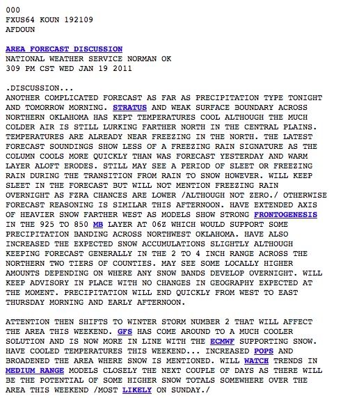
AREA FORECAST DISCUSSION
NATIONAL WEATHER SERVICE NORMAN OK
1004 PM CST WED JAN 19 2011
.UPDATE...
HRRR MODEL HAS BEEN CONSISTENT IN LAYING OUT A RELATIVELY NARROW
BAND OF HEAVIER SNOW ACCUMULATIONS W TO E ACROSS N OK OVERNIGHT
INTO THU MORNING. RUNS PRIOR TO 00Z HELD THIS BAND IN PLACE FROM
JUST S OF GAG AND ENID TO NEAR AND JUST N OF SWO... WITH MAX
ACCUMULATIONS LOCALLY OVER 4 INCHES AND OCCASIONALY NEAR 8 AROUND
PERRY. LAST COUPLE RUNS HAVE BACKED OFF A BIT ON AMOUNTS AND HAVE
SHIFTED THE AXIS OF HEAVIER SNOW SLIGHTLY SOUTH. 01Z RUN HAS IT A
LITTLE N OF I-40. NOT SURE WHAT TO MAKE OF THIS OR WHETHER TO
BELIEVE IT AT ALL... BUT RECENT RUC13 RUNS SHOW SIMILAR TRENDS AND
A STRIPE OF MOSTLY 1-3 INCHES JUST N OF I-40. NAM12 ALSO HAS A
HEAVIER BAND BUT IS FARTHER N. ONSET OF PRECIP IN NW OK AND LATEST
RADAR TRENDS OF INTENSIFYING ECHOES IN A NARROW BAND MAY BE THE
FIRST SIGN. SEEMS A GOOD CHANCE THERE WILL BE A NARROW BAND OF
ENHANCED SNOWFALL SOMEWHERE NORTH OF I-40... BUT WITH
UNCERTAINTIES ON THE PRECISE LOCATION WE WILL NOT GET TOO FANCY
YET AND KEEP THE ADVISORY AS IS.
SOME ADJUSTMENTS HAVE BEEN MADE TO T AND WIND GRIDS OVERNIGHT TO
BETTER REFLECT THE COLD FRONT NOW MOVING INTO S OK AND NCENTRAL
TX.
0 likes
Carla/Alicia/Jerry(In The Eye)/Michelle/Charley/Ivan/Dennis/Katrina/Rita/Wilma/Ike/Harvey
Member: National Weather Association
Wx Infinity Forums
http://wxinfinity.com/index.php
Facebook.com/WeatherInfinity
Twitter @WeatherInfinity
Member: National Weather Association
Wx Infinity Forums
http://wxinfinity.com/index.php
Facebook.com/WeatherInfinity
Twitter @WeatherInfinity
Re: Winter 2010-11 for the Southern Plains
Some moderate to heavy snow bands are appearing just north and east of OKC. Enid and Tulsa both are about to be under them with visibilities likely dropping near 1 mile or less!

0 likes
The above post and any post by Ntxw is NOT an official forecast and should not be used as such. It is just the opinion of the poster and may or may not be backed by sound meteorological data. It is NOT endorsed by any professional institution including Storm2k. For official information, please refer to NWS products.
Help support Storm2K!
Help support Storm2K!
-
Extremeweatherguy
- Category 5
- Posts: 11095
- Joined: Mon Oct 10, 2005 8:13 pm
- Location: Florida
-
Extremeweatherguy
- Category 5
- Posts: 11095
- Joined: Mon Oct 10, 2005 8:13 pm
- Location: Florida
-
Extremeweatherguy
- Category 5
- Posts: 11095
- Joined: Mon Oct 10, 2005 8:13 pm
- Location: Florida
-
Extremeweatherguy
- Category 5
- Posts: 11095
- Joined: Mon Oct 10, 2005 8:13 pm
- Location: Florida
I wound up with about a half inch of powdery, blowing snow on top of a layer of ice. Not bad, but I would have preferred there have been no ice and all snow, since the roads were very slick this morning and led to several accidents.
As for the second system that we were watching for the end of this weekend/early next week, the latest model trends are not all that great. Most models are now showing very little if any precipitation across the region. There is still time for a reversal in these trends of course, but as of now it does not look too promising for those wanting something equal to or more significant than today's event.
As for the second system that we were watching for the end of this weekend/early next week, the latest model trends are not all that great. Most models are now showing very little if any precipitation across the region. There is still time for a reversal in these trends of course, but as of now it does not look too promising for those wanting something equal to or more significant than today's event.
0 likes
Who is online
Users browsing this forum: No registered users and 156 guests