Winter 2010-11 for the Southern Plains
Moderator: S2k Moderators
Forum rules
 The posts in this forum are NOT official forecast and should not be used as such. They are just the opinion of the poster and may or may not be backed by sound meteorological data. They are NOT endorsed by any professional institution or STORM2K.

The posts in this forum are NOT official forecast and should not be used as such. They are just the opinion of the poster and may or may not be backed by sound meteorological data. They are NOT endorsed by any professional institution or STORM2K.
-
TwisterFanatic

- Category 5

- Posts: 1041
- Joined: Mon Jun 28, 2010 12:43 pm
- Location: Sallisaw, Oklahoma
Snow totals here were hindered by a prolonged period of freezing rain. Ended up with .25 Freezing Rain, 3.2 inches of snow.
0 likes
Personal Forecast Disclaimer:
The posts in this forum are NOT official forecast and should not be used as such. They are just the opinion of the poster and may or may not be backed by sound meteorological data. They are NOT endorsed by any professional institution or storm2k.org. For official information, please refer to the NHC and NWS products.
The posts in this forum are NOT official forecast and should not be used as such. They are just the opinion of the poster and may or may not be backed by sound meteorological data. They are NOT endorsed by any professional institution or storm2k.org. For official information, please refer to the NHC and NWS products.
-
wx247

- S2K Supporter

- Posts: 14279
- Age: 42
- Joined: Wed Feb 05, 2003 10:35 pm
- Location: Monett, Missouri
- Contact:
I received 4.25" of snow! Snow day... woot woot! 
0 likes
Personal Forecast Disclaimer:
The posts in this forum are NOT official forecast and should not be used as such. They are just the opinion of the poster and may or may not be backed by sound meteorological data. They are NOT endorsed by any professional institution or storm2k.org. For official information, please refer to the NHC and NWS products.
The posts in this forum are NOT official forecast and should not be used as such. They are just the opinion of the poster and may or may not be backed by sound meteorological data. They are NOT endorsed by any professional institution or storm2k.org. For official information, please refer to the NHC and NWS products.

-
Extremeweatherguy

- Category 5
- Posts: 11095
- Joined: Mon Oct 10, 2005 8:13 pm
- Location: Florida
Yeah, it definitely looks like we will be entering a very interesting pattern starting about a week from now if the latest model trends are correct. The potential is definitely there for a significant winter event (either in terms of cold, winter precipitation, or both).
In the shorter term, I am starting to get interested in the idea that there might be a minor snow event across the region Monday night into Tuesday morning. It doesn't look like a big deal right now, and would probably only amount to a dusting, but the signals are definitely becoming more pronounced for light precipitation with each model run.
The general scenario right now is a band of light precipitation forming in NW Oklahoma during Monday evening, and then progressing SE across the state (and into parts of TX) during the overnight hours. The band is relatively thin, and would probably only lead to a quick period of snow showers with light accumulations, but it would definitely be a surprise for many considering snow is currently not in the forecast during that timeframe.
Below are some of the latest model depictions of this possible Mon. night/Tues. morning minor event:
NAM
The simulated composite reflectivity below illustrates the idea of a NW to SE moving band of light precipitation quite well:
http://www.twisterdata.com/data/models/ ... URFACE.png
http://www.twisterdata.com/data/models/ ... URFACE.png
http://www.twisterdata.com/data/models/ ... URFACE.png
http://www.twisterdata.com/data/models/ ... URFACE.png
Only very light QPF values though:
http://www.twisterdata.com/data/models/ ... _18_HR.png
GFS
The GFS is the least bullish of the models right now, showing only a little bit of light precipitation near/just south of the Oklahoma-Texas border.
http://www.nco.ncep.noaa.gov/pmb/nwprod ... p_054l.gif
CMC
The CMC is showing a nice little band of light (0.01-0.10" QPF values) sweeping across Oklahoma. Overall, it is fairly similar to the NAM.
http://www.meteo.psu.edu/~gadomski/CMC_0zA/f54.gif
http://www.meteo.psu.edu/~gadomski/CMC_0zA/f60.gif
ECMWF
Using my accuweather pro account, I can also confirm that the ECMWF is buying into this idea as well; showing pockets of light QPF popping up across the region during the mentioned timeframe.
UPDATE (1/23/11 10:27am): The 12z model runs today are not looking quite as good. They still show some light precipitation, however it appears that they are keeping most of it more towards western Oklahoma and western north Texas. The NWS discussion is also not too excited, saying the possibility is there, but that the atmosphere might be too dry to get anything to the ground. Still something to keep an eye on though..
UPDATE 2 (1/23/11 12:15pm): Well it looks like I might have spoken too soon. The CMC and ECMWF still look very interesting for Monday night into Tuesday, showing a decent potential for snow flurries/light snow showers depending on surface temperatures at the time.
UPDATE 3 (1/24/11 6:50pm): It looks like this will be mostly a non-event. A small patch of winter weather advisories has been issued near Abilene for accumulations up to an inch. Might also see some flurries extend into SW Oklahoma overnight (20% chance), with a very slight chance of a couple flurries further north and east into OKC and DFW (<20% chance), but most people shouldn't see much at all. Looks like its time to start focusing on the next event that looks could be here in a 6-8 days or so if the modeling holds up..
0 likes

Re: Winter 2010-11 for the Southern Plains
The gfs at 192 till about 240 looks interesting. What does the Euro think?
0 likes
Re: Winter 2010-11 for the Southern Plains
0z gfs still pimpin some snow for the Texas panhandle and OK but not as much moisture as last run 
0 likes
-
Extremeweatherguy
- Category 5
- Posts: 11095
- Joined: Mon Oct 10, 2005 8:13 pm
- Location: Florida
Re: Winter 2010-11 for the Southern Plains
There is some mighty cold air on the way next week if tonight's 00z ECMWF proves correct.
It is showing the -20C 850mb isotherm extending into northern Oklahoma by hour 168 with an almost 1050mb high pushing down the plains:
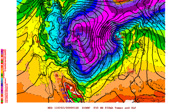
It is showing the -20C 850mb isotherm extending into northern Oklahoma by hour 168 with an almost 1050mb high pushing down the plains:
0 likes
-
Extremeweatherguy
- Category 5
- Posts: 11095
- Joined: Mon Oct 10, 2005 8:13 pm
- Location: Florida
The 18z GFS is insane. It is showing 12+ inches of snow on the ground across a good chunk of central Oklahoma next Wednesday morning:
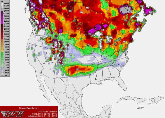
This is the first run to show such crazy amounts, and we are still a little too far out to take this seriously; but it is interesting to see none the less. It is definitely not every day that you see the models showing a 12 inch+ snowstorm across this region.
This is the first run to show such crazy amounts, and we are still a little too far out to take this seriously; but it is interesting to see none the less. It is definitely not every day that you see the models showing a 12 inch+ snowstorm across this region.
0 likes
-
TwisterFanatic
- Category 5
- Posts: 1041
- Joined: Mon Jun 28, 2010 12:43 pm
- Location: Sallisaw, Oklahoma
18z made me slobber. 
0 likes
Personal Forecast Disclaimer:
The posts in this forum are NOT official forecast and should not be used as such. They are just the opinion of the poster and may or may not be backed by sound meteorological data. They are NOT endorsed by any professional institution or storm2k.org. For official information, please refer to the NHC and NWS products.
The posts in this forum are NOT official forecast and should not be used as such. They are just the opinion of the poster and may or may not be backed by sound meteorological data. They are NOT endorsed by any professional institution or storm2k.org. For official information, please refer to the NHC and NWS products.
Re: Winter 2010-11 for the Southern Plains
The 18 gfs is dropping about 12 inches at my house. What surface temperature is the euro showing in the same time frame?
0 likes
-
BlueIce
- S2K Supporter
- Posts: 194
- Age: 37
- Joined: Mon Sep 01, 2008 10:05 pm
- Location: Oklahoma City, Oklahoma
Re: Winter 2010-11 for the Southern Plains
The 0z run is looking fun... Tuesday the start of a winter storm in Oklahoma?
Cold Air

+ Gulf Moisture

=Possible Winter Storm?

Cold Air

+ Gulf Moisture

=Possible Winter Storm?

0 likes
-
TwisterFanatic
- Category 5
- Posts: 1041
- Joined: Mon Jun 28, 2010 12:43 pm
- Location: Sallisaw, Oklahoma
Yea, a good trend is starting. Hope it holds. Haven't had a real good snow here in Oklahoma this year yet.
0 likes
Personal Forecast Disclaimer:
The posts in this forum are NOT official forecast and should not be used as such. They are just the opinion of the poster and may or may not be backed by sound meteorological data. They are NOT endorsed by any professional institution or storm2k.org. For official information, please refer to the NHC and NWS products.
The posts in this forum are NOT official forecast and should not be used as such. They are just the opinion of the poster and may or may not be backed by sound meteorological data. They are NOT endorsed by any professional institution or storm2k.org. For official information, please refer to the NHC and NWS products.
-
Extremeweatherguy
- Category 5
- Posts: 11095
- Joined: Mon Oct 10, 2005 8:13 pm
- Location: Florida
Behind the winter storm threat, it looks like we could be dealing with some serious cold next week (depending on which model scenario proves correct).
The 00z GFS text output has Oklahoma City getting down to 0F at 6pm on February 2nd (http://www.meteor.iastate.edu/~ckarsten ... &site=kokc), and if the CMC scenario is correct, then it might even get colder than that.
Needless to say, that magnitude of cold (near/below 0F) is pretty unusual down here, and would certainly be in the "extreme" category. This potential will need to watched closely..
0 likes
-
BlueIce
- S2K Supporter
- Posts: 194
- Age: 37
- Joined: Mon Sep 01, 2008 10:05 pm
- Location: Oklahoma City, Oklahoma
Re: Winter 2010-11 for the Southern Plains
The 12z GFS run is still showing a decent amount of snow accumulation. Are the other models hinting towards this or are we only getting snow from one model at this point?
0 likes

Re: Winter 2010-11 for the Southern Plains
BlueIce wrote:The 12z GFS run is still showing a decent amount of snow accumulation. Are the other models hinting towards this or are we only getting snow from one model at this point?
Oklahoma is getting snow on just about every model.
0 likes
-
Extremeweatherguy
- Category 5
- Posts: 11095
- Joined: Mon Oct 10, 2005 8:13 pm
- Location: Florida
Re: Winter 2010-11 for the Southern Plains
18z GFS snowfall accumulation at hour 138...
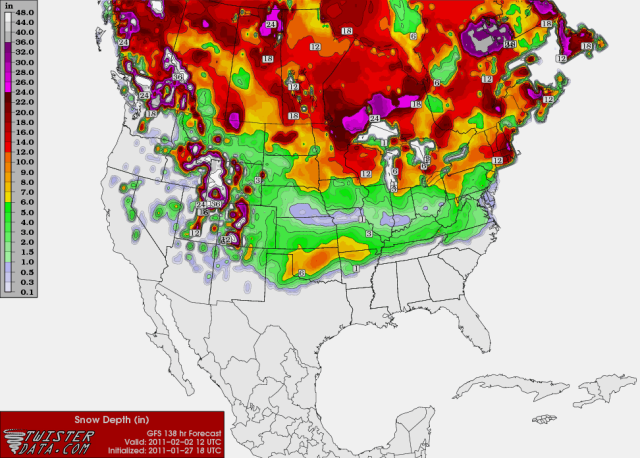
No widespread 12+ inch amounts on this run, but still a very significant storm for the region. Most of the state is in the 6+ inch zone, with a good chunk of central Oklahoma in the 8-12 inch zone.
It also continues to look very cold once the snow winds down. This run is showing the temperature falling to -3.8F in OKC next Wednesday night, which would be the coldest temperature the city has experienced since February 1996 if it verified.
0 likes
-
TwisterFanatic
- Category 5
- Posts: 1041
- Joined: Mon Jun 28, 2010 12:43 pm
- Location: Sallisaw, Oklahoma
Yea, every Pro-Met around here is calling for a possible Significant Winter Storm. Just hope its not an Ice Storm.
0 likes
Personal Forecast Disclaimer:
The posts in this forum are NOT official forecast and should not be used as such. They are just the opinion of the poster and may or may not be backed by sound meteorological data. They are NOT endorsed by any professional institution or storm2k.org. For official information, please refer to the NHC and NWS products.
The posts in this forum are NOT official forecast and should not be used as such. They are just the opinion of the poster and may or may not be backed by sound meteorological data. They are NOT endorsed by any professional institution or storm2k.org. For official information, please refer to the NHC and NWS products.
-
BlueIce
- S2K Supporter
- Posts: 194
- Age: 37
- Joined: Mon Sep 01, 2008 10:05 pm
- Location: Oklahoma City, Oklahoma
Re: Winter 2010-11 for the Southern Plains
I know its early to talk about realistic accumulations. But I think its time to break out the snow man emoticon. 


0 likes
-
Extremeweatherguy
- Category 5
- Posts: 11095
- Joined: Mon Oct 10, 2005 8:13 pm
- Location: Florida
The 00z GFS keeps the big snow totals a little bit more towards NW Oklahoma, with an ice storm setup (frz rain/sleet) over central Oklahoma, transitioning to snow towards the end.
The GFS might be having some issues with the cold air extent though, so i'm not so sure I believe this scenario. It is possible sure; but I think that the cold air at all levels might be further south than depicted (as seen in the 18z and 12z run, and perhaps even further south than that). If i'm wrong though, then this GFS scenario would be nasty! Ice storms are not fun.
Nitpicking the specifics is still a little pointless at this point though, and probably shouldn't be considered seriously until we are within the 72-84 hour timeframe. For now, the main overall idea to take away from the 00z run tonight is that the moisture and cold air are still in place for another consecutive run, and the potential for a winter storm (ice, snow or both) is growing.
0 likes
-
TwisterFanatic
- Category 5
- Posts: 1041
- Joined: Mon Jun 28, 2010 12:43 pm
- Location: Sallisaw, Oklahoma
Looking at the GFS something just doesn't look right with the cold air. Looks to be its the typical GFS error with a Arctic Airmass.
0 likes
Personal Forecast Disclaimer:
The posts in this forum are NOT official forecast and should not be used as such. They are just the opinion of the poster and may or may not be backed by sound meteorological data. They are NOT endorsed by any professional institution or storm2k.org. For official information, please refer to the NHC and NWS products.
The posts in this forum are NOT official forecast and should not be used as such. They are just the opinion of the poster and may or may not be backed by sound meteorological data. They are NOT endorsed by any professional institution or storm2k.org. For official information, please refer to the NHC and NWS products.
Who is online
Users browsing this forum: No registered users and 144 guests