URGENT - WINTER WEATHER MESSAGE
NATIONAL WEATHER SERVICE TULSA OK
353 PM CST SAT JAN 29 2011
ARZ001-002-010-011-OKZ054>070-301100-
/O.NEW.KTSA.WS.A.0002.110201T0000Z-110202T1300Z/
BENTON-CARROLL-WASHINGTON AR-MADISON-OSAGE-WASHINGTON OK-NOWATA-
CRAIG-OTTAWA-PAWNEE-TULSA-ROGERS-MAYES-DELAWARE-CREEK-OKFUSKEE-
OKMULGEE-WAGONER-CHEROKEE-ADAIR-MUSKOGEE-
353 PM CST SAT JAN 29 2011
...WINTER STORM WATCH IN EFFECT FROM MONDAY EVENING THROUGH
WEDNESDAY MORNING...
THE NATIONAL WEATHER SERVICE IN TULSA HAS ISSUED A WINTER STORM
WATCH...WHICH IS IN EFFECT FROM MONDAY EVENING THROUGH WEDNESDAY
MORNING...
FOR THE FOLLOWING COUNTIES...
* IN OKLAHOMA...WASHINGTON...WAGONER...OTTAWA...PAWNEE...
DELAWARE...CHEROKEE...ADAIR...CRAIG...NOWATA...CREEK...
OKFUSKEE...OKMULGEE...MUSKOGEE...TULSA...ROGERS...MAYES AND
OSAGE. IN ARKANSAS...BENTON...WASHINGTON...CARROLL AND MADISON.
HAZARDOUS WEATHER...
* A STRONG WINTER STORM SYSTEM WILL BEGIN TO IMPACT NORTHEAST
OKLAHOMA AND NORTHWEST ARKANSAS MONDAY NIGHT...AND CONTINUE
THROUGH TUESDAY. THE EXACT TRACK OF THIS SYSTEM AND ASSOCIATED
WINTER WEATHER IMPACTS WILL CHANGE IN LATER FORECASTS...YET NOW
IS THE TIME TO PREPARE FOR THIS POTENTIAL STORM.
* SNOW AND SLEET TOTALS FROM 4 TO 10 INCHES...WITH LOCALLY HEAVIER
AMOUNTS...ARE POSSIBLE NORTH OF INTERSTATE 40. ADDITIONALLY...ICE
ACCUMULATIONS AROUND ONE QUARTER INCH ARE POSSIBLE WITH THE HEAVIER
ICING EXPECTED OVER NORTHWEST ARKANSAS.
IMPACTS...
* ROADS...BRIDGES...AND OVERPASSES MAY BECOME SLICK AND HAZARDOUS
IN THE WATCH AREA...MAKING TRAVEL TREACHEROUS. POWER OUTAGES ARE
POSSIBLE.
* EXTREMELY COLD TEMPERATURES WILL FOLLOW THIS STORM SYSTEM. ANY
PROLONGED POWER OUTAGES WOULD QUICKLY ESCALATE INTO A SHELTERING
RESPONSE.
DEFINITION...
* A WINTER STORM WATCH MEANS HEAVY SNOW OR A SIGNIFICANT
ACCUMULATION OF ICE OR SLEET IS EXPECTED IN THE WATCH AREA
DURING THE NEXT 24 TO 36 HOURS.
Winter 2010-11 for the Southern Plains
Moderator: S2k Moderators
Forum rules
 The posts in this forum are NOT official forecast and should not be used as such. They are just the opinion of the poster and may or may not be backed by sound meteorological data. They are NOT endorsed by any professional institution or STORM2K.

The posts in this forum are NOT official forecast and should not be used as such. They are just the opinion of the poster and may or may not be backed by sound meteorological data. They are NOT endorsed by any professional institution or STORM2K.
-
BlueIce
- S2K Supporter

- Posts: 194
- Age: 37
- Joined: Mon Sep 01, 2008 10:05 pm
- Location: Oklahoma City, Oklahoma
Re: Winter 2010-11 for the Southern Plains
Well the first watch went up earlier for this event. It will be interesting to see what tomorrow brings on the models.
0 likes
-
Extremeweatherguy

- Category 5

- Posts: 11095
- Joined: Mon Oct 10, 2005 8:13 pm
- Location: Florida
Each MOS run continues to trend colder and colder. Tonight's 00z GFS MOS is impressive for sure.
On Wednesday, it is now showing a high temperature of just 8F in Tulsa and 11F in Oklahoma City!
On Wednesday, it is now showing a high temperature of just 8F in Tulsa and 11F in Oklahoma City!
Last edited by Extremeweatherguy on Sun Jan 30, 2011 12:36 am, edited 1 time in total.
0 likes
-
Extremeweatherguy
- Category 5
- Posts: 11095
- Joined: Mon Oct 10, 2005 8:13 pm
- Location: Florida
Re: Re:
Metalicwx220 wrote:Extremeweatherguy wrote:Each MOS run continues to trend colder and colder. Tonight's 00z GFS MOS impressive for sure.
On Wednesday, it is now showing a high temperature of just 8F in Tulsa and 11F in Oklahoma City!
IS THAT A RECORD?
For February 2nd, the record coldest high for Oklahoma City is 10F and in Tulsa it is 16F, so for OKC it would be close and for Tulsa it would break the daily record by a good margin.
The all-time record cold high for both cities is 2F though, so that record would remain safe.
0 likes
-
TwisterFanatic

- Category 5
- Posts: 1041
- Joined: Mon Jun 28, 2010 12:43 pm
- Location: Sallisaw, Oklahoma
Re:
Extremeweatherguy wrote:Each MOS run continues to trend colder and colder. Tonight's 00z GFS MOS impressive for sure.
On Wednesday, it is now showing a high temperature of just 8F in Tulsa and 11F in Oklahoma City!
That is just absolutely absurd
0 likes
Personal Forecast Disclaimer:
The posts in this forum are NOT official forecast and should not be used as such. They are just the opinion of the poster and may or may not be backed by sound meteorological data. They are NOT endorsed by any professional institution or storm2k.org. For official information, please refer to the NHC and NWS products.
The posts in this forum are NOT official forecast and should not be used as such. They are just the opinion of the poster and may or may not be backed by sound meteorological data. They are NOT endorsed by any professional institution or storm2k.org. For official information, please refer to the NHC and NWS products.
-
BlueIce
- S2K Supporter
- Posts: 194
- Age: 37
- Joined: Mon Sep 01, 2008 10:05 pm
- Location: Oklahoma City, Oklahoma
Re: Winter 2010-11 for the Southern Plains
00z Nam Still looking good for Oklahoma City snow


0 likes


-
Metalicwx220
Re: Winter 2010-11 for the Southern Plains
srainhoutx wrote:Don't forget about a late December Arctic Outbreak. Even La Nina years can throw a curveball or two.
Edit to add: We had a lot of great discussions in various threats last Winter. I look forward to the return of our Pro Mets and Winter Weather Watchers in a few month after the Tropical Season.
How did you know that? LOl that post was in july
0 likes
-
srainhoutx

- S2K Supporter
- Posts: 6919
- Age: 68
- Joined: Sun Jan 14, 2007 11:34 am
- Location: Haywood County, NC
- Contact:
Re: Winter 2010-11 for the Southern Plains
Metalicwx220 wrote:srainhoutx wrote:Don't forget about a late December Arctic Outbreak. Even La Nina years can throw a curveball or two.
Edit to add: We had a lot of great discussions in various threats last Winter. I look forward to the return of our Pro Mets and Winter Weather Watchers in a few month after the Tropical Season.
How did you know that? LOl that post was in july
Excuse me?
0 likes
Carla/Alicia/Jerry(In The Eye)/Michelle/Charley/Ivan/Dennis/Katrina/Rita/Wilma/Ike/Harvey
Member: National Weather Association
Wx Infinity Forums
http://wxinfinity.com/index.php
Facebook.com/WeatherInfinity
Twitter @WeatherInfinity
Member: National Weather Association
Wx Infinity Forums
http://wxinfinity.com/index.php
Facebook.com/WeatherInfinity
Twitter @WeatherInfinity
-
Extremeweatherguy
- Category 5
- Posts: 11095
- Joined: Mon Oct 10, 2005 8:13 pm
- Location: Florida
The 12z NAM would be absolutely insane if it verified!
It is showing a large corridor of a foot or more of snow, with a band of 18+ inches that includes most of the states largest population zones..
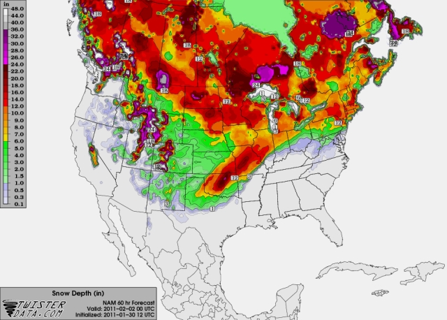
The 12z GFS, on the other hand, is much more conservative; showing just a few inches of snow mixed with some ice for most of the state..
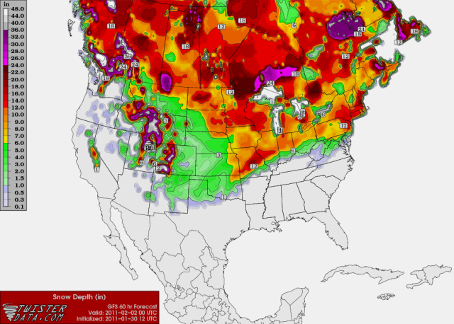
At the moment, I am inclined to believe that reality will wind up being somewhere in between the two model solutions.
It is showing a large corridor of a foot or more of snow, with a band of 18+ inches that includes most of the states largest population zones..
The 12z GFS, on the other hand, is much more conservative; showing just a few inches of snow mixed with some ice for most of the state..
At the moment, I am inclined to believe that reality will wind up being somewhere in between the two model solutions.
Last edited by Extremeweatherguy on Sun Jan 30, 2011 11:09 am, edited 2 times in total.
0 likes
-
Metalicwx220
Re: Winter 2010-11 for the Southern Plains
srainhoutx wrote:Metalicwx220 wrote:srainhoutx wrote:Don't forget about a late December Arctic Outbreak. Even La Nina years can throw a curveball or two.
Edit to add: We had a lot of great discussions in various threats last Winter. I look forward to the return of our Pro Mets and Winter Weather Watchers in a few month after the Tropical Season.
How did you know that? LOl that post was in july
Excuse me?
How did you know their was going to be a late december arctic outbreak?
0 likes
-
Portastorm

- Storm2k Moderator

- Posts: 9955
- Age: 63
- Joined: Fri Jul 11, 2003 9:16 am
- Location: Round Rock, TX
- Contact:
Re: Winter 2010-11 for the Southern Plains
Metalicwx220, for your edification, that kind of question is probably better served through a PM and not clogging up the bandwith with a huge quote and a brief question. We have a potentially serious weather event unfolding for much of the nation and folks are looking for forecast/weather information on the event in real time.
0 likes
-
Metalicwx220
Re: Winter 2010-11 for the Southern Plains
Portastorm wrote:Metalicwx220, for your edification, that kind of question is probably better served through a PM and not clogging up the bandwith with a huge quote and a brief question. We have a potentially serious weather event unfolding for much of the nation and folks are looking for forecast/weather information on the event in real time.
OK...
0 likes

Re: Winter 2010-11 for the Southern Plains
From your friendly neighbors higher up the hill to your west in Denver, consider yourselves lucky! We are only getting a few inches out of this one and then its going to be below zero for a high for the first time in like 14 years! -3 tuesday :-P
0 likes
-
TwisterFanatic
- Category 5
- Posts: 1041
- Joined: Mon Jun 28, 2010 12:43 pm
- Location: Sallisaw, Oklahoma
This could be a record setter. Pro-Mets around here using wording i have never seen them use. They're saying all of Oklahoma will see Major Winter Storm Impacts excluding far western Ok and The Panhandle.
0 likes
Personal Forecast Disclaimer:
The posts in this forum are NOT official forecast and should not be used as such. They are just the opinion of the poster and may or may not be backed by sound meteorological data. They are NOT endorsed by any professional institution or storm2k.org. For official information, please refer to the NHC and NWS products.
The posts in this forum are NOT official forecast and should not be used as such. They are just the opinion of the poster and may or may not be backed by sound meteorological data. They are NOT endorsed by any professional institution or storm2k.org. For official information, please refer to the NHC and NWS products.
-
Extremeweatherguy
- Category 5
- Posts: 11095
- Joined: Mon Oct 10, 2005 8:13 pm
- Location: Florida

Re:
Extremeweatherguy wrote:The 12z ECMWF is coming in closer to the NAM solution than the GFS solution. QPF values exceed an inch across OKC (1.20-1.40") in a sub-freezing airmass. With increasing snow ratios throughout the event, this would easily equate to 14-18+ inches. Amazing..
That would definitely break the 14 inch storm record from 09 or at least tie it! Pretty incredible.
0 likes
The above post and any post by Ntxw is NOT an official forecast and should not be used as such. It is just the opinion of the poster and may or may not be backed by sound meteorological data. It is NOT endorsed by any professional institution including Storm2k. For official information, please refer to NWS products.
Help support Storm2K!
-
TwisterFanatic
- Category 5
- Posts: 1041
- Joined: Mon Jun 28, 2010 12:43 pm
- Location: Sallisaw, Oklahoma
You guys might get lucky and get all snow, but as it looks right now i could get significant icing. 
0 likes
Personal Forecast Disclaimer:
The posts in this forum are NOT official forecast and should not be used as such. They are just the opinion of the poster and may or may not be backed by sound meteorological data. They are NOT endorsed by any professional institution or storm2k.org. For official information, please refer to the NHC and NWS products.
The posts in this forum are NOT official forecast and should not be used as such. They are just the opinion of the poster and may or may not be backed by sound meteorological data. They are NOT endorsed by any professional institution or storm2k.org. For official information, please refer to the NHC and NWS products.
-
BlueIce
- S2K Supporter
- Posts: 194
- Age: 37
- Joined: Mon Sep 01, 2008 10:05 pm
- Location: Oklahoma City, Oklahoma
Re: Winter 2010-11 for the Southern Plains
Extremeweatherguy wrote:The 12z ECMWF is coming in closer to the NAM solution than the GFS solution. QPF values exceed an inch across OKC (1.20-1.40") in a sub-freezing airmass. With increasing snow ratios throughout the event, this would easily equate to 14-18+ inches of snow accumulation. Amazing..
Ya looking at the text output from the ECMWF it looks like a whole day of freezing precip. With a total QPF of 1.4
And looking at some of the predicted wind gusts and sustained winds we might see a few blizzard warnings with this storm.

0 likes
Who is online
Users browsing this forum: No registered users and 130 guests