SPAC: YASI (14U /11P) - Severe Tropical Cyclone
Moderator: S2k Moderators
-
TheStormChaser
- Tropical Wave

- Posts: 3
- Joined: Tue Feb 01, 2011 8:11 am
-
HURAKAN

- Professional-Met

- Posts: 46084
- Age: 39
- Joined: Thu May 20, 2004 4:34 pm
- Location: Key West, FL
- Contact:
Re:
TheStormChaser wrote:I have heard word that the Bureau of Meteorology have been telling media outlets that the Willis Island obs station has been badly damaged or destroyed. No observations for the past 40mins they are reporting.
Almost an hour since the last obs and radar is also delayed. I won't be surprised if it's either destroyed or damaged.
0 likes

-
Rod Hagen
- Tropical Storm

- Posts: 237
- Joined: Fri Sep 23, 2005 6:22 am
- Location: Lives in Melbourne, works in N Queensland
Willis Island seems to be reporting obs again:
http://www.bom.gov.au/products/IDQ60801 ... 4299.shtml
02/09:00am 26.9 34.5 26.8 99 0.1 CALM 0 0 0 0 938.0 937.9 62.2
http://www.bom.gov.au/qld/observations/qldall.shtml has listings from all qld stations
Flinders Reef is the next place on the path for Obs - http://www.bom.gov.au/products/IDQ60801 ... 4290.shtml
No radar there , though.
0 likes


Re: SPAC: YASI (14U /11P) - Severe Tropical Cyclone
Yes Rod, it appears that the radar has been taken out at Willis Island. I suspect the instruments recording windspeed may have been "over maximum range" for about half an hour , but are now recording correctly again. I guess we will see in the next hour or so.
http://www.bom.gov.au/products/IDQ60801/IDQ60801.94299.shtml
http://www.bom.gov.au/products/IDQ60801/IDQ60801.94299.shtml
0 likes


Re: SPAC: YASI (14U /11P) - Severe Tropical Cyclone
the cyclone was likely to hit earlier than expected around 10pm (AEST)
http://www.news.com.au/breaking-news/ev ... 5998460940
QUEENSLAND Premier Anna Bligh says north Queenslanders at risk of tidal storm surges have very limited time to evacuate as Cyclone Yasi nears the coast as a category five.
The Bureau of Meteorology (BoM) in Brisbane said that at 4am AEST Yasi was about 650 kilometres east-northeast of Cairns and 650 kilometres northeast of Townsville moving west southwest at 30km/h.
"The cyclone has now reached category five and will continue to move in a west-southwesterly direction during today," the BoM said on its website this morning, as it upgraded its forecast from high category four.
Coastal residents, particularly between Port Douglas and Townsville, were being warned of an "extremely dangerous" storm tide as the cyclone approaches and crosses the coast. It is likely to cause flooding some way inland.
Winds with gusts to 90km/h were expected on coastal islands later on Wednesday morning, then extend on to the coast during the day.
Gusts over 125km/h were expected between Cooktown and Ingham in the afternoon, and gusts reaching above 280km/h between Port Douglas and Cardwell in the evening as the cyclone approached.
Ms Bligh told Sky News evacuations of low-lying areas were still taking place.
She said the cyclone was likely to hit earlier than expected around 10pm (AEST) at high tide.
"That means storm surges are an even greater problem today than we have contemplated yesterday.
"People still have a very small window of opportunity to move to a safer place."
She said they should relocate to homes of family and friends that are not at risk of the tidal surges.
http://www.news.com.au/breaking-news/ev ... 5998460940
Live coverage: Cyclone Yasi
http://www.news.com.au/breaking-news/fl ... 5997552623
Townsville Skycam Live
http://www.townsvillestorms.com/townsvilleskycam.html
http://www.news.com.au/breaking-news/ev ... 5998460940
QUEENSLAND Premier Anna Bligh says north Queenslanders at risk of tidal storm surges have very limited time to evacuate as Cyclone Yasi nears the coast as a category five.
The Bureau of Meteorology (BoM) in Brisbane said that at 4am AEST Yasi was about 650 kilometres east-northeast of Cairns and 650 kilometres northeast of Townsville moving west southwest at 30km/h.
"The cyclone has now reached category five and will continue to move in a west-southwesterly direction during today," the BoM said on its website this morning, as it upgraded its forecast from high category four.
Coastal residents, particularly between Port Douglas and Townsville, were being warned of an "extremely dangerous" storm tide as the cyclone approaches and crosses the coast. It is likely to cause flooding some way inland.
Winds with gusts to 90km/h were expected on coastal islands later on Wednesday morning, then extend on to the coast during the day.
Gusts over 125km/h were expected between Cooktown and Ingham in the afternoon, and gusts reaching above 280km/h between Port Douglas and Cardwell in the evening as the cyclone approached.
Ms Bligh told Sky News evacuations of low-lying areas were still taking place.
She said the cyclone was likely to hit earlier than expected around 10pm (AEST) at high tide.
"That means storm surges are an even greater problem today than we have contemplated yesterday.
"People still have a very small window of opportunity to move to a safer place."
She said they should relocate to homes of family and friends that are not at risk of the tidal surges.
http://www.news.com.au/breaking-news/ev ... 5998460940
Live coverage: Cyclone Yasi
http://www.news.com.au/breaking-news/fl ... 5997552623
Townsville Skycam Live
http://www.townsvillestorms.com/townsvilleskycam.html
0 likes


Re: SPAC: YASI (14U /11P) - Severe Tropical Cyclone
Obs at Wallis Island, eye is exiting now
http://www.weatherzone.com.au/station.jsp?lt=site&lc=200283&list=ob
http://www.weatherzone.com.au/station.jsp?lt=site&lc=200283&list=ob
0 likes
Re: SPAC: YASI (14U /11P) - Severe Tropical Cyclone
[youtube]http://www.youtube.com/watch?v=GuDyTfvjiX0[/youtube]
[youtube]http://www.youtube.com/watch?v=I0gPNVc70tk[/youtube]
http://www.goes.noaa.gov/sohemi/sohemil ... mscol.html
[youtube]http://www.youtube.com/watch?v=I0gPNVc70tk[/youtube]
http://www.goes.noaa.gov/sohemi/sohemil ... mscol.html
0 likes
Re: SPAC: YASI (14U /11P) - Severe Tropical Cyclone
JTE50 wrote:Obs at Wallis Island, eye is exiting now
http://www.weatherzone.com.au/station.jsp?lt=site&lc=200283&list=ob
pressure 938.6 hPa
http://www.weatherzone.com.au/radar.jsp ... arz&lc=041
http://www.theweatherchaser.com/radars/ ... -satellite
Last edited by Tom8 on Tue Feb 01, 2011 7:08 pm, edited 1 time in total.
0 likes
Re: SPAC: YASI (14U /11P) - Severe Tropical Cyclone
yeah and now back down to 937.6 so still in the eye for sure
0 likes


Re: SPAC: YASI (14U /11P) - Severe Tropical Cyclone
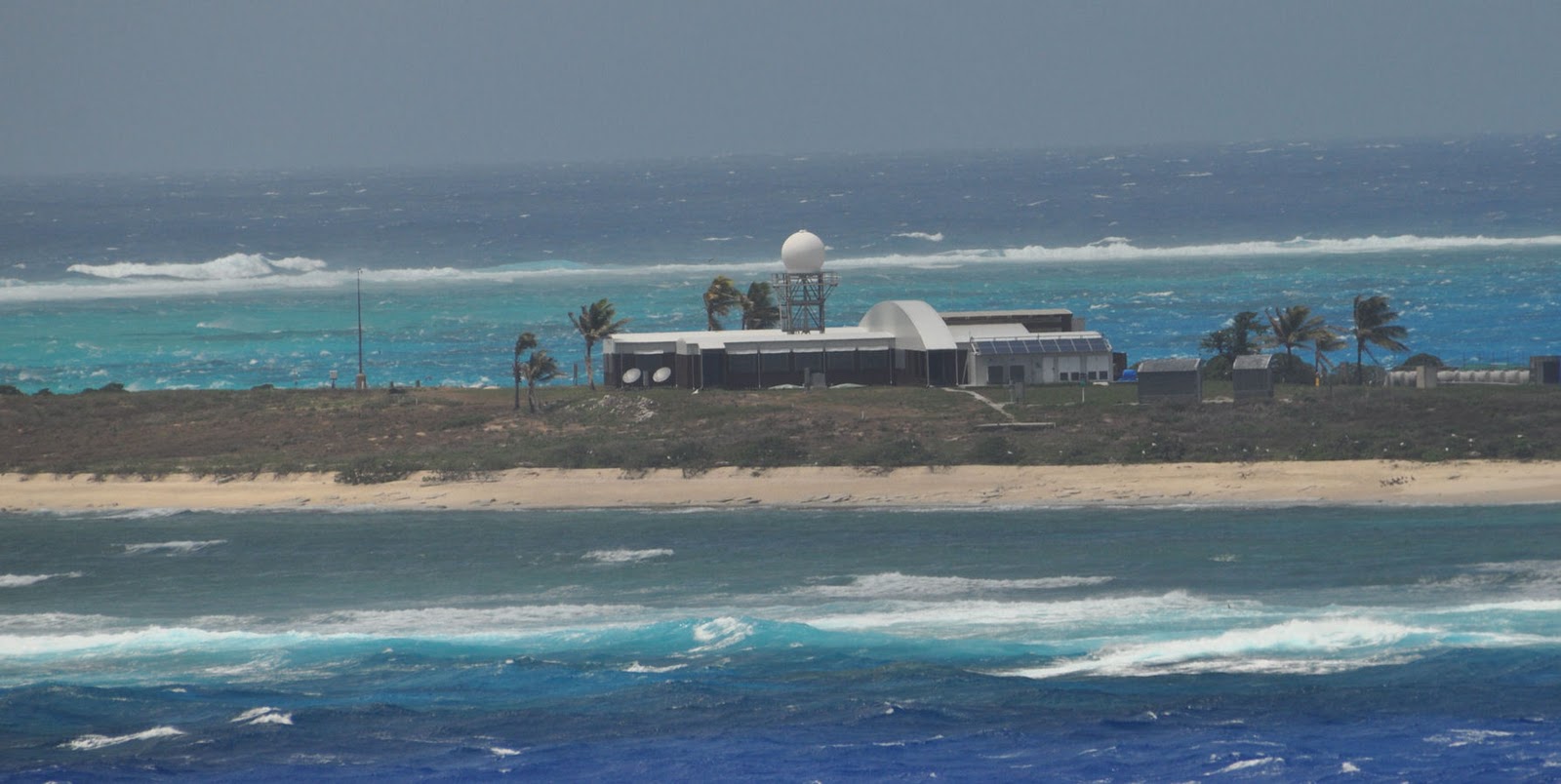
http://www.abc.net.au/news/stories/2011/02/02/3127757.htm?section=justin
Australian ABC news.
"Yasi knocks out weather radar
By Kim Lyell
The weather bureau's radar and wind speed measurements on the island failed just before 9am (AEST).
The bureau says the maximum wind speed recorded before the equipment went down was 185 kilometres an hour.
Three weather observers and a technician left the island yesterday."
0 likes
-
Crostorm

- Category 5

- Posts: 2060
- Age: 51
- Joined: Mon Dec 25, 2006 3:51 pm
- Location: Croatia-Europe
- Contact:
Re: SPAC: YASI (14U /11P) - Severe Tropical Cyclone
Wundermap Interactive Radar
http://www.wunderground.com/wundermap/? ... ib=0&tfk=0
http://www.wunderground.com/wundermap/? ... ib=0&tfk=0
0 likes
-
Dean4Storms
- S2K Supporter

- Posts: 6358
- Age: 63
- Joined: Sun Aug 31, 2003 1:01 pm
- Location: Miramar Bch. FL
Who is online
Users browsing this forum: No registered users and 19 guests