SE TX/SW LA Winter WX - 2011-2012

Winter Weather Discussion

Moderator: S2k Moderators

Forum rules

The posts in this forum are NOT official forecast and should not be used as such. They are just the opinion of the poster and may or may not be backed by sound meteorological data. They are NOT endorsed by any professional institution or STORM2K.

Help Support Storm2K
Message
Author
User avatar
srainhoutx
S2K Supporter
S2K Supporter
Posts: 6919
Age: 67
Joined: Sun Jan 14, 2007 11:34 am
Location: Haywood County, NC
Contact:

Re: SE TX/SW LA Winter Wx-VERY COLD! POSS WINTER STORM THUR/FRI

#1321 Postby srainhoutx » Thu Feb 03, 2011 8:19 am

This could be a very interesting 24 hours...

Image

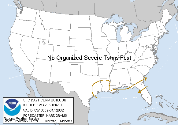
DAY 1 CONVECTIVE OUTLOOK
NWS STORM PREDICTION CENTER NORMAN OK
0614 AM CST THU FEB 03 2011

VALID 031300Z - 041200Z

...NO SVR TSTM AREAS FORECAST...

AN EXPANSIVE UPPER TROUGH IS IN PLACE THIS MORNING OVER THE
CONTIGUOUS UNITED STATES...WITH COLD AND RELATIVELY DRY CONDITIONS
EVERYWHERE BUT FL. A SURFACE COLD FRONT CONTINUES TO SAG SLOWLY
SOUTHWARD ACROSS THE NORTHERN FL PENINSULA...AND IS PROVIDING A
FOCUS FOR SCATTERED SHOWERS AND THUNDERSTORMS. MODELS SUGGEST THIS
THREAT WILL PERSIST THROUGH THE MORNING HOURS BEFORE SLOWLY
DIMINISHING THIS AFTERNOON.

FARTHER WEST...INCREASING LARGE SCALE FORCING AND LOW LEVEL WARM
ADVECTION WILL RESULT IN AN EXPANDING AREA OF PRECIPITATION THIS
AFTERNOON THROUGH TONIGHT OVER THE GULF COAST STATES. MODEL
GUIDANCE SUGGESTS VERY WEAK ELEVATED INSTABILITY /CENTERED AROUND
600MB/ WILL DEVELOP OVER SOUTHEAST TX/SOUTHWEST LA. THIS AREA MAY
SEE A FEW LIGHTNING STRIKES IN THE MOST ORGANIZED SHOWERS TONIGHT.


..HART/GRAMS.. 02/03/2011
0 likes   
Carla/Alicia/Jerry(In The Eye)/Michelle/Charley/Ivan/Dennis/Katrina/Rita/Wilma/Ike/Harvey

Member: National Weather Association
Wx Infinity Forums
http://wxinfinity.com/index.php

Facebook.com/WeatherInfinity
Twitter @WeatherInfinity

User avatar
southerngale
Retired Staff
Retired Staff
Posts: 27418
Joined: Thu Oct 10, 2002 1:27 am
Location: Southeast Texas (Beaumont area)

#1322 Postby southerngale » Thu Feb 03, 2011 9:03 am

hmmm, Steve. Would that suggest thundersnow is possible? They're saying showers. Whatever falls should be frozen in some shape or form. I don't know what to think.


Winter Storm Warning!


Winter Storm Warning

URGENT - WINTER WEATHER MESSAGE
NATIONAL WEATHER SERVICE LAKE CHARLES LA
454 AM CST THU FEB 3 2011

...SIGNIFICANT WINTER WEATHER EVENT EXPECTED LATE THURSDAY
AFTERNOON INTO FRIDAY MORNING...

.AS A STRONG UPPER LEVEL DISTURBANCE MOVES OUT OF THE SOUTHWEST
UNITED STATES AND TOWARD THE REGION...MOISTURE ABOVE THE SURFACE
WILL RAPIDLY INCREASE ON THURSDAY AFTERNOON. THIS WARM MOIST AIR
WILL OVER-RIDE A VERY COLD CONTINENTAL AIR MASS AT THE SURFACE.
THIS WILL HELP PRODUCE A WINTRY MIX OF FREEZING RAIN...SLEET AND
SNOW ACROSS THE REGION. DUE TO THE POSSIBLE DURATION AND INTENSITY
OF THE PRECIPITATION...SIGNIFICANT SLEET AND ICE ACCUMULATION WILL
BE POSSIBLE...ESPECIALLY NORTHWEST OF A BEAUMONT TO LAKE CHARLES
TO LAFAYETTE LINE.


LAZ027>033-041>045-TXZ180>182-201-215-216-032200-
/O.UPG.KLCH.WS.A.0001.110203T1800Z-110204T1500Z/
/O.NEW.KLCH.WS.W.0001.110203T1800Z-110204T1800Z/
VERNON-RAPIDES-AVOYELLES-BEAUREGARD-ALLEN-EVANGELINE-ST. LANDRY-
CALCASIEU-JEFFERSON DAVIS-ACADIA-LAFAYETTE-UPPER ST. MARTIN-TYLER-
JASPER-NEWTON-HARDIN-JEFFERSON-ORANGE-
INCLUDING THE CITIES OF...LEESVILLE...ALEXANDRIA...MARKSVILLE...
DERIDDER...OAKDALE...VILLE PLATTE...OPELOUSAS...LAKE CHARLES...
JENNINGS...CROWLEY...LAFAYETTE...ST. MARTINVILLE...WOODVILLE...
JASPER...NEWTON...LUMBERTON...BEAUMONT/PORT ARTHUR...ORANGE
454 AM CST THU FEB 3 2011

...WINTER STORM WARNING IN EFFECT FROM NOON TODAY TO NOON CST
FRIDAY...


THE NATIONAL WEATHER SERVICE IN LAKE CHARLES HAS ISSUED A WINTER
STORM WARNING FOR A MIX OF SNOW...SLEET...AND FREEZING RAIN...WHICH
IS IN EFFECT FROM NOON TODAY TO NOON CST FRIDAY.


A MIXTURE OF RAIN...SLEET...AND LIGHT FREEZING RAIN IS POSSIBLE
BY THURSDAY AFTERNOON. LITTLE ICE ACCUMULATION IS EXPECTED DURING
THE MORNING OR EARLY AFTERNOON AS THE PRECIPITATION WILL START
OUT VERY LIGHT WITH TEMPERATURES HOVERING JUST ABOVE FREEZING. THE
PRECIPITATION IS EXPECTED TO INCREASE IN INTENSITY LATE THURSDAY
AFTERNOON AND NIGHT WITH TEMPERATURES FALLING TO NEAR OR BELOW FREEZING.
THIS WILL ALLOW FOR ACCUMULATION OF ICE...SLEET AND SNOW...ESPECIALLY
ON ELEVATED SURFACES.

STORM TOTAL SNOW AND SLEET ACCUMULATIONS AROUND 2 INCHES...WITH
ISOLATED HIGHER AMOUNTS...WILL BE POSSIBLE NORTHWEST OF A LINE
FROM ALEXANDRIA TO SILSBEE.


STORM TOTAL ICE ACCUMULATIONS ALONG A LINE FROM ROUGHLY LAFAYETTE
TO LAKE CHARLES TO BEAUMONT...AND NORTHWEST TO ALEXANDRIA TO
SILSBEE...WILL AROUND 1/4 OF AN INCH...WITH ISOLATED HIGHER
AMOUNTS POSSIBLE.

THE PRECIPITATION IS EXPECTED TO DECREASE IN INTENSITY DURING
FRIDAY MORNING...THEN ENDING FROM WEST TO EAST FRIDAY AFTERNOON.

PRECAUTIONARY/PREPAREDNESS ACTIONS...

A WINTER STORM WARNING MEANS SIGNIFICANT AMOUNTS OF SNOW...
SLEET...AND ICE ARE EXPECTED. THIS WILL MAKE TRAVEL VERY
HAZARDOUS OR IMPOSSIBLE. ALSO...ACCUMULATION OF SLEET OR ICE ON
TREE LIMBS AND POWERLINES WILL BE POSSIBLE...CAUSING SOME POWER OUTAGES.


Falling to near or below freezing? It's already near or below freezing and not expected to climb much.
0 likes   
Please support Storm2k by making a donation today. It is greatly appreciated! Click here: Image

Image my Cowboys Image my RocketsImage my Astros

User avatar
southerngale
Retired Staff
Retired Staff
Posts: 27418
Joined: Thu Oct 10, 2002 1:27 am
Location: Southeast Texas (Beaumont area)

#1323 Postby southerngale » Thu Feb 03, 2011 9:06 am

Some FB posts by KFDM:

Greg Bostwick
Some sleet beginning to fall over sections of SE Texas with a mixture of freezing rain and sleet expected to increase later this afternoon into tonight. Could change to mainly sleet and snow Friday morning before ending around noon Friday. Highs today only around 34.
about an hour ago


KFDM News
Some sleet now beginning to fall over Hardin County southwest to Galveston. A mixture of freezing rain and sleet should increase this afternoon into tonight with the precip becoming more sleet and snow Friday morning before ending around noon Friday. Highs today only in the lower to middle 30's.
about an hour ago


KFDM News
Winter storm advisory: Sub-freezing temperatures and an upper level low pressure area will move across East and Southeast Texas beginning thid morning into Friday. Freezing rain, sleet or snow will cause roadways to ice over after dark on Thursday and a continuation of precipitation on Friday will keep the icing on the roads, bridges and overpasses for most of the day.
56 minutes ago


And my updated NWS forecast:

Winter Storm Warning
Hard Freeze Warning
Hazardous Weather Outlook

Today: Rain likely, possibly mixed with freezing rain and sleet after noon. Mostly cloudy, with a high near 34. North wind between 5 and 10 mph. Chance of precipitation is 60%. Little or no ice accumulation expected. Little or no snow accumulation expected.

Tonight: Freezing rain and sleet before midnight, then snow and sleet. Low around 28. North wind around 5 mph. Chance of precipitation is 80%. New ice accumulation of around a 0.1 of an inch possible. New snow and sleet accumulation of around an inch possible.

Friday: Snow and sleet likely before noon, then a chance of rain and sleet. Cloudy, with a high near 36. Northwest wind around 5 mph. Chance of precipitation is 60%. New snow and sleet accumulation of less than a half inch possible.


KFDM up to 60% today and 90% tomorrow (early in the day)
0 likes   
Please support Storm2k by making a donation today. It is greatly appreciated! Click here: Image

Image my Cowboys Image my RocketsImage my Astros

User avatar
srainhoutx
S2K Supporter
S2K Supporter
Posts: 6919
Age: 67
Joined: Sun Jan 14, 2007 11:34 am
Location: Haywood County, NC
Contact:

Re: SE TX/SW LA Winter Wx-VERY COLD! POSS WINTER STORM THUR/FRI

#1324 Postby srainhoutx » Thu Feb 03, 2011 9:08 am

Thunder snow/thunder sleet would be the main precip type in convective mesoscale banding, if it verifies, southerngale. Not something we normally would expect to see with a SE TX/SW LA Winter Weather Event... :cheesy:
0 likes   
Carla/Alicia/Jerry(In The Eye)/Michelle/Charley/Ivan/Dennis/Katrina/Rita/Wilma/Ike/Harvey

Member: National Weather Association
Wx Infinity Forums
http://wxinfinity.com/index.php

Facebook.com/WeatherInfinity
Twitter @WeatherInfinity

User avatar
southerngale
Retired Staff
Retired Staff
Posts: 27418
Joined: Thu Oct 10, 2002 1:27 am
Location: Southeast Texas (Beaumont area)

Re: SE TX/SW LA Winter Wx-VERY COLD! POSS WINTER STORM THUR/FRI

#1325 Postby southerngale » Thu Feb 03, 2011 9:12 am

srainhoutx wrote:Thunder snow/thunder sleet would be the main precip type in convective mesoscale banding, if it verifies, southerngale. Not something we normally would expect to see with a SE TX/SW LA Winter Weather Event... :cheesy:

No kidding! That would be amazing!

Meanwhile, many reports of light sleet and snow already coming in around here. Much earlier than expected. I haven't seen anything myself yet.
0 likes   
Please support Storm2k by making a donation today. It is greatly appreciated! Click here: Image

Image my Cowboys Image my RocketsImage my Astros

BigB0882
S2K Supporter
S2K Supporter
Posts: 2284
Joined: Thu Jul 03, 2003 12:08 am
Location: Baton Rouge, LA
Contact:

#1326 Postby BigB0882 » Thu Feb 03, 2011 9:12 am

I am wishing I had headed to Beaumont for a long weekend. Wouldn't be sitting in a cold rain all day, most likely. :(
0 likes   

User avatar
southerngale
Retired Staff
Retired Staff
Posts: 27418
Joined: Thu Oct 10, 2002 1:27 am
Location: Southeast Texas (Beaumont area)

#1327 Postby southerngale » Thu Feb 03, 2011 9:41 am

I hope you get some snow, BigB! Until I see it falling here, I'm still not confident that I will.


As locals mention road conditions becoming dangerous earlier than expected, school closings and early dismissals are coming in this morning.

KFDM has created a handy page for this.
0 likes   
Please support Storm2k by making a donation today. It is greatly appreciated! Click here: Image

Image my Cowboys Image my RocketsImage my Astros

User avatar
wxman57
Moderator-Pro Met
Moderator-Pro Met
Posts: 22978
Age: 67
Joined: Sat Jun 21, 2003 8:06 pm
Location: Houston, TX (southwest)

Re: SE TX/SW LA Winter Wx-VERY COLD! POSS WINTER STORM THUR/FRI

#1328 Postby wxman57 » Thu Feb 03, 2011 9:47 am

One of our employees in the Woodlands (north of Houston) is reporting off and on snow flurries as of 8:15am.
0 likes   

User avatar
srainhoutx
S2K Supporter
S2K Supporter
Posts: 6919
Age: 67
Joined: Sun Jan 14, 2007 11:34 am
Location: Haywood County, NC
Contact:

Re: SE TX/SW LA Winter Wx-VERY COLD! POSS WINTER STORM THUR/FRI

#1329 Postby srainhoutx » Thu Feb 03, 2011 9:54 am

AREA FORECAST DISCUSSION
NATIONAL WEATHER SERVICE HOUSTON/GALVESTON TX
846 AM CST THU FEB 3 2011

.UPDATE...
KHGX RADAR SHOWS A BAND OF LIGHT RETURNS ALONG THE US 59 CORRIDOR
INCLUDING OVER HARRIS COUNTY. IN ADDITION...WE RECEIVED A REPORT
OF SLEET IN POLK COUNTY. WOULD NOT BE SURPRISED TO SEE SOME
REPORTS OF LIGHT SLEET AND SNOW IN THE HOUSTON AREA IN THE NEXT
COUPLE OF HOURS. AS A RESULT HAVE MADE SOME CHANGES TO UP POPS FOR
THE FIRST PERIOD OF THE FORECAST. IN ADDITION...ADJUSTED TEMPS
BASED ON CURRENT TRENDS. MODEL FORECAST SOUNDINGS INDICATE THAT
THE ATMOSPHERE WILL TAKE QUITE A WHILE TO SATURATE...WITH THE
PRECIP REMAINING VERY LIGHT THROUGH THE EARLY EVENING HOURS. THE
MAIN EVENT IS EXPECTED IN THE 06-12Z TIME FRAME TONIGHT.
NO
CHANGES TO THE WARNING OR TO FORECAST AMOUNTS AT THIS TIME.

0 likes   
Carla/Alicia/Jerry(In The Eye)/Michelle/Charley/Ivan/Dennis/Katrina/Rita/Wilma/Ike/Harvey

Member: National Weather Association
Wx Infinity Forums
http://wxinfinity.com/index.php

Facebook.com/WeatherInfinity
Twitter @WeatherInfinity

setxwxgurl
Tropical Low
Tropical Low
Posts: 15
Joined: Tue Jan 04, 2011 11:32 am

Re: SE TX/SW LA Winter Wx-VERY COLD! POSS WINTER STORM THUR/FRI

#1330 Postby setxwxgurl » Thu Feb 03, 2011 10:09 am

Light sleet in Orange
0 likes   

CYCLONE MIKE
Category 5
Category 5
Posts: 2183
Joined: Tue Aug 31, 2004 6:04 pm
Location: Gonzales, LA

Re:

#1331 Postby CYCLONE MIKE » Thu Feb 03, 2011 10:19 am

southerngale wrote:I hope you get some snow, BigB! Until I see it falling here, I'm still not confident that I will.


As locals mention road conditions becoming dangerous earlier than expected, school closings and early dismissals are coming in this morning.

KFDM has created a handy page for this.


No snow for Baton Rouge this time around southerngale. A little freezing rain this morning then nothing but a very cold rain through friday. Oh well. Didn't expect much some I'm not disappointed. Ya'll enjoy what you get over there and make sure to post some nice pics as well. :wink:
0 likes   

User avatar
Dave
Retired Staff
Retired Staff
Posts: 13442
Age: 74
Joined: Tue Aug 01, 2006 3:57 pm
Location: Milan Indiana
Contact:

Re: SE TX/SW LA Winter Wx-VERY COLD! POSS WINTER STORM THUR/FRI

#1332 Postby Dave » Thu Feb 03, 2011 10:28 am

srainhoutx & southerngale we'd best see some pictures from you of this event! I am soooooooooo happy to hear about you'all getting snow/sleet/freezing rain cause now maybe I won't get this round. :lol: ENJOY!!! You deserve it!
0 likes   

User avatar
srainhoutx
S2K Supporter
S2K Supporter
Posts: 6919
Age: 67
Joined: Sun Jan 14, 2007 11:34 am
Location: Haywood County, NC
Contact:

Re: SE TX/SW LA Winter Wx-VERY COLD! POSS WINTER STORM THUR/FRI

#1333 Postby srainhoutx » Thu Feb 03, 2011 10:30 am

Dave wrote:srainhoutx & southerngale we'd best see some pictures from you of this event! I am soooooooooo happy to hear about you'all getting snow/sleet/freezing rain cause now maybe I won't get this round. :lol: ENJOY!!! You deserve it!


Thanks Dave. Hopefully we'll have some pics to post tomorrow morning. Stay warm up there. It's :cold: down here. Brrr...
0 likes   
Carla/Alicia/Jerry(In The Eye)/Michelle/Charley/Ivan/Dennis/Katrina/Rita/Wilma/Ike/Harvey

Member: National Weather Association
Wx Infinity Forums
http://wxinfinity.com/index.php

Facebook.com/WeatherInfinity
Twitter @WeatherInfinity

User avatar
Dave
Retired Staff
Retired Staff
Posts: 13442
Age: 74
Joined: Tue Aug 01, 2006 3:57 pm
Location: Milan Indiana
Contact:

Re: SE TX/SW LA Winter Wx-VERY COLD! POSS WINTER STORM THUR/FRI

#1334 Postby Dave » Thu Feb 03, 2011 10:32 am

You want cold? It's 17 degrees up here with pure blue skies & snow cover. :cold:
0 likes   

Nederlander
S2K Supporter
S2K Supporter
Posts: 1250
Joined: Sat Jul 19, 2008 4:28 pm
Location: Conroe, TX

Re: SE TX/SW LA Winter Wx-VERY COLD! POSS WINTER STORM THUR/FRI

#1335 Postby Nederlander » Thu Feb 03, 2011 10:33 am

I have the window shades in my office open and I am keeping a lookout. Not far from you southerngale. I work over here close to 105.
0 likes   

User avatar
srainhoutx
S2K Supporter
S2K Supporter
Posts: 6919
Age: 67
Joined: Sun Jan 14, 2007 11:34 am
Location: Haywood County, NC
Contact:

Re: SE TX/SW LA Winter Wx-VERY COLD! POSS WINTER STORM THUR/FRI

#1336 Postby srainhoutx » Thu Feb 03, 2011 10:35 am

Dave wrote:You want cold? It's 17 degrees up here with pure blue skies & snow cover. :cold:


18.2F here yesterday morning and a balmy 25F now. :lol:
0 likes   
Carla/Alicia/Jerry(In The Eye)/Michelle/Charley/Ivan/Dennis/Katrina/Rita/Wilma/Ike/Harvey

Member: National Weather Association
Wx Infinity Forums
http://wxinfinity.com/index.php

Facebook.com/WeatherInfinity
Twitter @WeatherInfinity

User avatar
Dave
Retired Staff
Retired Staff
Posts: 13442
Age: 74
Joined: Tue Aug 01, 2006 3:57 pm
Location: Milan Indiana
Contact:

Re: SE TX/SW LA Winter Wx-VERY COLD! POSS WINTER STORM THUR/FRI

#1337 Postby Dave » Thu Feb 03, 2011 10:37 am

srainhoutx wrote:
Dave wrote:You want cold? It's 17 degrees up here with pure blue skies & snow cover. :cold:


18.2F here yesterday morning and a balmy 25F now. :lol:


LOL I'll send our next major down to you too! Enjoy it all...snow can be fun at times....but after the 12th time it can get old. LOL
0 likes   

User avatar
PTrackerLA
Category 5
Category 5
Posts: 5277
Age: 41
Joined: Thu Oct 10, 2002 8:40 pm
Location: Lafayette, LA

Re: SE TX/SW LA Winter Wx-VERY COLD! POSS WINTER STORM THUR/FRI

#1338 Postby PTrackerLA » Thu Feb 03, 2011 10:40 am

Just had some light freezing rain in Lafayette, just checked a metal sign outside and ice is forming on it. Looks like a break for a while but more is coming in from the gulf. Wonder if we will stay all freezing today? Car said 30 just a little while ago so we'll see.
0 likes   

User avatar
Dave
Retired Staff
Retired Staff
Posts: 13442
Age: 74
Joined: Tue Aug 01, 2006 3:57 pm
Location: Milan Indiana
Contact:

#1339 Postby Dave » Thu Feb 03, 2011 10:44 am

There are some snow/sleet/freezing rain graphics on the Lake Charles nws site here...

http://www.srh.noaa.gov/graphicast.php?site=lch&gc=1


but you'all probably already hit them a million times already this morning haven't ya? j/k Here's wishing all of you the best snow storm possible! Just be safe when driving in it...we're pro's up here, you guys/gals are amateurs and would like to have you check in here during the event and not the ER. :lol:

*Edit: been awhile since hurricane season..I cant' even get a link to work right on here! LOL
0 likes   

CajunMama
Retired Staff
Retired Staff
Posts: 10791
Joined: Thu Feb 06, 2003 9:57 pm
Location: 30.22N, 92.05W Lafayette, LA

Re: SE TX/SW LA Winter Wx-VERY COLD! POSS WINTER STORM THUR/FRI

#1340 Postby CajunMama » Thu Feb 03, 2011 11:30 am

Temps hovering around freezing. I am at my sons house where I am waiting for the heater guy. Temp in the house is 53. On the way over here it was raining and did freeze on the car.
0 likes   


Return to “Winter Weather”

Who is online

Users browsing this forum: No registered users and 2 guests