Texas Winter 2010-2011
Moderator: S2k Moderators
Forum rules
 The posts in this forum are NOT official forecast and should not be used as such. They are just the opinion of the poster and may or may not be backed by sound meteorological data. They are NOT endorsed by any professional institution or STORM2K.

The posts in this forum are NOT official forecast and should not be used as such. They are just the opinion of the poster and may or may not be backed by sound meteorological data. They are NOT endorsed by any professional institution or STORM2K.
-
srainhoutx

- S2K Supporter

- Posts: 6919
- Age: 68
- Joined: Sun Jan 14, 2007 11:34 am
- Location: Haywood County, NC
- Contact:
Re: Texas Winter 2010-2011
The 12Z Canadian (GEM) may raise some eyebrows...
0 likes
Carla/Alicia/Jerry(In The Eye)/Michelle/Charley/Ivan/Dennis/Katrina/Rita/Wilma/Ike/Harvey
Member: National Weather Association
Wx Infinity Forums
http://wxinfinity.com/index.php
Facebook.com/WeatherInfinity
Twitter @WeatherInfinity
Member: National Weather Association
Wx Infinity Forums
http://wxinfinity.com/index.php
Facebook.com/WeatherInfinity
Twitter @WeatherInfinity


GFS did horrible on the timing of the front last week...
The 24 hour forecast from the 12z from the GFS run on the 31st had the front through my house by noon and it was supposed to be 38F at that time.
The front hit my house at 6:16AM and it was 39F by 6:30AM on Feb 1st.
The 24 hour forecast from the 12z from the GFS run on the 31st had the front through my house by noon and it was supposed to be 38F at that time.
The front hit my house at 6:16AM and it was 39F by 6:30AM on Feb 1st.
0 likes
“If you thought that science was certain - well, that is just an error on your part.”
-
Portastorm

- Storm2k Moderator

- Posts: 9955
- Age: 63
- Joined: Fri Jul 11, 2003 9:16 am
- Location: Round Rock, TX
- Contact:
Re: Texas Winter 2010-2011
I'm in no position to debate/contest your statement about the GFS doing "quite well" with last week's event, wxman57. But my recollection from looking at just about every GFS model run prior to the winter weather last week was that it did not do well at all until maybe 24 hours before the event. Even then it showed 1-2 inches of snow for AUS and we didn't even technically get an inch. Also, did the GFS show the warm air at 850mb which created our freezing drizzle Thursday night? If it did, then the NWS ignored it because that was never in our forecast.
Also, the GFS did not capture the cold air temps right after the front passed earlier last week. It was about six hours too slow.
Also, the GFS did not capture the cold air temps right after the front passed earlier last week. It was about six hours too slow.
0 likes
-
wxman57

- Moderator-Pro Met

- Posts: 23175
- Age: 68
- Joined: Sat Jun 21, 2003 8:06 pm
- Location: Houston, TX (southwest)
Re:
txagwxman wrote:GFS did horrible on the timing of the front last week...
The 24 hour forecast from the 12z from the GFS run on the 31st had the front through my house by noon and it was supposed to be 38F at that time.
The front hit my house at 6:16AM and it was 39F by 6:30AM on Feb 1st.
Right, the models may have a hard time with the arrival time of the front. But it's quite difficult to get more than a few sleet pellets immediately post-frontal this far south because the airmass in place ahead of the front will not be very cold. Certainly, I wouldn't expect an ice storm across central to SE TX from this front. A few sleet pellets that melt as they reach the ground, maybe.
0 likes
-
CaptinCrunch

- S2K Supporter
- Posts: 8780
- Age: 58
- Joined: Mon Nov 03, 2003 4:33 pm
- Location: Kennedale, TX (Tarrant Co.)
Do not be surprised to another 6"+ snowfall across DFW Tuesday night into Wednesday. 
Enjoy it now, because this may be the last winter weather event we see this season across DFW, as 70's and even the 80's return by next weekend.
Enjoy it now, because this may be the last winter weather event we see this season across DFW, as 70's and even the 80's return by next weekend.
Last edited by CaptinCrunch on Mon Feb 07, 2011 12:00 pm, edited 1 time in total.
0 likes
-
wxman57
- Moderator-Pro Met
- Posts: 23175
- Age: 68
- Joined: Sat Jun 21, 2003 8:06 pm
- Location: Houston, TX (southwest)
Re: Texas Winter 2010-2011
Portastorm wrote:I'm in no position to debate/contest your statement about the GFS doing "quite well" with last week's event, wxman57. But my recollection from looking at just about every GFS model run prior to the winter weather last week was that it did not do well at all until maybe 24 hours before the event. Even then it showed 1-2 inches of snow for AUS and we didn't even technically get an inch. Also, did the GFS show the warm air at 850mb which created our freezing drizzle Thursday night? If it did, then the NWS ignored it because that was never in our forecast.
Also, the GFS did not capture the cold air temps right after the front passed earlier last week. It was about six hours too slow.
You're right about the GFS missing the warm layer aloft, Portastorm. But it did very well with the precip amounts and timing across the Houston area. Remember that the Euro and particularly the Canadian were forecasting up to 1/2" of precip or more here, but we ended up with around 0.1", very close to the GFS forecast. Unfortunately, that came as freezing rain. I didn't even attempt to get to work Friday.
But all we are talking about with this week's front is the possibility that some sleet may mix in with the rain as the precip ends from Austin to College Station to Lufkin. Surface temps would need to be colder for it to stick. And the logical question to follow would be as to whether the current model runs are cold enough immediately post-frontal?
Personally, I'm ready for the big thaw next week and beyond. Soon it'll be time to start talking severe weather and then tropical!
0 likes
-
Portastorm
- Storm2k Moderator
- Posts: 9955
- Age: 63
- Joined: Fri Jul 11, 2003 9:16 am
- Location: Round Rock, TX
- Contact:
Re: Texas Winter 2010-2011
Yes, on this we can definitely agree ... bring on severe weather season and the tropics! 
0 likes
-
wxman22

- Category 5

- Posts: 1953
- Joined: Mon Jan 30, 2006 12:39 am
- Location: Wichita Falls, TX
- Contact:
Re: Texas Winter 2010-2011
Just curious, what are you looking at to make that determination? I'm looking at the 6hr precip forecasts from the 00Z Euro and see the precip ending in Austin by early afternoon Wednesday and in College Station by 6pm Wednesday. It appears to have Austin above freezing when the precip ends and College Station in the 32-34 deg range when precip ends. Could be some sleet potential, but not much.
I was looking at the Euro text output
CLL: Shows .24 of precip during the transition to freezing and then .02 qpfs with temperatures below freezing. So therefore at least a little frozen precipitation would fall in College Station.
0 likes
-
Ivanhater

- Storm2k Moderator
- Posts: 11221
- Age: 39
- Joined: Fri Jul 01, 2005 8:25 am
- Location: Pensacola
Re: Texas Winter 2010-2011
wxman57 wrote:Personally, I'm ready for the big thaw next week and beyond. Soon it'll be time to start talking severe weather and then tropical!
Post of the month! Bring on the warmth! This winter has been very cold and I have had enough. I'm screaming Uncle!
0 likes
Michael
-
Texas2Florida

- Tropical Depression

- Posts: 71
- Joined: Thu Dec 03, 2009 12:17 am
- Location: NE Pennsylvania backwoods
Re: Texas Winter 2010-2011
Ivanhater wrote:wxman57 wrote:Personally, I'm ready for the big thaw next week and beyond. Soon it'll be time to start talking severe weather and then tropical!
Post of the month! Bring on the warmth! This winter has been very cold and I have had enough. I'm screaming Uncle!
Wondering what this whole weather pattern means for the tropical season....La Nina into neutral by the height of it..should be moderately active..
0 likes
Real women wear firesuits! --self proclaimed NASCAR princess.
-
srainhoutx
- S2K Supporter
- Posts: 6919
- Age: 68
- Joined: Sun Jan 14, 2007 11:34 am
- Location: Haywood County, NC
- Contact:
Re: Texas Winter 2010-2011
HPC:
...WAVE CROSSING THE GULF STATES DAY 3...
PRELIMINARY PREFERENCE: PENDING 12Z/07 ECMWF
THE NAM IS LESS SUPPRESSED WITH THE TRACK OF THIS SYSTEM THAN THE
00Z/07 ECMWF...WITH THE GFS SLIGHTLY MORE SUPPRESSED. THE GEM
GLOBAL IS CLOSEST TO THE ECMWF...WITH THE UKMET CLOSEST TO THE
NAM. CONSIDERING THE TRENDING OF THE GUIDANCE WITH THIS ENERGETIC
FEATURE...WILL WAIT FOR THE 12Z/07 TO MAKE A CALL HERE.
0 likes
Carla/Alicia/Jerry(In The Eye)/Michelle/Charley/Ivan/Dennis/Katrina/Rita/Wilma/Ike/Harvey
Member: National Weather Association
Wx Infinity Forums
http://wxinfinity.com/index.php
Facebook.com/WeatherInfinity
Twitter @WeatherInfinity
Member: National Weather Association
Wx Infinity Forums
http://wxinfinity.com/index.php
Facebook.com/WeatherInfinity
Twitter @WeatherInfinity
-
cycloneye

- Admin

- Posts: 149505
- Age: 69
- Joined: Thu Oct 10, 2002 10:54 am
- Location: San Juan, Puerto Rico
Re: Texas Winter 2010-2011
Texas2Florida wrote:Ivanhater wrote:wxman57 wrote:Personally, I'm ready for the big thaw next week and beyond. Soon it'll be time to start talking severe weather and then tropical!
Post of the month! Bring on the warmth! This winter has been very cold and I have had enough. I'm screaming Uncle!
Wondering what this whole weather pattern means for the tropical season....La Nina into neutral by the height of it..should be moderately active..
What about starting to think about this?
0 likes
Visit the Caribbean-Central America Weather Thread where you can find at first post web cams,radars
and observations from Caribbean basin members Click Here
and observations from Caribbean basin members Click Here
-
srainhoutx
- S2K Supporter
- Posts: 6919
- Age: 68
- Joined: Sun Jan 14, 2007 11:34 am
- Location: Haywood County, NC
- Contact:
Re: Texas Winter 2010-2011
Hmmm...still looking like a close call, but what do I know... 
0 likes
Carla/Alicia/Jerry(In The Eye)/Michelle/Charley/Ivan/Dennis/Katrina/Rita/Wilma/Ike/Harvey
Member: National Weather Association
Wx Infinity Forums
http://wxinfinity.com/index.php
Facebook.com/WeatherInfinity
Twitter @WeatherInfinity
Member: National Weather Association
Wx Infinity Forums
http://wxinfinity.com/index.php
Facebook.com/WeatherInfinity
Twitter @WeatherInfinity
-
orangeblood
- S2K Supporter
- Posts: 3895
- Joined: Tue Dec 15, 2009 6:14 pm
- Location: Fort Worth, TX
Re: Texas Winter 2010-2011
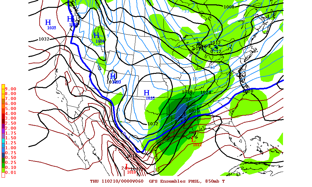
srainhoutx wrote:Hmmm...still looking like a close call, but what do I know...
http://i228.photobucket.com/albums/ee29 ... p12060.gif
The 12Z GFS ensembles are much quicker with this system than past runs... with most of the heavy precip over by 12Z Wednesday morning across North Texas. Very similar to last Tuesday's winter storm but with less precip.
0 likes
-
orangeblood
- S2K Supporter
- Posts: 3895
- Joined: Tue Dec 15, 2009 6:14 pm
- Location: Fort Worth, TX
Re: Texas Winter 2010-2011
Hmm....12Z Euro and Ukmet slower with the front and a little less precip for DFW. These models are all over the place. Very tough forecast once again for the Fort Worth office!!!!! The Norman office actually has an easier forecast this time around with precip falling mostly as snow.
0 likes

Re: Texas Winter 2010-2011
FW office was quick to put up the WSW and I bet they'll be slow to take it down after last week. At this point, a lot of metroplexers won't hold it against them if this is a bust anyway. Bring on spring..
0 likes

Re: Texas Winter 2010-2011
The OKC weatherman are calling for 6-10 for southwest Ok. Is that the way you see it?
0 likes
Who is online
Users browsing this forum: No registered users and 234 guests