Historic Multi Day Tornado/Flooding Event 4/23-28/2011

U.S. & Caribbean Weather Discussions and Severe Weather Events

Moderator: S2k Moderators

Forum rules

The posts in this forum are NOT official forecast and should not be used as such. They are just the opinion of the poster and may or may not be backed by sound meteorological data. They are NOT endorsed by any professional institution or STORM2K.

Help Support Storm2K
Message
Author
User avatar
srainhoutx
S2K Supporter
S2K Supporter
Posts: 6919
Age: 67
Joined: Sun Jan 14, 2007 11:34 am
Location: Haywood County, NC
Contact:

Historic Multi Day Tornado/Flooding Event 4/23-28/2011

#1 Postby srainhoutx » Wed Apr 20, 2011 9:01 am

Models are advertising a very deep and vigorous long wave trough across the Central US early next week. A very robust series of low pressure systems look to be envolved providing for a large and widespread severe weather event from the Southern Plains and points ENE...

SPC:

WITH LIKELY AMPLIFICATION OF THE LARGE SCALE PATTERN VIA THE
EVOLUTION OF A PROMINENT WESTERN/CENTRAL CONUS UPPER TROUGH BY DAYS
5-6 SUNDAY/MONDAY...PRELIMINARY THINKING IS THAT A MORE
WIDESPREAD/MULTI-ROUND SEVERE THREAT MAY EVOLVE THROUGH DAYS 6-8
MONDAY/TUESDAY/WEDNESDAY FROM THE SOUTHERN PLAINS EAST-NORTHEASTWARD
INTO THE MIDWEST/MS RIVER VALLEY. BUT...SPECIFIC PREDICTABILITY IS
STILL QUITE LIMITED IN THIS TIME FRAME.


Image
0 likes   
Carla/Alicia/Jerry(In The Eye)/Michelle/Charley/Ivan/Dennis/Katrina/Rita/Wilma/Ike/Harvey

Member: National Weather Association
Wx Infinity Forums
http://wxinfinity.com/index.php

Facebook.com/WeatherInfinity
Twitter @WeatherInfinity

User avatar
GCANE
S2K Supporter
S2K Supporter
Posts: 11453
Joined: Mon Oct 22, 2007 8:03 am

Re: Potential Widespread Severe Weather Event 4/25-27/2011

#2 Postby GCANE » Wed Apr 20, 2011 11:23 am

500mb GFS looks potent.

Image

Image

Image
0 likes   

User avatar
GCANE
S2K Supporter
S2K Supporter
Posts: 11453
Joined: Mon Oct 22, 2007 8:03 am

Re: Potential Widespread Severe Weather Event 4/25-27/2011

#3 Postby GCANE » Wed Apr 20, 2011 11:27 am

Image
0 likes   

User avatar
GCANE
S2K Supporter
S2K Supporter
Posts: 11453
Joined: Mon Oct 22, 2007 8:03 am

Re: Potential Widespread Severe Weather Event 4/25-27/2011

#4 Postby GCANE » Wed Apr 20, 2011 11:41 am

Image
0 likes   

User avatar
cheezyWXguy
Category 5
Category 5
Posts: 6091
Joined: Mon Feb 13, 2006 12:29 am
Location: Dallas, TX

#5 Postby cheezyWXguy » Wed Apr 20, 2011 5:42 pm

How far south are we talking here? I know its pretty far out, but is this looking like a potential threat to the OK/NTX area? If so it could have some effect on my family's travel plans.
0 likes   

User avatar
GCANE
S2K Supporter
S2K Supporter
Posts: 11453
Joined: Mon Oct 22, 2007 8:03 am

Re:

#6 Postby GCANE » Wed Apr 20, 2011 7:43 pm

cheezyWXguy wrote:How far south are we talking here? I know its pretty far out, but is this looking like a potential threat to the OK/NTX area? If so it could have some effect on my family's travel plans.


To me at this point, looks like a classic dryline / triple-point firing mid TX and OK Monday afternoon.

Then Tuesday, could be upper MS Valley.

Keep an eye on the model runs to see if this changes.
0 likes   

User avatar
srainhoutx
S2K Supporter
S2K Supporter
Posts: 6919
Age: 67
Joined: Sun Jan 14, 2007 11:34 am
Location: Haywood County, NC
Contact:

Re: Potential Widespread Severe Weather Event 4/25-27/2011

#7 Postby srainhoutx » Thu Apr 21, 2011 7:46 am

Image

DAY 4-8 CONVECTIVE OUTLOOK
NWS STORM PREDICTION CENTER NORMAN OK
0359 AM CDT THU APR 21 2011

VALID 241200Z - 291200Z

...DISCUSSION...
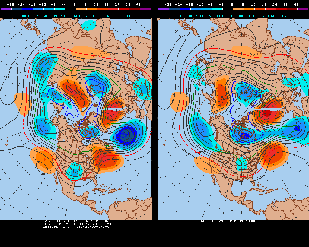
WHILE SOME DETAILS VARY...THE 00Z ECMWF/GEFS/UKMET ARE IN AMPLE
GENERAL AGREEMENT WITH THE EXPECTED AMPLIFICATION OF THE LARGE SCALE
PATTERN LATE THIS WEEKEND/EARLY NEXT WEEK...HIGHLIGHTED BY A
PROMINENT WESTERN/CENTRAL CONUS UPPER TROUGH.

ON DAY 4/SUNDAY...THE SOUTHERN HIGH PLAINS WILL LIKELY BE A FOCUS
FOR AT LEAST SOME SURFACE BASED SEVERE THREAT NEAR/EAST OF A DRYLINE
ACROSS WEST TX AND PERHAPS INTO OK. OTHER ELEVATED STORMS CAPABLE OF
SEVERE HAIL ARE PROBABLE SUNDAY NIGHT FROM OK INTO THE OZARKS/LOWER
MO VALLEY. BUT GIVEN LINGERING UNCERTAINTY REGARDING THE EXTENT OF
PRE-DARK SURFACE BASED DEEP CONVECTION...LARGELY OWING TO
ANTICIPATED MODEST LARGE SCALE FORCING FOR ASCENT/ONLY WEAK HEIGHT
FALLS...TOO MUCH UNCERTAINTY CURRENTLY EXISTS TO DELINEATE A 30
PERCENT EQUIVALENT SEVERE RISK AREA.

FOR DAY 5/MONDAY...HAVE INTRODUCED A SEVERE RISK AREA FOR PORTIONS
OF THE SOUTHERN PLAINS TO THE ARKLATEX/OZARKS. WHILE TIMING/SPATIAL
DETAILS VARY TO A DEGREE...REASONABLE CONFIDENCE EXISTS THAT A
SOUTHERN STREAM SHORTWAVE TROUGH WILL OVERSPREAD A MOIST AIRMASS TO
THE EAST OF THE DRYLINE/COLD FRONT. AS SUCH...SEVERE STORMS SEEM
LIKELY MONDAY/MONDAY NIGHT ACROSS THIS REGION.

INTO DAYS 6/7 TUESDAY/WEDNESDAY...AS THE NEXT PORTION OF THE CENTRAL
CONUS UPPER TROUGH PIVOTS EASTWARD...A RELATIVELY
WIDESPREAD/MULTI-ROUND SEVERE THREAT IS EXPECTED FROM THE SOUTHERN
PLAINS EAST-NORTHEASTWARD INTO THE MIDWEST AND LOWER/MIDDLE MS RIVER
VALLEY. WHILE SEVERE STORMS SEEM LIKELY EACH OF THESE
DAYS...SPECIFIC PREDICTABILITY IS STILL QUITE LIMITED IN THIS TIME
FRAME.

..GUYER.. 04/21/2011
0 likes   
Carla/Alicia/Jerry(In The Eye)/Michelle/Charley/Ivan/Dennis/Katrina/Rita/Wilma/Ike/Harvey

Member: National Weather Association
Wx Infinity Forums
http://wxinfinity.com/index.php

Facebook.com/WeatherInfinity
Twitter @WeatherInfinity

User avatar
srainhoutx
S2K Supporter
S2K Supporter
Posts: 6919
Age: 67
Joined: Sun Jan 14, 2007 11:34 am
Location: Haywood County, NC
Contact:

Re: Potential Widespread Severe Weather Event 4/25-27/2011

#8 Postby srainhoutx » Thu Apr 21, 2011 9:29 am

Yikes! Look at the flood potential for this multi day event...

Image
0 likes   
Carla/Alicia/Jerry(In The Eye)/Michelle/Charley/Ivan/Dennis/Katrina/Rita/Wilma/Ike/Harvey

Member: National Weather Association
Wx Infinity Forums
http://wxinfinity.com/index.php

Facebook.com/WeatherInfinity
Twitter @WeatherInfinity

User avatar
somethingfunny
ChatStaff
ChatStaff
Posts: 3926
Age: 36
Joined: Thu May 31, 2007 10:30 pm
Location: McKinney, Texas

Re: Potential Widespread Severe Weather Event 4/25-27/2011

#9 Postby somethingfunny » Thu Apr 21, 2011 1:12 pm

That's awful for NW Arkansas, but I'm heartened to see 2"+ QPF for the wildfire areas around and south of Wichita Falls.
0 likes   
I am not a meteorologist, and any posts made by me are not official forecasts or to be interpreted as being intelligent. These posts are just my opinions and are probably silly opinions.

User avatar
vbhoutex
Storm2k Executive
Storm2k Executive
Posts: 29096
Age: 73
Joined: Wed Oct 09, 2002 11:31 pm
Location: Cypress, TX
Contact:

Re: Potential Widespread Severe Weather Event 4/25-27/2011

#10 Postby vbhoutex » Thu Apr 21, 2011 5:32 pm

somethingfunny wrote:That's awful for NW Arkansas, but I'm heartened to see 2"+ QPF for the wildfire areas around and south of Wichita Falls.

That's awful for the Ohio Valley and Mid Mississippi Valley and the states in that area. That kind of rainfall is the last thing they need this time of year.
0 likes   
Skywarn, C.E.R.T.
Please click below to donate to STORM2K to help with the expenses of keeping the site going:
Image

User avatar
srainhoutx
S2K Supporter
S2K Supporter
Posts: 6919
Age: 67
Joined: Sun Jan 14, 2007 11:34 am
Location: Haywood County, NC
Contact:

Re: Potential Widespread Severe Weather Event 4/25-27/2011

#11 Postby srainhoutx » Fri Apr 22, 2011 7:14 am

Image

DAY 4-8 CONVECTIVE OUTLOOK
NWS STORM PREDICTION CENTER NORMAN OK
0355 AM CDT FRI APR 22 2011

VALID 251200Z - 301200Z

...DISCUSSION...
MEDIUM-RANGE MODELS IN FAIRLY GOOD AGREEMENT THROUGH DAY 7 /THU.
4-28/...WITH RESPECT TO A LARGE TROUGH NOW MOVING INTO/DEVELOPING
ACROSS THE WRN CONUS. THE TROUGH IS FORECAST TO EJECT/EVOLVE SLOWLY
EWD ACROSS THE CENTRAL AND ERN U.S. THROUGH DAY 7...AND AS IT
DOES...AN ASSOCIATED SURFACE COLD FRONT WILL ALSO SHIFT SLOWLY EWD
ACROSS THIS REGION.

WITH PERSISTENT SLY LOW-LEVEL FLOW AHEAD OF THIS SYSTEM ADVECTING
GULF MOISTURE NWD...AMPLE INSTABILITY SHOULD BE AVAILABLE -- BEING
ENHANCED EACH AFTERNOON IN CONJUNCTION WITH THE DIURNAL HEATING
CYCLE. WITH STRONG MID-LEVEL FLOW ACCOMPANYING THE ADVANCING
SYSTEM...SHEAR WILL ALSO BE FAVORABLE FOR
ORGANIZED/POTENTIALLY-SEVERE CONVECTION. AS A RESULT...A
MULTIPLE-DAY PERIOD OF SEVERE WEATHER IS EXPECTED...WITH THE MAIN
THREAT AREA SHIFTING SLOWLY EWD WITH TIME.

WILL HIGHLIGHT A THREAT AREA FROM E TX NWD ACROSS THE ARKLATEX TO
ERN OK/WRN AR/SWRN MO FOR DAY 4 /MON. 4-25/...WHERE RELATIVELY
SUBSTANTIAL SEVERE WEATHER POTENTIAL IS EVIDENT INCLUDING SUPERCELLS
AND SOME THREAT FOR TORNADOES.

A SIMILAR THREAT APPEARS POSSIBLE DAY 5...AS THE INITIAL SHORT-WAVE
TROUGH EJECTS NNEWD AND A SECOND SHORT-WAVE FEATURE DIGS SEWD
TOWARD/INTO THE BASE OF THE LARGER-SCALE TROUGH.

ATTM...SPECIFICS OF THE SEVERE WEATHER THREAT GET MORE DIFFICULT TO
DISCERN DAY 6 /WED. 4-27/ AND BEYOND...AS THE FRONT SHIFTS E OF THE
MS VALLEY.

..GOSS.. 04/22/2011
0 likes   
Carla/Alicia/Jerry(In The Eye)/Michelle/Charley/Ivan/Dennis/Katrina/Rita/Wilma/Ike/Harvey

Member: National Weather Association
Wx Infinity Forums
http://wxinfinity.com/index.php

Facebook.com/WeatherInfinity
Twitter @WeatherInfinity

CrazyC83
Professional-Met
Professional-Met
Posts: 34001
Joined: Tue Mar 07, 2006 11:57 pm
Location: Deep South, for the first time!

Re: Potential Widespread Severe Weather Event 4/25-27/2011

#12 Postby CrazyC83 » Fri Apr 22, 2011 10:40 am

srainhoutx wrote:Yikes! Look at the flood potential for this multi day event...

Image


That is reminiscent of May 1-2 last year in Tennessee...
0 likes   

User avatar
Dave
Retired Staff
Retired Staff
Posts: 13442
Age: 74
Joined: Tue Aug 01, 2006 3:57 pm
Location: Milan Indiana
Contact:

#13 Postby Dave » Fri Apr 22, 2011 8:31 pm

The last thing we need to hear up here in the Ohio Valley is anything about more rain...

FLOOD STATEMENT
NATIONAL WEATHER SERVICE WILMINGTON OH
442 PM EDT FRI APR 22 2011

...THE FLOOD WARNING CONTINUES FOR THE FOLLOWING RIVERS...

OHIO RIVER AT CINCINNATI
GREAT MIAMI RIVER AT MIAMITOWN

INC029-115-KYC015-037-117-OHC025-061-230442-
/O.EXT.KILN.FL.W.0055.110423T1600Z-110426T0500Z/
/CCNO1.1.ER.110423T1600Z.110424T1800Z.110425T2300Z.NO/
442 PM EDT FRI APR 22 2011

...FLOODING NOW EXPECTED TO CONTINUE UNTIL LATE MONDAY NIGHT...
THE FLOOD WARNING CONTINUES FOR
THE OHIO RIVER AT CINCINNATI
* FROM SATURDAY AFTERNOON TO LATE MONDAY NIGHT.
* AT 4 PM THE STAGE WAS 50.0 FEET.
* MINOR FLOODING IS FORECAST.
* FLOOD STAGE IS 52 FEET.
* THE RIVER WILL RISE ABOVE FLOOD STAGE EARLY TOMORROW AFTERNOON AND
CONTINUE TO RISE TO NEAR 54 FEET BY EARLY SUNDAY AFTERNOON. THE
RIVER IS CURRENTLY EXPECTED TO FALL BELOW FLOOD STAGE MONDAY
EVENING...HOWEVER...IF ADDITIONAL MODERATE RAINFALL OCCURS IN THE
SUNDAY NIGHT TO MONDAY TIMEFRAME...EITHER A SLOWER RIVER FALL OR
EVEN A HIGHER CREST IS POSSIBLE. STAY TUNED FOR FUTURE UPDATES.
* AT STAGES NEAR 54 FEET, BACKWATER FLOODING SPREADS UP THE LOWER
LITTLE MIAMI RIVER AS FAR UPSTREAM AS NEWTOWN...WITH FLOODING
WORSENING IN CALIFORNIA AND IN ANDERSON TOWNSHIP. LOW LYING AREAS NEAR
NEW RICHMOND IN CLERMONT COUNTY ALSO FLOOD. FLOODING ALSO WORSENS IN
THE EAST END. FLOODING NEAR PETERSBURG KENTUCKY ALONG BELLEVIEW ROAD
NEAR THE WOOLPER CREEK BRIDGE OCCURS...AS WELL AS NEAR OLD ROUTE 56
AND WATER STREET NEAR AURORA INDIANA.


$$


Flood Warning

FLOOD STATEMENT
NATIONAL WEATHER SERVICE WILMINGTON OH
442 PM EDT FRI APR 22 2011

...THE FLOOD WARNING CONTINUES FOR THE FOLLOWING RIVERS...

OHIO RIVER AT CINCINNATI
GREAT MIAMI RIVER AT MIAMITOWN

OHC061-230442-
/O.EXT.KILN.FL.W.0041.000000T0000Z-110426T1836Z/
/MIAO1.1.ER.110419T1855Z.110425T0000Z.110426T1236Z.NO/
442 PM EDT FRI APR 22 2011

...FLOODING NOW EXPECTED TO CONTINUE UNTIL TUESDAY AFTERNOON...
THE FLOOD WARNING CONTINUES FOR
THE GREAT MIAMI RIVER AT MIAMITOWN
* UNTIL TUESDAY AFTERNOON.
* AT 3 PM THE STAGE WAS 13.9 FEET.
* MINOR FLOODING IS FORECAST.
* FLOOD STAGE IS 16 FEET.
* THE RIVER WILL RISE ABOVE FLOOD STAGE EARLY SUNDAY MORNING AND
CONTINUE TO RISE TO NEAR 20.6 FEET BY SUNDAY EVENING. THE RIVER IS
CURRENTLY FORECAST TO FALL BELOW FLOOD STAGE TUESDAY MORNING.
HOWEVER...THE POSSIBILITY OF ADDITIONAL MODERATE RAINFALL ON SUNDAY
NIGHT AND INTO MONDAY COULD MEAN A SLOWER RIVER FALL OR EVEN AN
ADDITIONAL CREST.
* AT STAGES NEAR 21 FEET, RIVER FLOODING AFFECTS HOMES AND BUSINESSES
ALONG THE GREAT MIAMI RIVER FROM NEW BALTIMORE TO CLEVES.


$$
0 likes   

User avatar
Dave
Retired Staff
Retired Staff
Posts: 13442
Age: 74
Joined: Tue Aug 01, 2006 3:57 pm
Location: Milan Indiana
Contact:

#14 Postby Dave » Fri Apr 22, 2011 8:35 pm

That does not include the creek that cuts my county in half that has NO flood gauges on it due to the fact NWS says there's not enough people living along the creek to warrant one. Funny, there is a town called Friendship Indiana on this creek and we are currently sandbagging some of the streets even tonight to hold back the already flooded creek. Normally Laughery is about 30 feet wide...right now it's 1/2 mile wide. We've had 2" of rain today with more on their way in tonight, tomorrow night & sunday. We need a break up here...soon.
0 likes   

RL3AO
Moderator-Pro Met
Moderator-Pro Met
Posts: 16308
Joined: Thu Jun 14, 2007 10:03 pm
Location: NC

#15 Postby RL3AO » Fri Apr 22, 2011 9:01 pm

Possible strong tornado hit St. Louis.
0 likes   

badger70
S2K Supporter
S2K Supporter
Posts: 242
Joined: Sun Mar 12, 2006 9:22 pm
Location: KSTL

Re:

#16 Postby badger70 » Fri Apr 22, 2011 10:43 pm

RL3AO wrote:Possible strong tornado hit St. Louis.


Down in STL for the weekend. TV news mentions there was a tornado sighting made by airport officials. The airport sustained some damage, including many blown in windows and a shuttle van was lifted and perched on a concrete wall of some kind. I'm sure more details will emerge by tomorrow morning. There was a report of 4" hail (grapefruit sized) to the west of the area.
0 likes   

WeatherGuesser
Category 5
Category 5
Posts: 2672
Joined: Tue Jun 29, 2010 6:46 am

#17 Postby WeatherGuesser » Sat Apr 23, 2011 1:17 am

Hanging in up there Dave?


NATIONAL WEATHER SERVICE WILMINGTON OH
159 AM EDT SAT APR 23 2011

THE NATIONAL WEATHER SERVICE IN WILMINGTON HAS ISSUED A

* TORNADO WARNING FOR...
WESTERN DEARBORN COUNTY IN SOUTHEAST INDIANA...
RIPLEY COUNTY IN SOUTHEAST INDIANA...

* UNTIL 230 AM EDT.

* AT 158 AM EDT...RADAR INDICATED A SEVERE THUNDERSTORM CAPABLE OF
PRODUCING A TORNADO. THIS DANGEROUS STORM WAS LOCATED 11 MILES WEST
OF HOLTON......MOVING EAST AT 45 MPH.
0 likes   

User avatar
Dave
Retired Staff
Retired Staff
Posts: 13442
Age: 74
Joined: Tue Aug 01, 2006 3:57 pm
Location: Milan Indiana
Contact:

#18 Postby Dave » Sat Apr 23, 2011 2:42 am

All clear here in Ripley county except more flooding on US, State, and county roads with many closed at this time. Took me 22 minutes to drive 2.5 miles due to high water blocking the roads I tried. Normal drive time is less than 3 minutes. No tornadoes or funnel clouds reported anywhere in our county tonight and we had the county covered with chasers & spotters in all locations but the cell in Jennings county fell apart as it came into us. All we got like I said was a tremendous amount of rainfall. Confirmed in five locations from 2.00 to 2.75 in 1 hour. There go the creeks & rivers again. And here I go to bed....looks like we do it all over in about 2 hrs then again Saturday night with more. Just tired...g'night.
0 likes   

CrazyC83
Professional-Met
Professional-Met
Posts: 34001
Joined: Tue Mar 07, 2006 11:57 pm
Location: Deep South, for the first time!

#19 Postby CrazyC83 » Sat Apr 23, 2011 10:12 am

Looks like at least an EF3 that hit St. Louis I am guessing.
0 likes   

User avatar
bvigal
S2K Supporter
S2K Supporter
Posts: 2276
Joined: Sun Jul 24, 2005 8:49 am
Location: British Virgin Islands
Contact:

#20 Postby bvigal » Sat Apr 23, 2011 10:14 am

GCANE, what did those pics look like when you posted them 3 days ago? :double:
0 likes   


Return to “USA & Caribbean Weather”

Who is online

Users browsing this forum: No registered users and 27 guests