2011 CONUS Tornado Stats - A Record Setting Pace

U.S. & Caribbean Weather Discussions and Severe Weather Events

Moderator: S2k Moderators

Forum rules

The posts in this forum are NOT official forecast and should not be used as such. They are just the opinion of the poster and may or may not be backed by sound meteorological data. They are NOT endorsed by any professional institution or STORM2K.

Help Support Storm2K
Message
Author
User avatar
GCANE
S2K Supporter
S2K Supporter
Posts: 11453
Joined: Mon Oct 22, 2007 8:03 am

2011 CONUS Tornado Stats - A Record Setting Pace

#1 Postby GCANE » Wed Apr 27, 2011 7:26 am

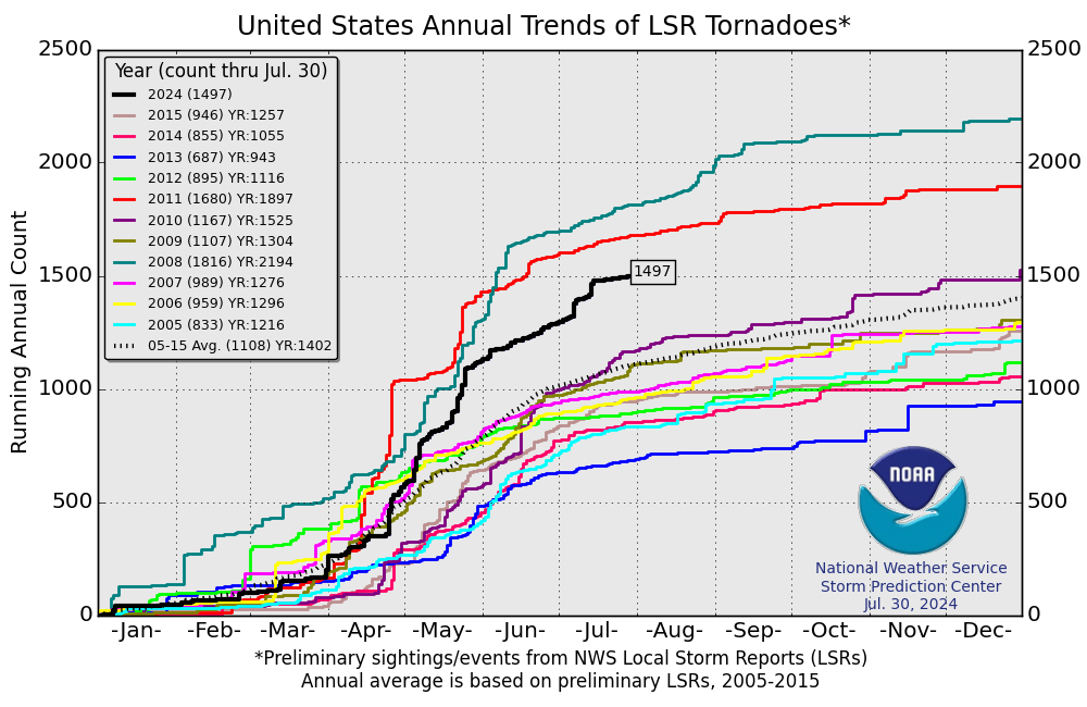
Looks like we are now on a pace to set the all time record for number of tornadoes in CONUS.

We have far surpassed the April record set back in 1974.

1974 had 267; as of 4/26 there were 654!


http://en.wikipedia.org/wiki/Tornadoes_of_2011

http://www.spc.noaa.gov/climo/online/monthly/newm.html

http://www.spc.noaa.gov/climo/online/mo ... mmary.html

http://www.spc.noaa.gov/wcm/


Image

Image
0 likes   

User avatar
GCANE
S2K Supporter
S2K Supporter
Posts: 11453
Joined: Mon Oct 22, 2007 8:03 am

Re: 2011 CONUS Tornado Stats - A Record Setting Pace

#2 Postby GCANE » Wed Apr 27, 2011 8:04 am

Image


April 27, 2011 - MEMPHIS

The outbreak of the latest round of severe storms pounding the south has claimed another life.

The Monday night storms the extended into a violent Tuesday hit the town of Vilonia,

Arkansas the hardest.

The initial death toll of 5 had doubled during the damage assessment yesterday in a combination of tornadoes and flood water.

Northwestern parts of the state had over 15 inches of rain since Easter weekend.

Overnight, another storm rolled through eastern Arkansas and killed a person in their Sharp County home.

The state capital Little Rock was also hit, as a local grocery store had its roof ripped off.

The latest death total is up to 11, with more still missing.

On Tuesday, another 40 tornadoes were reported by the Storm Prediction Center.

The National Weather Service now says 45 tornadoes were reported.

The hardest hit region was once again from East Texas through Arkansas.

Another potential tornado led to damage in central Michigan.

-Examiner


http://www.examiner.com/weather-in-balt ... h-maryland
0 likes   

User avatar
gatorcane
S2K Supporter
S2K Supporter
Posts: 23689
Age: 47
Joined: Sun Mar 13, 2005 3:54 pm
Location: Boca Raton, FL

#3 Postby gatorcane » Wed Apr 27, 2011 9:25 pm

I think one of the contributing factors this year is the duration of above normal temps across the deep south and Gulf of Mexico for much of late March into most of April, which has really warmed the Gulf of Mexico. Those very warm gulf ssts are tapped as vigorous spring-time troughs sweep across the CONUS.
0 likes   

User avatar
GCANE
S2K Supporter
S2K Supporter
Posts: 11453
Joined: Mon Oct 22, 2007 8:03 am

Re: 2011 CONUS Tornado Stats - A Record Setting Pace

#4 Postby GCANE » Thu Apr 28, 2011 4:27 am

April 27 exceeds 74 Super Outbreak:

SPC logged 153 tornadoes.

http://www.spc.noaa.gov/climo/reports/today.html


1974 Super Outbreak was 148.

http://en.wikipedia.org/wiki/Super_Outbreak
0 likes   

User avatar
GCANE
S2K Supporter
S2K Supporter
Posts: 11453
Joined: Mon Oct 22, 2007 8:03 am

Re:

#5 Postby GCANE » Thu Apr 28, 2011 4:31 am

gatorcane wrote:I think one of the contributing factors this year is the duration of above normal temps across the deep south and Gulf of Mexico for much of late March into most of April, which has really warmed the Gulf of Mexico. Those very warm gulf ssts are tapped as vigorous spring-time troughs sweep across the CONUS.


I agree there has been some deep CAPE and LI values that come from air advecting from the GOM into the south.

Also, there seems to be a larger number of negatively tilted shortwaves that help to create high helicity and shear.

Surface lows have not been all that deep. The 4/27 outbreak was only about 996mb.
0 likes   


User avatar
Typhoon_Willie
Category 5
Category 5
Posts: 1042
Joined: Mon Jun 09, 2003 3:19 pm
Location: Greenacres City, Florida

Re: 2011 CONUS Tornado Stats - A Record Setting Pace

#7 Postby Typhoon_Willie » Thu Apr 28, 2011 5:49 am

I wonder if the record amount of tornadoes is a sign of a very busy hurricane season to come. Is there any past data on this?
0 likes   

User avatar
GCANE
S2K Supporter
S2K Supporter
Posts: 11453
Joined: Mon Oct 22, 2007 8:03 am

Re: 2011 CONUS Tornado Stats - A Record Setting Pace

#8 Postby GCANE » Thu Apr 28, 2011 5:54 am

Typhoon_Willie wrote:I wonder if the record amount of tornadoes is a sign of a very busy hurricane season to come. Is there any past data on this?


Not sure. I think some speculate that it could be ENSO related.

I have another hunch. I am thinking it is more to do with ionospheric effects.

It was very interesting that a lot of major metro areas were hit yesterday.

Also there was St Louis in the past week and Raleigh a couple weeks ago.

I am thinking that this effect will also translate for the hurricane season as well with major hits on metro areas.
0 likes   

User avatar
GCANE
S2K Supporter
S2K Supporter
Posts: 11453
Joined: Mon Oct 22, 2007 8:03 am

Re: 2011 CONUS Tornado Stats - A Record Setting Pace

#9 Postby GCANE » Thu Apr 28, 2011 7:24 am

Last edited by GCANE on Sat Apr 30, 2011 7:55 pm, edited 1 time in total.
0 likes   

User avatar
thetruesms
Professional-Met
Professional-Met
Posts: 844
Age: 41
Joined: Thu Aug 16, 2007 1:14 pm
Location: Tallahasee, FL
Contact:

#10 Postby thetruesms » Thu Apr 28, 2011 1:38 pm

Let's not get too ahead of ourselves yet - the official count is never as high as the number of preliminary reports due to duplicates and erroneous reports. The ballpark reduction would take the 165 prelim reports down to 140, which doesn't pass '74. And there's thinking that the 0.85 reduction is not enough because of the increase of reports submitted.
0 likes   

User avatar
Tireman4
S2K Supporter
S2K Supporter
Posts: 5851
Age: 59
Joined: Fri Jun 30, 2006 1:08 pm
Location: Humble, Texas
Contact:

Re:

#11 Postby Tireman4 » Thu Apr 28, 2011 2:35 pm

thetruesms wrote:Let's not get too ahead of ourselves yet - the official count is never as high as the number of preliminary reports due to duplicates and erroneous reports. The ballpark reduction would take the 165 prelim reports down to 140, which doesn't pass '74. And there's thinking that the 0.85 reduction is not enough because of the increase of reports submitted.


But I do think this may rival the '74 Outbreak...come in a close second...
0 likes   

User avatar
thetruesms
Professional-Met
Professional-Met
Posts: 844
Age: 41
Joined: Thu Aug 16, 2007 1:14 pm
Location: Tallahasee, FL
Contact:

#12 Postby thetruesms » Thu Apr 28, 2011 2:40 pm

Yes, whatever the final count ends up being, it will be a truly exceptional outbreak.
0 likes   

RL3AO
Moderator-Pro Met
Moderator-Pro Met
Posts: 16308
Joined: Thu Jun 14, 2007 10:03 pm
Location: NC

#13 Postby RL3AO » Thu Apr 28, 2011 2:59 pm

And lets remember that the Super Outbreak had 24 F4's and 6 F5's.
0 likes   

bob rulz
Category 5
Category 5
Posts: 1703
Age: 35
Joined: Sat Jan 28, 2006 7:30 pm
Location: Salt Lake City, Utah

Re: 2011 CONUS Tornado Stats - A Record Setting Pace

#14 Postby bob rulz » Thu Apr 28, 2011 5:37 pm

In retrospect it's somewhat remarkable that the Super Outbreak didn't kill even more people than it did with 30 tornadoes of F4/F5 intensity. It's far and away the worst tornado outbreak of the modern day, until now, but even this one didn't reach the scope of that one, and probably not even close to the same number of super-intense tornadoes.

Of course, as evidenced by the Tuscaloosa/Birmingham tornado, it only takes 1 tornado to make it historic. It would've been terrible even without that tornado but that single tornado will make it go down in the history books.
0 likes   

User avatar
GCANE
S2K Supporter
S2K Supporter
Posts: 11453
Joined: Mon Oct 22, 2007 8:03 am

Re: 2011 CONUS Tornado Stats - A Record Setting Pace

#15 Postby GCANE » Sat Apr 30, 2011 12:02 pm

Twister outbreak is second deadliest in US history

http://www.msnbc.msn.com/id/42834400/ns ... ?GT1=43001


TUSCALOOSA, Ala. — The death toll from this week's storms rose to 344 Saturday, according to an NBC News count, making the tornado outbreak the second deadliest in U.S. history.

With some estimates putting the number of homes and buildings destroyed close to 10,000, state and federal authorities in the U.S. South were still coming to terms with the scale of the devastation from the country's worst natural catastrophe since Hurricane Katrina in 2005.

In Tuscaloosa, Ala., alone, up to 446 people were still unaccounted for in the city, though Mayor Walt Maddox said many of those reports probably were from people who have since found their loved ones but have not notified authorities.

The number of deaths has now surpassed that of a twister outbreak that hit Alabama in March 1932, killing 332 people.

The largest death toll ever was on March 18, 1925, when 747 people were killed in storms that raged through Missouri, Illinois and Indiana.
0 likes   

RL3AO
Moderator-Pro Met
Moderator-Pro Met
Posts: 16308
Joined: Thu Jun 14, 2007 10:03 pm
Location: NC

Re: 2011 CONUS Tornado Stats - A Record Setting Pace

#16 Postby RL3AO » Sat Apr 30, 2011 12:52 pm

I've always wondered if Dr. Fujita may have overestimated some of those tornadoes. Not doubting the Xenia tornado but 30 violent tornadoes doesnt seem possible.
0 likes   

psyclone
S2K Supporter
S2K Supporter
Posts: 4745
Joined: Wed Aug 24, 2005 9:04 pm
Location: palm harbor fl

#17 Postby psyclone » Sat Apr 30, 2011 1:43 pm

the super outreak's violent tornadoes were spread over a wide area. i think this outbreak would have eclipsed the super outbreak meteorlogically (it already has in terms of death toll) were it not for the late night/early morning convection perhaps limiting the northward transport of high cape air into places like kentucky, eastern indiana, ohio and western pa. those regions were all under the gun the night before but were ultimately exempted. just imagine if things would have ripped loose in those regions...it would have truly been the super outbreak part II. what i find astonishing about this event is the extreme concentration of violent, long track tornadoes in a relatively small area.
0 likes   

User avatar
Extratropical94
Professional-Met
Professional-Met
Posts: 3538
Age: 30
Joined: Wed Oct 20, 2010 6:36 am
Location: Hamburg, Germany
Contact:

#18 Postby Extratropical94 » Sat Apr 30, 2011 3:36 pm

Could somebody explain me please why the SPC change their storm report numbers downwards sometimes?
Earlier today they had 1052 tors including April 29th.
Now they changed it to 1036 reports as of April 30th.

They did the same thing about a week ago, too.
And for hail reports, they decreased it from four thousand and something last week to 2870 now.

I thought that the number of storm reports can't decrease...
0 likes   
54° 11' 59'' N, 9° 9' 20'' E
Boomer Sooner!
Go Broncos! Go Cards! Go Niners!
- Daniel

RL3AO
Moderator-Pro Met
Moderator-Pro Met
Posts: 16308
Joined: Thu Jun 14, 2007 10:03 pm
Location: NC

Re:

#19 Postby RL3AO » Sat Apr 30, 2011 3:38 pm

Extratropical94 wrote:Could somebody explain me please why the SPC change their storm report numbers downwards sometimes?
Earlier today they had 1052 tors including April 29th.
Now they changed it to 1036 reports as of April 30th.

They did the same thing about a week ago, too.
And for hail reports, they decreased it from four thousand and something last week to 2870 now.

I thought that the number of storm reports can't decrease...


It will go down because the same tornado can get reported multiple times by different people.
0 likes   

User avatar
GCANE
S2K Supporter
S2K Supporter
Posts: 11453
Joined: Mon Oct 22, 2007 8:03 am

Re: 2011 CONUS Tornado Stats - A Record Setting Pace

#20 Postby GCANE » Mon May 02, 2011 8:11 am

Got this from Dr Masters blog.
TRMM Precip Radar during the outbreak on Wednesday 4/27.
Incredible supercell tops, usually see these hot towers in TCs when they ramp up to a major.


Image


Still frame from an animation showing the height and extent of the rain columns associated with the thunderstorms that spawned Wednesday's tornadoes.
This data, taken from NASA's TRMM satellite, showed that some of these violent storms reached incredible heights of almost 10.6 miles (17 km.)
Image credit: NASA/SSAI, Hal Pierce
0 likes   


Return to “USA & Caribbean Weather”

Who is online

Users browsing this forum: No registered users and 41 guests