Historic Multi Day Tornado/Flooding Event 4/23-28/2011
Moderator: S2k Moderators
Forum rules

The posts in this forum are NOT official forecast and should not be used as such. They are just the opinion of the poster and may or may not be backed by sound meteorological data. They are NOT endorsed by any professional institution or STORM2K.
-
apocalypt-flyer
- Category 1

- Posts: 468
- Joined: Sat Aug 27, 2005 11:51 am
-
Texas Snowman

- Storm2k Moderator

- Posts: 6197
- Joined: Fri Jan 25, 2008 11:29 am
- Location: Denison, Texas
Re:
Bunkertor wrote:Tusca = Moore
I'm afraid you may be right. Horrifying tornado moving through a heavily populated area. EF5?
0 likes
The above post and any post by Texas Snowman is NOT an official forecast and should not be used as such. It is just the opinion of the poster and may or may not be backed by sound meteorological data. It is NOT endorsed by any professional institution including storm2k.org. For official information, please refer to NWS products.


-
Texas Snowman
- Storm2k Moderator
- Posts: 6197
- Joined: Fri Jan 25, 2008 11:29 am
- Location: Denison, Texas
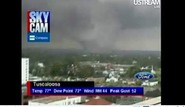
Re: Potential Widespread Flooding/Severe Weather Event 4/23-28
ABC 33/40 reports numerous homes flattened in Tuscaloosa County.
TV station's storm spotter says the Tuscaloosa tornado is one mile wide.
Did it pass through the University of Alabama campus?
TV station's storm spotter says the Tuscaloosa tornado is one mile wide.
Did it pass through the University of Alabama campus?
0 likes
The above post and any post by Texas Snowman is NOT an official forecast and should not be used as such. It is just the opinion of the poster and may or may not be backed by sound meteorological data. It is NOT endorsed by any professional institution including storm2k.org. For official information, please refer to NWS products.
-
wxman57

- Moderator-Pro Met

- Posts: 23175
- Age: 68
- Joined: Sat Jun 21, 2003 8:06 pm
- Location: Houston, TX (southwest)
Re: Potential Widespread Flooding/Severe Weather Event 4/23-28
Just installed a free 21 day demo of GR Analyst 2 (takes seconds):
http://www.grlevelx.com/gr2analyst/
You can create volumetric scans of the tornadic cells in Alabama, like the one below. Seeing some tremendous rotation in some of the cells today. Here's a scan of the tornado near Tuscaloosa, AL:

http://www.grlevelx.com/gr2analyst/
You can create volumetric scans of the tornadic cells in Alabama, like the one below. Seeing some tremendous rotation in some of the cells today. Here's a scan of the tornado near Tuscaloosa, AL:
0 likes

-
Texas Snowman
- Storm2k Moderator
- Posts: 6197
- Joined: Fri Jan 25, 2008 11:29 am
- Location: Denison, Texas
Re: Potential Widespread Flooding/Severe Weather Event 4/23-28
Ham radio report out of Tuscaloosa: destruction at University Mall and at the medical center
0 likes
The above post and any post by Texas Snowman is NOT an official forecast and should not be used as such. It is just the opinion of the poster and may or may not be backed by sound meteorological data. It is NOT endorsed by any professional institution including storm2k.org. For official information, please refer to NWS products.
-
brunota2003

- S2K Supporter

- Posts: 9476
- Age: 35
- Joined: Sat Jul 30, 2005 9:56 pm
- Location: Stanton, KY...formerly Havelock, NC
- Contact:


Re: Potential Widespread Flooding/Severe Weather Event 4/23-28
anyone got a count of how many watches and warnings that have been issued in the last 2 days
0 likes
-
Dave

- Retired Staff

- Posts: 13442
- Age: 75
- Joined: Tue Aug 01, 2006 3:57 pm
- Location: Milan Indiana
- Contact:
JOHNSON IL-WILLIAMSON IL-
527 PM CDT WED APR 27 2011
...A TORNADO WARNING REMAINS IN EFFECT UNTIL 545 PM CDT FOR
WILLIAMSON AND EASTERN JOHNSON COUNTIES IN SOUTHERN ILLINOIS...
AT 522 PM CDT...TRAINED WEATHER SPOTTERS REPORTED A FUNNEL CLOUD 4
TO 5 MILES SOUTH OF MARION. THE LINE OF STORMS PRODUCING THIS FUNNEL
AND POTENTIALLY ADDITIONAL TORNADOES EXTENDS FROM PITTSBURG TO 4
MILES EAST OF VIENNA...IS MOVING NORTHEAST AT 50 MPH.
LOCATIONS IN THE WARNING INCLUDE SIMPSON.
PRECAUTIONARY/PREPAREDNESS ACTIONS...
IN ADDITION TO THE TORNADO...THIS STORM IS CAPABLE OF PRODUCING
LARGE HAIL AND DESTRUCTIVE STRAIGHT LINE WINDS.
&&
LAT...LON 3786 8872 3734 8872 3734 8891 3762 8891
3786 8915
TIME...MOT...LOC 2226Z 244DEG 40KT 3778 8880 3742 8878
0 likes
-
Extratropical94

- Professional-Met

- Posts: 3545
- Age: 31
- Joined: Wed Oct 20, 2010 6:36 am
- Location: Hamburg, Germany
- Contact:
watches:
April 26: 212-224 -> 13 watches
April 27: 225-240 -> 16 watches
29 watches in 2 days
April 26: 212-224 -> 13 watches
April 27: 225-240 -> 16 watches
29 watches in 2 days
0 likes
54° 11' 59'' N, 9° 9' 20'' E
Boomer Sooner!
Go Broncos! Go Cards!
Clinching counties, one at a time: https://mob-rule.com/user-gifs/USA/xtrp94.gif
- Daniel
Boomer Sooner!
Go Broncos! Go Cards!
Clinching counties, one at a time: https://mob-rule.com/user-gifs/USA/xtrp94.gif
- Daniel

-
brunota2003
- S2K Supporter
- Posts: 9476
- Age: 35
- Joined: Sat Jul 30, 2005 9:56 pm
- Location: Stanton, KY...formerly Havelock, NC
- Contact:
Return to “USA & Caribbean Weather”
Who is online
Users browsing this forum: HockeyTx82 and 158 guests