Historic Multi Day Tornado/Flooding Event 4/23-28/2011
Moderator: S2k Moderators
Forum rules

The posts in this forum are NOT official forecast and should not be used as such. They are just the opinion of the poster and may or may not be backed by sound meteorological data. They are NOT endorsed by any professional institution or STORM2K.

-
Texas Snowman

- Storm2k Moderator

- Posts: 6197
- Joined: Fri Jan 25, 2008 11:29 am
- Location: Denison, Texas
Re: Potential Widespread Flooding/Severe Weather Event 4/23-28
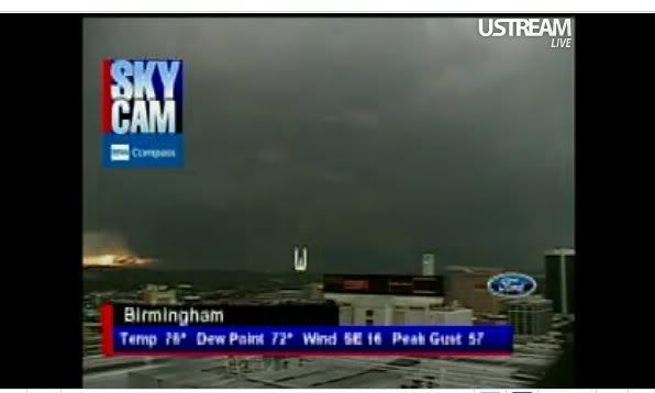
I've never witnessed a tornado as wide as this one. It is barrelling down I-20 towards downtown Birmingham.
Surreal...
No telling how many fatalities this thing has/will cause.
Surreal...
No telling how many fatalities this thing has/will cause.
0 likes
The above post and any post by Texas Snowman is NOT an official forecast and should not be used as such. It is just the opinion of the poster and may or may not be backed by sound meteorological data. It is NOT endorsed by any professional institution including storm2k.org. For official information, please refer to NWS products.
-
brunota2003

- S2K Supporter

- Posts: 9476
- Age: 35
- Joined: Sat Jul 30, 2005 9:56 pm
- Location: Stanton, KY...formerly Havelock, NC
- Contact:
-
Texas Snowman
- Storm2k Moderator
- Posts: 6197
- Joined: Fri Jan 25, 2008 11:29 am
- Location: Denison, Texas
Re:
brunota2003 wrote:TWC is saying they think the mesocyclone is almost all the way down to the ground!
It sure looks that way. This thing may be two miles wide.
0 likes
The above post and any post by Texas Snowman is NOT an official forecast and should not be used as such. It is just the opinion of the poster and may or may not be backed by sound meteorological data. It is NOT endorsed by any professional institution including storm2k.org. For official information, please refer to NWS products.
-
brunota2003
- S2K Supporter
- Posts: 9476
- Age: 35
- Joined: Sat Jul 30, 2005 9:56 pm
- Location: Stanton, KY...formerly Havelock, NC
- Contact:
Re: Potential Widespread Flooding/Severe Weather Event 4/23-28
ALC073-117-272330-
/O.CON.KBMX.TO.W.0114.000000T0000Z-110427T2330Z/
SHELBY AL-JEFFERSON AL-
600 PM CDT WED APR 27 2011
...A TORNADO WARNING REMAINS IN EFFECT FOR JEFFERSON AND NORTHEASTERN
SHELBY COUNTIES UNTIL 630 PM CDT...
...TORNADO EMERGENCY CONTINUES FOR BIRMINGHAM...MINOR...DOWNTOWN
BIRMINGHAM...THE FAIRGROUNDS...BIRMINGHAM SHUTTLESWORTH AIRPORT......
AT 600 PM CDT...NATIONAL WEATHER SERVICE DOPPLER RADAR AND STORM
SPOTTERS WERE TRACKING A LARGE WEDGE AND EXTREMELY DANGEROUS
TORNADO. THIS TORNADO WAS LOCATED NEAR MINOR...OR NEAR
FAIRFIELD...MOVING NORTHEAST AT 60 MPH.
LOCATIONS IMPACTED INCLUDE...
BIRMINGHAM...MOUNTAIN BROOK...FULTONDALE...IRONDALE...GARDENDALE...
LEEDS...PINSON-CLAY-CHALKVILLE...TRUSSVILLE...SAMFORD UNIVERSITY
AND U.A.B. CAMPUS.
THIS INCLUDES...
INTERSTATE 65 EXIT NUMBERS 250 THROUGH 282...
INTERSTATE 459 EXIT NUMBERS 17 THROUGH 33...
US 78 EXIT NUMBERS 81 THROUGH 91...
INTERSTATE 20 EXIT NUMBERS 113 THROUGH 140...
INTERSTATE 59 EXIT NUMBERS 130 THROUGH 143...
0 likes
-
AdamFirst

- S2K Supporter
- Posts: 2490
- Age: 36
- Joined: Thu Aug 14, 2008 10:54 am
- Location: Port Saint Lucie, FL
Re: Potential Widespread Flooding/Severe Weather Event 4/23-28

That darkness on the horizon is the wedge tornado.
0 likes
Dolphins Marlins Canes Golden Panthers HEAT
Andrew 1992 - Irene 1999 - Frances 2004 - Jeanne 2004 - Wilma 2005 - Fay 2008 - Isaac 2012 - Matthew 2016 - Irma 2017 - Dorian 2019 - Ian 2022 - Nicole 2022 - Milton 2024
Andrew 1992 - Irene 1999 - Frances 2004 - Jeanne 2004 - Wilma 2005 - Fay 2008 - Isaac 2012 - Matthew 2016 - Irma 2017 - Dorian 2019 - Ian 2022 - Nicole 2022 - Milton 2024


-
Texas Snowman
- Storm2k Moderator
- Posts: 6197
- Joined: Fri Jan 25, 2008 11:29 am
- Location: Denison, Texas
Re: Potential Widespread Flooding/Severe Weather Event 4/23-28
EDIT: In answer to the width:
Dr. Greg Forbes - circulation 1 1/2 mile wide.
CBS 42: spotters saying EF4 or EF5 damage.
Dr. Greg Forbes - circulation 1 1/2 mile wide.
CBS 42: spotters saying EF4 or EF5 damage.
0 likes
The above post and any post by Texas Snowman is NOT an official forecast and should not be used as such. It is just the opinion of the poster and may or may not be backed by sound meteorological data. It is NOT endorsed by any professional institution including storm2k.org. For official information, please refer to NWS products.
-
Texas Snowman
- Storm2k Moderator
- Posts: 6197
- Joined: Fri Jan 25, 2008 11:29 am
- Location: Denison, Texas
Folks, this is a historic tornado in progress.
Who knows, perhaps the worst tornado in modern history?
NW part of downtown Birmingham - emergency management officials say buildings are MISSING!!!!
Who knows, perhaps the worst tornado in modern history?
NW part of downtown Birmingham - emergency management officials say buildings are MISSING!!!!
0 likes
The above post and any post by Texas Snowman is NOT an official forecast and should not be used as such. It is just the opinion of the poster and may or may not be backed by sound meteorological data. It is NOT endorsed by any professional institution including storm2k.org. For official information, please refer to NWS products.
-
Dave

- Retired Staff

- Posts: 13442
- Age: 75
- Joined: Tue Aug 01, 2006 3:57 pm
- Location: Milan Indiana
- Contact:
BULLETIN - EAS ACTIVATION REQUESTED
TORNADO WARNING
NATIONAL WEATHER SERVICE INDIANAPOLIS IN
705 PM EDT WED APR 27 2011
THE NATIONAL WEATHER SERVICE IN INDIANAPOLIS HAS ISSUED A
* TORNADO WARNING FOR...
SOUTHEASTERN BOONE COUNTY IN CENTRAL INDIANA...
NORTHERN HENDRICKS COUNTY IN CENTRAL INDIANA...
NORTHWESTERN MARION COUNTY IN CENTRAL INDIANA...NW Indianapolis
* UNTIL 745 PM EDT
* AT 706 PM EDT...NATIONAL WEATHER SERVICE DOPPLER RADAR INDICATED A
SEVERE THUNDERSTORM CAPABLE OF PRODUCING A TORNADO. THIS DANGEROUS
STORM WAS LOCATED NEAR BROWNSBURG...OR 18 MILES WEST OF
INDIANAPOLIS...AND MOVING NORTHEAST AT 15 MPH.
* THIS DANGEROUS STORM WILL BE NEAR...
LIZTON AROUND 710 PM EDT...
PITTSBORO...BROWNSBURG AND CLERMONT AROUND 715 PM EDT...
EAGLE CREEK RESERVOIR AROUND 725 PM EDT...
WHITESTOWN AND ZIONSVILLE AROUND 745 PM EDT...
THIS INCLUDES INTERSTATE 65 BETWEEN MILE MARKERS 122 AND 138.
THIS INCLUDES INTERSTATE 74 BETWEEN MILE MARKERS 57 AND 71.
0 likes
-
Texas Snowman
- Storm2k Moderator
- Posts: 6197
- Joined: Fri Jan 25, 2008 11:29 am
- Location: Denison, Texas
Re: Potential Widespread Flooding/Severe Weather Event 4/23-28
Tuscaloosa Hospital has gone into "Disaster Mode" - to receive mass casualties.
0 likes
The above post and any post by Texas Snowman is NOT an official forecast and should not be used as such. It is just the opinion of the poster and may or may not be backed by sound meteorological data. It is NOT endorsed by any professional institution including storm2k.org. For official information, please refer to NWS products.
-
AdamFirst
- S2K Supporter
- Posts: 2490
- Age: 36
- Joined: Thu Aug 14, 2008 10:54 am
- Location: Port Saint Lucie, FL
Re: Potential Widespread Flooding/Severe Weather Event 4/23-28

Looking north towards Birmingham Airport
0 likes
Dolphins Marlins Canes Golden Panthers HEAT
Andrew 1992 - Irene 1999 - Frances 2004 - Jeanne 2004 - Wilma 2005 - Fay 2008 - Isaac 2012 - Matthew 2016 - Irma 2017 - Dorian 2019 - Ian 2022 - Nicole 2022 - Milton 2024
Andrew 1992 - Irene 1999 - Frances 2004 - Jeanne 2004 - Wilma 2005 - Fay 2008 - Isaac 2012 - Matthew 2016 - Irma 2017 - Dorian 2019 - Ian 2022 - Nicole 2022 - Milton 2024
-
Texas Snowman
- Storm2k Moderator
- Posts: 6197
- Joined: Fri Jan 25, 2008 11:29 am
- Location: Denison, Texas
Re: Potential Widespread Flooding/Severe Weather Event 4/23-28
Tuscaloosa Chaser via Twitter: "It looks like we got hit by a bomb."
Also via Twitter: chasers in Tuscaloosa say EF4 to EF5 damage.
Also via Twitter: chasers in Tuscaloosa say EF4 to EF5 damage.
0 likes
The above post and any post by Texas Snowman is NOT an official forecast and should not be used as such. It is just the opinion of the poster and may or may not be backed by sound meteorological data. It is NOT endorsed by any professional institution including storm2k.org. For official information, please refer to NWS products.
-
Texas Snowman
- Storm2k Moderator
- Posts: 6197
- Joined: Fri Jan 25, 2008 11:29 am
- Location: Denison, Texas
Re: Potential Widespread Flooding/Severe Weather Event 4/23-28
David Neal, reporter/chaser for CBS 42: "I can't describe the damage I'm seeing. There's really not much left."
0 likes
The above post and any post by Texas Snowman is NOT an official forecast and should not be used as such. It is just the opinion of the poster and may or may not be backed by sound meteorological data. It is NOT endorsed by any professional institution including storm2k.org. For official information, please refer to NWS products.
-
Texas Snowman
- Storm2k Moderator
- Posts: 6197
- Joined: Fri Jan 25, 2008 11:29 am
- Location: Denison, Texas
Re:
Bunkertor wrote:high should be extended to TN
Absolutely...
0 likes
The above post and any post by Texas Snowman is NOT an official forecast and should not be used as such. It is just the opinion of the poster and may or may not be backed by sound meteorological data. It is NOT endorsed by any professional institution including storm2k.org. For official information, please refer to NWS products.
Return to “USA & Caribbean Weather”
Who is online
Users browsing this forum: Cpv17 and 138 guests