http://www.semissourian.com/story/1721968.html
http://www.semissourian.com/story/1721830.html
Wow, Cairo Illinois at confluence of Mississippi and Ohio, set to break record flood mark. Cairo surrounded by two rivers and swampland, protected by only levies during flooding. The old plan, which happened once, was blow a levee on the Missouri side and flood a bunch of farmland to save bustling Cairo, in those days a really big, important railroad city. Now it's a half-dead unimportant city, and the farmland in question is some of the richest-producing in the world. My grandpa's family owned land which got flooded in the 20's when they blew the levee, and it buried their farm with 12-15 ft of sand. They abandoned their land, lost everything. Unloaded a few things into a boat from the attic window, my great-grandma's sewing machine, etc.!
The explosives are moving up river on a barge to arrive today. The people of Cairo being asked to voluntarily evacuate. The Governor of Missouri has filed a lawsuit to stop the Corps. The Corps has postponed their decision, for now. A great story building...
2011 Historic River Floods & CorpEng management
Moderator: S2k Moderators
Forum rules

The posts in this forum are NOT official forecast and should not be used as such. They are just the opinion of the poster and may or may not be backed by sound meteorological data. They are NOT endorsed by any professional institution or STORM2K.
-
bvigal

- S2K Supporter

- Posts: 2276
- Joined: Sun Jul 24, 2005 8:49 am
- Location: British Virgin Islands
- Contact:
2011 Historic River Floods & CorpEng management
Last edited by bvigal on Tue May 24, 2011 8:34 am, edited 4 times in total.
0 likes
-
bvigal
- S2K Supporter
- Posts: 2276
- Joined: Sun Jul 24, 2005 8:49 am
- Location: British Virgin Islands
- Contact:
Re: Citizens battle Corp of Engineers history repeated
Been watching this story develop for days. It's getting really close now.
http://www.semissourian.com/story/1723455.html
General orders pipes at Bird Point levee loaded with blasting agent
(between lightning storms tonight)
http://www.nytimes.com/2011/05/02/us/02levee.html?_r=1
Plan to Breach Levee in Missouri Advances as a Storm Brews
http://www.semissourian.com/story/1723460.html
Supreme Court denies request to stop levee breach
Thankfully, they did order mandatory evacuation of Cairo yesterday. It is completely surrounded by levees holding back like 12ft of water. They have what the Corp of Engineers official called the "biggest sand boil I've ever seen". The river is over historic crest, and what's unusual is for both rivers to be so high simultaneously. More rain today. Rain on Tennessee and northern Alabama also flows north into Ohio River via the Tennessee and Cumberland drainages, where lakes are full.
The biggest safety concern is whether the backup levee, untested for decades, will hold all that water. If it gives way, will flood most of Missouri bootheel.
0 likes

-
WeatherGuesser
- Category 5

- Posts: 2672
- Joined: Tue Jun 29, 2010 6:46 am
This ominous development prompted Maj. Gen. Michael Walsh, president of the Mississippi River Commission, to order several barges into place at 3 p.m. to begin pumping explosive slurry into a levee near where the two rivers meet. This is all in preparation -- if the decision is made -- to blow up the Birds Point-New Madrid levee and potentially flood 130,000 acres of Missouri farmland, in part to save the town of Cairo, Illinois.
At 8 p.m., the water levels on the Ohio River outside Cairo had reached 60.27 feet -- well above the flood stage of 40 feet -- according to the National Weather Service. And, boosted by more rain, the forecast calls for a continued rise to as high as 61.5 feet by Tuesday afternoon.
"This is the largest flood that we have ever seen in our lifetimes," Walsh said.
The U.S. Supreme Court refused Sunday to block any plan to intentionally breach the levee. Supreme Court Justice Samuel Alito ruled against Missouri -- effectively giving Walsh the authority to execute on the levee-breach plan.
http://www.cnn.com/2011/US/05/01/missou ... tml?hpt=T2
Our area is about 12' above Flood Stage and about a foot above the previous record.
0 likes
-
WeatherGuesser
- Category 5
- Posts: 2672
- Joined: Tue Jun 29, 2010 6:46 am
Re: Citizens battle Corp of Engineers history repeated
I'm not particularly fond of the color purple right now.

0 likes

Re: Citizens battle Corp of Engineers history repeated
A lot of speculation this could trigger an earthquake.
This is right on the New Madrid fault.
There has been a swarm going on in Arkansas for the last 4 months.
This is right on the New Madrid fault.
There has been a swarm going on in Arkansas for the last 4 months.
0 likes
-
bvigal
- S2K Supporter
- Posts: 2276
- Joined: Sun Jul 24, 2005 8:49 am
- Location: British Virgin Islands
- Contact:
Re: Citizens battle Corp of Engineers history repeated
I don't think the amount needed to blow open an earth levee is going to effect the NM fault.
What is of more concern is the backup levee, WILL IT HOLD? It's going to get hit quickly with lots of water, not a slow rise, and it's untested with a load since the last blow in the 30's.
This is a very historic situation, unprecendented. This is the 6th "100-year flood" on Mississippi since 1973, 3rd "200yr" (happens only once in 200 years). In fact, does ACorps and FEMA even use that terminology any more? The reason I know is, at Cape Girardeau this morning the Mississippi 46.17ft is the 4th highest level of all time. 2 below that, 45.5ft in 1973 was called a 100-year flood.
Historical Crests
(1) 48.49 ft on 08/08/1993
(2) 47.00 ft on 05/24/1995
(3) 46.90 ft on 08/03/1993
today 46.17ft
(4) 45.70 ft on 05/18/2002
(5) 45.50 ft on 05/01/1973
But in all those, I never recall having 18" of rain in a week all over the area and both Mississippi and Cairo in record flooding, all of TN river drainage (N Alabama, Mississippi) and the big lakes (Kentucky, Barkley, etc.) all at capacity. Upstream in the Missouri River watershed, some parts of snowpack (Yellowstone, Montana) have over 30" of water and it's late in the year for that kind of pack.

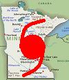
Map is from MODOT (Missouri Department Transportation) showing roads closed NOW due to flooding. I've drawn in, very rough and unscientifically, the levees in question, and all the 'bottomland' that could potentially be flooded if the backup levee breaks open. The reason for the areas north of highway 60, major roads are levees, so N/S I-55 has some sandbags in one spot, and real problems with E/W highway 60, you'll note all the flooded areas (closed roads) already along routh 25 N/S from Scott County west to Wayne Co, from backup up rainwater, etc, inside big drainage system levees, can't drain out the Diversion Channel (big ditch) because the Mississippi is too high. Many simple earth levees have been holding water for a couple of weeks already.
What is of more concern is the backup levee, WILL IT HOLD? It's going to get hit quickly with lots of water, not a slow rise, and it's untested with a load since the last blow in the 30's.
This is a very historic situation, unprecendented. This is the 6th "100-year flood" on Mississippi since 1973, 3rd "200yr" (happens only once in 200 years). In fact, does ACorps and FEMA even use that terminology any more? The reason I know is, at Cape Girardeau this morning the Mississippi 46.17ft is the 4th highest level of all time. 2 below that, 45.5ft in 1973 was called a 100-year flood.
Historical Crests
(1) 48.49 ft on 08/08/1993
(2) 47.00 ft on 05/24/1995
(3) 46.90 ft on 08/03/1993
today 46.17ft
(4) 45.70 ft on 05/18/2002
(5) 45.50 ft on 05/01/1973
But in all those, I never recall having 18" of rain in a week all over the area and both Mississippi and Cairo in record flooding, all of TN river drainage (N Alabama, Mississippi) and the big lakes (Kentucky, Barkley, etc.) all at capacity. Upstream in the Missouri River watershed, some parts of snowpack (Yellowstone, Montana) have over 30" of water and it's late in the year for that kind of pack.
Map is from MODOT (Missouri Department Transportation) showing roads closed NOW due to flooding. I've drawn in, very rough and unscientifically, the levees in question, and all the 'bottomland' that could potentially be flooded if the backup levee breaks open. The reason for the areas north of highway 60, major roads are levees, so N/S I-55 has some sandbags in one spot, and real problems with E/W highway 60, you'll note all the flooded areas (closed roads) already along routh 25 N/S from Scott County west to Wayne Co, from backup up rainwater, etc, inside big drainage system levees, can't drain out the Diversion Channel (big ditch) because the Mississippi is too high. Many simple earth levees have been holding water for a couple of weeks already.
0 likes
-
bvigal
- S2K Supporter
- Posts: 2276
- Joined: Sun Jul 24, 2005 8:49 am
- Location: British Virgin Islands
- Contact:
Re: Corp of Engineers finishing explosives to blow levee
River at Cairo goes over 61 feet; Corps still loading explosives
http://www.semissourian.com/story/1723568.html
http://www.semissourian.com/story/1723568.html
0 likes
Re: Corp of Engineers finishing explosives to blow levee
I think the issue is the sudden weight of the water that could effect the fault system.
It is common knowledge that when water fills up behind a new dam, the chances for a quake increases.
That is why they fill reserviors up slowly.
It is common knowledge that when water fills up behind a new dam, the chances for a quake increases.
That is why they fill reserviors up slowly.
0 likes
-
bvigal
- S2K Supporter
- Posts: 2276
- Joined: Sun Jul 24, 2005 8:49 am
- Location: British Virgin Islands
- Contact:
Re: Corp of Engineers finishing explosives to blow levee
Hmm, well that's a very sobering bit of info, as if the situation weren't bad enough! {{{shiver}}}
checkout this AMAZING pic of the water topping damn at Lake Wappepello! http://kfvs12.images.worldnow.com/image ... 21_BG4.jpg
Just found this on NWS-PADUCAH:
...RAINFALL TOTALS FOR APRIL 21 THROUGH APRIL 28...
THE FOLLOWING ARE RAINFALL TOTALS ACROSS THE REGION BEGINNING LAST
THURSDAY EVENING...APRIL 21 THROUGH THIS MORNING...THURSDAY APRIL
28.
AIRPORTS
POPLAR BLUFF, MO 16.47
CAPE GIRARDEAU 14.96
PADUCAH, KY 10.61
CARBONDALE, IL 10.58
EVANSVILLE, IN 7.22
MISSOURI COOPERATIVE OBSERVERS...
JACKSON 13.22 MARBLE HILL 12.72
MISSOURI AUTOMATED GAGES...
BIRDS POINT 9.71 CAPE GIRARDEAU 10.92 CLEARWATER DAM 12.88
COMMERCE 12.16 DONIPHAN RAWS 11.45 DONIPHAN (RVR) 9.42
FISK 15.15 GREENVILLE 12.83 MENFRO 10.66
PATTERSON 11.92 PRICE LANDING 9.94 POPLAR BLUFF 16.28
WAPPAPELLO DAM 12.80
Don't know how much they all had last night/today, many were over 2.5" at midnight.
0 likes
Re: Corp of Engineers finishing explosives to blow levee
Looks like Maj Gen Walsh will make an announcement at 5PM local time.
0 likes
-
bvigal
- S2K Supporter
- Posts: 2276
- Joined: Sun Jul 24, 2005 8:49 am
- Location: British Virgin Islands
- Contact:
Re: Corp of Engineers finishing explosives to blow levee
they are going to blow (no surprise)
0 likes
Re: Corp of Engineers finishing explosives to blow levee
bvigal wrote:they are going to blow (no surprise)
Between 9PM and Midnight.
http://www.facebook.com/pages/Birds-Poi ... 8681323357
0 likes
-
OverlandHurricane
- S2K Supporter
- Posts: 58
- Joined: Thu Aug 28, 2008 4:50 pm
- Location: Minnesota
Re: Corp of Engineers finishing explosives to blow levee
The term "100-year" and "200-year" are something of a misnomer. What a 100-year flood means is the flood whose probability to occur every year is 1 in 100. The computed return period on a 100-year flood is around 33 years, give or take.
0 likes
Re: Corp of Engineers finishing explosives to blow levee
"We executed the plan and it performed as expected," said Col. Vernie Reichling, Commander of the Corps' Memphis District. "We are now moving to the next steps, which are opening the two outflow crevasses at the southern end of the floodway. We are transferring our command and control to New Madrid."
http://www.facebook.com/photo.php?fbid= ... =1&theater
http://www.facebook.com/photo.php?fbid= ... =1&theater
0 likes
Re: Corp of Engineers finishing explosives to blow levee
[youtube]http://www.youtube.com/watch?v=NOPqnjPF3Vc&feature=channel_video_title[/youtube]
0 likes
-
bvigal
- S2K Supporter
- Posts: 2276
- Joined: Sun Jul 24, 2005 8:49 am
- Location: British Virgin Islands
- Contact:
Re: Corp of Engineers finishing explosives to blow levee
OverlandHurricane wrote:The term "100-year" and "200-year" are something of a misnomer. What a 100-year flood means is the flood whose probability to occur every year is 1 in 100. The computed return period on a 100-year flood is around 33 years, give or take.
Thanks for explaining what this means! (I always wondered)
0 likes
-
bvigal
- S2K Supporter
- Posts: 2276
- Joined: Sun Jul 24, 2005 8:49 am
- Location: British Virgin Islands
- Contact:
Re: Corp of Engineers finishing explosives to blow levee
GCANE wrote:http://www.youtube.com/watch?v=NOPqnjPF3Vc&feature=channel_video_title
Too cool!!!! Thanks for finding & posting this, GCANE!
0 likes
Re: Corp of Engineers blow levee - video
http://www2.mvr.usace.army.mil/WaterCon ... 1&d=1&dt=S
Gage Update: Cairo gage was at 61.72ft at 10:00 pm last night, before the Bird's Point blast took place, as of 8:00 am reading it was down to 60.51ft.
Engineers in the field are currently meeting to discuss the next steps forward, including second, smaller, blast operation.
Gage Update: Cairo gage was at 61.72ft at 10:00 pm last night, before the Bird's Point blast took place, as of 8:00 am reading it was down to 60.51ft.
Engineers in the field are currently meeting to discuss the next steps forward, including second, smaller, blast operation.
0 likes
Re: Corp of Engineers blow levee - video
Here's a video of second detonation
[youtube]http://www.youtube.com/watch?v=vQUvHu1Ttmc&feature=player_embedded[/youtube]
[youtube]http://www.youtube.com/watch?v=vQUvHu1Ttmc&feature=player_embedded[/youtube]
0 likes
Return to “USA & Caribbean Weather”
Who is online
Users browsing this forum: No registered users and 114 guests