Jim Lushine's Dry SFL May Theory And Hurricanes!

This is the general tropical discussion area. Anyone can take their shot at predicting a storms path.

Moderator: S2k Moderators

Forum rules

The posts in this forum are NOT official forecasts and should not be used as such. They are just the opinion of the poster and may or may not be backed by sound meteorological data. They are NOT endorsed by any professional institution or STORM2K. For official information, please refer to products from the National Hurricane Center and National Weather Service.

Help Support Storm2K
Message
Author
User avatar
Blown Away
S2K Supporter
S2K Supporter
Posts: 10147
Joined: Wed May 26, 2004 6:17 am

Jim Lushine's Dry SFL May Theory And Hurricanes!

#1 Postby Blown Away » Tue May 10, 2011 11:59 am

Image
Article to explain Jim Lushine's theory:
http://www.insurancejournal.com/news/so ... tm?print=1

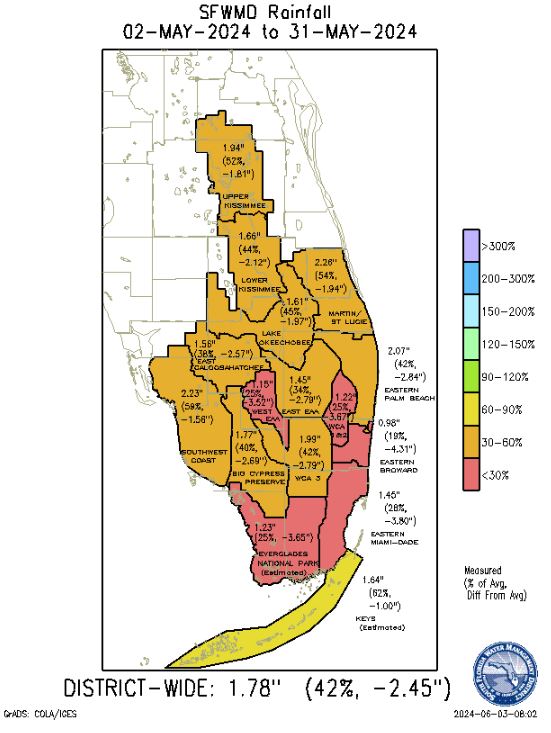
Well it's June and SFL had a very dry May and it's time for me to BUMP this post about Jim Lushine's theory. I know it's not hardcore science, but it is an interesting theory for those of us who follow SFL hurricane history. Years ago I emailed Robert Molleda from the Miami NWS about this theory and here is some information he provided to me:
Per Mr. Molleda:
(1) Jim Lushine used rainfall data from Miami, Ft Lauderdale, and Palm Beach International Airports for his study. (2) Jim Lushine told him that rain amounts favorable for SFL hurricanes were either one or two standard deviations below average, or something around 1” for the month of May. (3) Robert said there have been correlation studies and these studies couldn’t come up with a strong correlation between dry Mays and SFL rainfall. Thus, they discounted this theory until they can do a more thorough analysis area wide.


LUSHINE LINE MAY HINT IF STORM WILL HIT
Palm Beach Post, Jun 8, 2004 | by ELIOT KLEINBERG Palm Beach
Hurricane groupies now have the Lushine Line, an imaginary boundary in the ocean that might foretell whether major storms will strike South Florida.

The line, running due north of the Dominican Republic's east coast, along longitude 68 degrees west from latitude 19 to 26 degrees north, was developed by Jim Lushine, meteorologist for the National Weather Service's Miami office.

Since 1851, 14 "major hurricanes" - with sustained winds of at least 111 mph - are recorded to have struck South Florida, from Jupiter to Homestead and from the Naples area south. Of the 14, a dozen went through the line, Lushine said.

"It's an area you really watch for," Lushine said last week at the South Florida Hurricane Conference in Fort Lauderdale.

But Lushine noted that such exercises always have caveats. He said 140 systems of at least tropical-storm strength have crossed the line, and only 12 struck South Florida as major hurricanes. And two major hurricanes struck South Florida without crossing the line, he said. "It's not that it can't happen because Lushine said it has to cross the line," he said.

There's some obvious and simple logic behind Lushine's method.
All 12 of the 14 major hurricanes that crossed the line and struck South Florida were "Cape Verde" storms, named for the island chain off Africa's west coast where great storms form, then grow as they cross thousands of miles of warm Atlantic waters.

Storms passing north of the line tend to make that historical curve away from land, where most die in the open ocean. Those passing south of the line do one of two things.

They stay in a western path that takes them south of the peninsula, then into the Gulf of Mexico, or they fall victim to the high ground of Cuba and Hispaniola, which tear up a hurricane's circulation like a crowbar in the spokes of a bicycle wheel.

The two major storms that failed to cross the line but still struck the peninsula came in 1910 and 1950. Both were late-season storms that sprang up in the Caribbean and struck from the south.

The northernmost of the 12 to cross the line was Andrew, crossing at about 25.5 degrees north latitude. The southernmost, crossing at about 19 degrees north, was the 1928 Lake Okeechobee hurricane.
Lushine also theorizes a connection between dry Mays and hurricanes striking Florida.

Since 1912, 16 hurricanes have affected the Miami-Dade, Broward and Palm Beach County region. The average of May rainfall totals recorded at the three major airports in those counties was below normal in years when 15 of those storms struck, the exception being 1964 (Cleo).

Last month, Lushine said, was the 13th-driest May on record. Eight of the 12 driest Mays produced a tropical storm or hurricane that struck the three-county region. Six of those Mays led to hurricanes, with five of those becoming major hurricanes. The driest May on record was 1965, when Betsy struck; the second-driest was 1992, the year of Andrew.

Lushine is retiring after 42 years in the business, 33 of them at the Miami office. This will be his last hurricane season.
"I hope," he said, "it goes out with a whimper and not a bang."

- eliot_kleinberg@pbpost.com
Copyright 2004
Last edited by Blown Away on Mon Jun 03, 2024 7:32 am, edited 5 times in total.
0 likes   
Hurricane Eye Experience: David 79, Irene 99, Frances 04, Jeanne 04, Wilma 05... EYE COMING MY WAY IN 2024…
Hurricane Brush Experience: Andrew 92, Erin 95, Floyd 99, Matthew 16, Irma 17, Ian 22, Nicole 22…

User avatar
AJC3
Admin
Admin
Posts: 3999
Age: 61
Joined: Tue Aug 31, 2004 7:04 pm
Location: Ballston Spa, New York
Contact:

#2 Postby AJC3 » Tue May 10, 2011 1:12 pm

This doesn't seem to hold much water (figuratively speaking). I'd chalk it up to a statistical anomaly due to a small sample size.

viewtopic.php?f=31&t=107888
viewtopic.php?f=31&t=101251
viewtopic.php?f=31&t=100913
viewtopic.php?f=31&t=83665
0 likes   

User avatar
Blown Away
S2K Supporter
S2K Supporter
Posts: 10147
Joined: Wed May 26, 2004 6:17 am

Re: Jim Lushine's Dry SFL May Theory And Hurricanes!

#3 Postby Blown Away » Tue May 10, 2011 1:16 pm

Come on, it's May and little to talk about. :D
0 likes   
Hurricane Eye Experience: David 79, Irene 99, Frances 04, Jeanne 04, Wilma 05... EYE COMING MY WAY IN 2024…
Hurricane Brush Experience: Andrew 92, Erin 95, Floyd 99, Matthew 16, Irma 17, Ian 22, Nicole 22…

User avatar
Nimbus
Category 5
Category 5
Posts: 5303
Joined: Mon Jul 19, 2004 10:54 am

Re: Jim Lushine's Dry SFL May Theory And Hurricanes!

#4 Postby Nimbus » Tue May 10, 2011 1:29 pm

We are talking about 15 out of 16 Major hurricanes since 1912 that struck South Florida in years that had a substantially dry May. Wish we could refine his theory a little further.

Obviously the Lushine line theory is a subset of more easily understood Climo modeling.

Similarly dry Mays in South Florida probably are the result of a larger pattern that favors a Bermuda high with low shear over the Bahamas later in the season. Too bad the kids doing computer modeling these days can't keep up with this old timer. I'm sure we will be watching 100's of pages of model runs again this summer spinning up ghost storms and ignoring actual cyclogenesis.

How much have the computer models actually improved in the last 30 years?
0 likes   

User avatar
AJC3
Admin
Admin
Posts: 3999
Age: 61
Joined: Tue Aug 31, 2004 7:04 pm
Location: Ballston Spa, New York
Contact:

#5 Postby AJC3 » Tue May 10, 2011 1:30 pm

Blown Away wrote:Come on, it's May and little to talk about. :D


Hey, not trying to rain on your parade...by all means discuss away! I just added the links not to discourage discussion, but for reference for those who want to see what's been said in the past.

Still, the correlation for Jim's rule of thumb is not statistically significant to be used as a robust forecast tool. Both 2008 and 2010 bore that out.
0 likes   

Frank2
Category 5
Category 5
Posts: 4061
Joined: Mon Jul 25, 2005 12:47 pm

Re: Jim Lushine's Dry SFL May Theory And Hurricanes!

#6 Postby Frank2 » Wed May 11, 2011 10:11 am

Jim was a great guy to work for though so far this year the weather in the tropics have shown consistent strong shear - from everything I've read over the past 5 or 10 years, the one theory that seems to hold the most rain water (or lack of) is the theory that the increase in global air temperatures also increases shear - the incredible tornado outbreaks have also been caused, at least in part, by increased shear - though as we know shear in the tropics has a negative effect, and is probably why the educated guesses for this year are for an average season, so a dry May might have more to do with Florida being in between the droughts of the Caribbean and Texas than anything else...

Frank2
0 likes   

User avatar
Nimbus
Category 5
Category 5
Posts: 5303
Joined: Mon Jul 19, 2004 10:54 am

Re:

#7 Postby Nimbus » Wed May 11, 2011 3:04 pm

AJC3 wrote:
Blown Away wrote:Come on, it's May and little to talk about. :D


Hey, not trying to rain on your parade...by all means discuss away! I just added the links not to discourage discussion, but for reference for those who want to see what's been said in the past.

Still, the correlation for Jim's rule of thumb is not statistically significant to be used as a robust forecast tool. Both 2008 and 2010 bore that out.


If the chances of a major hurricane making landfall in South Florida is 10% in any given year than I doubt a dry May would increase those chances above 11% or a wet May reduce the odds to 9%.

The estimated odds for a major hurricane making landfall in South Florida have been coming down over the years anyways. From about 15% in 1950 to 11.1% when we factor in the more recent quiet historical data.

I used to do insurance experience modeling for hurricanes years ago, even a 1% probability difference for a given area can make a big difference for underwriting purposes.
0 likes   

Frank2
Category 5
Category 5
Posts: 4061
Joined: Mon Jul 25, 2005 12:47 pm

Re: Jim Lushine's Dry SFL May Theory And Hurricanes!

#8 Postby Frank2 » Thu May 12, 2011 7:56 am

True, Nimbus, though as we know the 2004 and 2005 seasons were extremely busy for Florida, so you might get some who'd disagree - and the folks at the NHC would strongly disagree, saying that Andrew was an example of a quiet season that will always be remembered for it's one landfalling hurricane, though my own feeling (just based on living here for decades) is that it's true that the overall frequency of hurricanes in this area has decreased - the truth is also that the Atlantic basin has never been as active as the Western Pacific, because the Atlantic has a relatively short active season (6-8 weeks) versus several months for the Western Pacific...

And, per my earlier post about shear, the below is from the current SJU discussion - note the 100 Kt shear in the Caribbean this morning:

.DISCUSSION...LATEST WATER VAPOR IMAGERY SHOWS A SHORTWAVE TROUGH
ACROSS THE WINDWARD PASSAGE WITH AN ASSOCIATED 100-KT JET STREAK
EXTENDING FROM SOUTH OF HAITI TO THE NORTH OF PUNTA CANA IN THE
DOMINICAN REPUBLIC PER MOST RECENT ACARS PLOT.
0 likes   

User avatar
TreasureIslandFLGal
S2K Supporter
S2K Supporter
Posts: 1581
Age: 57
Joined: Sun Aug 15, 2004 6:16 pm
Location: Clearwater, Florida ~3 miles from the coast now. We finally moved safely off the barrier island!

Re: Jim Lushine's Dry SFL May Theory And Hurricanes!

#9 Postby TreasureIslandFLGal » Thu May 12, 2011 12:06 pm

Here's my take on it....

A high pressure system is usually located somewhere over the southeast US, western Atlantic, or eastern Gulf in late may and then moves generally eastward into the western Atlantic to set up shop during the heart the hurricane season.

A wet May usually occurs if the High is in the Western Atlantic, shuttling moist air from the caribbean into the penninsula from the south. A dry May usually indicates that a High pressure system is sitting right on top of the Florida penninsula or just to the west of it. This keeps the warm moist air from the caribbean from flowing northward onto the penninsula, as the air flows clockwise around the High. It also generally keeps us dryer with lower dewpoints, so the thunderstorm activity is kept down a bit with this set up too.

When the hurricane season approaches, the high shifts eastward, to determine its general location for the season. If already in the western atlantic in May, it tends to shift even further east. Storms tend to then be recurvers, as they travel the western periphery of the high in their attempt to head poleward. Since the high was already far enough off the east coast, moving further east, helps to protect Florida from storms that otherwise would have hit.

Likewise, if the High was over the Southeast US and traveled southwest or was iin the western gulf and travels east to end up right over Florida, then the state is very protected, and storms are blocked from being able to enter. They have to travel around the Hihg, and end up hitting points on the western gulf.

But a dry May indicates that when the high moves east, there is a good chance that it won't move east enough by hurricane season. The setup will essentially put the periphery of the high on a direct path across the state. Any storms coming into range of the high will then travel the periphery and be funneled over the penninsula. So a dry May is not a good sign for later storm paths, as the high repositions off hte florida east coast latetr in the season.

maybe the pro's could elaborate. but that is my take on why this theory often "works".
0 likes   
Chrissy & Ligeia
:flag:

Sanibel
Category 5
Category 5
Posts: 10375
Joined: Mon Aug 30, 2004 11:06 pm
Location: Offshore SW Florida

Re: Jim Lushine's Dry SFL May Theory And Hurricanes!

#10 Postby Sanibel » Sat May 21, 2011 11:18 am

The rainy season trickled on 6 weeks early this year with rain in late April from the tradewind direction. This was radically different than the extended dry we've had the past few years with late start. The mind wants to immediately assume this means a bad hurricane season this year but anyone who has been on this board long enough knows there's too many variables. Surely anyone who says they can read what this means doesn't know what they are talking about. We have had early heat this year too. All I can say is Florida has been spared these last 5 years so maybe this indicates a change in trend?

This morning they had a shot of a big upwelling thunderhead splaying-out when it hit the upper high pressure above it on The Weather Channel taken from Sanibel looking towards the mainland. This is the time of the year when rainy season convection is finally being triggered off by the rising dewpoint and hot sun. Sanibel is still in the dry maritime regime so at this time you get a beautiful display of convection over the mainland. I'm glad somebody shared that with TWC since I've seen those daily and said "I wish I could show that to people".

Here we go. Another year of my beard getting greyer and having to load the Beverly hillbilly truck in front of approaching storms. Soon enough I'll be too tired to run lol...
0 likes   

User avatar
Blown Away
S2K Supporter
S2K Supporter
Posts: 10147
Joined: Wed May 26, 2004 6:17 am

Re: Jim Lushine's Dry SFL May Theory And Hurricanes!

#11 Postby Blown Away » Wed May 25, 2011 10:31 am

Very dry May so far and the forecast does not show significant rain for the end of May. Lushine's theory might be tested this year.

SFL May rainfall so far: http://www.sfwmd.gov/portal/page/portal ... monthly%29

AREA FORECAST DISCUSSION...UPDATED
NATIONAL WEATHER SERVICE MIAMI FL
930 AM EDT FRI MAY 27 2011

.UPDATE...NO CHANGES TO CURRENT FORECAST...ONLY UPDATED TEMPS TO
SHOW CURRENT TRENDS. LATEST MFL SOUNDING SHOWS ATMOSPHERIC
CONDITIONS UNSTABLE ENOUGH TO PRODUCE SHOWERS AND THUNDERSTORMS
THIS AFTERNOON AND EVENING AS A SHORTWAVE APPROACHES THE AREA.
EXPECT SOME OF THIS ACTIVITY TO BECOME STRONG MAINLY DUE TO SEA
BREEZES INTERACTIONS...POSSIBLY GENERATING GUSTY WINDS NEAR 50 MPH
AND SMALL HAIL.

&&

.PREV DISCUSSION... /ISSUED 714 AM EDT FRI MAY 27 2011/

AVIATION...
VFR CONDITIONS WILL PREVAIL THROUGH AT LEAST 16Z AND
THEN CONVECTION WILL DEVELOP ALONG THE SEA BREEZE BOUNDARIES ON BOTH
COASTS. MOVEMENT WILL TEND TO BE SLOW AND ERRATIC BUT WITH A SLOW
EASTWARD DRIFT WILL FAVOR THE E CST TERMINALS. HOWEVER, WITH
INTERACTION FROM OUTFLOW BOUNDARIES IT WILL BE VERY DIFFICULT TO
DETERMINE TIMING AT ANY ONE LOCATION SO HAVE LEFT VCTS IN FOR ALL E
CST TERMINALS AND VCSH FOR KAPF. HAVE ALSO INTRODUCED VCSH INITIALLY
AT SOME TAFS TO ACCOUNT FOR COASTAL SHRA IN VICINITY OF THOSE
TERMINALS.

PREV DISCUSSION... /ISSUED 505 AM EDT FRI MAY 27 2011/

DISCUSSION...
THE SOUTHERN EXTENT OF A MID/UPPER LEVEL TROUGH MOVES INTO THE
EASTERN UNITED STATES OVER THE NEXT 2 DAYS. DIVERGENT FLOW AND SOME
COOLER AIR ALOFT OVER S FLA INCREASES INSTABILITY AND THE BEST
CHANCE OF RAIN...MAINLY INTERIOR AND E TODAY AND POSSIBLY AGAIN ON
SATURDAY OCCURS. THE TROUGH MOVES INTO THE SW ATLC OVER THE LATTER
PART OF THE WEEKEND AND INTO NEXT WEEK WITH HIGH PRES BUILDING OVER
THE SE UNITED STATES THROUGH MIDWEEK NEXT WEEK. TOWARD THE END OF
NEXT WEEK...THE HIGH PRES RETROGRADES W AND THE TROUGH THAT HAD
MOVED E INTO THE ATLC MOVES WESTWARD AS WELL POSSIBLY INCREASING
MOISTURE AND INSTABILITY AS WELL LATE NEXT WEEK.

FOR THE SHORT TERM...TODAY THROUGH SUNDAY... SCATTERED SHOWERS AND
THUNDERSTORMS CAN BE EXPECTED TODAY AND SATURDAY MAINLY INTERIOR AND
E AS STEERING WINDS ALOFT WESTERLY. WIND CIRCULATION ABOUT THE HIGH
OVER THE SE AND THE TROUGH OVER THE ATLC SHIFTS THE UPPER WIND FLOW
EASTERLY AND SCATTERED ACTIVITY MAINLY INTERIOR AND W WILL OCCUR ON
SUNDAY. SURFACE/LOW LEVEL WIND FLOW WILL REMAIN EASTERLY THROUGH THE
WEEKEND AS THE W ATLC RIDGE THAT HAS BEEN LYING ACROSS CENTRAL FLA
WILL REMAIN IN PLACE TODAY AND INTO THE EARLY WEEKEND THEN INTENSIFY
SUNDAY AND INTO EARLY WEEK AS HIGH PRES REBUILDS TO THE N. E/W COAST
SEA BREEZES EXPECTED WITH A MORE DOMINANT E COAST SEA BREEZE MONDAY,
TEMPERATURES SEASONABLE FOR THIS TIME OF YEAR BUT INCREASING
MOISTURE LEADS TO MORE HUMID CONDITIONS.

LONG TERM...MONDAY THROUGH THURSDAY...GFS/ECMWF HAVE THE HIGH
PRES OVER THE SE U.S. RETROGRADING TO THE W WITH THE ELONGATED
TROUGH OVER THE SW ATLC MOVING WESTWARD AS WELL AND ACROSS THE FLA
STRAITS AND CUBA. THROUGH SURFACE HIGH PRES TO THE N WEAKENS...A
BROAD AREA OF LOW PRES OVER THE NW CARIB GIVES A GRADUAL MOISTURE
INCREASE IN GRADUALLY INCREASING EASTERLY FLOW. E COAST WILL HAVE
NOCTURNAL /EARLY MORNING CONVECTION WITH AFTERNOON/EVE ACTIVITY
MAINLY INTERIOR AND W. THE INCREASING EASTERLIES WILL KEEP THE E
COAST ZONES NEAR NORMS THOUGH WARMER AT NIGHT WITH HIGHS INTERIOR
AND W WARMER THOUGH NEAR NORMS AT NIGHT.
Last edited by Blown Away on Fri May 27, 2011 10:21 am, edited 1 time in total.
0 likes   
Hurricane Eye Experience: David 79, Irene 99, Frances 04, Jeanne 04, Wilma 05... EYE COMING MY WAY IN 2024…
Hurricane Brush Experience: Andrew 92, Erin 95, Floyd 99, Matthew 16, Irma 17, Ian 22, Nicole 22…

User avatar
SFLcane
S2K Supporter
S2K Supporter
Posts: 10163
Age: 47
Joined: Sat Jun 05, 2010 1:44 pm
Location: Lake Worth Florida

Re: Jim Lushine's Dry SFL May Theory And Hurricanes!

#12 Postby SFLcane » Wed May 25, 2011 11:10 am

Blown Away wrote:Very dry May so far and the forecast does not show significant rain for the end of May. Lushine's theory might be tested this year.

SFL May rainfall so far: http://www.sfwmd.gov/portal/page/portal ... monthly%29

AREA FORECAST DISCUSSION...UPDATED
NATIONAL WEATHER SERVICE MIAMI FL
941 AM EDT WED MAY 25 2011


.UPDATE...THIS MORNINGS SOUNDING SHOWED A LARGE CAP AROUND 800MB
DUE TO THE SUBTROPICAL RIDGE. THIS WILL LIKELY KEEP RAIN CHANCES
LOW ONCE AGAIN TODAY...ESPECIALLY ACROSS THE EASTERN TWO-THIRDS OF
THE REGION. SO LOWERED POPS ACROSS TO 10 PERCENT OR LESS FOR THIS
AFTERNOON. A COUPLE ISOLATED SHOWERS OR THUNDERSTORMS CANNOT BE
RULED OUT ACROSS THE WEST AS THE GULF COAST SEA BREEZE MOVES
INLAND. MADE MINOR TWEAKS TO THE WINDS TO SHOW THE WEST COAST SEA
BREEZE AND SOME MINOR CHANGES TO DEWPOINTS AND SKY COVER.
OTHERWISE...IT WILL BE ANOTHER HOT DAY ACROSS SOUTH TEXAS WITH
HIGHS IN THE MID 80S TO THE MID 90S.

&&

.PREV DISCUSSION... /ISSUED 745 AM EDT WED MAY 25 2011/

AVIATION...VFR WILL PREVAIL WITH WINDS EAST AT 10-15 KT WITH
GUSTS TO 22 KT IN THE AFTERNOON. THE EXCEPTION WILL BE AT KAPF
WHERE WINDS ARE FCST TO BECOME SSW BY 19Z. PROBABILITIES OF
SHRA/TSRA CONTINUE TOO LOW FOR MENTION IN THE TAF. WINDS WILL
REMAIN NEAR 12 KTS AT ALL EASTERN TERMINALS BY 26/00Z.

PREV DISCUSSION... /ISSUED 315 AM EDT WED MAY 25 2011/

DISCUSSION...

THE FORECAST PERIOD WILL BE DOMINATED BY SUBTLE CHANGES IN THE
SUBTROPICAL HIGH PRESSURE WHICH WILL AFFECT SLIGHTLY THE WEATHER
OVER SOUTH FLORIDA. THE LATEST SOUNDING FROM 00Z WED SHOWS A
PRECIPITABLE WATER OF 1.14 IN. A WELL MIXED BOUNDARY LAYER WITH AN
INVERSION BETWEEN 700 AND 800 MB IS OBSERVED. FORECAST SOUNDINGS
FROM THE RUC ALSO INDICATE THAT THIS INVERSION WILL PERSIST FOR THE
NEXT 24 HOURS. SATELLITE IMAGERY OVER THE GULF OF MEXICO, CARIBBEAN
SEA AND WESTERN ATLANTIC SHOWS THAT THE UPPER LEVEL LOW THAT HAS
BEEN RESPONSIBLE FOR THE CLOUD COVER DURING THE LAST COUPLE DAYS IS
MOVING SLOWLY INTO THE WESTERN ATLANTIC. THE ONLY EFFECT TO SOUTH
FLORIDA FROM THIS UPPER LEVEL LOW IS IN THE FORM OF UPPER LEVEL
VORTICITY WHICH WILL LEAD TO A FEW HIGH CLOUDS THROUGHOUT THE DAY. A
TROF OF LOW PRESSURE IN THE UPPER LEVELS OF THE ATMOSPHERE WITH DRY
AIR ON THE WESTERN SIDE OF THIS UPPER LEVEL LOW IS KEEPING THE
ATMOSPHERE DRY IN THE MID AND UPPER LEVELS AND ENHANCING THE
SUBSIDENCE OF THE SUBTROPICAL HIGH PRESSURE OVER SOUTH FLORIDA.

THE COMBINATION OF EASTERLY WINDS AND A WEAK SEA BREEZE OVER THE
WESTERN PORTIONS OF COLLIER AND INLAND MONROE COUNTIES WILL LEAD TO
THE POSSIBILITY OF A FEW SHOWERS AND THUNDERSTORMS OVER THIS AREA
DURING THE EVENING HOURS OF TODAY. SIMILAR CONDITIONS ARE FORECAST
FOR THURSDAY WITH PERHAPS A LARGER COVERAGE OF SHOWERS IN THIS AREA.
AN INCREASE IN DEWPOINT IS FORECAST FROM SATURDAY WITH AN INCREASE
IN THE CHANCES OF AFTERNOON AND SEA BREEZE SHOWERS DURING FOR THE
WEEKEND AND NEXT WEEK.

A LARGE AREA OF HIGH PRESSURE IN THE MID LEVELS OF THE ATMOSPHERE IS
FORECAST FOR WEDNESDAY OF NEXT WEEK FOR THE EASTERN HALF OF THE US.
THIS AREA OF HIGH PRESSURE WILL AT FIRST EXTEND FROM SW TO NE IN AN
ELONGATED FASHION BUT AS TIME GOES IT WILL COVER A LARGE PORTION OF
THE EASTERN US KEEPING SOUTH FLORIDA UNDER EAST TO NORTHEAST WINDS.
AN INCREASE IN WINDS TO 15 KNOTS ARE FORECAST FOR THIS PERIOD FOR
THE ATLANTIC WATERS AND SURROUNDING COASTAL AREAS.

NO MAJOR CHANGES IN TEMPERATURES ARE FORECAST FOR THE PERIOD.


UPDATE...THIS MORNINGS SOUNDING SHOWED A LARGE CAP AROUND 800MB
DUE TO THE SUBTROPICAL RIDGE. THIS WILL LIKELY KEEP RAIN CHANCES
LOW ONCE AGAIN TODAY...ESPECIALLY ACROSS THE EASTERN TWO-THIRDS OF
THE REGION. SO LOWERED POPS ACROSS TO 10 PERCENT OR LESS FOR THIS
AFTERNOON. A COUPLE ISOLATED SHOWERS OR THUNDERSTORMS CANNOT BE
RULED OUT ACROSS THE WEST AS THE GULF COAST SEA BREEZE MOVES
INLAND. MADE MINOR TWEAKS TO THE WINDS TO SHOW THE WEST COAST SEA
BREEZE AND SOME MINOR CHANGES TO DEWPOINTS AND SKY COVER.
OTHERWISE...IT WILL BE ANOTHER HOT DAY ACROSS SOUTH TEXAS WITH
HIGHS IN THE MID 80S TO THE MID 90S.

??
0 likes   

User avatar
fci
S2K Supporter
S2K Supporter
Posts: 3324
Joined: Tue Sep 14, 2004 10:29 am
Location: Lake Worth, FL

#13 Postby fci » Wed May 25, 2011 11:16 am

Mother nature has a way of balancing things out so major rain events are headed our way; either through an amazing month or so of convective thunderstorms dropping copious amounts of rainfall; or some TD's or Tropical Systems.
Either way, we won't continue to be bone dry for an entire summer and somehow, the rain total will migrate closer to normal.
0 likes   

User avatar
chaser1
S2K Supporter
S2K Supporter
Posts: 5475
Age: 64
Joined: Sat Oct 15, 2005 5:59 pm
Location: Longwood, Fl

Re: Jim Lushine's Dry SFL May Theory And Hurricanes!

#14 Postby chaser1 » Wed Jun 08, 2011 12:34 pm

Blown Away wrote:Come on, it's May and little to talk about. :D


Well, no Caribbean depression to talk about, heck......, not even a nice plume of moisture from 94L comin' Florida's way. Here in S. Florida, just yesterday a serious blaze in N. Miami Dade County, along with at least 3 other grass fires on the edge of the Everglades.

So, not only did South Florida end up with quite a dry May, but this is honestly the dryest June/latest start to our local rainy season that I can remember. Though not necessarily accepted by the Meteorological community, I think that Jim Lushine's "S. Florida Dry May theory", does have some merrit. What I would like to know however......., has any past study been done that attempts to find correlation between S. Florida landfalls ( or landfalls to the region as a whole ) and significantly late June starting rainy seasons?? Would be especially curious to look at those South Florida landfall years, as they may/may not relate to very low precip. from the period May 15 - June 15 ( this, given the average start of our local rainy season being approx. May 15 ).
0 likes   
Andy D

(For official information, please refer to the NHC and NWS products.)

User avatar
SFLcane
S2K Supporter
S2K Supporter
Posts: 10163
Age: 47
Joined: Sat Jun 05, 2010 1:44 pm
Location: Lake Worth Florida

Re: Jim Lushine's Dry SFL May Theory And Hurricanes!

#15 Postby SFLcane » Wed Jun 08, 2011 2:00 pm

There's no significant scientific correlation between a dry May and an active Florida hurricane season. Florida's risk is fairly high every year, regardless of the start of the rainy season, and the weather patterns that cause dryness in May don't necessary translate to or cause another type of weather pattern later in the season that could lead to a South Florida hurricane landfall. In other words, the pattern in late May doesn't usually stick around the entire hurricane season. Even if it did, a tropical system would have to form in just the right place and right time to be affected by that weather pattern and affect South Florida. These things are dictated by weather patterns which can only be reasonably predicted 7 to 14 days out.
0 likes   

User avatar
Blown Away
S2K Supporter
S2K Supporter
Posts: 10147
Joined: Wed May 26, 2004 6:17 am

Re: Jim Lushine's Dry SFL May Theory And Hurricanes!

#16 Postby Blown Away » Fri Jun 10, 2011 9:45 am

JUNE UPDATE: LUSHINE THEORY ON THE CLOCK FOR 2011
MAY 2011 RAINFALL TOTALS:
MIAMI AIRPORT: 2.15" (Average 5.52")
FORT LAUDERDALE AIRPORT: .23" (Average 6.33")
WEST PALM BEACH AIRPORT: 1.19" (Average 5.39")
0 likes   
Hurricane Eye Experience: David 79, Irene 99, Frances 04, Jeanne 04, Wilma 05... EYE COMING MY WAY IN 2024…
Hurricane Brush Experience: Andrew 92, Erin 95, Floyd 99, Matthew 16, Irma 17, Ian 22, Nicole 22…

DavidPerez
Tropical Wave
Tropical Wave
Posts: 5
Joined: Sat Jun 11, 2011 1:44 am

Re: Jim Lushine's Dry SFL May Theory And Hurricanes!

#17 Postby DavidPerez » Sun Jun 12, 2011 8:50 am

Any update for this theories?
0 likes   

Sanibel
Category 5
Category 5
Posts: 10375
Joined: Mon Aug 30, 2004 11:06 pm
Location: Offshore SW Florida

Re: Jim Lushine's Dry SFL May Theory And Hurricanes!

#18 Postby Sanibel » Sun Jun 12, 2011 10:36 am

We had an early start to the rainy season pattern but it has dried right out since.
0 likes   


Return to “Talkin' Tropics”

Who is online

Users browsing this forum: kevin, Kingarabian, LarryWx and 33 guests