Global model runs discussion
Moderator: S2k Moderators
-
Dean4Storms
- S2K Supporter

- Posts: 6358
- Age: 63
- Joined: Sun Aug 31, 2003 1:01 pm
- Location: Miramar Bch. FL
Re: Global Model Runs Thread
There was a problem with my image so they had to remove it. But yes, the GFS in particular continues with trying to develop something down there. Sooner or later it has to get it right.
0 likes
-
Rgv20

- S2K Supporter
- Posts: 2466
- Age: 39
- Joined: Wed Jan 05, 2011 5:42 pm
- Location: Edinburg/McAllen Tx
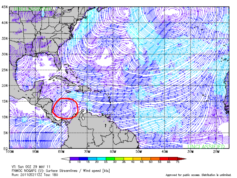
The Nogaps has a pretty good spin on the Caribbean around next Saturday. Granted is the Nogaps and last year it was hell bent on developing a storm on that exact same spot the whole season lol
0 likes
The following post is NOT an official forecast and should not be used as such. It is just the opinion of the poster and may or may not be backed by sound meteorological data. It is NOT endorsed by any professional institution including storm2k.org For Official Information please refer to the NHC and NWS products.
-
srainhoutx

- S2K Supporter
- Posts: 6919
- Age: 68
- Joined: Sun Jan 14, 2007 11:34 am
- Location: Haywood County, NC
- Contact:
Re: Global Model Runs Thread
Not sure we can see any development in the Western Basin as long as all that dry air is in place. Another 3 weeks or so and things will look a bit better IMO.

0 likes
Carla/Alicia/Jerry(In The Eye)/Michelle/Charley/Ivan/Dennis/Katrina/Rita/Wilma/Ike/Harvey
Member: National Weather Association
Wx Infinity Forums
http://wxinfinity.com/index.php
Facebook.com/WeatherInfinity
Twitter @WeatherInfinity
Member: National Weather Association
Wx Infinity Forums
http://wxinfinity.com/index.php
Facebook.com/WeatherInfinity
Twitter @WeatherInfinity
-
cycloneye

- Admin

- Posts: 149508
- Age: 69
- Joined: Thu Oct 10, 2002 10:54 am
- Location: San Juan, Puerto Rico
Re: Global Model Runs Thread
The question about the models is,which one will be the best in 2011? Last year IMO,it was ECMWF the stellar model,followed by GFS and CMC.
I would like to see a good consensus among the models,before I believe,something may develop. GFS has shown the Western Caribbean scenario for some days now on long range.
I would like to see a good consensus among the models,before I believe,something may develop. GFS has shown the Western Caribbean scenario for some days now on long range.
0 likes
Visit the Caribbean-Central America Weather Thread where you can find at first post web cams,radars
and observations from Caribbean basin members Click Here
and observations from Caribbean basin members Click Here

-
Tampa Bay Hurricane

- Category 5

- Posts: 5597
- Age: 38
- Joined: Fri Jul 22, 2005 7:54 pm
- Location: St. Petersburg, FL
-
Dean4Storms
- S2K Supporter
- Posts: 6358
- Age: 63
- Joined: Sun Aug 31, 2003 1:01 pm
- Location: Miramar Bch. FL
-
vbhoutex

- Storm2k Executive
- Posts: 29149
- Age: 74
- Joined: Wed Oct 09, 2002 11:31 pm
- Location: Cypress, TX
- Contact:
Re:
Dean4Storms wrote:Getting to be that time of year to really start paying attention out there. Don't know why, but I'm having a hard time getting into it this year. I think it is fear and knowing this could be a bad year!
You sound like me D4S. I just don't like what appears to be setting up for this season. Hopefully it will surprise us like last season did.
0 likes
Skywarn, C.E.R.T.
Please click below to donate to STORM2K to help with the expenses of keeping the site going:

Please click below to donate to STORM2K to help with the expenses of keeping the site going:
-
Dean4Storms
- S2K Supporter
- Posts: 6358
- Age: 63
- Joined: Sun Aug 31, 2003 1:01 pm
- Location: Miramar Bch. FL
-
cycloneye
- Admin
- Posts: 149508
- Age: 69
- Joined: Thu Oct 10, 2002 10:54 am
- Location: San Juan, Puerto Rico
Re: Global Model Runs Thread
Yeah,I know. It goes over me as a Tropical Storm  But is like many years ahead
  And is only one model.
0 likes
Visit the Caribbean-Central America Weather Thread where you can find at first post web cams,radars
and observations from Caribbean basin members Click Here
and observations from Caribbean basin members Click Here
-
Dean4Storms
- S2K Supporter
- Posts: 6358
- Age: 63
- Joined: Sun Aug 31, 2003 1:01 pm
- Location: Miramar Bch. FL
Re: Re:
vbhoutex wrote:Dean4Storms wrote:Getting to be that time of year to really start paying attention out there. Don't know why, but I'm having a hard time getting into it this year. I think it is fear and knowing this could be a bad year!
You sound like me D4S. I just don't like what appears to be setting up for this season. Hopefully it will surprise us like last season did.
We just don't need anything more up here on the North Gulf Coast, between the economy, Ivan and Katrina then the Oil Spill the economies around here are on shaky ground at best. A major hurricane would pretty much put a nail in it.
0 likes
-
Tampa Bay Hurricane
- Category 5
- Posts: 5597
- Age: 38
- Joined: Fri Jul 22, 2005 7:54 pm
- Location: St. Petersburg, FL
What does everyone think about that late season cool front last week over florida and the gulf? do you think it may push back the start a few weeks? Perhaps if dry fronts continue to move in this may keep shear too high and delay the start by a few weeks- but on the other hand this may be normal for late May and have no impact on hurricane season.
0 likes
-
cycloneye
- Admin
- Posts: 149508
- Age: 69
- Joined: Thu Oct 10, 2002 10:54 am
- Location: San Juan, Puerto Rico
Re: Global Model Runs Thread
ECMWF has been upgraded.Let's see how it performs during the 2011 Atlantic hurricane season.
Full release:
http://www.ecmwf.int/publications/cms/get/ecmwfnews/276
A new version of the ECMWF forecasting and analysis system, Cycle 37r2, was implemented on 18 May 2011. The new cycle includes both meteorological and technical changes. The main meteorological changes included in this cycle are the use of flow-dependent background errors in the data assimilation, reduced AMSU-A observation errors and improvements to cloud scheme. The changes show clear benefits in terms of objective upper-air scores in the medium range. Temperature and winds are improved throughout the troposphere in the extra-tropics. The improvements to the cloud scheme increase the humidity in the upper troposphere, providing a better fit to observations and improving humidity scores in the extra-tropics in the early forecast range.
0 likes
Visit the Caribbean-Central America Weather Thread where you can find at first post web cams,radars
and observations from Caribbean basin members Click Here
and observations from Caribbean basin members Click Here

Re: Global Model Runs Thread
The EURO rocks when you have a fully develope system and track out 168hr or so......but I dont think it grasps actual developement very well.....that is where the CMC, followed by the GFS comes in for me....
0 likes
-
Ivanhater

- Storm2k Moderator

- Posts: 11221
- Age: 39
- Joined: Fri Jul 01, 2005 8:25 am
- Location: Pensacola
Re: Global Model Runs Thread
GFS is insistent on developing a tropical storm in the Caribbean and lifting north.


0 likes
Michael

Though any hints of any long range GFS or ECMWF development are enough to peak my curiosity, I am even more intrigued by any mid level and upper level conditions that might hint where tropical cyclones might tend to originate, and more importantly where their general tracks might take them. It would certainly be interesting if anyone has taken the time ( or would care too ) to compare last year at this time to "current day" features ( i.e. TUTT condtions, overall 200mb flow impacting shear, strength & positioning of N. Atlantic/ "Bermuda High", strength of westerlies, etc. ).
Am noticing the first of many long ( and I mean very long ) range GFS runs hinting of early season development in the S.W. Caribean. Without taking a great deal of time to really start to analyze steering and upper level conditions for this early season system ( or model "ghost system" ), I did notice the lack of what I seemed to remember "last year", as a fairly persistant TUTT feature stretching from Puerto Rico and points northward.
Near term mid level models do certainly seem to indicate overall troughing into the deep south of the U.S. ( rather than a more typical E. Coast trough ) and fairly solid ridging in the northern Atlantic. The Atlantic season has yet to begin, and mid level and upper level conditions are constantly evolving, yet I seem to see nuances of conditions which would appear to bear out why various agencies ( both public or private ) are calling for potentially greater risk to the U.S. this season, as compared to the past couple of years. Would love to hear thoughts from anyone with "year to year" condition analysis.
0 likes
Andy D
(For official information, please refer to the NHC and NWS products.)
(For official information, please refer to the NHC and NWS products.)


-
floridasun78
- Category 5
- Posts: 3755
- Joined: Sun May 17, 2009 10:16 pm
- Location: miami fl


Re: Global Model Runs Thread
brings it over Cuba and ejects it east.....of course this is la la land....
http://www.nco.ncep.noaa.gov/pmb/nwprod ... n_372l.gif
http://www.nco.ncep.noaa.gov/pmb/nwprod ... n_372l.gif
0 likes
Who is online
Users browsing this forum: No registered users and 64 guests