Severe Weather - Week of May 22 Sunday thru Thursday

U.S. & Caribbean Weather Discussions and Severe Weather Events

Moderator: S2k Moderators

Forum rules

The posts in this forum are NOT official forecast and should not be used as such. They are just the opinion of the poster and may or may not be backed by sound meteorological data. They are NOT endorsed by any professional institution or STORM2K.

Help Support Storm2K
Message
Author
CrazyC83
Professional-Met
Professional-Met
Posts: 34002
Joined: Tue Mar 07, 2006 11:57 pm
Location: Deep South, for the first time!

Re: Re:

#221 Postby CrazyC83 » Sun May 22, 2011 10:44 pm

Ntxw wrote:
psyclone wrote:unfortunately, unlike many severe events that yield calm the following day, southwest missouri looks to have a respectable severe threat tomorrow as well.


God forbid it to become a situation like Tuscaloosa. Many were without power due to storms and tornadoes not long before the big one and many did not have access to warnings.


At least with no overnight severe, they will have an opportunity to get some things back up (outside of Joplin).
0 likes   

User avatar
Dave
Retired Staff
Retired Staff
Posts: 13442
Age: 74
Joined: Tue Aug 01, 2006 3:57 pm
Location: Milan Indiana
Contact:

#222 Postby Dave » Sun May 22, 2011 10:50 pm

BULLETIN - EAS ACTIVATION REQUESTED
TORNADO WARNING
NATIONAL WEATHER SERVICE TULSA OK
1046 PM CDT SUN MAY 22 2011

THE NATIONAL WEATHER SERVICE IN TULSA HAS ISSUED A

* TORNADO WARNING FOR...
CENTRAL BENTON COUNTY IN NORTHWEST ARKANSAS

* UNTIL 1130 PM CDT

* AT 1043 PM CDT...A SEVERE THUNDERSTORM CAPABLE OF PRODUCING A
TORNADO WAS LOCATED NEAR GENTRY...MOVING EAST AT 35 MPH.

* SOME LOCATIONS IN OR NEAR THE PATH OF THIS STORM INCLUDE...
GRAVETTE...HIGHFILL...HIWASSE...CAVE SPRINGS...BELLA VISTA AND
BENTONVILLE.

PRECAUTIONARY/PREPAREDNESS ACTIONS...

IF YOU ARE NEAR THE PATH OF THIS STORM...TAKE COVER NOW!
0 likes   

CrazyC83
Professional-Met
Professional-Met
Posts: 34002
Joined: Tue Mar 07, 2006 11:57 pm
Location: Deep South, for the first time!

Re: Re:

#223 Postby CrazyC83 » Sun May 22, 2011 10:50 pm

vbhoutex wrote:
wx247 wrote:
CrazyC83 wrote:So what will Joplin get rated I wonder?

I say it depends on the quality of construction, that would be the difference between EF4 and EF5.

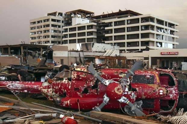
The hospital damage was probably EF3, the houses around it EF4. But there may have been EF5 damage elsewhere.


If you can find a before and after picture of the St John's Hospital you will be surprised by how devastated it actually is.

There is nothing except rubble as far as the eye can see. I saw not one wall even standing. Part of the equation is the quality of construction, but from what I saw that hospital was pretty well trashed and to say the least it is a substantial structure. An EF5 designation would not surprise me, but imo EF4 is a definite.


Agreed EF4 for sure. The only question mark is quality of construction of the houses surrounding it. I don't know enough about them to make the decision between EF4 and EF5. The hospital's condition (upper floors gone but not total destruction, EFKit has that between high EF2 and low EF4) would make me want to only go to EF4 though (winds about 180 mph there), thinking their construction is not at perfect shape. However, that is just one part of the track.

A permanent house with a slab swept clean (FR12 DOD10) ranges from 165 to 220 mph, with 200 mph expected.

Either way, any violent tornado is EXTREMELY dangerous and you need to be in a hardened safe room or underground to have a good chance at surviving!
0 likes   

Brent
S2K Supporter
S2K Supporter
Posts: 38089
Age: 36
Joined: Sun May 16, 2004 10:30 pm
Location: Tulsa Oklahoma
Contact:

Re: Severe Weather - Week of May 22 Sunday thru Thursday

#224 Postby Brent » Sun May 22, 2011 10:59 pm

Image
0 likes   
#neversummer

User avatar
Dave
Retired Staff
Retired Staff
Posts: 13442
Age: 74
Joined: Tue Aug 01, 2006 3:57 pm
Location: Milan Indiana
Contact:

#225 Postby Dave » Sun May 22, 2011 11:00 pm

BENTON AR-
1057 PM CDT SUN MAY 22 2011

...TORNADO WARNING REMAINS IN EFFECT UNTIL 1130 PM CDT FOR CENTRAL
BENTON COUNTY...


AT 1055 PM CDT...DOPPLER RADAR CONTINUED TO INDICATE A SEVERE
THUNDERSTORM CAPABLE OF PRODUCING A TORNADO LOCATED NEAR VAUGHN...
MOVING EAST AT 35 MPH.

SOME LOCATIONS IN OR NEAR THE PATH OF THIS STORM INCLUDE...HIWASSE...
HEALING SPRINGS...CENTERTON...CAVE SPRINGS...MILLER...BELLA VISTA AND
BENTONVILLE.

PRECAUTIONARY/PREPAREDNESS ACTIONS...

IF YOU ARE NEAR THE PATH OF THIS STORM...TAKE COVER NOW!
0 likes   

User avatar
Dave
Retired Staff
Retired Staff
Posts: 13442
Age: 74
Joined: Tue Aug 01, 2006 3:57 pm
Location: Milan Indiana
Contact:

#226 Postby Dave » Sun May 22, 2011 11:03 pm

BULLETIN - EAS ACTIVATION REQUESTED
TORNADO WARNING
NATIONAL WEATHER SERVICE TULSA OK
1101 PM CDT SUN MAY 22 2011

THE NATIONAL WEATHER SERVICE IN TULSA HAS ISSUED A

* TORNADO WARNING FOR...
EASTERN DELAWARE COUNTY IN NORTHEAST OKLAHOMA
NORTHWESTERN BENTON COUNTY IN NORTHWEST ARKANSAS

* UNTIL 1130 PM CDT

* AT 1059 PM CDT...A SEVERE THUNDERSTORM CAPABLE OF PRODUCING A
TORNADO WAS LOCATED 5 MILES NORTHWEST OF MAYSVILLE...MOVING EAST AT
30 MPH.


* SOME LOCATIONS IN OR NEAR THE PATH OF THIS STORM INCLUDE...
MAYSVILLE.

PRECAUTIONARY/PREPAREDNESS ACTIONS...

IF YOU ARE NEAR THE PATH OF THIS STORM...TAKE COVER NOW!
0 likes   

CrazyC83
Professional-Met
Professional-Met
Posts: 34002
Joined: Tue Mar 07, 2006 11:57 pm
Location: Deep South, for the first time!

#227 Postby CrazyC83 » Sun May 22, 2011 11:13 pm

So I am thinking Tuesday will be the next super-active day, and tomorrow may be more isolated (but no less dangerous, especially in Oklahoma).
0 likes   

User avatar
Dave
Retired Staff
Retired Staff
Posts: 13442
Age: 74
Joined: Tue Aug 01, 2006 3:57 pm
Location: Milan Indiana
Contact:

#228 Postby Dave » Sun May 22, 2011 11:14 pm

BULLETIN - EAS ACTIVATION REQUESTED
TORNADO WARNING
NATIONAL WEATHER SERVICE TULSA OK
1112 PM CDT SUN MAY 22 2011

THE NATIONAL WEATHER SERVICE IN TULSA HAS ISSUED A

* TORNADO WARNING FOR...
CENTRAL BENTON COUNTY IN NORTHWEST ARKANSAS
NORTHEASTERN WASHINGTON COUNTY IN NORTHWEST ARKANSAS

* UNTIL 1145 PM CDT

* AT 1108 PM CDT...A SEVERE THUNDERSTORM CAPABLE OF PRODUCING A
TORNADO WAS LOCATED 2 MILES SOUTH OF CAVE SPRINGS...MOVING EAST AT
30 MPH.


* SOME LOCATIONS IN OR NEAR THE PATH OF THIS STORM INCLUDE...
LOWELL...SPRINGDALE AND WAR EAGLE.

PRECAUTIONARY/PREPAREDNESS ACTIONS...

IF YOU ARE NEAR THE PATH OF THIS STORM...TAKE COVER NOW!
0 likes   

User avatar
Dave
Retired Staff
Retired Staff
Posts: 13442
Age: 74
Joined: Tue Aug 01, 2006 3:57 pm
Location: Milan Indiana
Contact:

#229 Postby Dave » Sun May 22, 2011 11:16 pm

Going to call it a night...stay safe no matter where you are. Got a feeling today will be active again, going to get some sleep.
0 likes   

User avatar
OverlandHurricane
S2K Supporter
S2K Supporter
Posts: 58
Joined: Thu Aug 28, 2008 4:50 pm
Location: Minnesota

Re: Severe Weather - Week of May 22 Sunday thru Thursday

#230 Postby OverlandHurricane » Sun May 22, 2011 11:19 pm

Don't mean to take away from the coverage of the carnage down in Joplin, but the north side of Minneapolis got slammed today too.

http://www.startribune.com/local/122417279.html <= News story from the Strib
http://www.startribune.com/blogs/122425914.html <= Paul Douglas' blog with a recap of what happened in MSP
http://www.startribune.com/galleries/122418214.html <= Reader submitted photos.

Minneapolis PD and Hennepin County Sheriff are enforcing a curfew between I-94 and Penn to the east/west, and Plymouth and Dowling Avenues on the north/south sides. Apparently, there has been some looting going on.
0 likes   

CrazyC83
Professional-Met
Professional-Met
Posts: 34002
Joined: Tue Mar 07, 2006 11:57 pm
Location: Deep South, for the first time!

Re: Severe Weather - Week of May 22 Sunday thru Thursday

#231 Postby CrazyC83 » Sun May 22, 2011 11:22 pm

OverlandHurricane wrote:Don't mean to take away from the coverage of the carnage down in Joplin, but the north side of Minneapolis got slammed today too.

http://www.startribune.com/local/122417279.html <= News story from the Strib
http://www.startribune.com/blogs/122425914.html <= Paul Douglas' blog with a recap of what happened in MSP
http://www.startribune.com/galleries/122418214.html <= Reader submitted photos.

Minneapolis PD and Hennepin County Sheriff are enforcing a curfew between I-94 and Penn to the east/west, and Plymouth and Dowling Avenues on the north/south sides. Apparently, there has been some looting going on.


My guess for the Minneapolis tornado is high EF2/low EF3.
0 likes   

CrazyC83
Professional-Met
Professional-Met
Posts: 34002
Joined: Tue Mar 07, 2006 11:57 pm
Location: Deep South, for the first time!

#232 Postby CrazyC83 » Sun May 22, 2011 11:32 pm

One thing for sure - if tomorrow and especially Tuesday perform like the models suggest, this will be the THIRD mega-outbreak in the last 6 weeks...
0 likes   

User avatar
Cyclenall
Category 5
Category 5
Posts: 6666
Joined: Thu Jun 08, 2006 10:01 pm
Location: Ontario, Canada

Re: Severe Weather - Week of May 22 Sunday thru Thursday

#233 Postby Cyclenall » Sun May 22, 2011 11:41 pm

Another extraordinary tornado event, crazy. A horrific tornado season so far for sure.

There doesn't seem to be any actual tornado footage yet that I could find except some Live News coverage from a tower cam but it's very blurry and hard to discern. There should be more considering it hit a city so tomorrow we might see some additional footage. There are two factors that might explain lack of footage; rain-wrapped tornado so not as many filmed or knew of it and I believe this tornado was short-lived (10 mins?).

The hospital looks ravaged and it's total annihilation around it. I'm getting EF5 vibes :double: .
0 likes   

Brent
S2K Supporter
S2K Supporter
Posts: 38089
Age: 36
Joined: Sun May 16, 2004 10:30 pm
Location: Tulsa Oklahoma
Contact:

Re: Severe Weather - Week of May 22 Sunday thru Thursday

#234 Postby Brent » Mon May 23, 2011 12:56 am

[youtube]http://www.youtube.com/watch?v=cQnvxJZucds[/youtube]
0 likes   
#neversummer

Shoshana
Category 5
Category 5
Posts: 1414
Joined: Thu Sep 09, 2004 7:50 pm
Location: NE Austin

Re: Severe Weather - Week of May 22 Sunday thru Thursday

#235 Postby Shoshana » Mon May 23, 2011 2:09 am

^ wow
0 likes   

RL3AO
Moderator-Pro Met
Moderator-Pro Met
Posts: 16308
Joined: Thu Jun 14, 2007 10:03 pm
Location: NC

Re: Severe Weather - Week of May 22 Sunday thru Thursday

#236 Postby RL3AO » Mon May 23, 2011 2:21 am

The number of tornadoes hitting cities this year is scary.
0 likes   

User avatar
Bunkertor
Category 5
Category 5
Posts: 3397
Joined: Tue May 09, 2006 3:48 pm

#237 Postby Bunkertor » Mon May 23, 2011 3:27 am

Image
0 likes   

User avatar
wx247
S2K Supporter
S2K Supporter
Posts: 14279
Age: 41
Joined: Wed Feb 05, 2003 10:35 pm
Location: Monett, Missouri
Contact:

Re: Severe Weather - Week of May 22 Sunday thru Thursday

#238 Postby wx247 » Mon May 23, 2011 5:47 am

Two images of concern this morning:

Image

Storms are erupting across SE KS and Northern Oklahoma already. These have major hail potential.

Additionally:

Image

It is going to be a long day!
0 likes   
Personal Forecast Disclaimer:
The posts in this forum are NOT official forecast and should not be used as such. They are just the opinion of the poster and may or may not be backed by sound meteorological data. They are NOT endorsed by any professional institution or storm2k.org. For official information, please refer to the NHC and NWS products.

WeatherGuesser
Category 5
Category 5
Posts: 2672
Joined: Tue Jun 29, 2010 6:46 am

#239 Postby WeatherGuesser » Mon May 23, 2011 5:54 am

Local news raises the toll to 89, but I'm not sure if that's Joplin only or from all areas.
0 likes   

charlesw
S2K Supporter
S2K Supporter
Posts: 45
Joined: Thu Oct 28, 2010 6:39 am

Re: Severe Weather - Week of May 22 Sunday thru Thursday

#240 Postby charlesw » Mon May 23, 2011 5:59 am

That is from Joplin alone
0 likes   


Return to “USA & Caribbean Weather”

Who is online

Users browsing this forum: No registered users and 7 guests