Global model runs discussion
Moderator: S2k Moderators
-
Dean4Storms
- S2K Supporter

- Posts: 6358
- Age: 63
- Joined: Sun Aug 31, 2003 1:01 pm
- Location: Miramar Bch. FL
-
cycloneye

- Admin

- Posts: 149508
- Age: 69
- Joined: Thu Oct 10, 2002 10:54 am
- Location: San Juan, Puerto Rico
Re: Global Model Runs Thread
0 likes
Visit the Caribbean-Central America Weather Thread where you can find at first post web cams,radars
and observations from Caribbean basin members Click Here
and observations from Caribbean basin members Click Here
-
SFLcane

- S2K Supporter
- Posts: 10281
- Age: 48
- Joined: Sat Jun 05, 2010 1:44 pm
- Location: Lake Worth Florida
Re: Global Model Runs Thread
Might have to wait until the 3rd week of June for next MJO to come around.
0 likes
-
TreasureIslandFLGal

- S2K Supporter
- Posts: 1584
- Age: 58
- Joined: Sun Aug 15, 2004 6:16 pm
- Location: Cancun, Mexico (northeast Yucatan coast)
Re: Global Model Runs Thread
Need a few weeks for the shear to relax too before anything can even start to get going.
0 likes
Chrissy & Ligeia

-
flwxwatcher
- Category 4

- Posts: 926
- Joined: Wed May 16, 2007 3:35 pm
- Location: Central Florida
Re: Global Model Runs Thread
If todays 12Z EURO is right ,we might just have to wait until this time next week. It looks like it brings a system across Florida and developes it in the Gulf.
http://www.ecmwf.int/products/forecasts ... 1052412!!/
http://www.ecmwf.int/products/forecasts ... 1052412!!/
0 likes


Re: Global Model Runs Thread
flwx, the low pressure in the GOM from 12Z Euro appears to be derived from a cutoff mid-level low over FL. It's showing a reflection at both the surface and 500 mb. It would have to transition from cold to warm core.
http://raleighwx.americanwx.com/models/euro/12zeurotropical500mbSLP216.gif
http://raleighwx.americanwx.com/models/euro/12zeurotropical500mbSLP216.gif
0 likes
-
SETXWXLADY
- Tropical Storm

- Posts: 216
- Joined: Wed May 20, 2009 3:26 pm
- Location: SE TX Orange County
Looks like the 12z CMC is showing something too.
http://moe.met.fsu.edu/cgi-bin/cmctc2.c ... =Animation
http://moe.met.fsu.edu/cgi-bin/cmctc2.c ... =Animation
0 likes
-
vbhoutex

- Storm2k Executive
- Posts: 29149
- Age: 74
- Joined: Wed Oct 09, 2002 11:31 pm
- Location: Cypress, TX
- Contact:
Re: Global Model Runs Thread
After attending the Hurricane Seminar given by Impact Weather today here in Houston, ECMWF is my model of choice for this season. It has outperformed all the other models for the last 3 years. Obviously other models are performing well to, but the statistics show that ECMWF has outperformed them all.
0 likes
Skywarn, C.E.R.T.
Please click below to donate to STORM2K to help with the expenses of keeping the site going:

Please click below to donate to STORM2K to help with the expenses of keeping the site going:
-
weatherSnoop

- S2K Supporter
- Posts: 702
- Age: 63
- Joined: Wed Oct 09, 2002 10:06 pm
- Location: Tampa, FL
- Contact:
Re: Global Model Runs Thread
vbhoutex wrote:After attending the Hurricane Seminar given by Impact Weather today here in Houston, ECMWF is my model of choice for this season. It has outperformed all the other models for the last 3 years. Obviously other models are performing well to, but the statistics show that ECMWF has outperformed them all.
Oh Boy! Yet another Euro Hugger... at least we are not alone
0 likes
-
Ivanhater

- Storm2k Moderator

- Posts: 11221
- Age: 39
- Joined: Fri Jul 01, 2005 8:25 am
- Location: Pensacola
Re: Global Model Runs Thread
18z GFS still develops this...Pulls out of the Caribbean toward the Carolinas.


0 likes
Michael
-
Huracan Gorges
- Tropical Wave

- Posts: 7
- Age: 35
- Joined: Sat May 14, 2011 2:45 pm
- Location: BAYAMON, Puerto Rico
Re: Global Model Runs Thread
Looks like the action soon .........is going to be in the SW Caribbean Sea.........Kepping possible the Main Caribbean Ilands.......A Clouse Eye on the future of this future LOW Pressure........Developing in the SW Courtnner of Caribbean Sea 
0 likes
-
Rgv20

- S2K Supporter
- Posts: 2466
- Age: 39
- Joined: Wed Jan 05, 2011 5:42 pm
- Location: Edinburg/McAllen Tx
Re: Global Model Runs Thread
weatherSnoop wrote:vbhoutex wrote:After attending the Hurricane Seminar given by Impact Weather today here in Houston, ECMWF is my model of choice for this season. It has outperformed all the other models for the last 3 years. Obviously other models are performing well to, but the statistics show that ECMWF has outperformed them all.
Oh Boy! Yet another Euro Hugger... at least we are not alone
You can add me to the list....All Hail King Euro!!
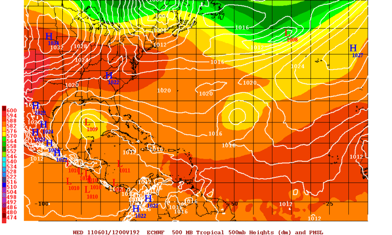
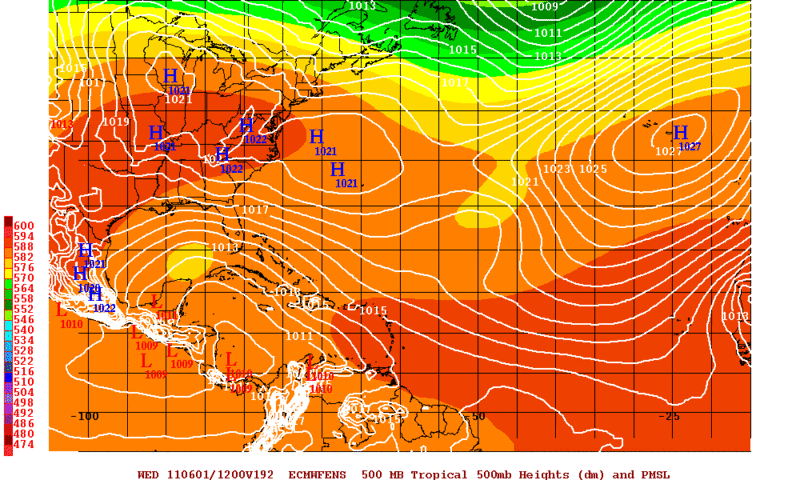
Interesting looking at the 500mb heights that the Euro ensembles mostly agree on that cutoff mid-level low.
0 likes
The following post is NOT an official forecast and should not be used as such. It is just the opinion of the poster and may or may not be backed by sound meteorological data. It is NOT endorsed by any professional institution including storm2k.org For Official Information please refer to the NHC and NWS products.

Re: Global Model Runs Thread
vbhoutex wrote:After attending the Hurricane Seminar given by Impact Weather today here in Houston, ECMWF is my model of choice for this season. It has outperformed all the other models for the last 3 years. Obviously other models are performing well to, but the statistics show that ECMWF has outperformed them all.
I couldnt go this year because of work but I bet it was interesting. I have been a few times. I know Derek was there.
The EURO does rock and its very hard to go against it....welcome to the EURO camp. You can sit right next to me, Ivan and Wx warrior....
0 likes
-
vbhoutex
- Storm2k Executive
- Posts: 29149
- Age: 74
- Joined: Wed Oct 09, 2002 11:31 pm
- Location: Cypress, TX
- Contact:
Re: Global Model Runs Thread
ROCK wrote:vbhoutex wrote:After attending the Hurricane Seminar given by Impact Weather today here in Houston, ECMWF is my model of choice for this season. It has outperformed all the other models for the last 3 years. Obviously other models are performing well to, but the statistics show that ECMWF has outperformed them all.
I couldnt go this year because of work but I bet it was interesting. I have been a few times. I know Derek was there.
The EURO does rock and its very hard to go against it....welcome to the EURO camp. You can sit right next to me, Ivan and Wx warrior....
Sounds good to me. I'll take that seat.
The seminar was very interesting. Also got to meet and talk with Derek, Chris Hebert, Chris Landsea, Phillip Klotzbach and Katdaddy.
0 likes
Skywarn, C.E.R.T.
Please click below to donate to STORM2K to help with the expenses of keeping the site going:
Please click below to donate to STORM2K to help with the expenses of keeping the site going:
-
cycloneye
- Admin
- Posts: 149508
- Age: 69
- Joined: Thu Oct 10, 2002 10:54 am
- Location: San Juan, Puerto Rico
Re: Global Model Runs Thread
cycloneye wrote:ECMWF has been upgraded.Let's see how it performs during the 2011 Atlantic hurricane season.
Full release:
http://www.ecmwf.int/publications/cms/get/ecmwfnews/276
A new version of the ECMWF forecasting and analysis system, Cycle 37r2, was implemented on 18 May 2011. The new cycle includes both meteorological and technical changes. The main meteorological changes included in this cycle are the use of flow-dependent background errors in the data assimilation, reduced AMSU-A observation errors and improvements to cloud scheme. The changes show clear benefits in terms of objective upper-air scores in the medium range. Temperature and winds are improved throughout the troposphere in the extra-tropics. The improvements to the cloud scheme increase the humidity in the upper troposphere, providing a better fit to observations and improving humidity scores in the extra-tropics in the early forecast range.
For those who missed this post about the ECMWF upgrade,here it is.
0 likes
Visit the Caribbean-Central America Weather Thread where you can find at first post web cams,radars
and observations from Caribbean basin members Click Here
and observations from Caribbean basin members Click Here
-
Dean4Storms
- S2K Supporter
- Posts: 6358
- Age: 63
- Joined: Sun Aug 31, 2003 1:01 pm
- Location: Miramar Bch. FL
NWS Tallahassee AFD about next week with this upper level feature near FL.
THE FORECAST DETAILS BECOME A BIT MORE TRICKY BY THE END OF THE
WEEKEND...AND ESPECIALLY DURING THE EARLY PORTION OF NEXT WEEK. A
PIECE OF THE ENERGY ASSOCIATED WITH THE DEPARTING TROUGH IS FORECAST
TO BE LEFT BEHIND AND CLOSE OFF TO OUR SOUTHEAST TOWARD SOUTH FL OR
THE BAHAMAS DURING THE WEEKEND. HOWEVER...GLOBAL GUIDANCE IS NOT IN
COMPLETE AGREEMENT AS TO THE EVOLUTION OF THIS ENERGY. LATEST GFS IS
FAVORING A STRONGER UPPER RIDGE AXIS OVER THE SE STATES AND AS A
RESULT FORCING MUCH OF THIS ENERGY TO STAY EAST OF THE FL PENINSULA
(AT LEAST THROUGH MONDAY). ECMWF ON THE OTHER HAND IS MORE AGGRESSIVE
IN ALLOWING THIS ENERGY TO CUT-OFF AND DRIFT BACK WESTWARD INTO THE
GULF OF MEXICO. IF THIS WERE TO VERIFY...IT COULD ENHANCE THE
POTENTIAL FOR SEA-BREEZE GENERATED CONVECTION. THIS SOLUTION WOULD
ALSO RESULT IN MORE DIURNAL CLOUD-COVER FOR OUR REGION...AND
SLIGHTLY COOLER DAYTIME TEMPERATURES. FOR NOW...WILL NOT BITE OFF ON
THE ECMWF SOLUTION AND WILL LEAN THE FORECAST CLOSER TO THE 00Z
CANADIAN WHICH ISN`T AS STRONG WITH THE RIDGE OVERHEAD AS THE
GFS...BUT ALSO NOT AS AGGRESSIVE WITH THE UPPER LOW.
0 likes
-
SETXWXLADY
- Tropical Storm
- Posts: 216
- Joined: Wed May 20, 2009 3:26 pm
- Location: SE TX Orange County
Re:
Dean4Storms wrote:NWS Tallahassee AFD about next week with this upper level feature near FL.
THE FORECAST DETAILS BECOME A BIT MORE TRICKY BY THE END OF THE
WEEKEND...AND ESPECIALLY DURING THE EARLY PORTION OF NEXT WEEK. A
PIECE OF THE ENERGY ASSOCIATED WITH THE DEPARTING TROUGH IS FORECAST
TO BE LEFT BEHIND AND CLOSE OFF TO OUR SOUTHEAST TOWARD SOUTH FL OR
THE BAHAMAS DURING THE WEEKEND. HOWEVER...GLOBAL GUIDANCE IS NOT IN
COMPLETE AGREEMENT AS TO THE EVOLUTION OF THIS ENERGY. LATEST GFS IS
FAVORING A STRONGER UPPER RIDGE AXIS OVER THE SE STATES AND AS A
RESULT FORCING MUCH OF THIS ENERGY TO STAY EAST OF THE FL PENINSULA
(AT LEAST THROUGH MONDAY). ECMWF ON THE OTHER HAND IS MORE AGGRESSIVE
IN ALLOWING THIS ENERGY TO CUT-OFF AND DRIFT BACK WESTWARD INTO THE
GULF OF MEXICO. IF THIS WERE TO VERIFY...IT COULD ENHANCE THE
POTENTIAL FOR SEA-BREEZE GENERATED CONVECTION. THIS SOLUTION WOULD
ALSO RESULT IN MORE DIURNAL CLOUD-COVER FOR OUR REGION...AND
SLIGHTLY COOLER DAYTIME TEMPERATURES. FOR NOW...WILL NOT BITE OFF ON
THE ECMWF SOLUTION AND WILL LEAN THE FORECAST CLOSER TO THE 00Z
CANADIAN WHICH ISN`T AS STRONG WITH THE RIDGE OVERHEAD AS THE
GFS...BUT ALSO NOT AS AGGRESSIVE WITH THE UPPER LOW.
I think this is what the EURO has been showing for at least four runs now to varying degrees of development. The CMC has been showing this off and on as well. I guess we'll see if anything comes of it.


0 likes
-
Dean4Storms
- S2K Supporter
- Posts: 6358
- Age: 63
- Joined: Sun Aug 31, 2003 1:01 pm
- Location: Miramar Bch. FL
-
SETXWXLADY
- Tropical Storm
- Posts: 216
- Joined: Wed May 20, 2009 3:26 pm
- Location: SE TX Orange County
Re: Global Model Runs Thread
Oh well. Had to be up late anway. 
The EURO and CMC still at it. Well the CMC seems to be showing a couple of lows.

The EURO and CMC still at it. Well the CMC seems to be showing a couple of lows.
0 likes
Who is online
Users browsing this forum: No registered users and 47 guests