
Global model runs discussion
Moderator: S2k Moderators
-
SETXWXLADY
- Tropical Storm

- Posts: 216
- Joined: Wed May 20, 2009 3:26 pm
- Location: SE TX Orange County
Re: Global Model Runs Discussion
At the end of the EURO run it shows another low tracking east to west across the gulf in addition to the one in the Caribbean. Interesting that that may be another slow mover/developer like last year. Anyway, just one run so far on the gulf one. As always we shall see. 
0 likes
-
cycloneye

- Admin

- Posts: 149508
- Age: 69
- Joined: Thu Oct 10, 2002 10:54 am
- Location: San Juan, Puerto Rico
Re: Global Model Runs Discussion
The 12z model package starts with GFS continuing to show the Western Caribbean development. It would be a slow proccess to develop according to this model.
96 hours
120 hours
192 hours
96 hours
120 hours
192 hours
0 likes
Visit the Caribbean-Central America Weather Thread where you can find at first post web cams,radars
and observations from Caribbean basin members Click Here
and observations from Caribbean basin members Click Here


-
srainhoutx

- S2K Supporter

- Posts: 6919
- Age: 68
- Joined: Sun Jan 14, 2007 11:34 am
- Location: Haywood County, NC
- Contact:
Re: Global Model Runs Discussion
It appears to be a monsoonal trough setup to me, at the 850mb level. There are 'hints' of a TUTT traversing the Gulf later next week though on the 12Z GFS.
0 likes
Carla/Alicia/Jerry(In The Eye)/Michelle/Charley/Ivan/Dennis/Katrina/Rita/Wilma/Ike/Harvey
Member: National Weather Association
Wx Infinity Forums
http://wxinfinity.com/index.php
Facebook.com/WeatherInfinity
Twitter @WeatherInfinity
Member: National Weather Association
Wx Infinity Forums
http://wxinfinity.com/index.php
Facebook.com/WeatherInfinity
Twitter @WeatherInfinity
-
cycloneye
- Admin
- Posts: 149508
- Age: 69
- Joined: Thu Oct 10, 2002 10:54 am
- Location: San Juan, Puerto Rico
Re: Global Model Runs Discussion
0 likes
Visit the Caribbean-Central America Weather Thread where you can find at first post web cams,radars
and observations from Caribbean basin members Click Here
and observations from Caribbean basin members Click Here
-
MiamiHurricanes10

- S2K Supporter
- Posts: 260
- Joined: Mon Jul 19, 2010 7:56 pm
- Location: Miami, Florida
Re: Global Model Runs Discussion
SETXWXLADY wrote:At the end of the EURO run it shows another low tracking east to west across the gulf in addition to the one in the Caribbean. Interesting that that may be another slow mover/developer like last year. Anyway, just one run so far on the gulf one. As always we shall see.
That's just an upper-low in the Gulf of Mexico advecting towards the west making a reflection at the 850mb level. The real trouble will be in the Caribbean as the subtropical jet lifts north, and the aforementioned upper-low helps to ventilate the area [Caribbean].
0 likes
-
cycloneye
- Admin
- Posts: 149508
- Age: 69
- Joined: Thu Oct 10, 2002 10:54 am
- Location: San Juan, Puerto Rico
Re: Global Model Runs Discussion
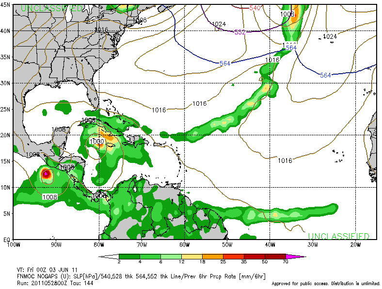
12z NOGAPS

0 likes
Visit the Caribbean-Central America Weather Thread where you can find at first post web cams,radars
and observations from Caribbean basin members Click Here
and observations from Caribbean basin members Click Here
-
MiamiHurricanes10
- S2K Supporter
- Posts: 260
- Joined: Mon Jul 19, 2010 7:56 pm
- Location: Miami, Florida
Re: Global Model Runs Discussion
At 168 hours the ECMWF shows something similar to the GFS with the first feature remaining weak and broad moving towards the north and a secondary feature developing to the northeast of the first one.

0 likes
-
JonathanBelles
- Professional-Met

- Posts: 11430
- Age: 35
- Joined: Sat Dec 24, 2005 9:00 pm
- Location: School: Florida State University (Tallahassee, FL) Home: St. Petersburg, Florida
- Contact:

-
Dean4Storms
- S2K Supporter
- Posts: 6358
- Age: 63
- Joined: Sun Aug 31, 2003 1:01 pm
- Location: Miramar Bch. FL
-
JonathanBelles
- Professional-Met
- Posts: 11430
- Age: 35
- Joined: Sat Dec 24, 2005 9:00 pm
- Location: School: Florida State University (Tallahassee, FL) Home: St. Petersburg, Florida
- Contact:
Re: Global Model Runs Discussion
Dean4Storms wrote:Fact789.............Check that date...April
Thats an NHC mistake. April 28th was on a Thursday. That is a current graphic.
0 likes


-
JonathanBelles
- Professional-Met
- Posts: 11430
- Age: 35
- Joined: Sat Dec 24, 2005 9:00 pm
- Location: School: Florida State University (Tallahassee, FL) Home: St. Petersburg, Florida
- Contact:
Re: Global Model Runs Discussion
boca wrote:Hey Fact do you have the link to the map you posted.
It is an experimental product from the NHC that is posted here every day at 8pm ET/00z
0 likes

-
Rgv20

- S2K Supporter
- Posts: 2466
- Age: 39
- Joined: Wed Jan 05, 2011 5:42 pm
- Location: Edinburg/McAllen Tx
Nogaps still being happy with the Caribbean disturbance.
0 likes
The following post is NOT an official forecast and should not be used as such. It is just the opinion of the poster and may or may not be backed by sound meteorological data. It is NOT endorsed by any professional institution including storm2k.org For Official Information please refer to the NHC and NWS products.

Re: Global Model Runs Discussion
Still a few more days before we see something come together.IMO.really bare out there right now with some high shear.....models are all over this so hard to to go against them.....
0 likes
-
cycloneye
- Admin
- Posts: 149508
- Age: 69
- Joined: Thu Oct 10, 2002 10:54 am
- Location: San Juan, Puerto Rico
Re: Global Model Runs Discussion
The 00z package was bullish,except GFS that was the less agressive.See all of them here.
http://moe.met.fsu.edu/tcgengifs/
http://moe.met.fsu.edu/tcgengifs/
0 likes
Visit the Caribbean-Central America Weather Thread where you can find at first post web cams,radars
and observations from Caribbean basin members Click Here
and observations from Caribbean basin members Click Here
-
cycloneye
- Admin
- Posts: 149508
- Age: 69
- Joined: Thu Oct 10, 2002 10:54 am
- Location: San Juan, Puerto Rico
Re: Global Model Runs Discussion
Different from the SW Caribbean scenario,GFS on the very long range shows another development.But is lala-land.

Uploaded by imageshack.us
Uploaded by imageshack.us
0 likes
Visit the Caribbean-Central America Weather Thread where you can find at first post web cams,radars
and observations from Caribbean basin members Click Here
and observations from Caribbean basin members Click Here
Re: Global Model Runs Discussion
http://wxmaps.org/pix/hurpot.html#ATL
wont be long now....potential is out there except along the gulf coast. By next week all of the GOM will have cat3-5 potential.
wont be long now....potential is out there except along the gulf coast. By next week all of the GOM will have cat3-5 potential.
0 likes
Re: Global Model Runs Discussion
however with shear like this you can forget about anything stacking....very hostile out there attm...
http://tropic.ssec.wisc.edu/real-time/w ... oom=&time=
http://tropic.ssec.wisc.edu/real-time/w ... oom=&time=
0 likes
Who is online
Users browsing this forum: No registered users and 41 guests