Area of disturbed weather in SW Caribbean (Is invest 94L)
Moderator: S2k Moderators
Forum rules
The posts in this forum are NOT official forecasts and should not be used as such. They are just the opinion of the poster and may or may not be backed by sound meteorological data. They are NOT endorsed by any professional institution or STORM2K. For official information, please refer to products from the National Hurricane Center and National Weather Service.
- Ivanhater
- Storm2k Moderator

- Posts: 11221
- Age: 39
- Joined: Fri Jul 01, 2005 8:25 am
- Location: Pensacola
Re: Area of disturbed weather in the SW Caribbean
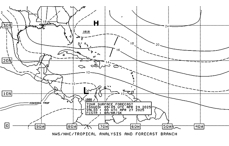
A stationary 1007mb low sitting in the Western Caribbean in 72 hours according to the NHC.


0 likes
Michael
Re: Area of disturbed weather in the SW Caribbean
Oh I agree..the start of the season is always slow until shear relaxes....NOGAPS finished up the 12zrun....buries it in CA but a piece of energy splits off and heads into SFL....seems plausible..all in all a big mess right now...
https://www.fnmoc.navy.mil/wxmap_cgi/cg ... t=Tropical
https://www.fnmoc.navy.mil/wxmap_cgi/cg ... t=Tropical
0 likes
- Ivanhater
- Storm2k Moderator

- Posts: 11221
- Age: 39
- Joined: Fri Jul 01, 2005 8:25 am
- Location: Pensacola
Re: Area of disturbed weather in the SW Caribbean
Getting really interesting....concentrated complex right over the 1008mb developing low.
14mph Northerly wind report off the Nicaraguan coast..and has been since 9a.m

http://weather.noaa.gov/weather/current/MNBL.html
14mph Northerly wind report off the Nicaraguan coast..and has been since 9a.m

http://weather.noaa.gov/weather/current/MNBL.html
0 likes
Michael
Nice little area of convection down there, its in the area that needs watching over the next few days.
0 likes
Personal Forecast Disclaimer:
The posts in this forum are NOT official forecast and should not be used as such. They are just the opinion of the poster and may or may not be backed by sound meteorological data. They are NOT endorsed by any professional institution or storm2k.org. For official information, please refer to the NHC and NWS products
The posts in this forum are NOT official forecast and should not be used as such. They are just the opinion of the poster and may or may not be backed by sound meteorological data. They are NOT endorsed by any professional institution or storm2k.org. For official information, please refer to the NHC and NWS products
- HURAKAN
- Professional-Met

- Posts: 46084
- Age: 39
- Joined: Thu May 20, 2004 4:34 pm
- Location: Key West, FL
- Contact:
Re: Area of disturbed weather in the SW Caribbean
MARINE WEATHER DISCUSSION
NWS NATIONAL HURRICANE CENTER MIAMI FL
245 PM EDT MON MAY 30 2011
CARIBBEAN SEA AND TROPICAL N ATLC W OF 55W...
A SURFACE TROUGH WAS ANALYZED FROM THE COAST OF NICARAGUA NEAR
12N84W TO THE PANAMA CANAL ON THE 1200 UTC SURFACE MAP. THE 1442
ASCAT PASS SHOWED THE WIND SHIFT ASSOCIATED WITH THE TROUGH. IN
ADDITION...SOME SHIP OBSERVATIONS INDICATED NE TO E WINDS OF 15
TO 20 KT NORTH OF THE TROUGH OVER THE SW CARIBBEAN. WINDS ARE
FORECAST TO INCREASE TO 20 TO 25 KT TONIGHT OVER THE S-CENTRAL
CARIBBEAN AS PRES GRADIENT TIGHTENS BETWEEN HIGH PRES TO THE N
AND DEVELOPING LOW PRES OVER THE SW CARIBBEAN. AS A RESULT OF
THE STRONGER WINDS...SEAS WILL BUILD OVER THE CENTRAL CARIBBEAN
TO 8 TO 10 FT BY TUE.
COMPUTER MODELS CONTINUE TO INDICATE THE POTENTIAL FOR THE
GRADUAL DEVELOPMENT OF BROAD LOW PRESSURE OVER THE SW CARIBBEAN
DURING THE NEXT SEVERAL DAYS. THE DEVELOPING LOW SHOULD
INITIALLY BE OVER THE SW CARIBBEAN NEAR SAN ANDRES AND IS THEN
FORECAST TO DEEPEN SLIGHTLY AS IT DRIFTS NWD INTO WEST CENTRAL
CARIBBEAN ROUGHLY ALONG 80W TOWARD THE END OF THE PERIOD. MARINE
INTERESTS OVER THE REGION SHOULD MONITOR THIS SYSTEM CLOSELY
SINCE ITS POTENTIAL FORMATION COINCIDES WITH THE BEGINNING OF
THE ATLANTIC HURRICANE SEASON AND OVER A REGION THAT IS
CLIMATOLOGICALLY FAVORED FOR TROPICAL CYCLONE FORMATION DURING
THE MONTH OF JUNE.
A WEAK TROPICAL WAVE ALONG 65W S OF 13N WILL CONTINUE TO MIGRATE
W THROUGH THE SE CARIBBEAN AND CENTRAL VENEZUELA THIS AFTERNOON
AND TONIGHT REACHING NEAR 68W TUE MORNING...AND NEAR 72W WED
MORNING. THIS WAVE IS PRODUCING SOME SHOWER ACTIVITY AND GUSTY
WINDS.
0 likes
- HURAKAN
- Professional-Met

- Posts: 46084
- Age: 39
- Joined: Thu May 20, 2004 4:34 pm
- Location: Key West, FL
- Contact:
Link: http://weather.noaa.gov/weather/current/SKSP.html
Pressures in San Andres remain pretty steady, 1007-1009 mb
Pressures in San Andres remain pretty steady, 1007-1009 mb
0 likes
- stormhunter7
- Category 2

- Posts: 763
- Joined: Mon May 26, 2008 3:13 pm
- Location: Panama City Beach, Florida
- Contact:
Re: Area of disturbed weather in the SW Caribbean
0 likes
The following post is NOT an official forecast and should not be used as such. It is just the opinion of the poster and may or may not be backed by sound meteorological data. It is NOT endorsed by any professional institution including storm2k.org For Official Information please refer to the NHC and NWS products. http://www.nhc.noaa.gov
-
Weatherfreak000
Re: Area of disturbed weather in the SW Caribbean
This is remarkably similar to the start of Arlene. Funny since this season we finally use those names again. Time will tell but with model support this season I can see this becoming something.
0 likes
- Rgv20
- S2K Supporter

- Posts: 2466
- Age: 39
- Joined: Wed Jan 05, 2011 5:42 pm
- Location: Edinburg/McAllen Tx
Re:
HURAKAN wrote:Link: http://weather.noaa.gov/weather/current/SKSP.html
Pressures in San Andres remain pretty steady, 1007-1009 mb
Down to 1006mb as of 21z 05/30/11
0 likes
The following post is NOT an official forecast and should not be used as such. It is just the opinion of the poster and may or may not be backed by sound meteorological data. It is NOT endorsed by any professional institution including storm2k.org For Official Information please refer to the NHC and NWS products.
Re: Global Model Runs Discussion
http://www.nco.ncep.noaa.gov/pmb/nwprod ... n_132l.gif
out 132hrs 18z GFS......just sitting down there....
out 132hrs 18z GFS......just sitting down there....
0 likes
Re: Global Model Runs Discussion
http://moe.met.fsu.edu/cgi-bin/cmctc2.c ... =Animation
12z CMC not liking it as it was before.....NOGAP 18z out 120hr is a bit agressive...
https://www.fnmoc.navy.mil/wxmap_cgi/cg ... t=Tropical
remaining loop of the NOGAPS.....looks jacked up to me with 2 lows heading towards SFL then splitting...or sheared out....
12z CMC not liking it as it was before.....NOGAP 18z out 120hr is a bit agressive...
https://www.fnmoc.navy.mil/wxmap_cgi/cg ... t=Tropical
remaining loop of the NOGAPS.....looks jacked up to me with 2 lows heading towards SFL then splitting...or sheared out....
0 likes
Re: Area of disturbed weather in the SW Caribbean
Ivan are we posting model runs here on this feature or in the other thread? just checking
BTW- nice to see you back for another season.... sorry I have had a few shiners...
BTW- nice to see you back for another season....
0 likes
- Ivanhater
- Storm2k Moderator

- Posts: 11221
- Age: 39
- Joined: Fri Jul 01, 2005 8:25 am
- Location: Pensacola
Re: Area of disturbed weather in the SW Caribbean
ROCK wrote:Ivan are we posting model runs here on this feature or in the other thread? just checking
BTW- nice to see you back for another season....sorry I have had a few shiners...
Good to see you back Rock! Where is our other partner in crime, Wxwarrior?
Yeah, this is the thread for the Caribbean system. Taking a look at the Canadian and Euro ensembles, a great deal of them like the solution of getting trapped under the ridge.
[img]

Uploaded with ImageShack.us[/img]
0 likes
Michael
Who is online
Users browsing this forum: No registered users and 470 guests


