Area of disturbed weather in SW Caribbean (Is invest 94L)

This is the general tropical discussion area. Anyone can take their shot at predicting a storms path.

Moderator: S2k Moderators

Forum rules

The posts in this forum are NOT official forecasts and should not be used as such. They are just the opinion of the poster and may or may not be backed by sound meteorological data. They are NOT endorsed by any professional institution or STORM2K. For official information, please refer to products from the National Hurricane Center and National Weather Service.

Help Support Storm2K
Message
Author
User avatar
ROCK
Category 5
Category 5
Posts: 9484
Age: 54
Joined: Tue Aug 17, 2004 7:30 am
Location: Kemah, Texas

Re: Area of disturbed weather in the SW Caribbean

#101 Postby ROCK » Mon May 30, 2011 6:30 pm

Ha... :lol: Wx Warrior is still in hibernation I suppose.....He will be here soon enough I am sure...

the ensembles make sense to me given the time of year and the death heat ridge that has been sitting over the South for about 8 weeks....Wasnt Dean or maybe Felix that was a early storm that ran right into a huge ridge over the GOM? I will have to look it up....

Also the ensemles give hints to what the next model run might look like......


good to be back!!!
0 likes   

User avatar
stormhunter7
Category 2
Category 2
Posts: 762
Joined: Mon May 26, 2008 3:13 pm
Location: Panama City Beach, Florida
Contact:

Re: Area of disturbed weather in the SW Caribbean

#102 Postby stormhunter7 » Mon May 30, 2011 6:37 pm

yall just send some moisture this way... NW Florida is pretty darn dry! :) http://flame.fl-dof.com/fire_weather/KBDI/index.html
0 likes   
The following post is NOT an official forecast and should not be used as such. It is just the opinion of the poster and may or may not be backed by sound meteorological data. It is NOT endorsed by any professional institution including storm2k.org For Official Information please refer to the NHC and NWS products. http://www.nhc.noaa.gov

User avatar
dixiebreeze
S2K Supporter
S2K Supporter
Posts: 5140
Joined: Wed Sep 03, 2003 5:07 pm
Location: crystal river, fla.

Re: Area of disturbed weather in the SW Caribbean

#103 Postby dixiebreeze » Mon May 30, 2011 6:58 pm

http://www.ssd.noaa.gov/goes/east/watl/flash-rb.html

convection may be deepening a bit, reds showing up in this IR.
0 likes   

User avatar
northjaxpro
S2K Supporter
S2K Supporter
Posts: 8900
Joined: Mon Sep 27, 2010 11:21 am
Location: Jacksonville, FL

#104 Postby northjaxpro » Mon May 30, 2011 7:05 pm

This stubborn Ridge over the Southern/SE US appears to be locked in place looking at all of these long range model runs. This pattern seems to look very similar to what we had most of last hurricane season, with the ridge deflecting tropical cyclones away from the CONUS.

We will watch the developments in the Caribbean in the coming days, but I am wondering how much northward progression this potential system will actually make? The ridge looks rather stout to me in the long range for this system to do anything but move west/ west-northwest after about 5-7 days.
0 likes   
NEVER, EVER SAY NEVER in the tropics and weather in general, and most importantly, with life itself!!

________________________________________________________________________________________

Fay 2008 Beryl 2012 Debby 2012 Colin 2016 Hermine 2016 Julia 2016 Matthew 2016 Irma 2017 Dorian 2019

User avatar
stormhunter7
Category 2
Category 2
Posts: 762
Joined: Mon May 26, 2008 3:13 pm
Location: Panama City Beach, Florida
Contact:

Re: Area of disturbed weather in the SW Caribbean

#105 Postby stormhunter7 » Mon May 30, 2011 7:18 pm

If that ridge breaks down.... much need tropical moisture could head north.... but doesn't appear like it will anytime soon! :(
Image
0 likes   
The following post is NOT an official forecast and should not be used as such. It is just the opinion of the poster and may or may not be backed by sound meteorological data. It is NOT endorsed by any professional institution including storm2k.org For Official Information please refer to the NHC and NWS products. http://www.nhc.noaa.gov

jinftl
Category 5
Category 5
Posts: 4312
Joined: Tue Aug 31, 2004 4:47 pm
Location: fort lauderdale, fl

Re: Area of disturbed weather in the SW Caribbean

#106 Postby jinftl » Mon May 30, 2011 7:22 pm

Excerpt from NWS Miami Discussion this evening:

AREA FORECAST DISCUSSION
NATIONAL WEATHER SERVICE MIAMI FL
744 PM EDT MON MAY 30 2011

DISCUSSION...

THE OPERATIONAL MODELS CONTINUE TO ADVERTISE VARYING SOLUTIONS
FRIDAY THROUGH EARLY NEXT WEEK, ALTHOUGH IT APPEARS MOST
PLAUSIBLE THAT AT LEAST A BROAD AREA OF LOW PRESSURE WILL
CONTINUE TO ORGANIZE IN THE WESTERN CARIBBEAN WITH SOME INCREASE
IN MOISTURE ACROSS THE LOCAL AREA. THE EXACT EVOLUTION OF A LARGE
TROUGH OVER THE WESTERN STATES WILL ULTIMATELY PLAY A SIGNIFICANT
ROLE IN THE PATH OF THE CARIBBEAN LOW.
0 likes   

User avatar
Ivanhater
Storm2k Moderator
Storm2k Moderator
Posts: 11160
Age: 38
Joined: Fri Jul 01, 2005 8:25 am
Location: Pensacola

Re: Area of disturbed weather in the SW Caribbean

#107 Postby Ivanhater » Mon May 30, 2011 8:09 pm

Something is cooking

Image
0 likes   
Michael

psyclone
S2K Supporter
S2K Supporter
Posts: 4762
Joined: Wed Aug 24, 2005 9:04 pm
Location: palm harbor fl

#108 Postby psyclone » Mon May 30, 2011 8:12 pm

the persistence today is noteworthy. i'm kinda surprised this hasn't been tagged an invest yet.
0 likes   

User avatar
srainhoutx
S2K Supporter
S2K Supporter
Posts: 6919
Age: 67
Joined: Sun Jan 14, 2007 11:34 am
Location: Haywood County, NC
Contact:

Re: Area of disturbed weather in the SW Caribbean

#109 Postby srainhoutx » Mon May 30, 2011 8:16 pm

TWD:

CARIBBEAN SEA...
A TROPICAL WAVE IS OVER THE E CARIBBEAN AND ANOTHER IS
APPROACHING. SEE ABOVE. A SURFACE TROUGH IS OVER THE SW
CARIBBEAN AND NICARAGUA ALONG 13N85W 10N80W.
SCATTERED MODERATE
TO ISOLATED STRONG CONVECTION IS NE OF THE TROUGH AXIS FROM
11N-16N BETWEEN 78W-84W. ANOTHER SURFACE TROUGH IS OVER
HISPANIOLA. RADAR IMAGERY FROM PUERTO RICO SHOWS LARGE AREAS OF
SCATTERED SHOWERS N AND S OF THE ISLAND. SATELLITE IMAGERY SHOWS
SIMILAR CLOUD AND SHOWER COVERAGE FROM E CUBA TO THE NE
CARIBBEAN N OF 17N. THE NW CARIBBEAN HAS FAIR WEATHER. 15-20 KT
TRADEWINDS COVER THE ENTIRE CARIBBEAN WITH STRONGEST WINDS OVER
THE CENTRAL CARIBBEAN. IN THE UPPER LEVELS...AN UPPER LEVEL
TROUGH IS OVER THE NW CARIBBEAN WITH STRONG SUBSIDENCE. AN UPPER
LEVEL RIDGE IS OVER THE CENTRAL AND E CARIBBEAN E OF 75W WITH
CONSIDERABLE UPPER LEVEL MOISTURE. EXPECT...THE TROPICAL WAVES
TO MOVE W OVER THE NEXT 24 HOURS.

0 likes   
Carla/Alicia/Jerry(In The Eye)/Michelle/Charley/Ivan/Dennis/Katrina/Rita/Wilma/Ike/Harvey

Member: National Weather Association
Wx Infinity Forums
http://wxinfinity.com/index.php

Facebook.com/WeatherInfinity
Twitter @WeatherInfinity

User avatar
HeeBGBz
Category 1
Category 1
Posts: 341
Age: 70
Joined: Sun Sep 03, 2006 3:25 pm
Location: Biloxi, MS

Re: Area of disturbed weather in the SW Caribbean

#110 Postby HeeBGBz » Mon May 30, 2011 8:17 pm

Hi everyone. It's about that time again. It seems we have something to watch from the getgo. :clap:
0 likes   

User avatar
SouthFLTropics
Category 5
Category 5
Posts: 4236
Age: 50
Joined: Thu Aug 14, 2003 8:04 am
Location: Port St. Lucie, Florida

Re: Area of disturbed weather in the SW Caribbean

#111 Postby SouthFLTropics » Mon May 30, 2011 8:43 pm

In the immortal words of Michael Buffer..."Uhhhh Let's Get Ready to Rummmmmbbbbbllllllleeeee!!!!"

Good to be back for another season of tracking on S2K!!!

I'd like to see this thing develop into a nice TD or TS and head up our way here in South Florida. My yard is very parched!!!

SFT
0 likes   
Fourth Generation Florida Native

Personal Storm History: David 79, Andrew 92, Erin 95, Floyd 99, Irene 99, Frances 04, Jeanne 04, Wilma 05, Matthew 16, Irma 17, Ian 22, Nicole 22, Milton 24

jinftl
Category 5
Category 5
Posts: 4312
Joined: Tue Aug 31, 2004 4:47 pm
Location: fort lauderdale, fl

Re: Area of disturbed weather in the SW Caribbean

#112 Postby jinftl » Mon May 30, 2011 9:29 pm

A good drenching would be great for sure...climatology is not on our side if we are looking for drought-busting from a tropical system in June, though. Since 1895, only 5 tropical storms (and no hurricanes) have impacted South Florida in June...the last one being in 1968.

Doesn't mean we won't tap into some of that moisture in time, and the rainy season can really begin!!!

SouthFLTropics wrote:In the immortal words of Michael Buffer..."Uhhhh Let's Get Ready to Rummmmmbbbbbllllllleeeee!!!!"

Good to be back for another season of tracking on S2K!!!

I'd like to see this thing develop into a nice TD or TS and head up our way here in South Florida. My yard is very parched!!!

SFT
0 likes   

User avatar
ROCK
Category 5
Category 5
Posts: 9484
Age: 54
Joined: Tue Aug 17, 2004 7:30 am
Location: Kemah, Texas

Re: Area of disturbed weather in the SW Caribbean

#113 Postby ROCK » Mon May 30, 2011 9:33 pm

it has been persistent I give it that with 30-40kt shear over head....that shear zone needs to lift out some if its going to do anything at the surface, IMO


http://tropic.ssec.wisc.edu/real-time/w ... oom=&time=
0 likes   

jinftl
Category 5
Category 5
Posts: 4312
Joined: Tue Aug 31, 2004 4:47 pm
Location: fort lauderdale, fl

Re: Area of disturbed weather in the SW Caribbean

#114 Postby jinftl » Mon May 30, 2011 9:49 pm

Shear is blasting this area of the caribbean right now...certainly looks to be an area of disturbed weather, but i don't see how it could become an organized area of disturbed weather with these conditions if they persist.

Image
0 likes   

User avatar
cycloneye
Admin
Admin
Posts: 145277
Age: 68
Joined: Thu Oct 10, 2002 10:54 am
Location: San Juan, Puerto Rico

Re: Area of disturbed weather in the SW Caribbean

#115 Postby cycloneye » Mon May 30, 2011 10:02 pm

The 00z surface analysis shows the Colombian low at 1005 mbs,while a new low is north of Panama.

Image

Uploaded by imageshack.us
0 likes   
Visit the Caribbean-Central America Weather Thread where you can find at first post web cams,radars
and observations from Caribbean basin members Click Here

User avatar
Hylian Auree
Tropical Storm
Tropical Storm
Posts: 150
Age: 32
Joined: Thu Dec 02, 2010 7:01 pm
Location: Willemstad, Curaçao
Contact:

Re: Area of disturbed weather in the SW Caribbean

#116 Postby Hylian Auree » Mon May 30, 2011 11:16 pm

Shear seems to be gradually lifting northward in the area.
Image
0 likes   

User avatar
Rgv20
S2K Supporter
S2K Supporter
Posts: 2466
Age: 38
Joined: Wed Jan 05, 2011 5:42 pm
Location: Edinburg/McAllen Tx

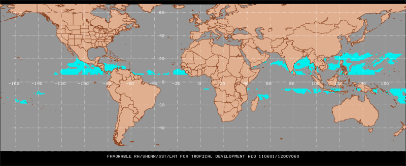
#117 Postby Rgv20 » Mon May 30, 2011 11:22 pm

According to this map...Wednesday is when conditions appear favorable for the SW Caribbean.

Image
0 likes   
The following post is NOT an official forecast and should not be used as such. It is just the opinion of the poster and may or may not be backed by sound meteorological data. It is NOT endorsed by any professional institution including storm2k.org For Official Information please refer to the NHC and NWS products.

User avatar
ROCK
Category 5
Category 5
Posts: 9484
Age: 54
Joined: Tue Aug 17, 2004 7:30 am
Location: Kemah, Texas

Re: Area of disturbed weather in the SW Caribbean

#118 Postby ROCK » Mon May 30, 2011 11:37 pm

Image


looks like a sheared mess at 174 on the 0z GFS......
0 likes   

Migle
Tropical Storm
Tropical Storm
Posts: 203
Age: 43
Joined: Fri Aug 27, 2010 5:30 pm
Location: New Orleans

Re: Area of disturbed weather in the SW Caribbean

#119 Postby Migle » Tue May 31, 2011 2:56 am

Image

It's weird how the burst of convection have been moving around alot, but it's held itself up pretty well so far. I think we'll see an invest soon enough.
0 likes   

User avatar
GCANE
S2K Supporter
S2K Supporter
Posts: 11496
Joined: Mon Oct 22, 2007 8:03 am

Re: Area of disturbed weather in the SW Caribbean

#120 Postby GCANE » Tue May 31, 2011 5:54 am

High rain-rate hot-towers are firing north of Panama


Image
0 likes   


Return to “Talkin' Tropics”

Who is online

Users browsing this forum: Cpv17 and 26 guests