WPAC: SARIKA - Tropical Depression
Moderator: S2k Moderators
-
StormingB81

- S2K Supporter

- Posts: 5676
- Age: 44
- Joined: Thu Aug 27, 2009 1:45 am
- Location: Rockledge, Florida
WPAC: SARIKA - Tropical Depression
Just posted on the NRL website..doesn;t even have the corrdinates yet..looks like about 8N and 146E....I cant put photos up where I am at because I am not home...This is Just south of Guam
Last edited by StormingB81 on Thu Jun 09, 2011 8:45 am, edited 2 times in total.
0 likes
Re: WPAC: Invest 92W
Well south of Guam.
92WINVEST.15kts-1010mb-50N-1450E.

Old NWS Guam satellite discussion.
000
ATPQ40 PGUM 021501
SIMGUM
SATELLITE INTERPRETATION MESSAGE
NATIONAL WEATHER SERVICE TIYAN GU
100 AM CHST FRI JUN 3 2011
WESTERN NORTH PACIFIC BETWEEN EQUATOR AND 25N FROM 130E TO 180.
AN UPPER-LEVEL LOW CENTERED NORTHWEST OF YAP AT 12N135E IS
GENERATING ISOLATED THUNDERSTORMS JUST TO THE EAST OF YAP BETWEEN
11N AND 7N FROM 138E TO 141E.
A SURFACE TROUGH STRETCHES SOUTHEASTWARD FROM 10N142E TO END NEAR
1N146E. SCATTERED SHOWERS AND ISOLATED THUNDERSTORMS ARE FOUND SOUTH
OF THE MARIANAS WITHIN 150 MILES OF A LINE FROM 10N143E TO 1N144E.
CONVERGING EAST WINDS ARE PRODUCING SCATTERED SHOWERS AND A FEW
THUNDERSTORMS OVER CHUUK AND POHNPEI BETWEEN 9N AND EQ FROM 147E TO
158E AND JUST WEST OF KOSRAE WITHIN 110 MILES OF A LINE FROM 6N158E
TO 5N163E. FARTHER EAST...SCATTERED SHOWERS ARE LOCATED EAST OF
KOSRAE BETWEEN 7N AND 1N FROM 164E TO 173E AND SOUTHEAST OF MAJURO
WITHIN 100 MILES OF A LINE FROM 4N176E AND 4N180.
&&
Nothing on JTWC STWA.
92WINVEST.15kts-1010mb-50N-1450E.
Old NWS Guam satellite discussion.
000
ATPQ40 PGUM 021501
SIMGUM
SATELLITE INTERPRETATION MESSAGE
NATIONAL WEATHER SERVICE TIYAN GU
100 AM CHST FRI JUN 3 2011
WESTERN NORTH PACIFIC BETWEEN EQUATOR AND 25N FROM 130E TO 180.
AN UPPER-LEVEL LOW CENTERED NORTHWEST OF YAP AT 12N135E IS
GENERATING ISOLATED THUNDERSTORMS JUST TO THE EAST OF YAP BETWEEN
11N AND 7N FROM 138E TO 141E.
A SURFACE TROUGH STRETCHES SOUTHEASTWARD FROM 10N142E TO END NEAR
1N146E. SCATTERED SHOWERS AND ISOLATED THUNDERSTORMS ARE FOUND SOUTH
OF THE MARIANAS WITHIN 150 MILES OF A LINE FROM 10N143E TO 1N144E.
CONVERGING EAST WINDS ARE PRODUCING SCATTERED SHOWERS AND A FEW
THUNDERSTORMS OVER CHUUK AND POHNPEI BETWEEN 9N AND EQ FROM 147E TO
158E AND JUST WEST OF KOSRAE WITHIN 110 MILES OF A LINE FROM 6N158E
TO 5N163E. FARTHER EAST...SCATTERED SHOWERS ARE LOCATED EAST OF
KOSRAE BETWEEN 7N AND 1N FROM 164E TO 173E AND SOUTHEAST OF MAJURO
WITHIN 100 MILES OF A LINE FROM 4N176E AND 4N180.
&&
Nothing on JTWC STWA.
0 likes
-
dexterlabio
- Category 5

- Posts: 3506
- Joined: Sat Oct 24, 2009 11:50 pm
Re: WPAC: Invest 92W
Shear tendency
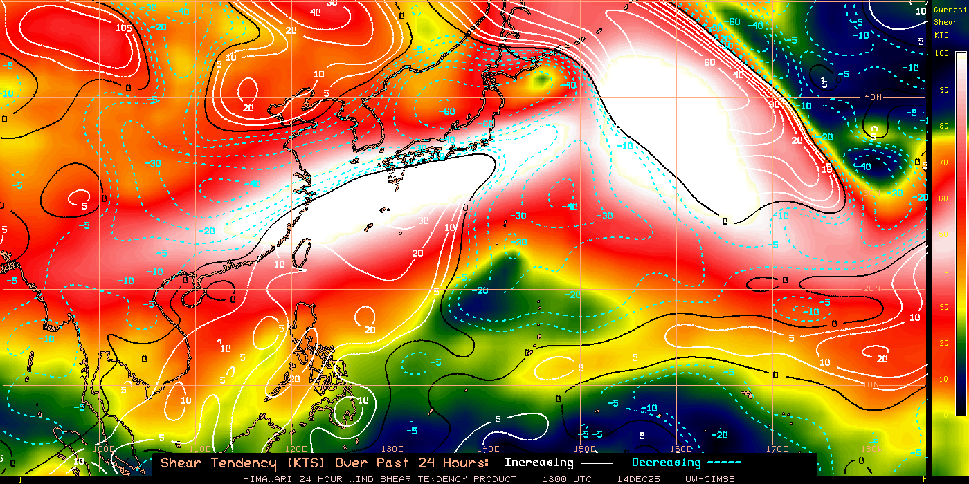

Not expecting much from it yet. We'll see in the coming days.
Not expecting much from it yet. We'll see in the coming days.
0 likes
Personal Forecast Disclaimer:
The posts in this forum are NOT official forecast and should not be used as such. They are just the opinion of the poster and may or may not be backed by sound meteorological data. They are NOT endorsed by any professional institution or storm2k.org. For official information, please refer to the NHC and NWS products.
The posts in this forum are NOT official forecast and should not be used as such. They are just the opinion of the poster and may or may not be backed by sound meteorological data. They are NOT endorsed by any professional institution or storm2k.org. For official information, please refer to the NHC and NWS products.
-
StormingB81
- S2K Supporter
- Posts: 5676
- Age: 44
- Joined: Thu Aug 27, 2009 1:45 am
- Location: Rockledge, Florida
JTWC upgrades to low:
(1) AN AREA OF CONVECTION HAS PERSISTED NEAR 5.5N 145.0E,
APPROXIMATELY 470 NM SOUTH OF ANDERSEN AIR FORCE BASE, GUAM.
ANIMATED MULTISPECTRAL SATELLITE IMAGERY SHOWS CONVECTION BEGINNING
TO ORGANIZE AROUND A NEWLY FORMING LOW LEVEL CIRCULATION CENTER
(LLCC). THE LLCC DEVELOPED AT THE SOUTHERN TIP OF A WAVE IN THE
EASTERLIES. A 022348Z PARTIAL ASCAT PASS TOGETHER WITH THE 030000Z
PGTW STREAMLINE ANALYSIS POINT TO A DISTINCT LLCC UNDERNEATH A BROAD
AND DIFFUSE AREA OF CONVECTION. A 030400Z TRMM MICROWAVE IMAGE
REVEALS THE CONVECTION IS DEEP BUT POORLY ORGANIZED. THE CIRCULATION
EXISTS IN AN AREA OF HIGHLY DIFFLUENT UPPER LEVEL WIND FLOW WITH
WEAK VERTICAL WIND SHEAR. SEA SURFACE TEMPERATURES ARE HIGHLY
FAVORABLE FOR DEVELOPMENT, 29-30 DEGREES CELSISUS. MAXIMUM
SUSTAINED SURFACEWINDS ARE ESTIMATED AT 10 TO 15 KNOTS. MINIMUM SEA
LEVEL PRESSURE IS ESTIMATED TO BE NEAR 1010 MB. THE POTENTIAL FOR
THE DEVELOPMENT OF A SIGNIFICANT TROPICAL CYCLONE WITHIN THE NEXT 24
HOURS IS LOW.
0 likes
-
dexterlabio
- Category 5
- Posts: 3506
- Joined: Sat Oct 24, 2009 11:50 pm
Re: WPAC: Invest 92W

Hmmm...familiar?
0 likes
Personal Forecast Disclaimer:
The posts in this forum are NOT official forecast and should not be used as such. They are just the opinion of the poster and may or may not be backed by sound meteorological data. They are NOT endorsed by any professional institution or storm2k.org. For official information, please refer to the NHC and NWS products.
The posts in this forum are NOT official forecast and should not be used as such. They are just the opinion of the poster and may or may not be backed by sound meteorological data. They are NOT endorsed by any professional institution or storm2k.org. For official information, please refer to the NHC and NWS products.
-
StormingB81
- S2K Supporter
- Posts: 5676
- Age: 44
- Joined: Thu Aug 27, 2009 1:45 am
- Location: Rockledge, Florida
-
rdhdstpchld
- Tropical Depression

- Posts: 79
- Joined: Mon May 09, 2011 3:47 am
Re:
StormingB81 wrote:Okinawa should just put a target on it the way this year si starting off...lol
During my cleanup I looked at my "completely-strapped-down" patio and thought "should I even bother un-strapping everything??"
In hindsight, I should have left it strapped; that would guarantee no more storms...now that it's unstrapped and actually useable again, I'm sure we'll be back in TCCOR 3 within a week...
0 likes
-
dexterlabio
- Category 5
- Posts: 3506
- Joined: Sat Oct 24, 2009 11:50 pm
Re: WPAC: Invest 92W
Should its path remains with very low shear along with the present favorable conditions, I'd say it has real high chance of becoming a TC, probably a typhoon. Just interesting to note that this may follow the track of the first two storms in the basin this year.
0 likes
Personal Forecast Disclaimer:
The posts in this forum are NOT official forecast and should not be used as such. They are just the opinion of the poster and may or may not be backed by sound meteorological data. They are NOT endorsed by any professional institution or storm2k.org. For official information, please refer to the NHC and NWS products.
The posts in this forum are NOT official forecast and should not be used as such. They are just the opinion of the poster and may or may not be backed by sound meteorological data. They are NOT endorsed by any professional institution or storm2k.org. For official information, please refer to the NHC and NWS products.

dexterlabio, yeah that path is interesting, of course it best not rush too quickly to the north otherwizse it'll hit a wall of shear that is forecasted to remain running off China for the next week or so.
0 likes
Personal Forecast Disclaimer:
The posts in this forum are NOT official forecast and should not be used as such. They are just the opinion of the poster and may or may not be backed by sound meteorological data. They are NOT endorsed by any professional institution or storm2k.org. For official information, please refer to the NHC and NWS products
The posts in this forum are NOT official forecast and should not be used as such. They are just the opinion of the poster and may or may not be backed by sound meteorological data. They are NOT endorsed by any professional institution or storm2k.org. For official information, please refer to the NHC and NWS products
-
Extratropical94

- Professional-Met

- Posts: 3545
- Age: 31
- Joined: Wed Oct 20, 2010 6:36 am
- Location: Hamburg, Germany
- Contact:
Re: WPAC: Invest 92W
Oh boy 
Aere, Songda, maybe Sarika, there seems to be a sort of magnet in Luzon.

CMC might not be the most accurate model intensity-wise, but the track does remind us of something.
Aere, Songda, maybe Sarika, there seems to be a sort of magnet in Luzon.

CMC might not be the most accurate model intensity-wise, but the track does remind us of something.
0 likes
54° 11' 59'' N, 9° 9' 20'' E
Boomer Sooner!
Go Broncos! Go Cards!
Clinching counties, one at a time: https://mob-rule.com/user-gifs/USA/xtrp94.gif
- Daniel
Boomer Sooner!
Go Broncos! Go Cards!
Clinching counties, one at a time: https://mob-rule.com/user-gifs/USA/xtrp94.gif
- Daniel
-
StormingB81
- S2K Supporter
- Posts: 5676
- Age: 44
- Joined: Thu Aug 27, 2009 1:45 am
- Location: Rockledge, Florida
Re: WPAC: Invest 92W
Extratropical94 wrote:Oh boy
Aere, Songda, maybe Sarika, there seems to be a sort of magnet in Luzon.
CMC might not be the most accurate model intensity-wise, but the track does remind us of something.
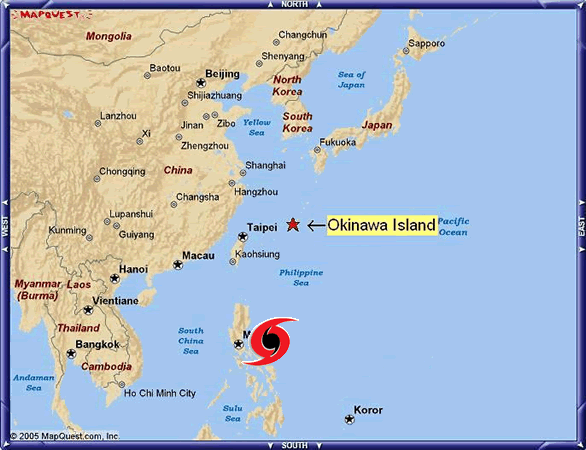
Well all those stroms hit Okinawa too...But I see a tremd goign on so far early in this season...they all love the same poath..but it isnt even a depression or anything yet and thats still a long ways out so we just have to wait and see what happends..
0 likes
-
StormingB81
- S2K Supporter
- Posts: 5676
- Age: 44
- Joined: Thu Aug 27, 2009 1:45 am
- Location: Rockledge, Florida

Remember..this is five days out....ANd like KWT stated thereis forecasted to be a lot of shear for a week or so..
Last edited by StormingB81 on Fri Jun 03, 2011 6:36 pm, edited 1 time in total.
0 likes
Re: WPAC: Invest 92W

000
ATPQ40 PGUM 031455
SIMGUM
SATELLITE INTERPRETATION MESSAGE
NATIONAL WEATHER SERVICE TIYAN GU
100 AM CHST SAT JUN 4 2011
WESTERN NORTH PACIFIC BETWEEN EQUATOR AND 25N FROM 130E TO 180.
A SURFACE TROUGH RUNS EASTWARD FROM 3N130E THROUGH A CIRCULATION
CENTERED SOUTHEAST OF YAP 5N143E...THEN TURNS SOUTHEASTWARD TO END
AT EQ150E. SCATTERED SHOWERS AND ISOLATED THUNDERSTORMS ARE LOCATED
SOUTHWEST OF CHUUK BETWEEN 10N AND 1N FROM 140E TO 152E.
CONVERGING EAST WINDS ARE PRODUCING SCATTERED SHOWERS AND A FEW
THUNDERSTORMS OVER KOSRAE AND THE MARSHALL ISLANDS BETWEEN 10N AND
3N FROM 161E TO 171E.
&&
0 likes


Re: WPAC: Invest 92W
I just got to go look at my husband's shop that was damaged by Songda, yesterday...All the doors were shattered, the roof caved in, one whole wall is gone. They had to move them into a different building. Seems like the common consensus is that Okinawa has been too lucky for too long and even the locals are thinking this is our year.
I wonder if the Taiwan typhoon magnet has split - half went to Luzon, the other to Okinawa.
I wonder if the Taiwan typhoon magnet has split - half went to Luzon, the other to Okinawa.
0 likes
-
Typhoon Hunter
- WesternPacificWeather.com

- Posts: 1222
- Joined: Wed Oct 11, 2006 11:37 am
- Location: Tokyo
- Contact:
Re: WPAC: Invest 92W
Infdidoll wrote:I just got to go look at my husband's shop that was damaged by Songda, yesterday...All the doors were shattered, the roof caved in, one whole wall is gone. They had to move them into a different building. Seems like the common consensus is that Okinawa has been too lucky for too long and even the locals are thinking this is our year.
I wonder if the Taiwan typhoon magnet has split - half went to Luzon, the other to Okinawa.
What kind of building was it, certainly doesn't sound like it was built according to typhoon resistant codes? Hope they get it fixed up soon! Songda may well be a blessing in disguise having given Okinawa a good blow and putting typhoons in the minds of the folks there because if a major makes a direct hit later in the season it'll make Songda look like a summer breeze - but hopefully people will be prepared!
0 likes
-
dexterlabio
- Category 5
- Posts: 3506
- Joined: Sat Oct 24, 2009 11:50 pm
Re: WPAC: Invest 92W
Infdidoll wrote:I just got to go look at my husband's shop that was damaged by Songda, yesterday...All the doors were shattered, the roof caved in, one whole wall is gone. They had to move them into a different building. Seems like the common consensus is that Okinawa has been too lucky for too long and even the locals are thinking this is our year.
I wonder if the Taiwan typhoon magnet has split - half went to Luzon, the other to Okinawa.
Your husband's shop seemed to have been sucked out by strong winds. At this point of the year, at least people will be more cautious.
I believe that every year, WPAC has something to surprise everyone. Before, I thought that TC activity especially in the PI follows an alternating pattern every season, like in 2004 when there were lots of pretty destructive storms and 2005 seemed to be a less active season, then came in 2006 when supertyphoons like Cimaron and Durian were formed. That idea was proven wrong coming 2007 because it remained a pretty active season, so with years 2008 and 2009. 2010 was kinda quiet except in the later part when STY Megi emerged. Well, it's really important not to let our guards down especially that we are in the Western Pacific.
....I'm waiting for ECMWF runs if they will show something about this. I'll get more serious about this when more models hint its development.
0 likes
Personal Forecast Disclaimer:
The posts in this forum are NOT official forecast and should not be used as such. They are just the opinion of the poster and may or may not be backed by sound meteorological data. They are NOT endorsed by any professional institution or storm2k.org. For official information, please refer to the NHC and NWS products.
The posts in this forum are NOT official forecast and should not be used as such. They are just the opinion of the poster and may or may not be backed by sound meteorological data. They are NOT endorsed by any professional institution or storm2k.org. For official information, please refer to the NHC and NWS products.
-
dexterlabio
- Category 5
- Posts: 3506
- Joined: Sat Oct 24, 2009 11:50 pm
Re:
KWT wrote:dexterlabio, yeah that path is interesting, of course it best not rush too quickly to the north otherwizse it'll hit a wall of shear that is forecasted to remain running off China for the next week or so.
Yeah the shear across that area remains strong and if it tracks northward quickly maybe that would prevent it to intensify. You can see the present shear condition above in my previous post.
0 likes
Personal Forecast Disclaimer:
The posts in this forum are NOT official forecast and should not be used as such. They are just the opinion of the poster and may or may not be backed by sound meteorological data. They are NOT endorsed by any professional institution or storm2k.org. For official information, please refer to the NHC and NWS products.
The posts in this forum are NOT official forecast and should not be used as such. They are just the opinion of the poster and may or may not be backed by sound meteorological data. They are NOT endorsed by any professional institution or storm2k.org. For official information, please refer to the NHC and NWS products.

-
dexterlabio
- Category 5
- Posts: 3506
- Joined: Sat Oct 24, 2009 11:50 pm
Re: WPAC: INVEST 92W
ABPW10 PGTW 040600
MSGID/GENADMIN/NAVMARFCSTCEN PEARL HARBOR HI/JTWC//
SUBJ/SIGNIFICANT TROPICAL WEATHER ADVISORY FOR THE WESTERN AND
/SOUTH PACIFIC OCEANS/040600Z-050600ZJUN2011//
RMKS/
1. WESTERN NORTH PACIFIC AREA (180 TO MALAY PENINSULA):
A. TROPICAL CYCLONE SUMMARY: NONE.
B. TROPICAL DISTURBANCE SUMMARY:
(1) THE AREA OF CONVECTION PREVIOUSLY LOCATED NEAR 5.5N
145.0E, HAS DISSIPATED AND IS NO LONGER SUSPECT FOR THE DEVELOPMENT
OF A SIGNIFICANT TROPICAL CYCLONE IN THE NEXT 24 HOURS.
(2) NO OTHER SUSPECT AREAS.
2. SOUTH PACIFIC AREA (WEST COAST OF SOUTH AMERICA TO 135 EAST):
A. TROPICAL CYCLONE SUMMARY: NONE.
B. TROPICAL DISTURBANCE SUMMARY: NONE.//
NNNN
Dissipated.
0 likes
Personal Forecast Disclaimer:
The posts in this forum are NOT official forecast and should not be used as such. They are just the opinion of the poster and may or may not be backed by sound meteorological data. They are NOT endorsed by any professional institution or storm2k.org. For official information, please refer to the NHC and NWS products.
The posts in this forum are NOT official forecast and should not be used as such. They are just the opinion of the poster and may or may not be backed by sound meteorological data. They are NOT endorsed by any professional institution or storm2k.org. For official information, please refer to the NHC and NWS products.
-
StormingB81
- S2K Supporter
- Posts: 5676
- Age: 44
- Joined: Thu Aug 27, 2009 1:45 am
- Location: Rockledge, Florida
Who is online
Users browsing this forum: No registered users and 7 guests