
Nogaps 18z run this is a very nice site.
https://www.fnmoc.navy.mil/wxmap_cgi/cg ... t=Tropical
ATL: INVEST 94L - DISCUSSION
Moderator: S2k Moderators
-
Rgv20

- S2K Supporter

- Posts: 2466
- Age: 39
- Joined: Wed Jan 05, 2011 5:42 pm
- Location: Edinburg/McAllen Tx
Re: ATL: INVEST 94L - MODELS
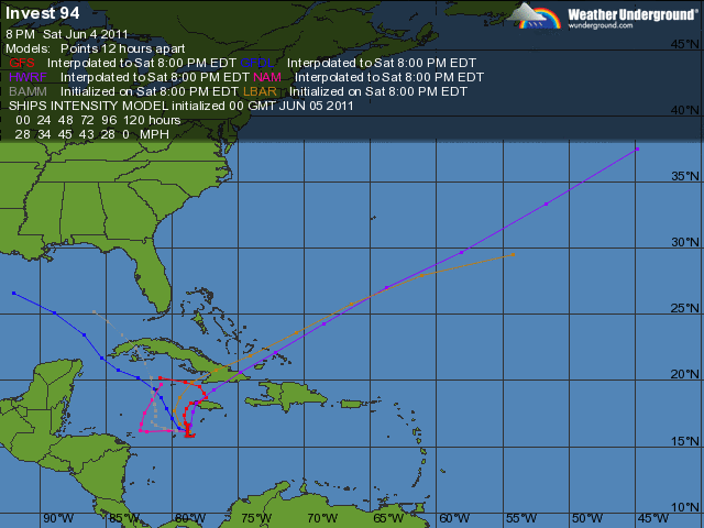
srainhoutx wrote:The GDFL run raises an eyebrow. On the other hand, the HWRF suggests a much quicker consolidation. I tend to believe the slower of the two make more sense with a monsoonal trough/gyre.The following post is NOT an official forecast and should not be used as such. It is just the opinion of the poster and may or may not be backed by sound meteorological data. It is NOT endorsed by any professional institution including storm2k.org For Official Information please refer to the NHC and NWS products.
Interesting to note that the GFDL is much faster in regards to movement than the global models.
0 likes
The following post is NOT an official forecast and should not be used as such. It is just the opinion of the poster and may or may not be backed by sound meteorological data. It is NOT endorsed by any professional institution including storm2k.org For Official Information please refer to the NHC and NWS products.
-
Rgv20
- S2K Supporter
- Posts: 2466
- Age: 39
- Joined: Wed Jan 05, 2011 5:42 pm
- Location: Edinburg/McAllen Tx
Its safe to say that the GFDL and the HWRF do not agree!!....lol
0 likes
The following post is NOT an official forecast and should not be used as such. It is just the opinion of the poster and may or may not be backed by sound meteorological data. It is NOT endorsed by any professional institution including storm2k.org For Official Information please refer to the NHC and NWS products.
-
Dean4Storms
- S2K Supporter
- Posts: 6358
- Age: 63
- Joined: Sun Aug 31, 2003 1:01 pm
- Location: Miramar Bch. FL
Re: ATL: INVEST 94L - MODELS
bigdan35 wrote:Nogaps 18z run this is a very nice site.
https://www.fnmoc.navy.mil/wxmap_cgi/cg ... t=Tropical
That run is about dead on with ECMWF's 12Z run I posted above!
Some model Consensus showing up for at least a trek toward the Gulf when you add the 18Z GFDL.
0 likes

Re: ATL: INVEST 94L - DISCUSSION
I am just hoping the euro is right on its last 2 runs of bringing in at least the moisture of 94L into the FL Peninsula by next weekend.

I do believe that 94L will start looking a little better over the next couple of days, as models show that dry westerly mid level wind ceasing with the winds at that height turning in more from the NE helping for some of the moisture to start moving into its western side.
I do believe that 94L will start looking a little better over the next couple of days, as models show that dry westerly mid level wind ceasing with the winds at that height turning in more from the NE helping for some of the moisture to start moving into its western side.
0 likes

Re: ATL: INVEST 94L - DISCUSSION
You and me both the moisture is so desperately needed in Florida the whole stste is a tinder box.
0 likes
-
srainhoutx

- S2K Supporter
- Posts: 6919
- Age: 68
- Joined: Sun Jan 14, 2007 11:34 am
- Location: Haywood County, NC
- Contact:
Re: ATL: INVEST 94L - DISCUSSION
boca wrote:You and me both the moisture is so desperately needed in Florida the whole stste is a tinder box.
The entire Gulf Region is in dire straights regarding this.
0 likes
Carla/Alicia/Jerry(In The Eye)/Michelle/Charley/Ivan/Dennis/Katrina/Rita/Wilma/Ike/Harvey
Member: National Weather Association
Wx Infinity Forums
http://wxinfinity.com/index.php
Facebook.com/WeatherInfinity
Twitter @WeatherInfinity
Member: National Weather Association
Wx Infinity Forums
http://wxinfinity.com/index.php
Facebook.com/WeatherInfinity
Twitter @WeatherInfinity
Re: ATL: INVEST 94L - DISCUSSION
srainhoutx wrote:boca wrote:You and me both the moisture is so desperately needed in Florida the whole stste is a tinder box.
The entire Gulf Region is in dire straights regarding this.
Well ok lets hope the moisture gets pulled north which I don't see happening but this pattern got to break soon.
0 likes
-
HURRICANELONNY
- Category 5

- Posts: 1392
- Joined: Wed May 07, 2003 6:48 am
- Location: HOLLYWOOD.FL
Re: ATL: INVEST 94L - MODELS
bigdan35 wrote:Nogaps 18z run this is a very nice site.
https://www.fnmoc.navy.mil/wxmap_cgi/cg ... t=Tropical
Pretty much turns everything to a storm. What a useless model for the tropics.
0 likes
hurricanelonny
-
Nederlander
- S2K Supporter
- Posts: 1259
- Joined: Sat Jul 19, 2008 4:28 pm
- Location: Conroe, TX
Re: ATL: INVEST 94L - DISCUSSION
Yea I know we could definitely use it in TX.. I wish we could all share the precip.
0 likes
-
HURAKAN

- Professional-Met

- Posts: 46084
- Age: 39
- Joined: Thu May 20, 2004 4:34 pm
- Location: Key West, FL
- Contact:
Re: ATL: INVEST 94L - DISCUSSION
TROPICAL WEATHER OUTLOOK
NWS NATIONAL HURRICANE CENTER MIAMI FL
200 AM EDT SUN JUN 5 2011
FOR THE NORTH ATLANTIC...CARIBBEAN SEA AND THE GULF OF MEXICO...
SHOWERS AND THUNDERSTORMS REMAIN DISORGANIZED IN ASSOCIATION WITH A
BROAD AREA OF LOW PRESSURE LOCATED ABOUT 125 MILES SOUTH-SOUTHWEST
OF JAMAICA. DEVELOPMENT...IF ANY...OF THIS SYSTEM IS EXPECTED TO BE
SLOW TO OCCUR AND THERE IS A LOW CHANCE...20 PERCENT...OF THIS
SYSTEM BECOMING A TROPICAL CYCLONE DURING THE NEXT 48 HOURS.
REGARDLESS OF DEVELOPMENT...HEAVY RAINS COULD CAUSE FLASH FLOODING
AND MUD SLIDES OVER PORTIONS OF HAITI...THE DOMINICAN REPUBLIC...
AND JAMAICA AS THE LOW MOVES VERY LITTLE OVER THE NEXT COUPLE OF
DAYS.
ELSEWHERE...TROPICAL CYCLONE FORMATION IS NOT EXPECTED DURING THE
NEXT 48 HOURS.
$$
FORECASTER CANGIALOSI
0 likes

Re: Re:
cycloneye wrote:caribepr wrote:Haiti is still a disaster...very bad weather news indeed.
Hi Mj, long time no see around here. Indeed, they dont need more calamities of any kind. Dont forget to stop by the Caribbean thread.
Hi Luis! Hope all is well with you, always good to see you are still here. I'll check out the Caribbean thread for sure.
0 likes
-
Rgv20
- S2K Supporter
- Posts: 2466
- Age: 39
- Joined: Wed Jan 05, 2011 5:42 pm
- Location: Edinburg/McAllen Tx
06/05/2011 00z HWRF with the quick developer by tomorrow at 7pm cdt it has a 999mb low http://moe.met.fsu.edu/cgi-bin/hwrftc2.cgi?time=2011060500-invest94l&field=Sea+Level+Pressure&hour=Animation...I guess HWRF should be discounted for now.
Thru 72hrs the UKMET and Euro keep 94L as a broad area of low pressure and that would be the best forecast for now.
Thru 72hrs the UKMET and Euro keep 94L as a broad area of low pressure and that would be the best forecast for now.
0 likes
The following post is NOT an official forecast and should not be used as such. It is just the opinion of the poster and may or may not be backed by sound meteorological data. It is NOT endorsed by any professional institution including storm2k.org For Official Information please refer to the NHC and NWS products.

Re: ATL: INVEST 94L - MODELS
0 likes

Re: ATL: INVEST 94L - DISCUSSION
Large hot-tower is flaring SE of Jamaica mostly likely due to DMAX when upper troposphere is at its most cool part of day causing maximum ascent.
This should kick it up a notch over the next few hours.


This should kick it up a notch over the next few hours.
0 likes
Re: ATL: INVEST 94L - DISCUSSION
Upper-tropospheric latent heating should start to develop a warm-core profile around the COC over the course of the day.


0 likes


Re: ATL: INVEST 94L - DISCUSSION
Air has moistened at the mid-levels.
HYSPLIT is showing a strong ascent over Jamaica and good low-level circulation to the SW of Jamaica.


HYSPLIT is showing a strong ascent over Jamaica and good low-level circulation to the SW of Jamaica.
0 likes

If nothing else there is some strong convection moving over W.Jamaica at the moment. Looks a bit better then it did yesterday, will have to see how it progresses from there.
0 likes
Personal Forecast Disclaimer:
The posts in this forum are NOT official forecast and should not be used as such. They are just the opinion of the poster and may or may not be backed by sound meteorological data. They are NOT endorsed by any professional institution or storm2k.org. For official information, please refer to the NHC and NWS products
The posts in this forum are NOT official forecast and should not be used as such. They are just the opinion of the poster and may or may not be backed by sound meteorological data. They are NOT endorsed by any professional institution or storm2k.org. For official information, please refer to the NHC and NWS products

Re: ATL: INVEST 94L - DISCUSSION
What a difference an overnght can make? I was ready to give up the ghost on 94L yesterday. First visibles show that the LLC is still located on the SW edge of the convective ball but if it can tuck underneath the deep convection - game on.
http://www.ssd.noaa.gov/goes/flt/t2/flash-vis-s.html
http://www.ssd.noaa.gov/goes/flt/t2/flash-vis-s.html
0 likes
Who is online
Users browsing this forum: No registered users and 12 guests