ATL: INVEST 94L - DISCUSSION
Moderator: S2k Moderators
-
Riptide

- Category 2

- Posts: 753
- Age: 34
- Joined: Fri Jul 23, 2010 3:33 pm
- Location: Cape May, New Jersey
- Contact:
Re: ATL: INVEST 94L - DISCUSSION
Recon is the best way to discover any development at this point. I am disappointed that they didn't go for it but these recon missions are expensive.
0 likes


This is what I am seeing now that we have several vis sat pics to loop.
I still see a broad area of circulation centered near 16.8N & 79.1W with several surface vorticities or eddies going around, mid level circulation is just south of Jamaica well displaced from the surface low.
I am starting to look at one of those vorticities just ssw of the western tip of Jamaica to see if it becomes the main surface vorticity over the next few hours, that would put much closer to the MLC.
Personal Forecast Disclaimer:
The posts in this forum are NOT official forecast and should not be used as such. They are just the opinion of the poster and may or may not be backed by sound meteorological data. They are NOT endorsed by any professional institution or storm2k.org. For official information, please refer to the NHC and NWS products.
Last edited by NDG on Sun Jun 05, 2011 10:27 am, edited 1 time in total.
0 likes
-
lrak

- S2K Supporter

- Posts: 1770
- Age: 59
- Joined: Thu Jun 21, 2007 2:48 pm
- Location: Corpus Christi, TX
Re: ATL: INVEST 94L - DISCUSSION
Well maybe we may all satellite gaze for the day and relax between movies. I love Nasa's site with all its super long loops.
http://stagevu.com/video/lzqxtvfonvvk
http://stagevu.com/video/lzqxtvfonvvk
0 likes
AKA karl
Also
Personal Forecast Disclaimer:
My posts on this forum are NOT official forecast and should not be used as such. My posts are my basic observations and are definitely not backed by any "well some" meteorological knowledge. For official information, please refer to the NHC and NWS products.
Also
Personal Forecast Disclaimer:
My posts on this forum are NOT official forecast and should not be used as such. My posts are my basic observations and are definitely not backed by any "well some" meteorological knowledge. For official information, please refer to the NHC and NWS products.
-
dixiebreeze

- S2K Supporter
- Posts: 5140
- Joined: Wed Sep 03, 2003 5:07 pm
- Location: crystal river, fla.
-
lrak
- S2K Supporter
- Posts: 1770
- Age: 59
- Joined: Thu Jun 21, 2007 2:48 pm
- Location: Corpus Christi, TX
Re: ATL: INVEST 94L - DISCUSSION
Thank you, I lost that link.
0 likes
AKA karl
Also
Personal Forecast Disclaimer:
My posts on this forum are NOT official forecast and should not be used as such. My posts are my basic observations and are definitely not backed by any "well some" meteorological knowledge. For official information, please refer to the NHC and NWS products.
Also
Personal Forecast Disclaimer:
My posts on this forum are NOT official forecast and should not be used as such. My posts are my basic observations and are definitely not backed by any "well some" meteorological knowledge. For official information, please refer to the NHC and NWS products.


Re:
NDG wrote:The following post is NOT an official forecast and should not be used as such. It is just the opinion of the poster and may or may not be backed by sound meteorological data. It is NOT endorsed by any professional institution including storm2k.org. For Official Information please refer to the NHC and NWS products.
To me, the center of circulation is a little more N & E than where they estimated the center to be at 12z.
I think is a bit elongated, still well displaced from the deep convection, but if you remember yesterday morning, the convection was well east and SE from the center, now is starting to get in the NE quadrant of the circulation, and like I said earlier, I would not be surprised if a LLC forms closer to the deep convection & MLC since all we have right now is a broad circulation.
I would say send the recon in, is worth it.
http://i20.photobucket.com/albums/b245/ ... 5b9DtD.jpg
you are good at pointing these out....that is where I would put it...
SRain- with all due respect, I think this is more than a surface trof now....
0 likes
Re: ATL: INVEST 94L - MODELS
I am surprised to see the NAM didnt spin this up more.....but it is the NAM and is right below the NOGAPS at the bottom of the models.
0 likes
-
srainhoutx

- S2K Supporter
- Posts: 6919
- Age: 68
- Joined: Sun Jan 14, 2007 11:34 am
- Location: Haywood County, NC
- Contact:
Re: Re:
ROCK wrote:SRain- with all due respect, I think this is more than a surface trof now....clearly 94L is at surface but convection is displaced....JMO of course....
Updated surface charts would agree, ROCK. Nothing but a trough analysized when I posted early this morning while you were sleeping in.

0 likes
Carla/Alicia/Jerry(In The Eye)/Michelle/Charley/Ivan/Dennis/Katrina/Rita/Wilma/Ike/Harvey
Member: National Weather Association
Wx Infinity Forums
http://wxinfinity.com/index.php
Facebook.com/WeatherInfinity
Twitter @WeatherInfinity
Member: National Weather Association
Wx Infinity Forums
http://wxinfinity.com/index.php
Facebook.com/WeatherInfinity
Twitter @WeatherInfinity
Re: Re:
srainhoutx wrote:ROCK wrote:SRain- with all due respect, I think this is more than a surface trof now....
Updated surface charts would agree, ROCK. Nothing but a trough analyzed when I posted early this morning while you were sleeping in.
http://www.nhc.noaa.gov/tafb_latest/CAR_latest.gif
well played..
0 likes
-
tolakram
- Admin

- Posts: 20185
- Age: 62
- Joined: Sun Aug 27, 2006 8:23 pm
- Location: Florence, KY (name is Mark)
Re: ATL: INVEST 94L - DISCUSSION
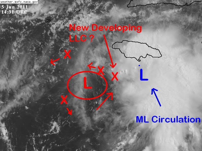
LOOP: http://wwwghcc.msfc.nasa.gov/cgi-bin/ge ... mframes=10
Speed that loop up. IMO you can clearly see a new center wanting to form near or under the convection. Not predicting development, just having fun observing.
Speed that loop up. IMO you can clearly see a new center wanting to form near or under the convection. Not predicting development, just having fun observing.
0 likes
M a r k
- - - - -
Join us in chat: Storm2K Chatroom Invite. Android and IOS apps also available.
The posts in this forum are NOT official forecasts and should not be used as such. Posts are NOT endorsed by any professional institution or STORM2K.org. For official information and forecasts, please refer to NHC and NWS products.


-
tolakram
- Admin
- Posts: 20185
- Age: 62
- Joined: Sun Aug 27, 2006 8:23 pm
- Location: Florence, KY (name is Mark)
Re: ATL: INVEST 94L - DISCUSSION
Graphic of what I'm seeing above.

0 likes
M a r k
- - - - -
Join us in chat: Storm2K Chatroom Invite. Android and IOS apps also available.
The posts in this forum are NOT official forecasts and should not be used as such. Posts are NOT endorsed by any professional institution or STORM2K.org. For official information and forecasts, please refer to NHC and NWS products.
- - - - -
Join us in chat: Storm2K Chatroom Invite. Android and IOS apps also available.
The posts in this forum are NOT official forecasts and should not be used as such. Posts are NOT endorsed by any professional institution or STORM2K.org. For official information and forecasts, please refer to NHC and NWS products.
-
vbhoutex

- Storm2k Executive
- Posts: 29148
- Age: 74
- Joined: Wed Oct 09, 2002 11:31 pm
- Location: Cypress, TX
- Contact:
Re: ATL: INVEST 94L - DISCUSSION
Personal Forecast Disclaimer:
The posts in this forum are NOT official forecast and should not be used as such. They are just the opinion of the poster and may or may not be backed by sound meteorological data. They are NOT endorsed by any professional institution or storm2k.org. For official information, please refer to the NHC and NWS products.
I just looked at a loop of the visible. I still do not see any kind of defined LLC. There is definitely a broad low SW of Jamaica pretty much as wxman57 pointed out. Just to the West of the heavier convection there may be a well defined mlc which could work it's way to the surface. With the obvious shear just to its NW I don't see intensification into a classifiable TC anytime within the next 24 hours if not longer. When/If it does make it to TC status upper level patterns, present and progged suggest a N to NE track which could be good for Florida if 1)it isn't too strong and 2)if it initializes far enough W to track across Florida. I don't see any threat to any other part of the GOM basin at this time.
0 likes
Skywarn, C.E.R.T.
Please click below to donate to STORM2K to help with the expenses of keeping the site going:

Please click below to donate to STORM2K to help with the expenses of keeping the site going:
Re: ATL: INVEST 94L - DISCUSSION
You can tell this has something to it by the shape of the convection and the fact it rebounded from yesterday's huge d-min. There's obviously shear on it from the displacement.
Looking out the window conditions are unfavorable with spring-like dry air and blustery winds. Though this is where June Florida cyclones develop and outlast the negative conditions they move into in the Gulf.
Looking out the window conditions are unfavorable with spring-like dry air and blustery winds. Though this is where June Florida cyclones develop and outlast the negative conditions they move into in the Gulf.
0 likes
-
Dean4Storms
- S2K Supporter
- Posts: 6358
- Age: 63
- Joined: Sun Aug 31, 2003 1:01 pm
- Location: Miramar Bch. FL
17.2N 78W looks suspicious too me this morning. Almost due south of the western tip of Jamaica under the convection there. May have a LLC getting established there. Convection such as this could easily set up the LLC there along this trough. I still see the broad circulation but it is losing to this area IMO.
0 likes
-
Dean4Storms
- S2K Supporter
- Posts: 6358
- Age: 63
- Joined: Sun Aug 31, 2003 1:01 pm
- Location: Miramar Bch. FL
Re: ATL: INVEST 94L - DISCUSSION
tolakram wrote:LOOP: http://wwwghcc.msfc.nasa.gov/cgi-bin/ge ... mframes=10
Speed that loop up. IMO you can clearly see a new center wanting to form near or under the convection. Not predicting development, just having fun observing.
I think we are seeing the same area just south of the western tip of Jamaica under the latest convection there. I can clearly see LL clouds tracking NE into the convection edge SW of it instead of racing away as you would expect with convection outflow and LL clouds moving southward just to the NW of the convective burst.
0 likes


-
Dean4Storms
- S2K Supporter
- Posts: 6358
- Age: 63
- Joined: Sun Aug 31, 2003 1:01 pm
- Location: Miramar Bch. FL
Re:
NDG wrote:The circulation south of Kingston is in the mid levels not at the surface.
My comment and position is south of the western tip (Negril), not eastern where Kingston is located.
Just clarifying if you were responding to my post.
0 likes
Who is online
Users browsing this forum: No registered users and 9 guests