Global model runs discussion

Moderator: S2k Moderators

Message
Author
User avatar
cycloneye
Admin
Admin
Posts: 145322
Age: 68
Joined: Thu Oct 10, 2002 10:54 am
Location: San Juan, Puerto Rico

Re: Global Model Runs Discussion

#2081 Postby cycloneye » Sat Jun 04, 2011 11:55 am

This is as our friend ROCK says, Lala-land. So take this as it is 16 days out. :) GFS shows unsettled weather in the Western Caribbean. Of course,we know the drill.

Image

Uploaded by imageshack.us
0 likes   
Visit the Caribbean-Central America Weather Thread where you can find at first post web cams,radars
and observations from Caribbean basin members Click Here

User avatar
cycloneye
Admin
Admin
Posts: 145322
Age: 68
Joined: Thu Oct 10, 2002 10:54 am
Location: San Juan, Puerto Rico

Re: Global Model Runs Discussion

#2082 Postby cycloneye » Tue Jun 07, 2011 12:48 pm

Again,is very long range,but GFS has a weak lopsided TS in the GOM. We know the drill about these long range runs, so is a wait and see game. Note that the above post has a graphic of the GFS run at 384 hours on the 20th,and this run at 312 hours is also for the 20th.

Image

Uploaded by imageshack.us
0 likes   
Visit the Caribbean-Central America Weather Thread where you can find at first post web cams,radars
and observations from Caribbean basin members Click Here

JonathanBelles
Professional-Met
Professional-Met
Posts: 11430
Age: 35
Joined: Sat Dec 24, 2005 9:00 pm
Location: School: Florida State University (Tallahassee, FL) Home: St. Petersburg, Florida
Contact:

#2083 Postby JonathanBelles » Tue Jun 07, 2011 6:36 pm

I'm beginning to watch the area around Puerto Rico. A couple models are showing a quick spin up to the NE of PR in the coming days. It should be hit with the same shear as 94L, but I thought I would mention it anyway.
0 likes   

User avatar
cycloneye
Admin
Admin
Posts: 145322
Age: 68
Joined: Thu Oct 10, 2002 10:54 am
Location: San Juan, Puerto Rico

Re: Global Model Runs Discussion

#2084 Postby cycloneye » Tue Jun 07, 2011 8:45 pm

Hmmm, what is this that ECMWF is showing comming from the east tracking into the Eastern Caribbean?

6/7/11 12z ECMWF Loop

Image

Uploaded by imageshack.us
0 likes   
Visit the Caribbean-Central America Weather Thread where you can find at first post web cams,radars
and observations from Caribbean basin members Click Here

User avatar
Ivanhater
Storm2k Moderator
Storm2k Moderator
Posts: 11161
Age: 38
Joined: Fri Jul 01, 2005 8:25 am
Location: Pensacola

Re: Global Model Runs Discussion

#2085 Postby Ivanhater » Wed Jun 08, 2011 12:06 am

00z GFS

Image
0 likes   
Michael

User avatar
srainhoutx
S2K Supporter
S2K Supporter
Posts: 6919
Age: 67
Joined: Sun Jan 14, 2007 11:34 am
Location: Haywood County, NC
Contact:

Re: Global Model Runs Discussion

#2086 Postby srainhoutx » Wed Jun 08, 2011 7:33 am

Some interesting developments in the long range via the Euro and the GFS as mischief continues to show up on the la la land charts. The Euro suggests a disturbance nearing the Islands in the day 7-10 time frame while the GFS track a weak vort across the Caribbean that begins to develop around the 19-21, +/- a day or two. There are also suggestions the an MJO pulse will arrive near that time, so there may be something to the models sniffing out some development.
0 likes   
Carla/Alicia/Jerry(In The Eye)/Michelle/Charley/Ivan/Dennis/Katrina/Rita/Wilma/Ike/Harvey

Member: National Weather Association
Wx Infinity Forums
http://wxinfinity.com/index.php

Facebook.com/WeatherInfinity
Twitter @WeatherInfinity

User avatar
wxman57
Moderator-Pro Met
Moderator-Pro Met
Posts: 22979
Age: 67
Joined: Sat Jun 21, 2003 8:06 pm
Location: Houston, TX (southwest)

Re: Global Model Runs Discussion

#2087 Postby wxman57 » Wed Jun 08, 2011 8:41 am

I'm not seeing anything to indicate any development for the next few weeks. In fact, June may turn out rather quiet with no storms. 40-day CHI indicating sinking air moving into the western Atlantic Basin now, and it may remain there through June. Ensemble GFS indicating no MJO activity for the next month.

http://www.cpc.ncep.noaa.gov/products/p ... egfs.shtml

Check out all the MJO models at the link below. No MJO activity reaching the eastern Pacific in June.
http://www.cpc.ncep.noaa.gov/products/p ... r_wh.shtml

Sinking air, no MJO for at least the next month, and a weak wave train in the Atlantic should add up to some quiet weeks ahead, perhaps through the 4th of July.

Image
0 likes   

User avatar
cycloneye
Admin
Admin
Posts: 145322
Age: 68
Joined: Thu Oct 10, 2002 10:54 am
Location: San Juan, Puerto Rico

Re: Global Model Runs Discussion

#2088 Postby cycloneye » Wed Jun 08, 2011 8:53 am

:uarrow: There is another graphic that has the MJO entering the Atlantic by the last week of June. Which one is right?

Image
0 likes   
Visit the Caribbean-Central America Weather Thread where you can find at first post web cams,radars
and observations from Caribbean basin members Click Here

User avatar
srainhoutx
S2K Supporter
S2K Supporter
Posts: 6919
Age: 67
Joined: Sun Jan 14, 2007 11:34 am
Location: Haywood County, NC
Contact:

Re: Global Model Runs Discussion

#2089 Postby srainhoutx » Wed Jun 08, 2011 8:56 am

The GFS is less than stellar predicting MJO occurrences, IMO. Trends have been to disregard that 40 day cycle as it has not verified well of late.
0 likes   
Carla/Alicia/Jerry(In The Eye)/Michelle/Charley/Ivan/Dennis/Katrina/Rita/Wilma/Ike/Harvey

Member: National Weather Association
Wx Infinity Forums
http://wxinfinity.com/index.php

Facebook.com/WeatherInfinity
Twitter @WeatherInfinity

User avatar
wxman57
Moderator-Pro Met
Moderator-Pro Met
Posts: 22979
Age: 67
Joined: Sat Jun 21, 2003 8:06 pm
Location: Houston, TX (southwest)

Re: Global Model Runs Discussion

#2090 Postby wxman57 » Wed Jun 08, 2011 9:07 am

cycloneye wrote::uarrow: There is another graphic that has the MJO entering the Atlantic by the last week of June. Which one is right?

http://www.icess.ucsb.edu/asr/MJO.forecast.olr.png


Luis, I believe that the MJO signal in the graphic you posted is in the Indian Ocean and West Pacific. What you're seeing as far as the OLR anomaly in the East Pac and Caribbean late this month is not an MJO signal. And I'd be very careful believing that graphic. I notice that they took down the verification link on their website. I've compared that particular forecast with the verification for the past few years and have found that much of the time the forecast is exactly opposite of what actually happens. I've been burned by that particular graphic on that web site in the past.

We actually had a conference call with Dr. Wheeler (of the Wheeler diagram) last year to go over it and the MJO signal.
0 likes   

User avatar
wxman57
Moderator-Pro Met
Moderator-Pro Met
Posts: 22979
Age: 67
Joined: Sat Jun 21, 2003 8:06 pm
Location: Houston, TX (southwest)

Re: Global Model Runs Discussion

#2091 Postby wxman57 » Wed Jun 08, 2011 9:13 am

srainhoutx wrote:The GFS is less than stellar predicting MJO occurrences, IMO. Trends have been to disregard that 40 day cycle as it has not verified well of late.

It's not just the GFS, it's every model on the MJO site. They all keep the MJO signal very weak and in the Indian Ocean to West Pac for quite a while.

http://www.cpc.ncep.noaa.gov/products/p ... r_wh.shtml
0 likes   

User avatar
srainhoutx
S2K Supporter
S2K Supporter
Posts: 6919
Age: 67
Joined: Sun Jan 14, 2007 11:34 am
Location: Haywood County, NC
Contact:

Re: Global Model Runs Discussion

#2092 Postby srainhoutx » Wed Jun 08, 2011 11:30 am

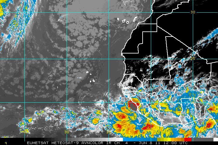
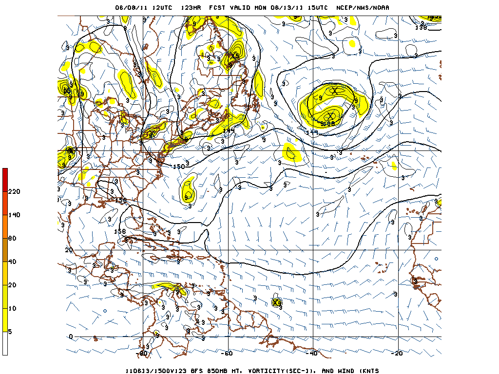
Here is the culprit... :wink:

Image

Image
0 likes   
Carla/Alicia/Jerry(In The Eye)/Michelle/Charley/Ivan/Dennis/Katrina/Rita/Wilma/Ike/Harvey

Member: National Weather Association
Wx Infinity Forums
http://wxinfinity.com/index.php

Facebook.com/WeatherInfinity
Twitter @WeatherInfinity

User avatar
TYNI
S2K Supporter
S2K Supporter
Posts: 550
Age: 58
Joined: Sun Sep 07, 2008 12:59 pm
Location: Ontario, Canada

Re: Global Model Runs Discussion

#2093 Postby TYNI » Wed Jun 08, 2011 4:38 pm

:uarrow: Looks like the train is being loaded, soon to depart...
0 likes   
Personal Forecast Disclaimer:
The posts in this forum are NOT official forecast and should not be used as such. They are just the opinion of the poster and may or may not be backed by sound meteorological data. They are NOT endorsed by any professional institution or storm2k.org. For official information, please refer to the NHC and NWS products.

User avatar
Cainer
Tropical Storm
Tropical Storm
Posts: 188
Age: 34
Joined: Mon May 05, 2008 3:26 pm
Location: Yarmouth, Nova Scotia

#2094 Postby Cainer » Wed Jun 08, 2011 5:34 pm

That's a pretty well-developed wave for so early in the season. Interesting that the GFS tries to do something with it. Most likely it'll poof when it fully emerges, but it would be fun to track something similar to 92L from June of last year.
0 likes   

User avatar
cycloneye
Admin
Admin
Posts: 145322
Age: 68
Joined: Thu Oct 10, 2002 10:54 am
Location: San Juan, Puerto Rico

Re: Global Model Runs Discussion

#2095 Postby cycloneye » Wed Jun 08, 2011 10:21 pm

Interesting discussion from the San Juan NWS about the Eastern Atlantic wave and model scenarios.

AREA FORECAST DISCUSSION...UPDATED
NATIONAL WEATHER SERVICE SAN JUAN PR
748 PM AST WED JUN 8 2011

LATEST GFS AND ECMWF MODELS HAVE A NICE DEPICTION OF AN AFRICAN
EASTERLY WAVE AND ASSOCIATED WIND SURGE PASSING ACROSS THE ERN
CARIB NEXT THU JUN 16. THIS SEEMS TO BE ASSOCIATED WITH A CLUSTER
OF STRONG CONVECTION CURRENTLY LOCATED NEAR 10N AND 20W. WEAKENING
MJO/NEGATIVE 200 MB VELOCITY POTENTIAL ANOMALIES ACROSS THE WRN
HEMISPHERE AND TIME OF THE YEAR DO NOT FAVOR ANY TC DEVELOPMENT.
ONE INTERESTING NOTE IS LACK OF SAHARAN DUST ACROSS THE TROP ATLC
AND WRN AFRICA ATTM WHICH TYPICALLY TENDS TO DOMINATE THIS AREA
DURING THE MONTH OF JUNE. NESDIS BLENDED TPW IMAGERY ALSO SHOWS
TROP ATLC WITH A HIGHER WATER VAPOR CONTENT THAN NORMAL PERHAPS A
HARBINGER OF THINGS TO COME LATER THIS HURRICANE SEASON.
0 likes   
Visit the Caribbean-Central America Weather Thread where you can find at first post web cams,radars
and observations from Caribbean basin members Click Here

User avatar
Macrocane
Category 5
Category 5
Posts: 4218
Age: 36
Joined: Sun May 24, 2009 5:35 pm
Location: El Salvador

Re: Global Model Runs Discussion

#2096 Postby Macrocane » Wed Jun 08, 2011 10:25 pm

Very interesting indeed. If 1996 and 2008 are analogs I wouldn't be surprised to see early Cape Verde activity like the Berthas of those seasons.
0 likes   

User avatar
LaBreeze
Category 5
Category 5
Posts: 1497
Joined: Thu Sep 04, 2003 1:57 pm
Location: SW Louisiana

Re: Global Model Runs Discussion

#2097 Postby LaBreeze » Fri Jun 10, 2011 12:55 am

TYNI wrote::uarrow: Looks like the train is being loaded, soon to depart...

"All aboard for points west" - not liking the thought
0 likes   

User avatar
Hybridstorm_November2001
S2K Supporter
S2K Supporter
Posts: 2811
Joined: Sat Aug 21, 2004 2:50 pm
Location: SW New Brunswick, Canada
Contact:

Re: Global Model Runs Discussion

#2098 Postby Hybridstorm_November2001 » Sat Jun 11, 2011 12:44 pm

Here is the current (updated daily) SAL graphic:

Image

Speaking of our old friend SAL, he is indeed looking rather sickly for this time of year.
0 likes   

User avatar
Ivanhater
Storm2k Moderator
Storm2k Moderator
Posts: 11161
Age: 38
Joined: Fri Jul 01, 2005 8:25 am
Location: Pensacola

Re: Global Model Runs Discussion

#2099 Postby Ivanhater » Sat Jun 11, 2011 6:28 pm

The GFS is still advertising a storm in the Gulf in the long range. It is interesting looking at the evolution of this. A westward moving tropical wave slows in the Western Caribbean as it approaches the Yucatan and rounds the edge of the upper high. The end of June might be interesting.

[img]Image

Uploaded with ImageShack.us[/img]
0 likes   
Michael

BigB0882
S2K Supporter
S2K Supporter
Posts: 2284
Joined: Thu Jul 03, 2003 12:08 am
Location: Baton Rouge, LA
Contact:

#2100 Postby BigB0882 » Sat Jun 11, 2011 11:05 pm

Is that a sheared system? I see the L and then the heavy precip is all to the north and east. I know details this far out are just fantasy but I am asking because if they see heavy shear in the region then we shouldn't have to worry about anything too major popping up.
0 likes   


Return to “2015”

Who is online

Users browsing this forum: No registered users and 12 guests